คู่มือพื้นที่ไม่ได้รับความคุ้มครองจากเขื่อนกั้นน้ำในเมืองลอนเซสตัน
Riverine flooding and flash flooding information for communities and properties in Launceston outside the levee protected areas
For levee protected areas, see the related flood guides for
Version 1.1 April 2026 – see the PDF version
This flood guide is for people in the areas of Launceston not protected by levees. Even if your home is not flooded, everyone around Launceston would be impacted by a major flood in the city. This guide also covers minor and moderate flooding, plus flash flooding in all areas of the city.
Parts of Launceston can flood from the
- kanamaluka / River Tamar Estuary
- North Esk River
- South Esk River.
There are also some minor waterways that can flood properties and roadways.
Launceston levee protected areas
Launceston’s levees reduce flood risk for many areas along the major rivers. However, there is no guarantee the levees will withstand a major flood. Experiences in other countries show that levees can fail, both gradually and suddenly. If the levees fail, low lying parts of the city may flood quickly. In major floods, people in the levee protected areas should evacuate in case
- the levees fail, or
- flood waters overtop the levees.
Please see the related flood guides for the levee protected areas of
These guides for the levee protected areas have important information about
- triggers for evacuation in major flood events
- how to evacuate, including evacuation routes to use.
If the North and/or South Esk Rivers may reach certain heights, these areas will have:
- A voluntary evacuation warning – where people are advised to leave for their safety
- A mandatory evacuation warning – where people should leave those areas for their safety, and so gas, electricity and water can be cut for those areas.
- In major flood events, people outside flood prone areas need to be aware that
- Major traffic routes through the city may be cut
- Traffic is likely to be very heavy
- There may be cuts to some essential services, such as water treatment.
- There may be cuts to some other services as major transport routes are cut.
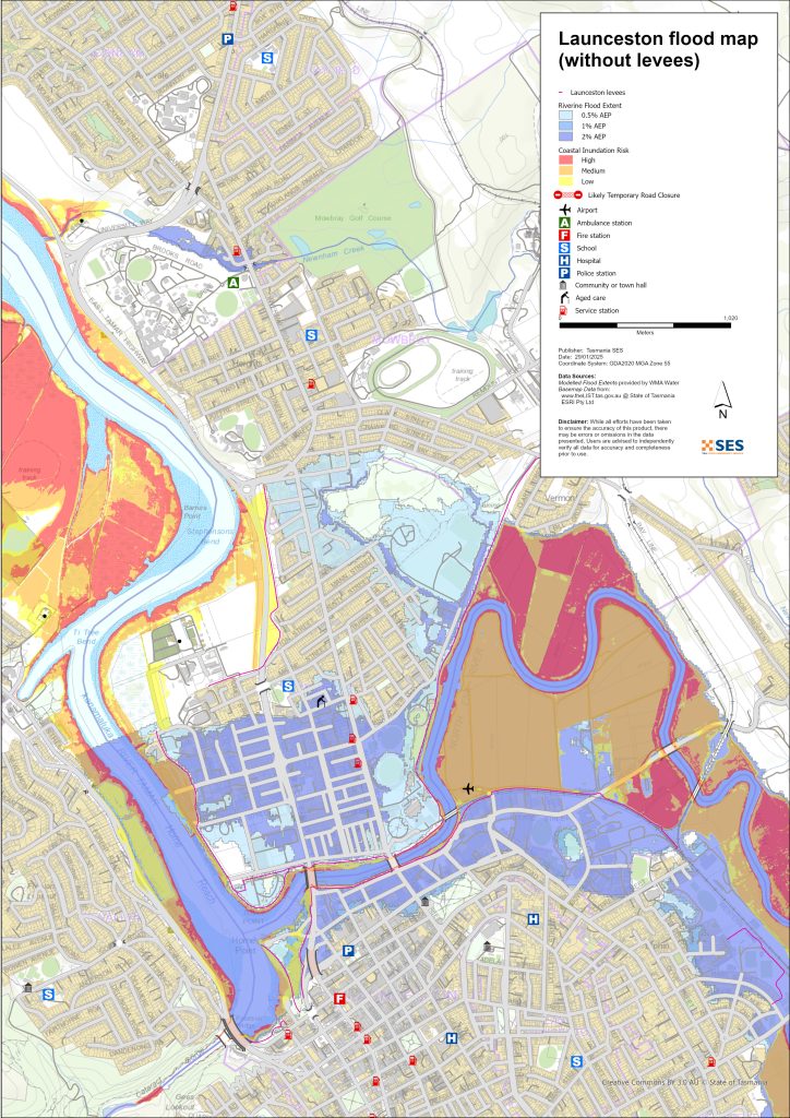
Areas that can flood outside the levee protected areas
Rivers can flood some areas outside the levee protected areas. High tides can also increase water levels in areas closer to the River Tamar.
For more detailed flood maps, see www.launceston.tas.gov.au/Emergency-Management-Hub/1.-Understand-your-risk/Flood to
- Check the Launceston Flood Maps to assess your level of riverine flood risk.
- Check the Urban (Stormwater) Flooding Map for flash flooding storm water flood maps.
- Find out more about Launceston’s flood levees.
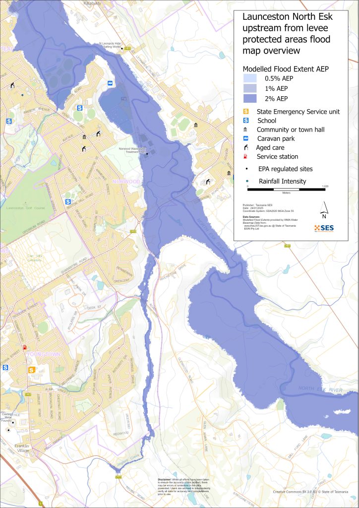
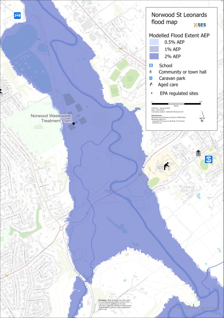
North Esk River surrounding low-lying areas
- Corra Linn, Patersons Island scout camp and nearby historic fishponds plus some homes
- St Leonards around
- Station Road
- Hoblers Bridge Road
- Waverley Road
- Ravenswood Road
- Norwood and Newstead areas outside the levee protected area, including the caravan park on Sandown Road (Old Mac’s Farm)
- Waverley – Boomer Road
South Esk and River Tamar low-lying surrounding areas
- Cataract Gorge Reserve – First Basin
- Seaport Precinct
- Kings Wharf area
- West Tamar Highway area
Other low-lying areas exposed to flash flooding/ overland flow
Flash flooding is flooding that happens very soon after heavy rain falls. There can often be little warning aside from a general severe weather warning. There are many minor waterways around Launceston that can flood quickly. Low-lying areas that can flood due to flash flooding or overland flow include parts of
- Relbia near Jinglers Creek
- Kingsmeadows/ Punchbowl
- Newnham – from flash flooding from Newnham Creek and Barnards Creek
- South Launceston
- Waverley
- Faraday Street from Distillery Creek
- Ravenswood Road from Distillery Creek/ North Esk River.
If there is very intense rain, there can be storm water run-off that can affect buildings and roads in any area.
Areas surrounding Launceston
For information about flooding in surrounding areas, see nearby related guides for:
- Lilydale and surrounds
- Nunamara and surrounds – currently under development
- Hadspen/ Blackstone Heights
คุณมีความเสี่ยงต่อน้ำท่วมหรือไม่
The Launceston area has a long history of flooding. Since European settlement
- 1852, 1863 and 1893 had serious flood events recorded for Launceston.
- 1929 was the most severe flooding recorded in modern history. Over a thousand homes and buildings were damaged, with some swept from their foundations. The two suspension bridges over the Gorge area were damaged. Four thousand people were evacuated from Invermay, Inveresk and Margaret Street areas. It was not until 1940 that Launceston recovered from the flood. The 1929 floods provided incentive to build the levees.
- 2016 – ลาングส์ตันเตรียมพร้อมสำหรับเหตุการณ์น้ำท่วมใหญ่และปิดกั้นบางส่วนของเขื่อนกั้นน้ำ. การปรับปรุงระบบเขื่อนกั้นน้ำก่อนหน้านี้ช่วยหลีกเลี่ยงการสูญเสียประมาณ $216 ล้านบาท หากเขื่อนกั้นน้ำเก่าล้มเหลว.
- 2022 – ลอนเซสตันเกือบจะประสบกับเหตุการณ์น้ำท่วมใหญ่.
การพยากรณ์ คำเตือน และการสังเกตการณ์ของสำนักงานอุตุนิยมวิทยา (BoM)
BoM ออก เฝ้าระวังน้ำท่วม when predicted weather might cause floods in the area. A Flood Watch may:
- สำหรับพื้นที่เฉพาะ เช่น แม่น้ำเซาท์เอสก์ catchment, for example, or
- ให้เป็นแบบทั่วไป เช่น สำหรับ ลุ่มแม่น้ำตอนกลางตอนเหนือ
ปัญหา BoM ประกาศเตือนภัยน้ำท่วม with specific flood heights for the South Esk and North Esk Rivers. Flood gauges along the rivers give warnings of
- flood heights, and
- the possible impacts in Launceston.
High tides can also add to flooding.
The Bureau will issue Minor, Moderate or Major flood warnings when the North Esk or South Esk Rivers are likely to reach certain heights. The table below also shows the trigger levels for SES to issue evacuation warnings due to flooding from these rivers.
| River gauge sites | เล็กน้อย | ปานกลาง | Major flood | Evacuation Critical Decision Points |
| North Esk River @ Corra Linn |
2.7 mAHD 80 m³/s |
3.6 mAHD 200 m³/s |
4.9 mAHD 419 m³/s Approx. 20% AEP |
6.1 mAHD 800 m³/s About 2% AEP Newstead Levee Protected Area (LPA) |
| South Esk River @ Trevallyn Pond |
128.2 mAHD approx. 420 m³/s > 20% AEP |
129.9 mAHD approx. 1500 m³/s Approx. 10%AEP |
130.9 mAHD approx. 2,000 m³/s Approx. 5% AEP |
2250 m³/s Between 2%-1% AEP Invermay /Inveresk Levee Protected Area |
|
2500 m³/s – Between <1% AEP City /East Launceston Levee Protected Area |
||||
|
3500 m³/s – Between >1% AEP Margaret Street Levee Protected Area |
Notes:
- m³/s (cumec) – one cubic meter of water flowing past a point in one second. One cubic meter of water equals one thousand litres and weighs one tonne.
- Annual Exceedance Probability (%AEP) is the likelihood of such an event happening any given year, based on historical records up to 2016. With climate change, this likelihood is changing. Updates of this data is underway.
- mAHD – Metres above height datum. This is a local height for the gauging site.
ฉันควรทำอย่างไร
-
- ตรวจสอบแผนที่เพื่อดูว่าบ้านหรือธุรกิจของคุณอาจเกิดน้ำท่วมหรือไม่.
-
- ประเมินบ้านหรือธุรกิจของคุณและเตรียมพร้อมเพื่อลดความเสียหายจากน้ำท่วมที่อาจเกิดขึ้น.
-
- ตรวจสอบว่าคุณสามารถเดินทางกลับบ้าน ที่ทำงาน หรือโรงเรียนได้อย่างปลอดภัยในช่วงน้ำท่วมหรือไม่.
-
- จัดทำแผนฉุกเฉินประจำบ้าน พิจารณาว่าคุณจำเป็นต้องอพยพก่อนเกิดน้ำท่วมหรือไม่ ดู เตรียมพร้อมรับมือเหตุฉุกเฉิน– คู่มือสำหรับบุคคลและครัวเรือนในการเตรียมพร้อมรับมือกับเหตุฉุกเฉิน.
-
- If you are a primary producer, the Farm Flood Readiness Kit provides advice on preparing for a flood to help protect your business and stock.
-
- If you run a business or other organisation, check out the Tasmanian Government’s Emergency Ready Business tool online
-
- หากคุณอาจถูกกักตัวและคุณต้องเข้าถึงบริการ คุณอาจต้องอพยพออกไปก่อน.
-
- หากคุณกำลังตั้งแคมป์ในพื้นที่เสี่ยงต่อน้ำท่วม ควรติดตามข่าวสารอย่างใกล้ชิด และย้ายไปยังที่สูงทันทีหากคาดว่าจะมีน้ำท่วม.
น้ำท่วม เช่น ที่แสดงในแผนที่ หรืออาจจะหนักกว่านี้ จะเกิดขึ้นอีกครั้ง ไม่มีน้ำท่วมสองครั้งที่เหมือนกัน.
หากคุณอาศัยอยู่ในพื้นที่ลุ่มต่ำหรือใกล้ทางน้ำ บ้านของคุณอาจถูกน้ำท่วม แม้ว่าบ้านของคุณจะปลอดภัย คุณอาจต้องอ้อมไปรอบๆ บริเวณที่น้ำท่วม หรือทางเข้าบ้านของคุณอาจถูกตัดขาด ห้ามขับรถหรือเดินลุยเข้าไปในน้ำท่วมเด็ดขาด ถนนและสะพานอาจถูกพัดหายไปหรือไม่ปลอดภัย หลีกเลี่ยงการเดินทางในช่วงน้ำท่วม.
การรู้ว่าต้องทำอะไรสามารถช่วยชีวิตคุณและปกป้องทรัพย์สินของคุณได้ การมีแผนรับมือเหตุฉุกเฉินที่บ้านเป็นวิธีเตรียมพร้อมที่ดีที่สุดวิธีหนึ่ง กำหนดเหตุการณ์สภาพอากาศและปริมาณน้ำฝนที่จะกระตุ้นให้ลงมือปฏิบัติ.
การพยากรณ์ คำเตือน และการสังเกตการณ์ของสำนักงานอุตุนิยมวิทยา (BoM)
BoM ออก เฝ้าระวังน้ำท่วม when predicted weather might cause floods in the area. A Flood Watch may:
- สำหรับพื้นที่เฉพาะ เช่น แม่น้ำเซาท์เอสก์ catchment, for example, or
- ให้เป็นแบบทั่วไป เช่น สำหรับ ลุ่มแม่น้ำตอนกลางตอนเหนือ
ปัญหา BoM ประกาศเตือนภัยน้ำท่วม with specific flood heights for the South Esk and North Esk Rivers. Flood gauges along the rivers give warnings of
- flood heights, and
- the possible impacts in Launceston.
High tides can also add to flooding.
The Bureau will issue Minor, Moderate or Major flood warnings when the North Esk or South Esk Rivers are likely to reach certain heights. The table below also shows the trigger levels for SES to issue evacuation warnings due to flooding from these rivers.
| River gauge sites | เล็กน้อย | ปานกลาง | Major flood | Evacuation Critical Decision Points |
| North Esk River @ Corra Linn | 2.7 mAHD
80 m³/s |
3.6 mAHD
200 m³/s |
4.9 mAHD
419 m³/s Approx. 20% AEP |
6.1 mAHD
800 m³/s About 2% AEP Newstead Levee Protected Area (LPA) |
| South Esk River @ Trevallyn Pond | 128.2 mAHD approx. 420 m³/s
> 20% AEP |
129.9 mAHD approx.
1500 m³/s Approx. 10%AEP |
130.9 mAHD approx.
2,000 m³/s Approx. 5% AEP |
2250 m³/s
Between 2%-1% AEP Invermay /Inveresk Levee Protected Area |
| 2500 m³/s – Between <1% AEP
City /East Launceston Levee Protected Area |
||||
| 3500 m³/s – Between >1% AEP
Margaret Street Levee Protected Area |
Notes:
- m³/s (cumec) – one cubic meter of water flowing past a point in one second. One cubic meter of water equals one thousand litres and weighs one tonne.
- Annual Exceedance Probability (%AEP) is the likelihood of such an event happening any given year, based on historical records up to 2016. With climate change, this likelihood is changing. Updates of this data is underway.
- mAHD – Metres above height datum. This is a local height for the gauging site.
ทำความเข้าใจคำเตือนและข้อมูลสำคัญ
เฝ้าระวังสิ่งที่เกิดขึ้นรอบตัวคุณ ตรวจสอบพยากรณ์อากาศ การสังเกตการณ์ และคำเตือนเป็นประจำ.
 |
คำแนะนำ (สีเหลือง): มีเหตุการณ์เกิดขึ้น ยังไม่มีอันตรายใดๆ โปรดติดตามความคืบหน้า เผื่อสถานการณ์เปลี่ยนแปลง. |
 |
ดูและดำเนินการ (สีส้ม): ระดับภัยคุกคามสูงขึ้น สภาพการณ์กำลังเปลี่ยนแปลงและคุณต้องเริ่มดำเนินการทันทีเพื่อปกป้องตัวเองและครอบครัว |
 |
คำเตือนฉุกเฉิน (สีแดง): คำเตือนฉุกเฉินคือระดับการเตือนภัยสูงสุด คุณอาจตกอยู่ในอันตรายและต้องดำเนินการทันที ความล่าช้าใดๆ ในตอนนี้จะทำให้ชีวิตของคุณตกอยู่ในความเสี่ยง. |
 |
อัปเดตชุมชน (สีน้ำเงิน): ข้อมูลและการอัปเดตเฉพาะสำหรับชุมชนที่ได้รับผลกระทบเกี่ยวกับเหตุการณ์หรืออุบัติการณ์เฉพาะ. |
| เหตุการณ์ (สีขาว): เหตุการณ์คือการเกิดขึ้นครั้งแรกของเหตุการณ์ก่อนที่จะกลายเป็นสัญญาณเตือนภัยฉุกเฉิน ทันทีที่ได้รับรายงานเหตุการณ์ TasALERT จะเผยแพร่ข้อมูลพื้นฐานรวมถึงประเภทและสถานที่เกิดเหตุ. |
ระดับน้ำท่วม
แม้ว่าน้ำท่วมแต่ละครั้งจะไม่เหมือนกัน แต่ต่อไปนี้คือสิ่งที่คุณคาดหวังได้จากระดับน้ำท่วมที่แตกต่างกันในพื้นที่ แม้ว่าทรัพย์สินของคุณจะไม่ถูกน้ำท่วม แต่คุณก็ต้องคำนึงถึงการเข้าถึงด้วย ระดับน้ำฝนที่แตกต่างกันสามารถทำให้น้ำท่วมได้ ขึ้นอยู่กับความรุนแรง ระยะเวลา และพื้นดินมีความชื้นมากน้อยเพียงใดก่อนหน้านี้ และปริมาณน้ำฝนที่ตก.
Minor Riverine flooding from North Esk/ South Esk and Tamar Rivers
North Esk at Corra Linn at least 2.7m
- Agricultural land/ riverside parklands, for example, St Leonards picnic ground
- Possible road closure – Henry Street
- Low-lying properties near the river on:
- Station Road
- Henry Street
- Killafaddy Street
- Old Mac’s Farm Caravan Park on Sandown Road
- Western railway line and yards
- Scotch Oakburn Park and Queechy Park
- South Esk at Trevallyn Pond at least 128.2m
- Agricultural land/ riverside parklands e.g. Cataract Gorge Reserve and Gorge Swimming Pool, Home Point Parade surrounds
- Kings Wharf
- Seaport Home Point Parade low lying areas
- West Tamar rowing club
- Henry Street area
- Flood waters may begin to impact the south-bound lane of the West Tamar Highway, with traffic diverted to alternate routes.
Moderate flooding from North Esk/ South Esk and Tamar Rivers
- Many levee flood gates will close, restricting movement through the city. Major routes to close across the river include:
- West Tamar Road
- Henry Street
North Esk at Corra Linn at least 3.6m
As per minor flooding, plus
- Station Road roadway and further low-lying properties near the river
- Henry Street further areas and low-lying properties
- Scotch Oakburn College oval/ workshop
- Hoblers Bridge Road and Netball Centre
- Low-lying properties on Killafaddy Road
- Low-lying properties on Glenwood Road
- Bill Grove roadway, Mowbray.
- South Esk at Trevallyn Pond at least 129.9m
- As per minor flooding plus
- West Tamar Highway both lanes diverted through side streets
- Seaport Boulevard
- There will be some impacts around Henry Street and other areas on the lower North Esk River
- 1600 m3/s @ Trevallyn Pond – voluntary evacuation parts of Invermay (see Invermay flood guide)
- Bill Grove roadway, Mowbray.
Major riverine flooding from North Esk/ South Esk and Tamar Rivers
North Esk at Corra Linn at least 4.9m (Approx 20% AEP)
As per moderate flooding, plus:
- Hart St flood levee closed, parts of Invermay levee closed
- Railyard flood gates are closed
- Blessington Road South Esk River crossing
- Further properties on Station Road
- Larmenier School grounds near the river
- Various sewage pump stations may be impacted
- Johnson Road/ Station Road
- 800 m3/s @ Corra Linn- Newstead – Hart St area mandatory evacuation (Approx 2%AEP)
- South Esk at Trevallyn Pond at least 130m (2000 m³/s)
- As per moderate flooding plus
- 2250 m³/s – Invermay Mandatory evacuation – see Invermay flood guide
- 2500 m³/s – Invermay levees may overtop. Mandatory evacuation of parts of Launceston city centre – see the flood guides for Launceston and East Launceston/ Launceston – Margaret Street area,
- Parts of Seaport area, Kings Wharf flooded
- Other areas – flash flooding from minor waterways (1-2%AEP)
- Flash flooding from minor waterways can happen quickly, with little specific warning. Areas at risk include
- Relbia Road bridge and some low-lying properties along
- Relbia Road
- Redwood Crescent
- Oppossum Road
- Glenwood Road.
- Kings Meadows near Kings Meadows Rivulet, including Hobart Road
- South Launceston low lying areas near Margaret Street/ Bathurst Street, including Midland Highway near the Wellington Street junction, and nearby low-lying properties
- Newstead low-lying roadways and properties, particularly near Robin Street
- East Launceston roadways and properties around Dowling St.
- Newnham, Lilydale Road and Bell Bay railway line at Barnards Creek crossing, plus several properties.
The maps in this guide show the level of flooding that has a 1% chance of happening any year, both with levee protecting some areas, and if the levees fail or are overtopped. They do not show overland flow/ rainwater run-off. Unless there is a severe storm bringing very heavy rain, the main flooding risks for Launceston are from the city’s major rivers.
Launceston’s two major river systems may flood at the same time and may have different levels of flooding during the same event. The kanamaluka/River Tamar is tidal and may also affect the flooding height.
You are likely to experience flooding such as that shown in the maps in your lifetime. Tasmanians need to prepare for flood events that may not happen often as well as the minor flooding they may have experienced.
In a major flood event, closed levee gates and flooded roads can cut the city of Launceston in three until waters recede:
- The Central Business District and areas to the south of the city centre
- Areas to the North and North East of the North Esk River/ Tamar
- Trevallyn/ Riverside area to the West and North West of the Tamar River
Depending on rainfall in surrounding areas, there may be alternative routes. However, traffic is likely to be very heavy.
Even if your home is not inundated, you should be prepared for
- major traffic routes through the city to be cut, and
- potential power and telecommunications outages.
If some areas there is a mandatory evacuation order for levee protected areas, electricity, water and gas will be switched off to
- reduce hazards, and
- protect assets so they can be restored as soon as possible after the event.
Travel in the area is likely to be difficult or impossible until
- roads are clear, and
- flood gates are reopened.
If you are safe at home or elsewhere, it is usually best you stay where you are until the flooding subsides, unless there is an emergency. If you need to evacuate, you should leave early, before flood waters rise.
Go to TasALERT.com or listen to ABC local radio for detailed up to date information and advice during heavy rainfall events.
รู้ความเสี่ยงของคุณ เตรียมพร้อม ลดความเสี่ยงเท่าที่ทำได้ เชื่อมต่อกับผู้อื่น ตื่นตัวเสมอ และดำเนินการอย่างปลอดภัย.
ก่อนน้ำท่วม
เตรียมพร้อมรับมือเหตุฉุกเฉิน – คู่มือสำหรับบุคคลและครัวเรือนในการเตรียมพร้อมรับมือกับเหตุฉุกเฉิน.
1. รู้จักความเสี่ยงของคุณ
น้ำท่วมมักเกิดขึ้นในแทสเมเนียและอาจก่อให้เกิดความเสียหายในวงกว้างและรุนแรง ในช่วง 200 ปีที่ผ่านมา มีผู้เสียชีวิตจากเหตุน้ำท่วมในแทสเมเนีย 78 ราย คู่มือนี้จัดทำขึ้นเพื่อช่วยให้คุณเข้าใจเกี่ยวกับความเสี่ยงจากน้ำท่วมในพื้นที่ของคุณ.
2. เตรียมบ้านของคุณ
เตรียมแผนฉุกเฉินที่ครอบคลุมพายุและน้ำท่วม
การคิดถึงสิ่งที่คุณจะทำในระหว่างพายุหรือน้ำท่วม หมายถึงคุณมีความพร้อมมากขึ้น และทุกคนจะปลอดภัยยิ่งขึ้น จัดทำแผนฉุกเฉินที่ทุกคนในครัวเรือนของคุณเข้าใจ มีรายการตรวจสอบเพื่อช่วยให้คุณคิดถึงแผนของคุณ – ดู เตรียมพร้อมรับมือเหตุฉุกเฉิน – คู่มือสำหรับบุคคลและครัวเรือนในการเตรียมพร้อมรับมือกับเหตุฉุกเฉิน.
ตรวจสอบแผนของคุณอย่างสม่ำเสมอ และทดสอบโดยสมาชิกทุกคนในครอบครัวลองนึกถึงสถานการณ์น้ำท่วมที่อาจส่งผลกระทบต่อครอบครัวของคุณ.
เตรียมชุดอุปกรณ์ฉุกเฉิน
พร้อมไป
-
- วิทยุไฟฉายใช้แบตเตอรี่ พร้อมแบตเตอรี่สำรอง
-
- ข้อมูลสำคัญ เช่น แผนฉุกเฉินของคุณ
-
- รายการเบอร์โทรศัพท์ฉุกเฉิน
-
- อาหารและน้ำ
-
- ชุดปฐมพยาบาล
-
- ถุงมือยาง หรือหนังที่แข็งแรง
จัดกระเป๋าเมื่อจำเป็น
-
- เสื้อผ้าที่อบอุ่น รองเท้าที่ทนทาน หรือรองเท้าบูท
-
- ยา แว่นตา หรือสิ่งของจำเป็นอื่นๆ
-
- โทรศัพท์มือถือและที่ชาร์จโทรศัพท์
-
- อาหารสัตว์เลี้ยงและสิ่งอื่น ๆ ที่พวกเขาต้องการ
-
- รูปถ่ายและของที่ระลึกพิเศษ
-
- เงิน
-
- เอกสารสำคัญ ตัวอย่างเช่น
-
- เอกสารประกัน
-
- หนังสือเดินทางและ
-
- สูติบัตร
-
- เอกสารสำคัญ ตัวอย่างเช่น
ทดสอบแบตเตอรี่วิทยุและไฟฉายเป็นประจำ.
3. ลดความเสี่ยงจากน้ำท่วมในบริเวณที่คุณสามารถทำได้
-
- คำนึงถึงพายุ น้ำท่วม และอันตรายอื่นๆ เมื่อซื้อ บำรุงรักษา หรือพัฒนาอสังหาริมทรัพย์.
-
- ตัดแต่งหรือโค่นต้นไม้และกิ่งก้านที่ยื่นเข้ามาเหนือบ้าน ธุรกิจ หรือใกล้สายไฟฟ้าบนทรัพย์สินของคุณ.
-
- รักษารางน้ำและท่อระบายน้ำของคุณให้โล่ง.
4. ติดต่อกับผู้อื่น
Know your neighbours and get involved in your community. A connected community is a safer and more resilient community in an emergency and can help everyone recover better afterwards. Check that family and neighbours are safe and aware of what’s happening.
ระหว่าง
5. Keep up to date
เฝ้าระวังสิ่งที่เกิดขึ้นรอบตัวคุณ ตรวจสอบพยากรณ์อากาศ การสังเกตการณ์ และคำเตือนเป็นประจำ.
-
- เดอะ กรมอุตุนิยมวิทยา เว็บไซต์.
6. Act Safe
-
- ดูแลเด็ก.
-
- เตรียมพร้อมรับมือการหยุดชะงักที่เป็นไปได้ของไฟฟ้า น้ำ หรืออินเทอร์เน็ต.
-
- ตรวจสอบชุดฉุกเฉินของคุณให้พร้อมใช้งาน.
-
- หลีกเลี่ยงพื้นที่ที่ถูกน้ำท่วม เช่น ท่อระบายน้ำ. ไม่ เดิน เล่น ขี่ หรือขับรถในน้ำท่วม คุณไม่สามารถมองเห็นสิ่งที่อยู่ใต้น้ำเสมอไป หรือน้ำมีความลึกหรือไหลเร็วเท่าใด ก็ตามเป็นเรื่องง่ายที่จะถูกพัดพาไปและจมน้ำในน้ำที่ไหลเร็วเพียง 20 ซม. น้ำท่วมอาจเป็นอันตรายได้.
เมื่อบ้านของคุณอาจถูกน้ำท่วม
-
- เก็บของใช้ในครัวเรือนไว้ในที่สูงเพื่อลดความเสียหายที่อาจเกิดขึ้น.
-
- ปิดไฟฟ้าและแก๊สหากสามารถทำได้อย่างปลอดภัย.
-
- วิธีที่ดีในการหยุดน้ำเสียไหลย้อนกลับเข้าบ้านของคุณคือการนำกระสอบทรายใส่ในถุงพลาสติก แล้วใช้กระสอบทรายเหล่านั้นอุดโถส้วมและปิดท่อระบายน้ำและอ่างล้างจาน.
-
- รีบออกไปก่อนที่คุณจะสามารถออกไปได้อย่างปลอดภัย.
หากคุณจำเป็นต้องอพยพ
-
- ปฏิบัติตามคำแนะนำจาก SES / ตำรวจแทสเมเนีย.
-
- นำชุดฉุกเฉินของคุณไปด้วย.
-
- ไปหาเพื่อนหรือญาติในที่ปลอดภัยกว่า หรือศูนย์พักพิง.
-
- บอกให้คนอื่นรู้ว่าคุณไปที่ไหน.
ดูแลสัตว์เลี้ยงของคุณ
You are responsible for your animals in an emergency. If you have pets and other animals it will take you longer to evacuate in a flood or other emergency. Move livestock from flood prone areas well before flood waters may rise. For more information see
หลีกเลี่ยงการเดินทางในช่วงที่มีพายุและหลังพายุ
-
- อย่าไปชมทิวทัศน์ จุดสนใจของนักท่องเที่ยวทำให้บริการฉุกเฉินล่าช้าและก่อให้เกิดอุบัติเหตุ.
-
- ระวังอันตรายต่างๆ เช่น
-
- น้ำท่วมถนน
-
- สายไฟฟ้าที่เสียหาย
-
- ดินถล่ม
-
- ถนนชำรุด
-
- ต้นไม้ล้มหรือหลังคาเหล็ก.
-
- ระวังอันตรายต่างๆ เช่น
-
- ห้ามขับรถฝ่ากระแสน้ำท่วมโดยเด็ดขาด เหตุการณ์เสียชีวิตและต้องได้รับการช่วยเหลือจากน้ำท่วมส่วนใหญ่เกิดจากผู้ขับขี่พยายามขับรถฝ่ากระแสน้ำท่วม.
-
- ขับรถช้าๆ และเปิดไฟหน้ารถบนถนนที่ไม่อยู่ในบริเวณน้ำท่วม.
หลังจาก
-
- โปรดคอยรับฟังข่าวสารล่าสุดของ ABC Local Radio การเปิดถนนอีกครั้ง การประชุมชุมชน และอื่นๆ.
-
- หากท่านออกจากบ้านแล้ว ห้ามกลับเข้าบ้านจนกว่า SES หรือตำรวจแทสเมเนียจะแจ้งว่าปลอดภัย.
-
- ระมัดระวังอันตรายบนท้องถนน เช่น โคลนหรือเศษขยะบนถนน ถนน/สะพานที่ชำรุด และเจ้าหน้าที่ที่กำลังทำงานทำความสะอาดและซ่อมแซม.
หากบ้านของคุณได้รับความเสียหาย
-
- อยู่ในระดับพื้นดินขณะตรวจสอบความเสียหาย ระวังต้นไม้ที่โค่นล้ม กระจกแตก หลังคาหลุดลุ่ย หรืออันตรายอื่นๆ.
-
- สวมรองเท้าบูท ถุงมือ และเสื้อผ้าป้องกันที่แข็งแรง.
-
- ใช้ไฟฉาย ห้ามใช้ไม้ขีดไฟหรือเทียนไขภายในอาคารที่ถูกน้ำท่วม.
-
- ต้มน้ำดื่มทุกครั้งจนกว่าจะได้รับแจ้งว่าน้ำประปาปลอดภัยอีกครั้ง.
-
- Do not turn on it is tested by a licensed electrician or gas fitter for safety.
-
- หากบ้านของคุณได้รับความเสียหาย และคุณต้องไปพักที่อื่น ให้นำชุดอุปกรณ์ฉุกเฉินและสัตว์เลี้ยงของคุณไปด้วย
-
- ถ่ายรูปความเสียหายที่พบ หากทำได้อย่างปลอดภัย แล้วติดต่อบริษัทประกันภัยของคุณ.
-
- ดูแลเด็ก.
-
- ตรวจสอบเพื่อนบ้านว่าโอเคหรือเปล่า.
สำหรับข้อมูลเพิ่มเติม ไปที่ www.ses.tas.gov.au
การรับทราบข้อมูลและข้อมูลเพิ่มเติม
Current warnings – TasALERT.com
Emergency Broadcasters – สถานีวิทยุ ABC ในพื้นที่ของคุณ
TASSES Social Media – facebook.com/sestasmania
การเตรียมพร้อมรับมือสถานการณ์น้ำท่วมฉุกเฉิน ses.tas.gov.au/flood-plan/
บริการถ่ายทอดแห่งชาติ (NRS) relayservice.gov.au
Local Emergency Broadcasters ABC 91.7FM
City of Launceston Launceston.tas.gov.au 6323 3000
ศูนย์จัดการเหตุฉุกเฉิน เมืองลอนเซสตัน
ข้อจำกัดความรับผิด
The maps show potential flooding risks from consistent levels of rainfall across catchments, such as a 1% Annual Exceedance Probability (AEP). In flooding events, rainfall is likely to be more inconsistent across a catchment, so these flood maps should be considered indicative only. The mapped areas of flood risk show higher probability of inundation. Other areas have lower probability of flooding, but in severe and rare events (rarer than 1%AEP), other lower areas may be also at risk of inundation.
ข้อมูลในคู่มือนี้เป็นข้อมูล ณ วันที่เผยแพร่ แม้ว่าจะได้ใช้ความพยายามอย่างเต็มที่เพื่อให้แน่ใจว่าข้อมูลที่นำเสนอมีความถูกต้องและเชื่อถือได้ แต่หน่วยบริการภาวะฉุกเฉินของรัฐจะไม่รับผิดชอบต่อข้อผิดพลาดหรือการละเว้นของข้อมูล โปรดดูมาตรฐาน ข้อความสงวนลิขสิทธิ์และข้อจำกัดความรับผิดชอบของรัฐบาลแทสเมเนีย สำหรับรายละเอียดเพิ่มเติม.
