ローンセストン 非堤防保護区域 洪水ガイド
Riverine flooding and flash flooding information for communities and properties in Launceston outside the levee protected areas
For levee protected areas, see the related flood guides for
Version 1.1 April 2026 – see the PDF version
This flood guide is for people in the areas of Launceston not protected by levees. Even if your home is not flooded, everyone around Launceston would be impacted by a major flood in the city. This guide also covers minor and moderate flooding, plus flash flooding in all areas of the city.
Parts of Launceston can flood from the
- kanamaluka / River Tamar Estuary
- North Esk River
- South Esk River.
There are also some minor waterways that can flood properties and roadways.
Launceston levee protected areas
Launceston’s levees reduce flood risk for many areas along the major rivers. However, there is no guarantee the levees will withstand a major flood. Experiences in other countries show that levees can fail, both gradually and suddenly. If the levees fail, low lying parts of the city may flood quickly. In major floods, people in the levee protected areas should evacuate in case
- the levees fail, or
- flood waters overtop the levees.
Please see the related flood guides for the levee protected areas of
These guides for the levee protected areas have important information about
- triggers for evacuation in major flood events
- how to evacuate, including evacuation routes to use.
If the North and/or South Esk Rivers may reach certain heights, these areas will have:
- A voluntary evacuation warning – where people are advised to leave for their safety
- A mandatory evacuation warning – where people should leave those areas for their safety, and so gas, electricity and water can be cut for those areas.
- In major flood events, people outside flood prone areas need to be aware that
- Major traffic routes through the city may be cut
- Traffic is likely to be very heavy
- There may be cuts to some essential services, such as water treatment.
- There may be cuts to some other services as major transport routes are cut.
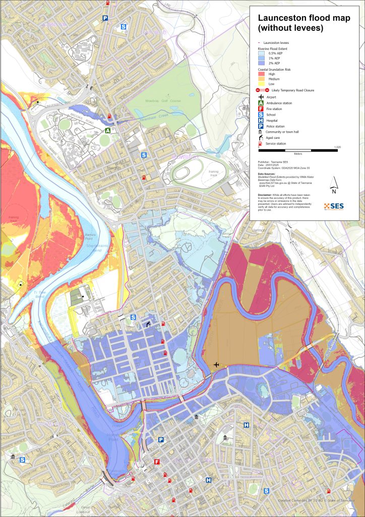
Areas that can flood outside the levee protected areas
Rivers can flood some areas outside the levee protected areas. High tides can also increase water levels in areas closer to the River Tamar.
For more detailed flood maps, see www.launceston.tas.gov.au/Emergency-Management-Hub/1.-Understand-your-risk/Flood to
- Check the Launceston Flood Maps to assess your level of riverine flood risk.
- Check the Urban (Stormwater) Flooding Map for flash flooding storm water flood maps.
- Find out more about Launceston’s flood levees.
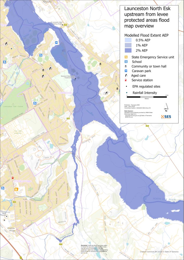
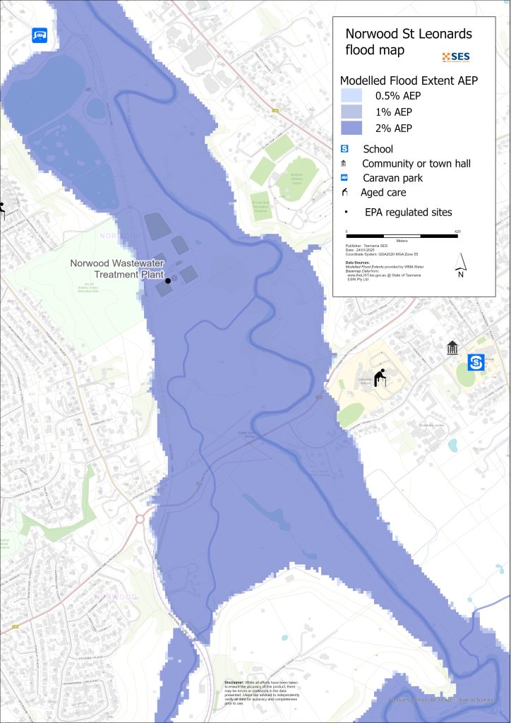
North Esk River surrounding low-lying areas
- Corra Linn, Patersons Island scout camp and nearby historic fishponds plus some homes
- St Leonards around
- Station Road
- Hoblers Bridge Road
- Waverley Road
- Ravenswood Road
- Norwood and Newstead areas outside the levee protected area, including the caravan park on Sandown Road (Old Mac’s Farm)
- Waverley – Boomer Road
South Esk and River Tamar low-lying surrounding areas
- Cataract Gorge Reserve – First Basin
- Seaport Precinct
- Kings Wharf area
- West Tamar Highway area
Other low-lying areas exposed to flash flooding/ overland flow
Flash flooding is flooding that happens very soon after heavy rain falls. There can often be little warning aside from a general severe weather warning. There are many minor waterways around Launceston that can flood quickly. Low-lying areas that can flood due to flash flooding or overland flow include parts of
- Relbia near Jinglers Creek
- Kingsmeadows/ Punchbowl
- Newnham – from flash flooding from Newnham Creek and Barnards Creek
- South Launceston
- Waverley
- Faraday Street from Distillery Creek
- Ravenswood Road from Distillery Creek/ North Esk River.
If there is very intense rain, there can be storm water run-off that can affect buildings and roads in any area.
Areas surrounding Launceston
For information about flooding in surrounding areas, see nearby related guides for:
- Lilydale and surrounds
- Nunamara and surrounds – currently under development
- Hadspen/ Blackstone Heights
洪水のリスクはありますか?
The Launceston area has a long history of flooding. Since European settlement
- 1852, 1863 and 1893 had serious flood events recorded for Launceston.
- 1929 was the most severe flooding recorded in modern history. Over a thousand homes and buildings were damaged, with some swept from their foundations. The two suspension bridges over the Gorge area were damaged. Four thousand people were evacuated from Invermay, Inveresk and Margaret Street areas. It was not until 1940 that Launceston recovered from the flood. The 1929 floods provided incentive to build the levees.
- 2016年 – ローンセストン市は大規模な洪水に備え、一部の堤防を閉鎖した。堤防システムの事前の改修により、もし老朽化した堤防が崩壊していたならば発生していたであろう約1億4216万ドルの被害を回避することができた。.
- 2022年 – ローンセストンは、大規模な洪水の被害を間一髪で免れた。.
オーストラリア気象局(BoM)の予報、警報、観測情報
BoMは発行します 洪水注意報 when predicted weather might cause floods in the area. A Flood Watch may:
- 特定の分野、例えば サウス・エスク川 catchment, for example, or
- 〜などのように一般化される 中央北部の河川流域
部品表の問題 洪水警報 with specific flood heights for the South Esk and North Esk Rivers. Flood gauges along the rivers give warnings of
- flood heights, and
- the possible impacts in Launceston.
High tides can also add to flooding.
The Bureau will issue Minor, Moderate or Major flood warnings when the North Esk or South Esk Rivers are likely to reach certain heights. The table below also shows the trigger levels for SES to issue evacuation warnings due to flooding from these rivers.
| River gauge sites | マイナー | 中程度 | Major flood | Evacuation Critical Decision Points |
| North Esk River @ Corra Linn |
2.7 mAHD 80 m³/s |
3.6 mAHD 200 m³/s |
4.9 mAHD 419 m³/s Approx. 20% AEP |
6.1 mAHD 800 m³/s About 2% AEP Newstead Levee Protected Area (LPA) |
| South Esk River @ Trevallyn Pond |
128.2 mAHD approx. 420 m³/s > 20% AEP |
129.9 mAHD approx. 1500 m³/s Approx. 10%AEP |
130.9 mAHD approx. 2,000 m³/s Approx. 5% AEP |
2250 m³/s Between 2%-1% AEP Invermay /Inveresk Levee Protected Area |
|
2500 m³/s – Between <1% AEP City /East Launceston Levee Protected Area |
||||
|
3500 m³/s – Between >1% AEP Margaret Street Levee Protected Area |
Notes:
- m³/s (cumec) – one cubic meter of water flowing past a point in one second. One cubic meter of water equals one thousand litres and weighs one tonne.
- Annual Exceedance Probability (%AEP) is the likelihood of such an event happening any given year, based on historical records up to 2016. With climate change, this likelihood is changing. Updates of this data is underway.
- mAHD – Metres above height datum. This is a local height for the gauging site.
どうすればいいですか?
-
- 自宅や事業所が浸水する可能性があるかどうか、地図で確認してください。.
-
- ご自宅または事業所を評価し、洪水による被害を最小限に抑える準備をしてください。.
-
- 洪水時に自宅、職場、学校に安全にたどり着けるか確認してください。.
-
- 自宅の緊急時計画を準備する。洪水による避難が必要かどうか考慮する。 緊急事態に備えよう– 個人および家庭向けの緊急事態への備えに関するガイド.
-
- If you are a primary producer, the Farm Flood Readiness Kit provides advice on preparing for a flood to help protect your business and stock.
-
- If you run a business or other organisation, check out the Tasmanian Government’s Emergency Ready Business tool online
-
- 孤立する可能性があり、サービスへのアクセスが必要な場合は、早期に避難する必要があるかもしれません。.
-
- 洪水のおそれのある地域でキャンプをする場合は、常に情報を入手し、洪水が予想される場合は早期に高台に避難するようにしてください。.
地図に示されているような、あるいはそれ以上にひどい洪水は再び起こるでしょう。二つの洪水は同じではありません。.
低地や水域の近くに住んでいる場合、家が浸水する可能性があります。家が安全でも、浸水地域を迂回する必要がある場合や、道路へのアクセスが遮断される場合があります。絶対に浸水した水の中を運転したり、入ったりしないでください。道路や橋が流されたり、安全でなくなったりする可能性があります。洪水時の移動は避けてください。.
何を知っておくべきかを知っておくことは、あなたの命を救い、財産を守るのに役立ちます。ホーム・エマージェンシー・プランを持つことは、準備の最善の方法の1つです。行動を起こす際の気象や降雨の引き金について決定してください。.
オーストラリア気象局(BoM)の予報、警報、観測情報
BoMは発行します 洪水注意報 when predicted weather might cause floods in the area. A Flood Watch may:
- 特定の分野、例えば サウス・エスク川 catchment, for example, or
- 〜などのように一般化される 中央北部の河川流域
部品表の問題 洪水警報 with specific flood heights for the South Esk and North Esk Rivers. Flood gauges along the rivers give warnings of
- flood heights, and
- the possible impacts in Launceston.
High tides can also add to flooding.
The Bureau will issue Minor, Moderate or Major flood warnings when the North Esk or South Esk Rivers are likely to reach certain heights. The table below also shows the trigger levels for SES to issue evacuation warnings due to flooding from these rivers.
| River gauge sites | マイナー | 中程度 | Major flood | Evacuation Critical Decision Points |
| North Esk River @ Corra Linn | 2.7 mAHD
80 m³/s |
3.6 mAHD
200 m³/s |
4.9 mAHD
419 m³/s Approx. 20% AEP |
6.1 mAHD
800 m³/s About 2% AEP Newstead Levee Protected Area (LPA) |
| South Esk River @ Trevallyn Pond | 128.2 mAHD approx. 420 m³/s
> 20% AEP |
129.9 mAHD approx.
1500 m³/s Approx. 10%AEP |
130.9 mAHD approx.
2,000 m³/s Approx. 5% AEP |
2250 m³/s
Between 2%-1% AEP Invermay /Inveresk Levee Protected Area |
| 2500 m³/s – Between <1% AEP
City /East Launceston Levee Protected Area |
||||
| 3500 m³/s – Between >1% AEP
Margaret Street Levee Protected Area |
Notes:
- m³/s (cumec) – one cubic meter of water flowing past a point in one second. One cubic meter of water equals one thousand litres and weighs one tonne.
- Annual Exceedance Probability (%AEP) is the likelihood of such an event happening any given year, based on historical records up to 2016. With climate change, this likelihood is changing. Updates of this data is underway.
- mAHD – Metres above height datum. This is a local height for the gauging site.
警告と重要な情報を理解する
周囲の状況に常に注意を払ってください。予報、観測、警報を定期的に確認してください。.
-
- お近くのABCラジオ局 または
 |
アドバイス(黄色) インシデントが発生しました。現時点では差し迫った危険はありません。状況が変わる可能性もありますので、随時最新情報をご確認ください。. |
 |
見て行動する(オレンジ) 脅威レベルが上昇しています。状況は変化しており、あなたとご家族を守るための行動を今すぐ開始する必要があります。 |
 |
緊急警報(赤) 緊急警報は最も高いレベルの警報です。危険な状態にあり、今すぐ行動を起こす必要があります。これ以上遅れると、命に危険が及びます。. |
 |
コミュニティアップデート(青): 特定のイベントやインシデントに関する、影響を受けた地域社会への具体的な情報と最新情報。. |
| インシデント(白) インシデントとは、緊急警報になる前の、事象の最初の発生のことです。インシデントが報告されるとすぐに、TasALERTはインシデントの種類や場所を含む基本的な情報を公開します。. |
洪水レベル
浸水被害は二つとして同じものはありませんが、以下に地域における浸水レベルごとの状況を説明します。ご自宅が浸水しなくても、アクセスについて考慮する必要があります。雨の強度、持続時間、事前の地面の湿り具合、そして雨が降る場所によって、様々な雨量で浸水が発生する可能性があります。.
Minor Riverine flooding from North Esk/ South Esk and Tamar Rivers
North Esk at Corra Linn at least 2.7m
- Agricultural land/ riverside parklands, for example, St Leonards picnic ground
- Possible road closure – Henry Street
- Low-lying properties near the river on:
- Station Road
- Henry Street
- Killafaddy Street
- Old Mac’s Farm Caravan Park on Sandown Road
- Western railway line and yards
- Scotch Oakburn Park and Queechy Park
- South Esk at Trevallyn Pond at least 128.2m
- Agricultural land/ riverside parklands e.g. Cataract Gorge Reserve and Gorge Swimming Pool, Home Point Parade surrounds
- Kings Wharf
- Seaport Home Point Parade low lying areas
- West Tamar rowing club
- Henry Street area
- Flood waters may begin to impact the south-bound lane of the West Tamar Highway, with traffic diverted to alternate routes.
Moderate flooding from North Esk/ South Esk and Tamar Rivers
- Many levee flood gates will close, restricting movement through the city. Major routes to close across the river include:
- West Tamar Road
- Henry Street
North Esk at Corra Linn at least 3.6m
As per minor flooding, plus
- Station Road roadway and further low-lying properties near the river
- Henry Street further areas and low-lying properties
- Scotch Oakburn College oval/ workshop
- Hoblers Bridge Road and Netball Centre
- Low-lying properties on Killafaddy Road
- Low-lying properties on Glenwood Road
- Bill Grove roadway, Mowbray.
- South Esk at Trevallyn Pond at least 129.9m
- As per minor flooding plus
- West Tamar Highway both lanes diverted through side streets
- Seaport Boulevard
- There will be some impacts around Henry Street and other areas on the lower North Esk River
- 1600 m3/s @ Trevallyn Pond – voluntary evacuation parts of Invermay (see Invermay flood guide)
- Bill Grove roadway, Mowbray.
Major riverine flooding from North Esk/ South Esk and Tamar Rivers
North Esk at Corra Linn at least 4.9m (Approx 20% AEP)
As per moderate flooding, plus:
- Hart St flood levee closed, parts of Invermay levee closed
- Railyard flood gates are closed
- Blessington Road South Esk River crossing
- Further properties on Station Road
- Larmenier School grounds near the river
- Various sewage pump stations may be impacted
- Johnson Road/ Station Road
- 800 m3/s @ Corra Linn- Newstead – Hart St area mandatory evacuation (Approx 2%AEP)
- South Esk at Trevallyn Pond at least 130m (2000 m³/s)
- As per moderate flooding plus
- 2250 m³/s – Invermay Mandatory evacuation – see Invermay flood guide
- 2500 m³/s – Invermay levees may overtop. Mandatory evacuation of parts of Launceston city centre – see the flood guides for Launceston and East Launceston/ Launceston – Margaret Street area,
- Parts of Seaport area, Kings Wharf flooded
- Other areas – flash flooding from minor waterways (1-2%AEP)
- Flash flooding from minor waterways can happen quickly, with little specific warning. Areas at risk include
- Relbia Road bridge and some low-lying properties along
- Relbia Road
- Redwood Crescent
- Oppossum Road
- Glenwood Road.
- Kings Meadows near Kings Meadows Rivulet, including Hobart Road
- South Launceston low lying areas near Margaret Street/ Bathurst Street, including Midland Highway near the Wellington Street junction, and nearby low-lying properties
- Newstead low-lying roadways and properties, particularly near Robin Street
- East Launceston roadways and properties around Dowling St.
- Newnham, Lilydale Road and Bell Bay railway line at Barnards Creek crossing, plus several properties.
The maps in this guide show the level of flooding that has a 1% chance of happening any year, both with levee protecting some areas, and if the levees fail or are overtopped. They do not show overland flow/ rainwater run-off. Unless there is a severe storm bringing very heavy rain, the main flooding risks for Launceston are from the city’s major rivers.
Launceston’s two major river systems may flood at the same time and may have different levels of flooding during the same event. The kanamaluka/River Tamar is tidal and may also affect the flooding height.
生涯で地図に示されているような洪水に見舞われる可能性が高いでしょう。タスマニアの人々は、経験したことのある小規模な洪水だけでなく、頻繁には起こらない可能性のある洪水の発生にも備える必要があります。.
In a major flood event, closed levee gates and flooded roads can cut the city of Launceston in three until waters recede:
- The Central Business District and areas to the south of the city centre
- Areas to the North and North East of the North Esk River/ Tamar
- Trevallyn/ Riverside area to the West and North West of the Tamar River
Depending on rainfall in surrounding areas, there may be alternative routes. However, traffic is likely to be very heavy.
Even if your home is not inundated, you should be prepared for
- major traffic routes through the city to be cut, and
- 停電や通信障害の可能性。.
If some areas there is a mandatory evacuation order for levee protected areas, electricity, water and gas will be switched off to
- reduce hazards, and
- protect assets so they can be restored as soon as possible after the event.
Travel in the area is likely to be difficult or impossible until
- roads are clear, and
- flood gates are reopened.
If you are safe at home or elsewhere, it is usually best you stay where you are until the flooding subsides, unless there is an emergency. If you need to evacuate, you should leave early, before flood waters rise.
Go to TasALERT.com or listen to ABC local radio for detailed up to date information and advice during heavy rainfall events.
リスクを知り、準備をして、可能な限りリスクを減らし、他者とつながり、警戒を怠らず、安全に行動しよう。.
洪水の前
緊急事態に備えよう – 個人および家庭向けの緊急事態への備えに関するガイド.
1. リスクを知る
タスマニアではしばしば洪水が発生し、広範囲にわたる甚大な被害をもたらすことがあります。過去200年間で、タスマニアでは洪水に関連した死者は78人にのぼります。このガイドは、お住まいの地域における洪水リスクを理解するのに役立つものです。.
2. ご家庭の準備
嵐や洪水に備えた緊急時対応計画を立てましょう
嵐や洪水が起きた時のことを考えておくということは、より準備ができていることであり、全員がより安全になるということです。家族全員が理解できる緊急時計画を立てましょう。計画を考えるためのチェックリストがありますので、をご覧ください。 緊急事態に備えよう – 個人および家庭向けの緊急事態への備えに関するガイド.
定期的に計画を確認し、世帯の全員で、洪水が発生した場合のシナリオを検討してテストしてください。.
緊急キットを準備する
準備完了
-
- 電池式ラジオと懐中電灯、予備電池
-
- 緊急時の計画など、重要な情報
-
- 緊急電話番号リスト
-
- 食べ物と水
-
- 救急箱
-
- ゴム製または丈夫な革製の手袋
必要に応じて荷造りする
-
- 暖かい服装、丈夫な靴またはブーツ
-
- 薬、眼鏡、またはその他の必需品
-
- 携帯電話と充電器
-
- ペットフードとその他の必要なもの
-
- 写真と思い出の品
-
- お金
-
- 重要書類、例えば
-
- 保険書類
-
- パスポートと
-
- 出生証明書
-
- 重要書類、例えば
ラジオや懐中電灯の電池は定期的にテストしてください。.
3. 可能な限り、洪水によるリスクを減らしましょう
-
- 建物を購入、維持、開発する際は、嵐、洪水、その他の危険について考慮してください。.
-
- 自宅、事業所、または敷地内の電線近くにまたがっている木や枝を剪定または除去してください。.
-
- 雨どいと排水溝をきれいに掃除しておきましょう。.
4. 他の人とつながる
Know your neighbours and get involved in your community. A connected community is a safer and more resilient community in an emergency and can help everyone recover better afterwards. Check that family and neighbours are safe and aware of what’s happening.
その間
5. 最新の状態に保つ
周囲の状況に常に注意を払ってください。予報、観測、警報を定期的に確認してください。.
-
- お近くのABCラジオ局 または
-
- the 気象局 ウェブサイト.
6. 安全に行動する
-
- 子供たちを監督する。.
-
- 停電、断水、インターネット接続障害に備えましょう。.
-
- 緊急用キットの準備ができているか確認してください。.
-
- 排水溝など、浸水している場所には近づかないでください。. 決して 洪水の中を歩いたり、遊んだり、自転車や車で走ったりしないでください。水の下に何があるか、水深がどれくらいか、流れがどれほど速いかは、必ずしも目視では確認できません。わずか20センチほどの浅い場所でも、流れが速ければ流されて溺れる危険があります。洪水は危険です。.
自宅が浸水する可能性のある時期
-
- 家庭用品を高い場所に置いて、被害を最小限に抑えましょう。.
-
- 安全であれば、電気とガスを止めてください。.
-
- 下水が家に戻ってくるのを防ぐのに良い方法は、土のうをビニール袋に入れ、それをトイレに詰まって、排水溝やシンクを覆うことです。.
-
- 安全に脱出できるうちに立ち去れ。.
避難が必要な場合は
-
- SES / タスマニア警察からのアドバイスに従ってください。.
-
- 緊急キットを持って行ってください。.
-
- より安全な場所や避難所にいる友人や家族のところへ行ってください。.
-
- あなたの居場所を他の人に知らせてください。.
動物たちの世話をしてあげてください。
You are responsible for your animals in an emergency. If you have pets and other animals it will take you longer to evacuate in a flood or other emergency. Move livestock from flood prone areas well before flood waters may rise. For more information see
-
- the 一次生産者農業施設洪水対策ツールキット.
嵐の中や嵐の後には旅行を避けてください
-
- 観光はしないでください。観光客は緊急車両の通行を妨げ、事故の原因となります。.
-
- 危険にご注意ください(例:
-
- 道路上の水
-
- 損傷した電線
-
- 土砂崩れ
-
- 損傷した道路
-
- 倒木または屋根の鉄板。.
-
- 危険にご注意ください(例:
-
- 洪水の中を車で通行しないでください。洪水による死亡者や救助者のほとんどは、洪水の中を車で通行した人たちです。.
-
- 冠水していない道路では、速度を落として走行し、ヘッドライトを点灯させてください。.
その後
-
- ABCローカルラジオの最新情報、道路の再開、地域集会などの情報を引き続きお聞きください。.
-
- 自宅を出た場合は、SES(State Emergency Service)またはタスマニア警察が安全だと指示するまで帰宅しないでください。.
-
- 道路上の泥や瓦礫、道路・橋の損傷、清掃・修繕作業員などに注意してください。.
ご自宅が損傷した場合
-
- 被害状況を確認する際は、地面に留まってください。倒木、割れたガラス、屋根の破片など、危険な物には十分注意してください。.
-
- 丈夫なブーツ、手袋、保護衣を着用してください。.
-
- 浸水した建物内では、マッチやろうそくではなく、懐中電灯を使用してください。.
-
- 水道水が再び安全だと告げられるまで、飲む水はすべて煮沸してください。.
-
- Do not turn on it is tested by a licensed electrician or gas fitter for safety.
-
- 自宅が損傷し、他の場所にとどまる必要がある場合は、非常用キットとペットを連れて行ってください
-
- 安全であれば、損傷箇所の写真を撮って、保険会社に連絡してください。.
-
- 子供たちを監督する。.
-
- 近所の人が大丈夫か確認してください。.
詳細については、以下をご覧ください www.ses.tas.gov.au
最新情報とさらなる情報
Current warnings – TasALERT.com
Emergency Broadcasters – お近くのABCラジオ局
TASSES Social Media – facebook.com/sestasmania
洪水緊急事態への備え ses.tas.gov.au/flood-plan/
ナショナルリレーサービス (NRS) relayservice.gov.au
Local Emergency Broadcasters ABC 91.7FM
City of Launceston Launceston.tas.gov.au 6323 3000
免責事項
The maps show potential flooding risks from consistent levels of rainfall across catchments, such as a 1% Annual Exceedance Probability (AEP). In flooding events, rainfall is likely to be more inconsistent across a catchment, so these flood maps should be considered indicative only. The mapped areas of flood risk show higher probability of inundation. Other areas have lower probability of flooding, but in severe and rare events (rarer than 1%AEP), other lower areas may be also at risk of inundation.
本ガイドに記載されている情報は、発行時点での最新情報です。掲載データの有効性および正確性を確保するために万全を期しておりますが、州緊急事態局は、データの誤りや欠落について責任を負いません。標準規定をご参照ください。 タスマニア州政府の著作権および免責事項に関する声明 詳細については.
