リリーデール – パイパーズ・リバー洪水ガイド
Version 0.2 Draft for community input – Download PDF version
Riverine flooding and flash flooding information for communities along the Pipers River and its tributaries
- Lilydale
- Underwood
- Karoola
- Lalla
- Turners Marsh
- Lower Turners Marsh
- Bangor
- North Lilydale
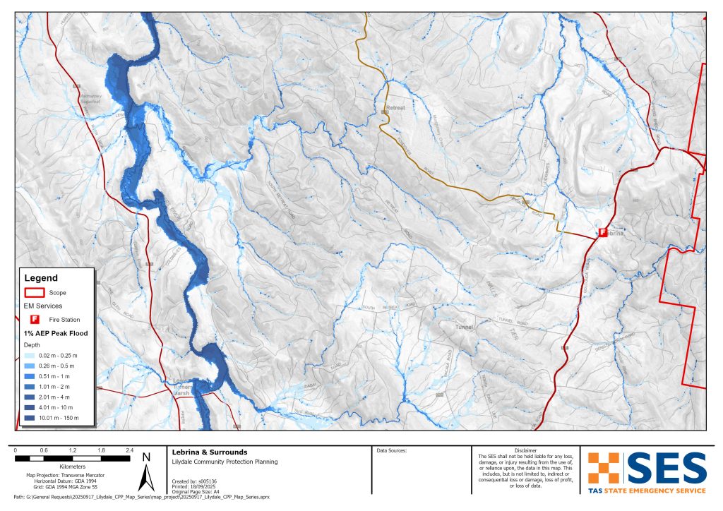
- Lebrina
- Retreat
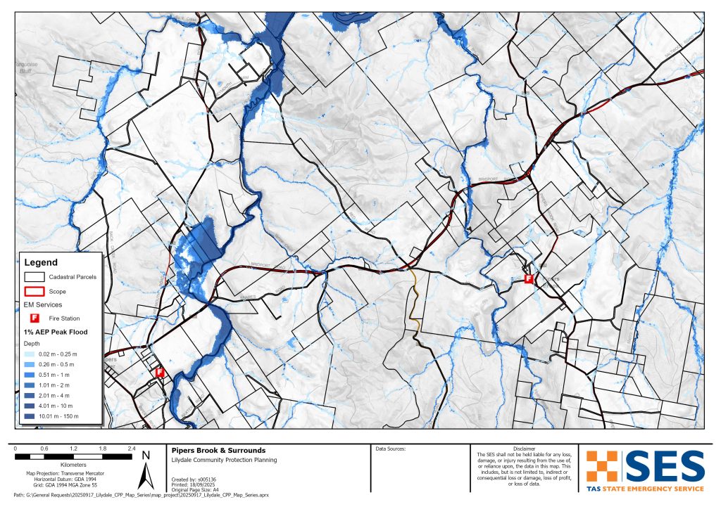
- Pipers Brook and
- Pipers River
- Bellingham
- Weymouth and
- Lulworth
地図をより詳細に表示するには、, タスマニア州洪水戦略マップをご覧ください.
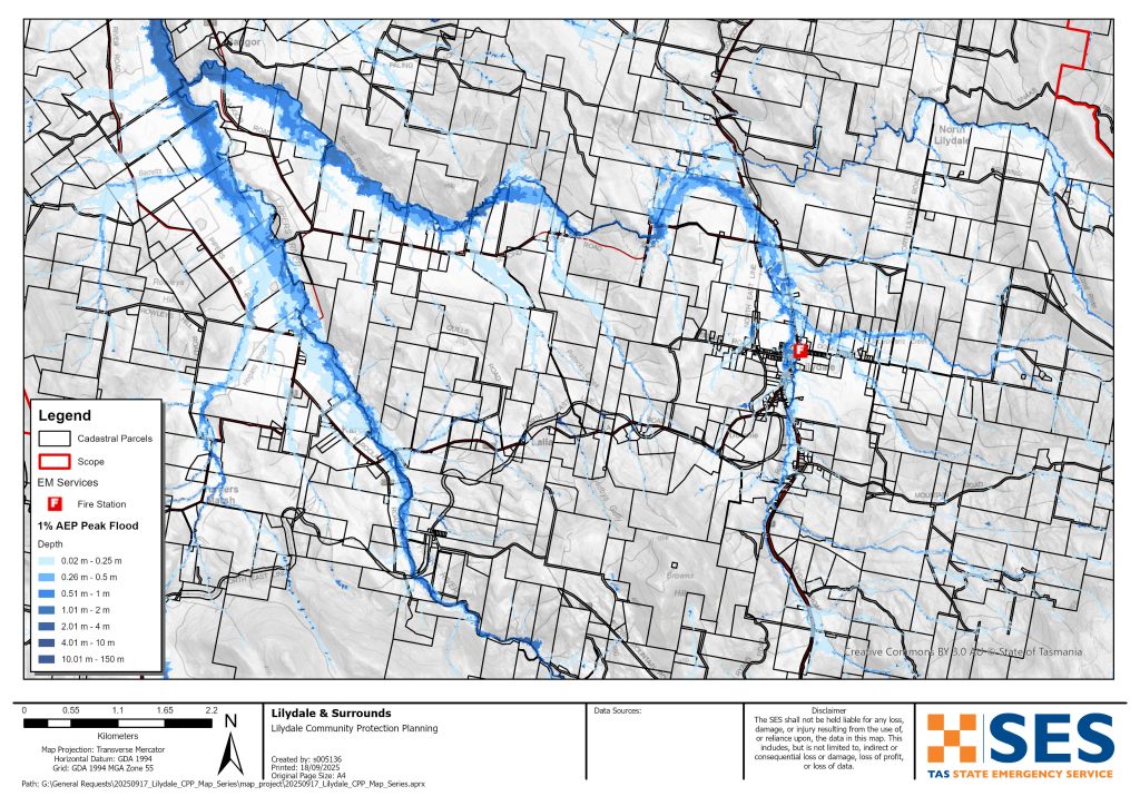
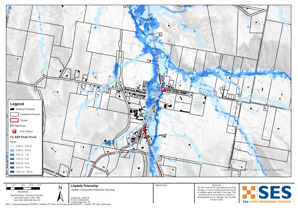
Parts of Lilydale township are prone to flash flooding from Rocky Creek after heavy rain, including Main Road. This flooding can be hard to predict. It can be difficult to give accurate and timely warnings.
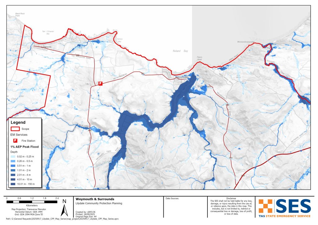
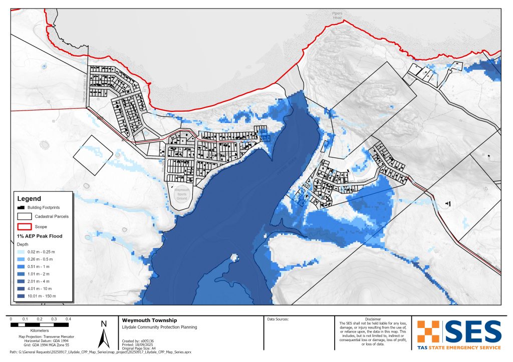
Parts of communities near the mouth of the Pipers River can also flood, particularly at high tide. This includes parts of
- Bellingham
- Weymouth, and
- Lulworth.
Some properties around Karoola could also flood.
Flooding can cut many roads around the area for a short time after heavy rain. This can make driving dangerous. Areas around the Pipers River can become isolated for short periods as low-lying roads flood. Even if your home is not inundated, you should be prepared for
- major traffic routes to be cut plus
- 停電や通信障害の可能性。.
洪水のリスクはありますか?
Areas around Lilydale and the Pipers River flooded in 1915, 1923, 1937, 1939, 2011, 2013, 2014 and 2016. Parts of Lilydale also flooded in October 2022.
どうすればいいですか?
- 自宅や事業所が浸水する可能性があるかどうか、地図で確認してください。.
- ご自宅または事業所を評価し、洪水による被害を最小限に抑える準備をしてください。.
- 洪水時に自宅、職場、学校に安全にたどり着けるか確認してください。.
- 自宅の緊急時計画を準備する。洪水による避難が必要かどうか考慮する。 緊急事態に備えよう– 個人および家庭向けの緊急事態への備えに関するガイド.
- If you are a primary producer, the Farm Flood Readiness Kit provides advice on preparing for a flood to help protect your business and stock.
- If you run a business or other organisation, check out the Tasmanian Government’s Emergency Ready Business tool online
- 孤立する可能性があり、サービスへのアクセスが必要な場合は、早期に避難する必要があるかもしれません。.
- 洪水のおそれのある地域でキャンプをする場合は、常に情報を入手し、洪水が予想される場合は早期に高台に避難するようにしてください。.
地図に示されているような、あるいはそれ以上にひどい洪水は再び起こるでしょう。二つの洪水は同じではありません。.
低地や水域の近くに住んでいる場合、家が浸水する可能性があります。家が安全でも、浸水地域を迂回する必要がある場合や、道路へのアクセスが遮断される場合があります。絶対に浸水した水の中を運転したり、入ったりしないでください。道路や橋が流されたり、安全でなくなったりする可能性があります。洪水時の移動は避けてください。.
何を知っておくべきかを知っておくことは、あなたの命を救い、財産を守るのに役立ちます。ホーム・エマージェンシー・プランを持つことは、準備の最善の方法の1つです。行動を起こす際の気象や降雨の引き金について決定してください。.
Bureau of Meteorology (BoM) Forecasts and Warnings
The Bureau issues a 洪水注意報 when predicted weather might cause floods in the area. A Flood Watch for this area would be a generalised one for 中央北部の河川流域 – a “heads up” early advice of forecast weather that may lead to flooding.
BoM does not issue formal flood level warnings for the Pipers River catchment. There are river level gauges on the Pipers River at
- Underwood, and
- Downstream of Yarrow Creek.
As the Pipers River is a short catchment, these gauges cannot give enough warning time.
It is best to act on BoM’s generalised flood watch warning, and observed rainfall, particularly at
- Mount Arthur Summit
- Pipers River Upstream of Yarrow Creek.
見る www.bom.gov.au/tas/flood/northern.shtml
SES will issue TasALERT warnings if predicted or observed rainfall could cause flooding in the area. However, sometimes it is not possible to issue those warnings in a timely manner as the area is prone to localised flash flooding that can happen quickly.
警告と重要な情報を理解する
周囲の状況に常に注意を払ってください。予報、観測、警報を定期的に確認してください。.
- お近くのABCラジオ局 または
 |
アドバイス(黄色) インシデントが発生しました。現時点では差し迫った危険はありません。状況が変わる可能性もありますので、随時最新情報をご確認ください。. |
 |
見て行動する(オレンジ) 脅威レベルが上昇しています。状況は変化しており、あなたとご家族を守るための行動を今すぐ開始する必要があります。 |
 |
緊急警報(赤) 緊急警報は最も高いレベルの警報です。危険な状態にあり、今すぐ行動を起こす必要があります。これ以上遅れると、命に危険が及びます。. |
 |
コミュニティアップデート(青): 特定のイベントやインシデントに関する、影響を受けた地域社会への具体的な情報と最新情報。. |
| インシデント(白) インシデントとは、緊急警報になる前の、事象の最初の発生のことです。インシデントが報告されるとすぐに、TasALERTはインシデントの種類や場所を含む基本的な情報を公開します。. |
洪水レベル
浸水被害は二つとして同じものはありませんが、以下に地域における浸水レベルごとの状況を説明します。ご自宅が浸水しなくても、アクセスについて考慮する必要があります。雨の強度、持続時間、事前の地面の湿り具合、そして雨が降る場所によって、様々な雨量で浸水が発生する可能性があります。.
Do not drive through flooded roads – it is dangerous. It is best to avoid travel during heavy rain. Most flooding in the area will only last for a short period after rain stops. Flooding around Pipers River is generally only for a few hours or less.
Minor and moderate flooding
Low lying parts of some roads around the area can flood for short periods of time after heavy rain. Depending where rain falls, main roads that could be flooded for a short time in low lying parts include:
- Bridport Road near Pipers River crossing, near Ferny Hill Road and near #2431
- Lilydale Road south of Garcias Road
- Underwood Road near Jones Road
- Bangor Road east from Pipers River Rd turnoff and Second River Crossing
- Lalla Road Pipers River crossing east of Karoola Road
- Second River Rd east of Merthyr Park and near Second River crossing.
Local roads most at risk include:
- Glenford Farm Road, Underwood, multiple places
- Baxters Road Pipers River Crossing
- Security Road Pipers River crossing
- Lewis Road, Pipers River
- Colgraves Road, Pipers River
- Weymouth Farm Road Back Creek crossing.
Other roads that may flood for a short period include
- Gargias Road, Underwood
- Collins Road, Karoola
- Karoola Road, Pipers River crossing
- Dicksons Road, Karoola
- Back Creek Road, Back Creek crossing
- Weymouth Rod Back Creek crossing
- Lees Road, Bangor, Third River crossing.
If rain is very heavy, some low-lying properties around Lilydale, Bellingham and Weymouth may flood. Check the flood maps for details. The following roads may also flood.
- Venn Road, Pipers Brook Pipers Brook crossing
- Langs Road, Pipers Brook, Pipers Brook crossing
- Goullees Road, Underwood, Butchers Creek crossing
- Gollconda Road north of Lilydale, several places
- North Lilydale Road, North Lilydale, Second River crossing.
- Doaks Road, Lilydale township
- Parrys Road, Pipers River
- South Retreat Rd, Retreat Montgomery Creek crossing, also west of Geiss Road
- Lyndon Avenue, Bellingham
- Mahnkens Road, North Lilydale
Flooding may also cut main roads to the south, east and west of this area. Flooding could isolate many properties and communities for a short time.
Major floodingThis area has more than a 2% chance of major flooding any year (annual exceedance probability (AEP)). A 2% AEP level event may be as a result of, for example:
- At Mount Arthur, about 57mm rain in 2 hours, or 94mm in 6 hours
- At Lilydale about 32mm rain in 1 hour, or 47mm in 3 hours
- At Pipers River township, 33mm rain in 1 hour or 53 mm in 3 hours
With this level of rainfall, or less
- Flooding will likely cut most roads around the area for short periods. Delay travel, if possible, for your safety.
- In Lilydale up to 45 properties may flood, including along
- Main Road/ Lilydale Road/ Golconda Road,
- Station Road
- Charob Avenue.
While in many cases this flooding will be shallow and below floor height, in some places water could be dangerously deep as well as fast moving. If your property floods and you have to leave quickly, move overland uphill to a safer place.
This flooding is likely to be for a short time. Follow TasALERT for information on evacuation options.
A flood that has a 1% chance of happening any year is also likely to impact low lying homes and other buildings in the following areas.
- Karoola – 4 properties along Pipers River Road, Karoola Road and Lalla RoadBellingham – 10 properties mostly in Lyndon Street, but also Albert Street and Clifford StreetWeymouth – 5 properties in Major Street or along the Esplanade
- Lulworth – low level overland may impact 2 properties
- Stormwater run-off (direct rainfall impacts from very heavy rain) can also affect some other properties.
- Coastal inundation, coastal erosion, plus high tides can also affect Bellingham, Weymouth and Lulworth.
If there is particularly heavy rain, there is likely to be an extra 12 properties flooded around Lilydale, Karoola, Bellingham and Wymouth (0.5% AEP). Flooding on roads listed is likely to be deeper and more dangerous.
Go to TasALERT.com or listen to ABC local radio for detailed up to date information and advice during heavy rainfall events.
リスクを知り、準備をして、可能な限りリスクを減らし、他者とつながり、警戒を怠らず、安全に行動しよう。.
洪水の前
緊急事態に備えよう – 個人および家庭向けの緊急事態への備えに関するガイド.
1. リスクを知る
タスマニアではしばしば洪水が発生し、広範囲にわたる甚大な被害をもたらすことがあります。過去200年間で、タスマニアでは洪水に関連した死者は78人にのぼります。このガイドは、お住まいの地域における洪水リスクを理解するのに役立つものです。.
2. ご家庭の準備
嵐や洪水に備えた緊急時対応計画を立てましょう
嵐や洪水が起きた時のことを考えておくということは、より準備ができていることであり、全員がより安全になるということです。家族全員が理解できる緊急時計画を立てましょう。計画を考えるためのチェックリストがありますので、をご覧ください。 緊急事態に備えよう – 個人および家庭向けの緊急事態への備えに関するガイド.
定期的に計画を確認し、世帯の全員で、洪水が発生した場合のシナリオを検討してテストしてください。.
緊急キットを準備する
準備完了
- 電池式ラジオと懐中電灯、予備電池
- 緊急時の計画など、重要な情報
- 緊急電話番号リスト
- 食べ物と水
- 救急箱
- ゴム製または丈夫な革製の手袋
必要に応じて荷造りする
- 暖かい服装、丈夫な靴またはブーツ
- 薬、眼鏡、またはその他の必需品
- 携帯電話と充電器
- ペットフードとその他の必要なもの
- 写真と思い出の品
- お金
- 重要書類、例えば
-
- 保険書類
-
- パスポートと
-
- 出生証明書
ラジオや懐中電灯の電池は定期的にテストしてください。.
3. 可能な限り、洪水によるリスクを減らしましょう
- 建物を購入、維持、開発する際は、嵐、洪水、その他の危険について考慮してください。.
- 自宅、事業所、または敷地内の電線近くにまたがっている木や枝を剪定または除去してください。.
- 雨どいと排水溝をきれいに掃除しておきましょう。.
4. 他の人とつながる
Know your neighbours and get involved in your community. A connected community is a safer and more resilient community in an emergency and can help everyone recover better afterwards. Check that family and neighbours are safe and aware of what’s happening.
その間
5. 最新の状態に保つ
周囲の状況に常に注意を払ってください。予報、観測、警報を定期的に確認してください。.
- お近くのABCラジオ局 または
- the 気象局 ウェブサイト.
6. 安全に行動する
- 子供たちを監督する。.
- 停電、断水、インターネット接続障害に備えましょう。.
- 緊急用キットの準備ができているか確認してください。.
- 排水溝など、浸水している場所には近づかないでください。. 決して 洪水の中を歩いたり、遊んだり、自転車や車で走ったりしないでください。水の下に何があるか、水深がどれくらいか、流れがどれほど速いかは、必ずしも目視では確認できません。わずか20センチほどの浅い場所でも、流れが速ければ流されて溺れる危険があります。洪水は危険です。.
自宅が浸水する可能性のある時期
- 家庭用品を高い場所に置いて、被害を最小限に抑えましょう。.
- 安全であれば、電気とガスを止めてください。.
- 下水が家に戻ってくるのを防ぐのに良い方法は、土のうをビニール袋に入れ、それをトイレに詰まって、排水溝やシンクを覆うことです。.
- 安全に脱出できるうちに立ち去れ。.
避難が必要な場合は
- SES / タスマニア警察からのアドバイスに従ってください。.
- 緊急キットを持って行ってください。.
- より安全な場所や避難所にいる友人や家族のところへ行ってください。.
- あなたの居場所を他の人に知らせてください。.
動物たちの世話をしてあげてください。
You are responsible for your animals in an emergency. If you have pets and other animals it will take you longer to evacuate in a flood or other emergency. Move livestock from flood prone areas well before flood waters may rise. For more information see
- the 一次生産者農業施設洪水対策ツールキット.
嵐の中や嵐の後には旅行を避けてください
- 観光はしないでください。観光客は緊急車両の通行を妨げ、事故の原因となります。.
- 危険にご注意ください(例:
-
- 道路上の水
-
- 損傷した電線
-
- 土砂崩れ
-
- 損傷した道路
-
- 倒木または屋根の鉄板。.
- 洪水の中を車で通行しないでください。洪水による死亡者や救助者のほとんどは、洪水の中を車で通行した人たちです。.
- 冠水していない道路では、速度を落として走行し、ヘッドライトを点灯させてください。.
その後
- ABCローカルラジオの最新情報、道路の再開、地域集会などの情報を引き続きお聞きください。.
- 自宅を出た場合は、SES(State Emergency Service)またはタスマニア警察が安全だと指示するまで帰宅しないでください。.
- 道路上の泥や瓦礫、道路・橋の損傷、清掃・修繕作業員などに注意してください。.
ご自宅が損傷した場合
- 被害状況を確認する際は、地面に留まってください。倒木、割れたガラス、屋根の破片など、危険な物には十分注意してください。.
- 丈夫なブーツ、手袋、保護衣を着用してください。.
- 浸水した建物内では、マッチやろうそくではなく、懐中電灯を使用してください。.
- 水道水が再び安全だと告げられるまで、飲む水はすべて煮沸してください。.
- Do not turn on it is tested by a licensed electrician or gas fitter for safety.
- 自宅が損傷し、他の場所にとどまる必要がある場合は、非常用キットとペットを連れて行ってください
- 安全であれば、損傷箇所の写真を撮って、保険会社に連絡してください。.
- 子供たちを監督する。.
- 近所の人が大丈夫か確認してください。.
詳細については、以下をご覧ください www.ses.tas.gov.au
最新情報とさらなる情報
Current warnings – TasALERT.com
Emergency Broadcasters – お近くのABCラジオ局
TASSES Social Media – facebook.com/sestasmania
洪水緊急事態への備え ses.tas.gov.au/flood-plan/
ナショナルリレーサービス (NRS) relayservice.gov.au
Local Emergency Broadcasters ABC 91.7FM
City of Launceston launceston.tas.gov.au 6323 3000
George Town Council georgetown.tas.gov.au
免責事項
The maps show potential flooding risks from consistent levels of rainfall across catchments, such as a 1% Annual Exceedance Probability (AEP). In flooding events, rainfall is likely to be more inconsistent across a catchment, so these flood maps should be considered indicative only. The mapped areas of flood risk show higher probability of inundation. Other areas have lower probability of flooding, but in severe and rare events (rarer than 1%AEP), other lower areas may be also at risk of inundation.
本ガイドに記載されている情報は、発行時点での最新情報です。掲載データの有効性および正確性を確保するために万全を期しておりますが、州緊急事態局は、データの誤りや欠落について責任を負いません。標準規定をご参照ください。 タスマニア州政府の著作権および免責事項に関する声明 詳細については.
