莉莉戴爾 – 派珀斯河洪災指南
Version 0.2 Draft for community input – Download PDF version
派珀斯河及其支流沿岸社區的河岸氾濫和山洪暴發資訊
- 莉莉戴爾
- 安德伍德
- 卡鲁拉
- 拉拉
- 特納斯沼澤
- 下特納斯沼澤
- 班戈
- 北部莉莉谷
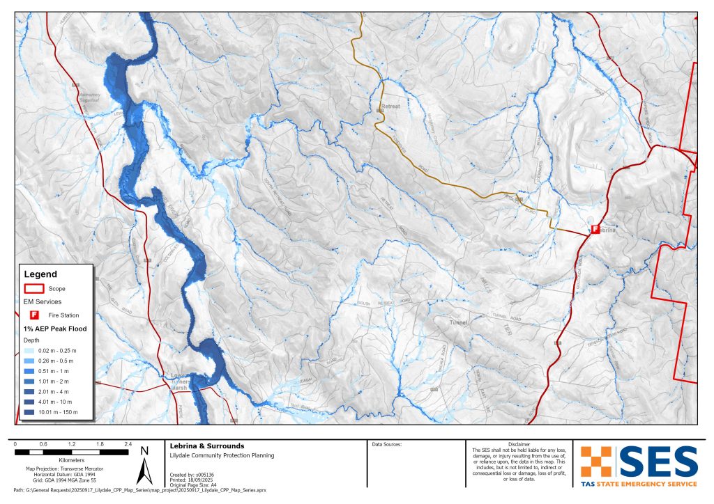
- 勒布里纳
- 撤退
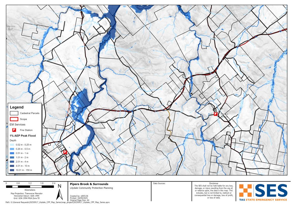
- 派珀斯布鲁克和
- 派珀斯河
- 貝靈漢
- 韋茅斯和
- 盧沃思
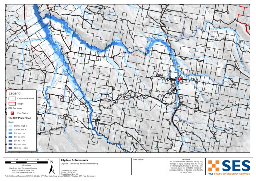
若要更詳細地查看地圖,, 查看塔斯馬尼亞策略性洪水圖.
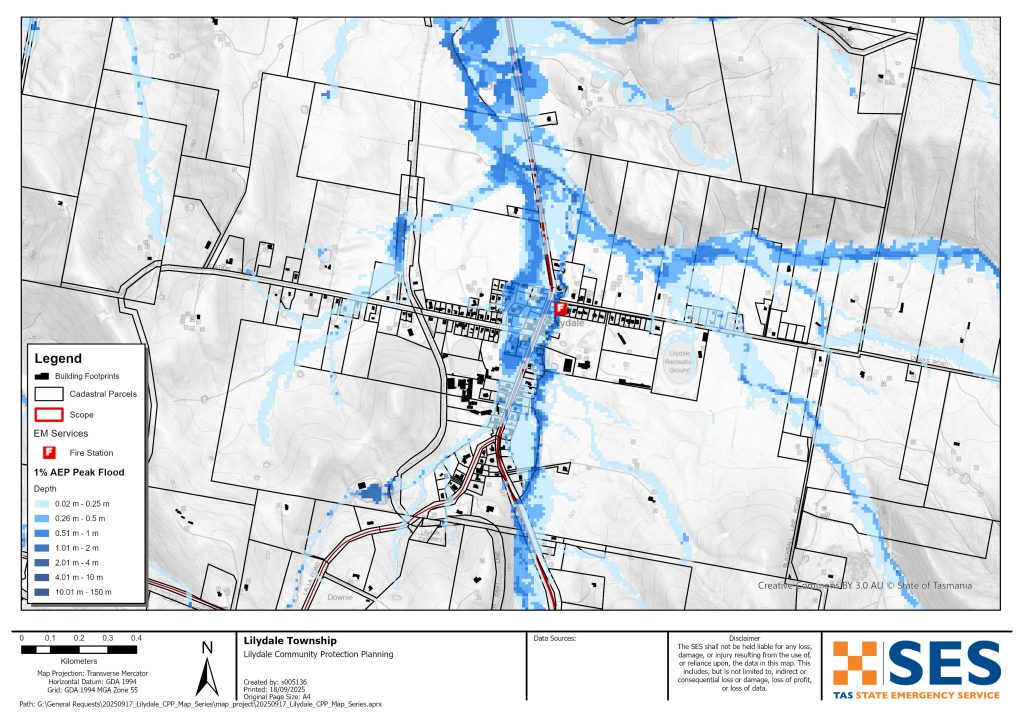
Lilydale鎮的部分地區,包括Main Road,在豪雨後容易遭受Rocky Creek的暴洪侵襲。這種洪災難以預測,並且難以及時發出準確的警報。.
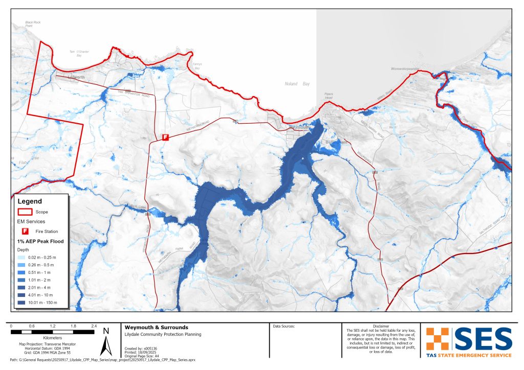
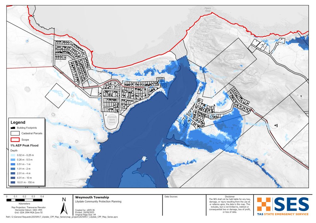
派珀斯河河口附近的社區部分地區也可能發生洪水,尤其是在漲潮時。這包括
- 貝靈漢
- 韋茅斯,和
- 盧斯威爾.
卡魯拉(Karoola)周邊的一些房產也可能發生洪水。.
大雨過後,許多當地道路可能暫時中斷。這會導致駕駛危險。派波斯河周邊地區在低窪道路淹水時,可能會短暫變得孤立。即使您的家沒有被淹沒,您也應該為以下情況做好準備:
- 主要交通路線將被中斷,外加
- 潛在的電力和電信中斷。.
您有洪水風險嗎?
1915、1923、1937、1939、2011、2013、2014 和 2016 年,Lilydale 周邊及 Pipers River 地區發生洪水。Lilydale 部分地區亦於 2022 年 10 月發生洪水。.
我應該做什麼?
- 檢查地圖,看看您的住宅或企業是否可能遭受洪水侵襲。.
- 評估您的住家或公司,並做好準備以盡量減少潛在的洪水損害。.
- 檢查您是否能在洪水期間安全地抵達家中、工作地點或學校。.
- 準備一份居家緊急計畫。考慮是否需要在大水來臨前撤離。請參閱 為緊急情況做好準備– 為個人和家庭準備應急措施的指南。.
- If you are a primary producer, the Farm Flood Readiness Kit provides advice on preparing for a flood to help protect your business and stock.
- If you run a business or other organisation, check out the Tasmanian Government’s Emergency Ready Business tool online
- 如果你可能被隔離且必須取得服務,你可能需要提早撤離。.
- 如果你在容易發生洪水的地區露營,請確保隨時掌握最新資訊,並且在可能發生洪水時及早移往高處。.
像地圖所示的洪水,或更糟的洪水,將會再次發生。沒有兩次洪水是相同的。.
如果您居住在低窪地區或靠近水道,您的房屋可能會被淹沒。即使您的住所安全,您也可能需要繞過淹水地區,或者您的道路通行可能會被阻斷。切勿駕車進入或身處洪水之中。道路和橋樑可能會被沖毀或不安全。洪水期間請避免出行。.
知道該怎麼做可以拯救你的生命並保護你的財產。制定家庭緊急計畫是最好的準備方法之一。決定天氣和降雨的觸發條件,以便採取行動。.
Bureau of Meteorology (BoM) Forecasts and Warnings
該局發布一份 洪水注意 當預測天氣可能導致該地區發生洪水時。該地區的洪水警戒將是廣泛的 中部北部河流流域 – 提前「預警」預報可能導致淹水的氣象。.
BoM does not issue formal flood level warnings for the Pipers River catchment. There are river level gauges on the Pipers River at
- 安德伍德,和
- 雅罗溪下游.
由於派珀斯河集水區狹小,這些水位計無法提供足夠的預警時間。.
最好根據 BOM 的總體洪水警戒預警和觀測到的降雨量採取行動,尤其是在
- 亞瑟峰
- 派珀斯河,在亞羅溪上游。.
看 www.bom.gov.au/tas/flood/northern.shtml
SES will issue TasALERT warnings if predicted or observed rainfall could cause flooding in the area. However, sometimes it is not possible to issue those warnings in a timely manner as the area is prone to localised flash flooding that can happen quickly.
了解警告和關鍵資訊
隨時留意周遭狀況。定期查看天氣預報、觀測數據和警報。.
 |
建議 (黃色): 已發生事件。目前沒有立即危險。請隨時更新最新情況,以防局勢變動。. |
 |
觀察與行動(橘色): 威脅等級升高。情勢正在改變,您現在就必須採取行動保護您和您的家人。 |
 |
緊急警告(紅色): 緊急警報為最高級別的警報。您可能身處危險之中,需要立即採取行動。任何延誤都可能危及您的生命。. |
 |
社群更新(藍色): 針對特定事件或事故,向受影響社群提供的具體資訊和最新消息。. |
| 事件(白色): 事件是緊急警報發布前的初步發生。一旦事件被報告,TasALERT 就會發布基本資訊,包括事件的類型和地點。. |
洪水水位
雖然沒有兩次洪水是完全相同的,但以下描述了該地區在不同洪水水位下可能發生的情況。即使您的房產沒有被淹沒,您也需要考慮進出問題。不同程度的降雨都會導致洪水,這取決於降雨的強度、持續時間,以及事先的土壤濕度以及降雨發生的地點。.
請勿駕車行駛於淹水路段,這非常危險。t is best to avoid travel during heavy rain. Most flooding in the area will only last for a short period after rain stops. Flooding around Pipers River is generally only for a few hours or less.
局部及中度氾濫
Low lying parts of some roads around the area can flood for short periods of time after heavy rain. Depending where rain falls, main roads that could be flooded for a short time in low lying parts include:
- 百帕斯河(Pipers River)過渡點附近的布里德波特路(Bridport Road),靠近費爾尼希爾路(Ferny Hill Road)以及#2431。
- Lilydale Road 往 Garcias Road 以南
- 安德伍德路靠近瓊斯路
- 班戈路(Bangor Road)東至派珀斯河路(Pipers River Rd)轉彎處和第二河渡口(Second River Crossing)
- 拉拉路,派珀斯河,卡羅拉路以東的渡口
- 第二河路,位於梅斯 tér 公園東邊,靠近第二河過道。.
當地最有可能受影響的道路包括:
- 格蘭福德農莊路,安德伍德,多個地點
- 巴克斯特路河流渡口
- 安全路口 敲笛者 河流過境
- 路易士路,派珀斯河
- 科爾格雷夫路,派珀斯河
- 威茅斯農場路後溪通道。.
其他可能在短時間內淹水的道路包括
- 加蓋斯路,安德伍德
- 卡鲁拉柯林斯路
- 卡羅拉路,派珀斯河過境點
- 迪克森路,卡羅拉
- 後溪路,後溪渡口
- 韋茅斯羅德巴克溪過河點
- 利斯路,班戈,第三河過境點。.
如果雨勢非常猛烈,Lilydale、Bellingham 和 Weymouth 周圍的低窪地區可能會發生洪水。請查看淹水地圖了解詳情。以下道路也可能發生淹水。.
- 文恩路,派波思布魯克 派波思布魯克交叉路口
- 蘭斯路,派珀斯布魯克,派珀斯布魯克過境點
- 高里斯路,安德伍德,屠夫溪過境點
- 戈爾孔達路,位於莉莉戴爾以北,有幾個地方
- 北利利代爾路、北利利代爾、第二次過河。.
- 杜克斯路,莉莉戴爾鎮
- 派瑞斯路,派波斯河
- 南退隱路,退隱蒙哥馬利溪交叉處,亦在蓋斯路以西
- 林登大道,貝靈漢
- 馬肯斯路,北莉莉戴爾
洪水也可能切斷該區域的南部、東部和西部的主要道路。洪水可能會讓許多房地產和社區在短時間內與外界隔絕。.
嚴重洪水此區域每年有超過 2% 的機率發生嚴重洪水(年度超額機率 (AEP))。2% 的 AEP 等級事件可能因此發生,例如:
- 在亞瑟山,兩小時約有 57 毫米的降雨,或六小時約有 94 毫米的降雨
- 在 Lilydale 大約一小時內降雨 32 毫米,或三小時內降雨 47 毫米
- 在派普斯河鎮,一小時降雨量為 33 毫米,或三小時降雨量為 53 毫米
以這樣的降雨量,或更少
- 洪水可能會暫時中斷該地區的大部分道路。為您的安全起見,請盡量延遲出行。.
- 在 Lilydale,高達 45 處房產恐有淹水風險,其中包含沿著
- 主幹道/莉莉戴爾路/戈爾貢達路,
- 車站路
- 夏洛街.
儘管大多數情況下洪水較淺,低於樓層高度,但在某些地方,水可能又深又急。如果您的房屋淹水且您必須迅速離開,請往高處陸地移動到更安全的地方。.
這次洪水可能只會持續很短時間。請關注 TasALERT 以獲取有關撤離選項的資訊。.
% 每年都有可能發生的洪水,也很可能影響下列地區的低窪房屋和其他建築物。.
- Karoola – 派波斯河道(Pipers River Road)、卡魯拉道(Karoola Road)及拉拉道(Lalla Road)沿線共有 4 處房產。 Bellingham – 位於林登街(Lyndon Street)的大部分房產,以及阿爾伯特街(Albert Street)和克利福德街(Clifford Street)共有 10 處房產。 Weymouth – 位於梅傑街(Major Street)或海濱大道(Esplanade)沿線共有 5 處房產。
- 盧斯沃思 – 低空越野飛行可能影響兩處房產
- 雨水逕流(極大降雨的直接降雨影響)也會影響其他一些物業。.
- 沿海洪水、海岸侵蝕再加上漲潮也會影響貝靈漢、韋茅斯和盧爾沃斯。.
若遇上特別大雨,Lilydale(莉莉黛爾)、Karoola(卡魯拉)、Bellingham(貝靈漢)和Wymouth(懷茅斯)一帶預計會有額外12處物業受淹(% AEP)。路面淹水預計會更深,更危險。.
Go to TasALERT.com or listen to ABC local radio for detailed up to date information and advice during heavy rainfall events.
了解你的風險,做好準備,盡可能降低風險,與他人聯繫,保持警惕並安全行動。.
洪水之前
為緊急情況做好準備 – 為個人和家庭準備應急措施的指南。.
1. 認識你的風險
塔斯馬尼亞經常發生洪水,可能造成廣泛且嚴重的損害。在過去 200 年裡,塔斯馬尼亞有 78 人死於與洪水相關的事件。本指南旨在幫助您了解您所在地區的洪水風險。.
2. 準備您的家戶
制定包含風暴和洪水應變計畫
思考一下在風暴或洪水來襲時你會怎麼做,意味著你準備得更充分,每個人都會更安全。制定一個家庭中的每個人都理解的緊急計畫。有檢查表可以幫助你思考你的計畫——請參閱 為緊急情況做好準備 – 為個人和家庭準備應急措施的指南。.
定期檢查您的計劃,並讓家中的每個人都設想一次可能影響您家的洪水情況來進行測試。.
準備一個緊急救生包
準備好了
- 電池供電的收音機和手電筒,備用電池
- 重要資訊,例如您的緊急應變計畫
- 緊急電話號碼列表
- 食物和水
- 急救箱
- 橡膠手套或堅固的皮革手套
需要時打包
- 暖和的衣服、結實的鞋子或靴子
- 藥品、眼鏡或其他必需品
- 手機和充電器
- 寵物食品和他們需要的任何其他東西
- 照片和特別紀念品
- 錢
- 重要文件,例如
-
- 保險文件
-
- 護照與
-
- 出生證明
定期測試收音機和手電筒的電池。.
3. 在可能的情況下,降低您遭受洪水侵襲的風險
- 在購買、維護或開發房地產時,請考慮風暴、洪水和其他災害。.
- 修剪或移除您家中、商家或您家附近有電力線的樹木和樹枝。.
- 保持您的排水溝和排水管暢通。.
4. 與他人建立聯繫
Know your neighbours and get involved in your community. A connected community is a safer and more resilient community in an emergency and can help everyone recover better afterwards. Check that family and neighbours are safe and aware of what’s happening.
期間
5. 保持更新
隨時留意周遭狀況。定期查看天氣預報、觀測數據和警報。.
- 這 氣象局 網站.
6. 保持安全
- 監督兒童.
- 為可能的停電、停水或斷網做好準備。.
- 檢查您的緊急救助包是否已準備就緒。.
- 切勿靠近淹水區域,例如排水溝。. 永不 在洪水中有行走、玩耍、骑行或开车。你無法確定水下有什麼,或水有多深、流速有多快。20公分的湍急的洪水就很容易將人沖走並淹死。洪水可能很危險。.
您的房屋可能發生淹水時
- 將家居物品放在高處,以盡量減少潛在損壞。.
- 如果安全的話,請關閉水電和瓦斯。.
- 一種防止污水倒灌回屋內的好方法是將沙包放入塑膠袋中,然後用它們來堵塞馬桶、蓋住排水孔和水槽。.
- 趁你還能安全脫困時趕快離開。.
如果你需要疏散
- 請遵循 SES / 塔斯馬尼亞警方的建議。.
- 帶上你的緊急求生包。.
- 前往朋友或家人較安全的地方,或前往疏散中心。.
- 讓別人知道你去了哪裡。.
照顧好你的動物
You are responsible for your animals in an emergency. If you have pets and other animals it will take you longer to evacuate in a flood or other emergency. Move livestock from flood prone areas well before flood waters may rise. For more information see
請避免在風暴期間和風暴之後旅行
- 不要去觀光。觀光客會延誤緊急服務並造成事故。.
- 注意危險,例如
-
- 路面积水
-
- 損壞的電力線
-
- 山崩
-
- 損壞的道路
-
- 倒下的樹木或屋頂鐵片。.
- 切勿駕車通過淹水區域。洪水中的大多數死亡和救援事件都與駕車通過淹水區域有關。.
- 緩慢行駛,並在不受洪水影響的道路上打開頭燈。.
之後
- 請持續收聽 ABC 地方電台的最新消息、道路重新開放、社區會議等資訊。.
- 如果您離開家,請勿在聯邦緊急事務局 (SES) 或塔斯馬尼亞警方告知您安全之前回家。.
- 注意道路上的危險,例如路面上的泥沙或碎屑、道路/橋樑損壞以及正在進行清理和修復工作的工人。.
如果您的房屋已受損
- 在檢查損壞時,請待在地面。小心掉落的樹木、碎玻璃、鬆動的屋頂或其它危險物品。.
- 穿著堅固的靴子、手套和防護服。.
- 請使用手電筒,切勿在受洪水影響的建築物內使用火柴或蠟燭。.
- 將所有飲用水煮沸,直到被告知自來水再次安全為止。.
- Do not turn on it is tested by a licensed electrician or gas fitter for safety.
- 如果您的房屋受損,需要暫時住在其他地方,請攜帶您的緊急應變包和寵物一同前往。
- 如安全,請拍攝任何損壞的照片,並聯繫您的保險公司。.
- 監督兒童.
- 檢查鄰居是否安好。.
如需更多資訊,請前往 www.ses.tas.gov.au
保持獲取最新資訊及更多詳盡資料
Current warnings – TasALERT.com
Emergency Broadcasters – 您當地的 ABC 電台
TASSES Social Media – facebook.com/sestasmania
為洪水緊急情況做準備 ses.tas.gov.au/flood-plan/
國家轉接服務 (NRS) relayservice.gov.au
Local Emergency Broadcasters ABC 91.7FM
朗塞斯頓市 launceston.tas.gov.au 6323 3000
喬治鎮理事會 georgetown.tas.gov.au
免責聲明
The maps show potential flooding risks from consistent levels of rainfall across catchments, such as a 1% Annual Exceedance Probability (AEP). In flooding events, rainfall is likely to be more inconsistent across a catchment, so these flood maps should be considered indicative only. The mapped areas of flood risk show higher probability of inundation. Other areas have lower probability of flooding, but in severe and rare events (rarer than 1%AEP), other lower areas may be also at risk of inundation.
本指南中的資訊在出版時是最新資料。儘管已盡一切努力確保所呈現數據的有效性和準確性,但州緊急服務部門不對數據錯誤或遺漏負責。請參閱標準 塔斯馬尼亞州政府的版權與免責聲明 更多詳情.
