莉莉代尔 – 派珀斯河洪水指南
Version 0.2 Draft for community input – Download PDF version
Riverine flooding and flash flooding information for communities along the Pipers River and its tributaries
- Lilydale
- Underwood
- Karoola
- Lalla
- Turners Marsh
- Lower Turners Marsh
- Bangor
- North Lilydale
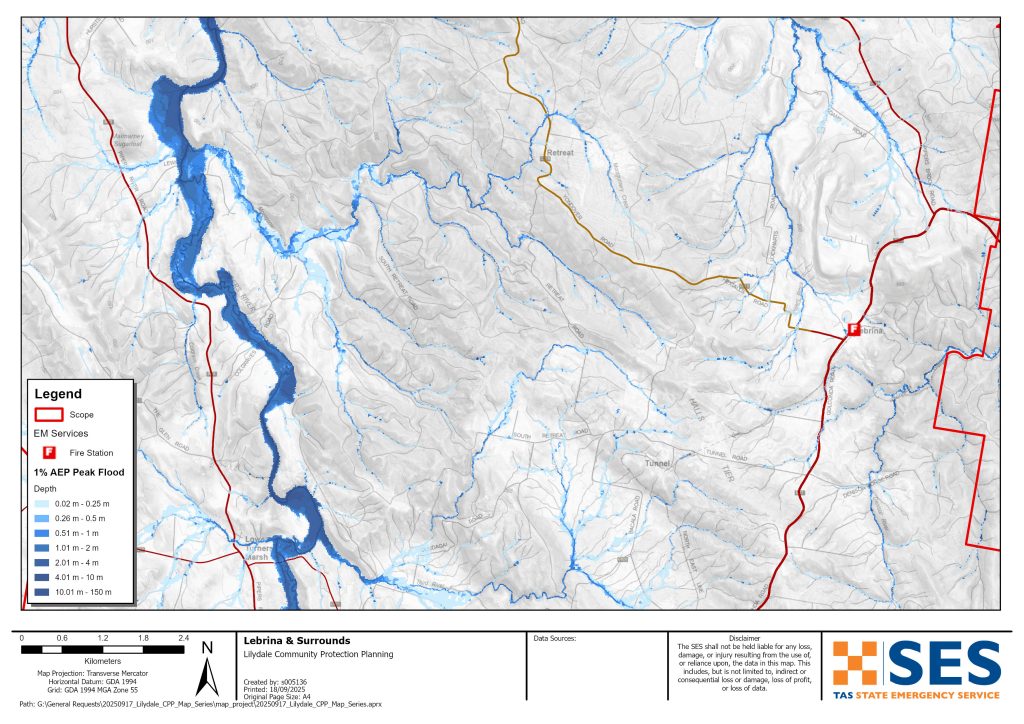
- Lebrina
- Retreat
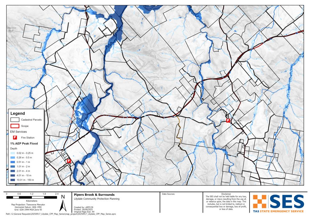
- Pipers Brook and
- Pipers River
- Bellingham
- Weymouth and
- Lulworth
要更详细地查看地图,, 查看塔斯马尼亚战略洪水地图.
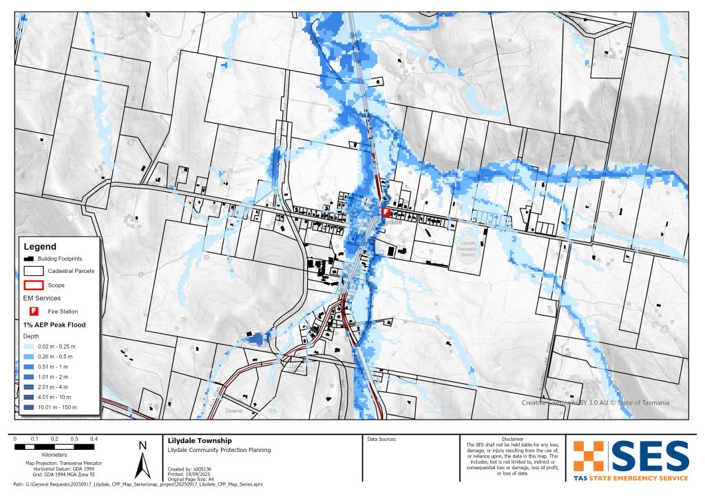
Parts of Lilydale township are prone to flash flooding from Rocky Creek after heavy rain, including Main Road. This flooding can be hard to predict. It can be difficult to give accurate and timely warnings.
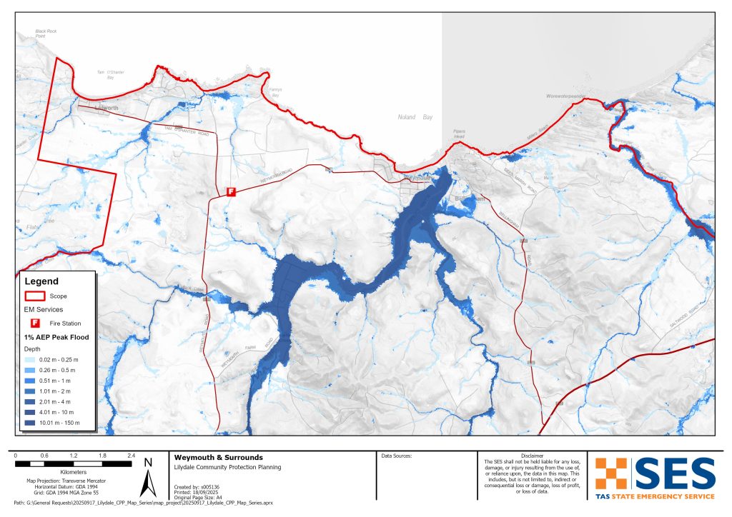
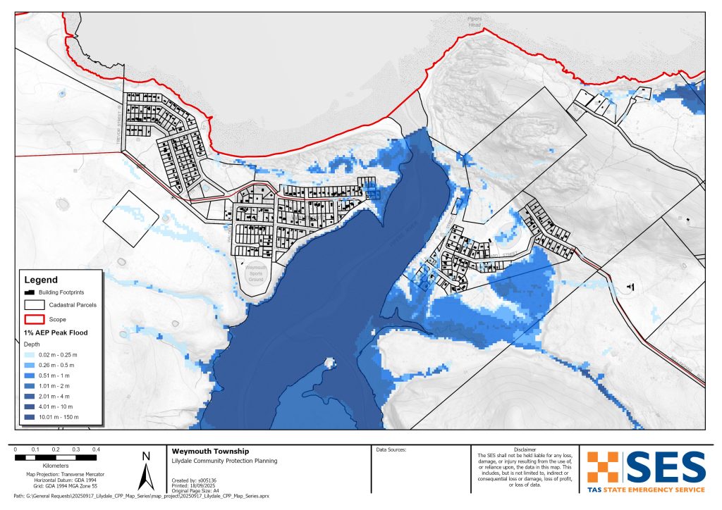
Parts of communities near the mouth of the Pipers River can also flood, particularly at high tide. This includes parts of
- Bellingham
- Weymouth, and
- Lulworth.
Some properties around Karoola could also flood.
Flooding can cut many roads around the area for a short time after heavy rain. This can make driving dangerous. Areas around the Pipers River can become isolated for short periods as low-lying roads flood. Even if your home is not inundated, you should be prepared for
- major traffic routes to be cut plus
- 潜在的电力和电信中断。.
您有洪水风险吗?
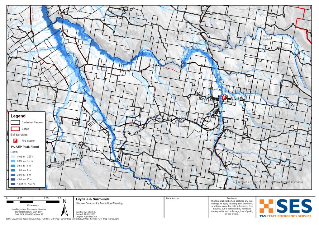
Areas around Lilydale and the Pipers River flooded in 1915, 1923, 1937, 1939, 2011, 2013, 2014 and 2016. Parts of Lilydale also flooded in October 2022.
我应该怎么做?
- 查看地图,了解您的住宅或商家是否可能发生洪水。.
- 评估您的住宅或企业,并做好准备以最大程度地减少潜在的洪水损害。.
- 洪水期间,检查您是否能够安全地到达家、工作地点或学校。.
- 准备家庭应急计划。考虑是否需要在洪水来临前撤离。参见 做好应急准备– 个人和家庭应急准备指南。.
- 如果你是初级生产者, 农场防洪应急包 为洪水提供准备建议,以帮助保护您的企业和库存。.
- If you run a business or other organisation, check out the Tasmanian Government’s Emergency Ready Business tool online
- 如果您可能被隔离并且必须获得服务,您可能需要提早撤离。.
- 如果您在易发洪灾的地区露营,请务必随时了解情况,如果可能发生洪水,请及早转移到高地。.
像地图上显示的洪水,或者更糟糕的情况,将会再次发生。没有两次洪水是相同的。.
如果您住在低洼地区或靠近水道,您的房屋可能会被淹没。即使您的家是安全的,您也可能需要绕过洪水地区,或者您的道路通行可能会受到阻碍。切勿驾车进入或进入洪水区域。道路和桥梁可能被冲毁或不安全。请避免在洪水期间出行。.
了解该怎么做可以拯救你的生命并帮助保护你的财产。制定家庭应急计划是准备工作的最佳方法之一。决定天气和降雨触发条件,以便知道何时采取行动。.
Bureau of Meteorology (BoM) Forecasts and Warnings
The Bureau issues a 洪水观察 when predicted weather might cause floods in the area. A Flood Watch for this area would be a generalised one for 中部北方河流流域 – a “heads up” early advice of forecast weather that may lead to flooding.
BoM does not issue formal flood level warnings for the Pipers River catchment. There are river level gauges on the Pipers River at
- Underwood, and
- Downstream of Yarrow Creek.
As the Pipers River is a short catchment, these gauges cannot give enough warning time.
It is best to act on BoM’s generalised flood watch warning, and observed rainfall, particularly at
- Mount Arthur Summit
- Pipers River Upstream of Yarrow Creek.
看 www.bom.gov.au/tas/flood/northern.shtml
SES will issue TasALERT warnings if predicted or observed rainfall could cause flooding in the area. However, sometimes it is not possible to issue those warnings in a timely manner as the area is prone to localised flash flooding that can happen quickly.
理解警告和关键信息
留意周围发生的事情。定期查看预报、观测和警报。.
 |
建议 (黄色): 事件已发生。无即时危险。请保持关注,以防情况发生变化。. |
 |
观察并行动(橙色): 威胁级别有所提高。情况正在变化,您需要立即开始采取行动来保护您和您的家人 |
 |
紧急警报(红色): 紧急警报是最高级别的警报。您可能面临危险,需要立即采取行动。任何耽搁都可能危及您的生命。. |
 |
社区更新(蓝色): 关于特定事件或事件,受影响社区的具体信息和最新动态。. |
| 事件(白色): 事件是指在成为紧急警报之前的初次发生。一旦报告了事件,TasALERT 就会发布基本信息,包括事件的类型和地点。. |
洪水水位
虽然没有两次洪水是相同的,但以下描述了该地区不同洪水级别的情况。即使您的财产没有被淹没,您也需要考虑通行问题。不同强度的降雨,持续时间和地面事先的湿润程度以及降雨地点都会导致洪水。.
Do not drive through flooded roads – it is dangerous. It is best to avoid travel during heavy rain. Most flooding in the area will only last for a short period after rain stops. Flooding around Pipers River is generally only for a few hours or less.
Minor and moderate flooding
Low lying parts of some roads around the area can flood for short periods of time after heavy rain. Depending where rain falls, main roads that could be flooded for a short time in low lying parts include:
- Bridport Road near Pipers River crossing, near Ferny Hill Road and near #2431
- Lilydale Road south of Garcias Road
- Underwood Road near Jones Road
- Bangor Road east from Pipers River Rd turnoff and Second River Crossing
- Lalla Road Pipers River crossing east of Karoola Road
- Second River Rd east of Merthyr Park and near Second River crossing.
Local roads most at risk include:
- Glenford Farm Road, Underwood, multiple places
- Baxters Road Pipers River Crossing
- Security Road Pipers River crossing
- Lewis Road, Pipers River
- Colgraves Road, Pipers River
- Weymouth Farm Road Back Creek crossing.
Other roads that may flood for a short period include
- Gargias Road, Underwood
- Collins Road, Karoola
- Karoola Road, Pipers River crossing
- Dicksons Road, Karoola
- Back Creek Road, Back Creek crossing
- Weymouth Rod Back Creek crossing
- Lees Road, Bangor, Third River crossing.
If rain is very heavy, some low-lying properties around Lilydale, Bellingham and Weymouth may flood. Check the flood maps for details. The following roads may also flood.
- Venn Road, Pipers Brook Pipers Brook crossing
- Langs Road, Pipers Brook, Pipers Brook crossing
- Goullees Road, Underwood, Butchers Creek crossing
- Gollconda Road north of Lilydale, several places
- North Lilydale Road, North Lilydale, Second River crossing.
- Doaks Road, Lilydale township
- Parrys Road, Pipers River
- South Retreat Rd, Retreat Montgomery Creek crossing, also west of Geiss Road
- Lyndon Avenue, Bellingham
- Mahnkens Road, North Lilydale
Flooding may also cut main roads to the south, east and west of this area. Flooding could isolate many properties and communities for a short time.
Major floodingThis area has more than a 2% chance of major flooding any year (annual exceedance probability (AEP)). A 2% AEP level event may be as a result of, for example:
- At Mount Arthur, about 57mm rain in 2 hours, or 94mm in 6 hours
- At Lilydale about 32mm rain in 1 hour, or 47mm in 3 hours
- At Pipers River township, 33mm rain in 1 hour or 53 mm in 3 hours
With this level of rainfall, or less
- Flooding will likely cut most roads around the area for short periods. Delay travel, if possible, for your safety.
- In Lilydale up to 45 properties may flood, including along
- Main Road/ Lilydale Road/ Golconda Road,
- 车站路
- Charob Avenue.
While in many cases this flooding will be shallow and below floor height, in some places water could be dangerously deep as well as fast moving. If your property floods and you have to leave quickly, move overland uphill to a safer place.
This flooding is likely to be for a short time. Follow TasALERT for information on evacuation options.
A flood that has a 1% chance of happening any year is also likely to impact low lying homes and other buildings in the following areas.
- Karoola – 4 properties along Pipers River Road, Karoola Road and Lalla RoadBellingham – 10 properties mostly in Lyndon Street, but also Albert Street and Clifford StreetWeymouth – 5 properties in Major Street or along the Esplanade
- Lulworth – low level overland may impact 2 properties
- Stormwater run-off (direct rainfall impacts from very heavy rain) can also affect some other properties.
- Coastal inundation, coastal erosion, plus high tides can also affect Bellingham, Weymouth and Lulworth.
If there is particularly heavy rain, there is likely to be an extra 12 properties flooded around Lilydale, Karoola, Bellingham and Wymouth (0.5% AEP). Flooding on roads listed is likely to be deeper and more dangerous.
Go to TasALERT.com or listen to ABC local radio for detailed up to date information and advice during heavy rainfall events.
了解风险,做好准备,尽可能降低风险,与他人联系,保持警惕,并安全行事。.
洪水之前
做好应急准备 – 个人和家庭应急准备指南。.
了解您的风险
塔斯马尼亚州经常发生洪水,可能造成广泛而重大的损失。在过去的 200 年里,塔斯马尼亚州有 78 人死于与洪水有关的事故。本指南旨在帮助您了解您所在地区的洪水风险。.
2. 准备您的家庭
制定涵盖风暴和洪水的应急计划
考虑一下在风暴或洪水来临时你会怎么做,这意味着你会有更好的准备,每个人都会更安全。制定一个你的家庭成员都明白的应急计划。有一些清单可以帮助你完善你的计划——请看 做好应急准备 – 个人和家庭应急准备指南。.
定期检查您的计划,并让家中的每一位成员都模拟可能影响您家庭的洪水场景进行演练。.
准备一个应急包
准备好了
- 电池供电的收音机和手电筒,备用电池
- 重要信息,例如您的应急计划
- 紧急电话号码列表
- 食物和水
- 急救箱
- 橡胶或结实的皮革手套
视情况打包
- 保暖衣物、结实的鞋子或靴子
- 药品、眼镜或其他必需品
- 手机和充电器
- 宠物食品以及它们所需的其他任何物品
- 照片和特别的纪念品
- 钱
- 重要文件,例如
-
- 保险单据
-
- 护照和
-
- 出生证明
定期测试收音机和手电筒里的电池。.
3. 尽可能降低洪水风险
- 在购买、维护或开发房产时,请考虑风暴、洪水和其他危险。.
- 修剪或移除您家中、商铺上方或您物业附近电线上方的树木和树枝。.
- 保持雨水槽和排水沟畅通。.
4. 与他人联系
Know your neighbours and get involved in your community. A connected community is a safer and more resilient community in an emergency and can help everyone recover better afterwards. Check that family and neighbours are safe and aware of what’s happening.
于
5. 保持更新
留意周围发生的事情。定期查看预报、观测和警报。.
- 这 气象局 网站.
6. 确保安全
- 看管好孩子。.
- 为应对可能的电力、供水或网络中断做好准备。.
- 检查您的应急包是否已准备好。.
- 避开积水区域,如排水沟。. 永不 在洪水期间徒步、玩耍、骑车或驾车。您无法分辨水下有什么,也无法判断水深或水流速度。在仅 20 厘米的快速流动的水中,很容易被冲走并溺水。洪水可能很危险。.
当地面发生洪水时
- 将家用物品放在高处以最大程度地减少可能的损坏。.
- 如果安全的话,请关闭水电煤气。.
- 一种防止污水倒灌回家的好方法是将沙袋放入塑料袋中,然后用它们堵住马桶、覆盖排水管和水槽。.
- 趁还能安全离开就走。.
如果您需要撤离
- 遵循 SES / 塔斯马尼亚警方 的建议。.
- 带上你的应急包。.
- 去安全地点或避难中心与亲友会合。.
- 让别人知道你去了哪里。.
照顾好您的动物
You are responsible for your animals in an emergency. If you have pets and other animals it will take you longer to evacuate in a flood or other emergency. Move livestock from flood prone areas well before flood waters may rise. For more information see
避免在风暴期间和风暴过后出行
- 不要去观光。游客会延误紧急服务并造成事故。.
- 注意诸如
-
- 路面积水
-
- 受损的电力线
-
- 山体滑坡
-
- 损坏的道路
-
- 倒下的树木或屋面板。.
- 切勿冒险涉水。洪水中的大多数死亡和救援事件都与驾车涉水有关。.
- 在未受洪水影响的路段,请慢行并打开车头灯。.
之后
- 请继续收听 ABC 本地广播电台的最新消息、道路重新开放信息、社区会议等。.
- 如果您离开了家,在紧急事务管理署(SES)或塔斯马尼亚警方告知您可以安全返回之前,请勿回家。.
- 注意道路危险,例如路面上的泥土或碎屑、损坏的道路/桥梁以及正在进行清理和维修的工作人员。.
如果您的房屋遭到损坏
- 在检查损坏时,请留在地面。注意倒下的树木、碎玻璃、松动的屋顶或其他危险。.
- 穿结实的靴子、手套和防护服。.
- 在受洪水影响的建筑物内部,请使用手电筒,切勿使用火柴或蜡烛。.
- 饮用水必须煮沸,直到被告知自来水安全为止。.
- Do not turn on it is tested by a licensed electrician or gas fitter for safety.
- 如果您的房屋受损,需要住到别处,请带上您的应急包和宠物。
- 如果安全,请拍摄任何损坏的照片并联系您的保险公司。.
- 看管好孩子。.
- 检查邻居是否安好。.
欲了解更多信息,请访问 www.ses.tas.gov.au
保持知情和获取更多信息
Current warnings – TasALERT.com
Emergency Broadcasters – 您当地的ABC广播电台
TASSES Social Media – facebook.com/sestasmania
防洪应急准备 ses.tas.gov.au/flood-plan/
全国接力服务 (NRS) relayservice.gov.au
Local Emergency Broadcasters ABC 91.7FM
朗赛斯顿市 launceston.tas.gov.au 6323 3000
George Town Council georgetown.tas.gov.au
免责声明
The maps show potential flooding risks from consistent levels of rainfall across catchments, such as a 1% Annual Exceedance Probability (AEP). In flooding events, rainfall is likely to be more inconsistent across a catchment, so these flood maps should be considered indicative only. The mapped areas of flood risk show higher probability of inundation. Other areas have lower probability of flooding, but in severe and rare events (rarer than 1%AEP), other lower areas may be also at risk of inundation.
本指南中的信息在出版日期时是准确的。尽管已尽一切努力确保所提供数据的有效性和准确性,但州应急服务部门不对数据错误或疏漏负责。请参阅标准 塔斯马尼亚州政府版权与免责声明 更多详情.
