朗塞斯顿非堤防保护区洪水指南
朗塞斯顿(Launceston)大堤保护区以外的社区和房产的河流洪水和山洪灾害信息
对于受堤坝保护的区域,请参阅相关的洪水指南
Version 1.1 April 2026 – see the PDF version
本洪水指南适用于朗塞斯顿未受堤坝保护的地区居民。即使您的住所未被淹没,朗塞斯顿市的特大洪水也会影响到所有人。本指南还涵盖了城市所有地区的轻度、中度以及山洪。.
朗塞斯顿的部分地区可能会被洪水淹没,因为
- 卡纳马卢卡/塔马尔河口
- 诺斯埃斯克河
- 南埃斯克河.
还有一些小水道可能会淹没房屋和道路。.
朗塞斯顿堤防保护区
朗塞斯顿的堤坝降低了主要河流沿岸许多地区的洪水风险。然而,不能保证堤坝能够承受特大洪水。其他国家的经验表明,堤坝可能会逐渐或突然失效。如果堤坝失效,城市低洼地区可能会迅速被淹没。在特大洪水期间,堤坝保护区内的人员应撤离,以防万一。
- 堤坝决裂,或者
- 洪水冲决了堤坝。.
请参阅有关堤防保护区相关防洪指南
这些堤防保护区的指南包含重要信息,有关
- 特大洪水事件的疏散触发因素
- 如何疏散,包括应使用的疏散路线。.
如果内斯克河和/或南内斯克河可能达到特定水位,这些地区将出现:
- 自愿疏散警报——建议人员为自身安全而撤离
- 强制性疏散警告——人们应为自身安全撤离这些区域,以便切断这些区域的气、电和水供应。.
- 在重大洪水事件中,洪水易发区外的人们需要意识到
- 城市的主要交通路线可能会被切断
- 交通可能会非常拥挤
- 可能会削减一些基本服务,例如水处理。.
- 主要的交通路线被削减,其他一些服务可能会受到影响。.
堤坝保护区外的易发生洪水的区域
河流可能淹没堤坝保护区以外的某些区域。潮汐也会提高塔玛尔河附近区域的水位。.
For more detailed flood maps, see www.launceston.tas.gov.au/Emergency-Management-Hub/1.-Understand-your-risk/Flood 到
- 查看朗塞斯顿洪水地图,评估您的河流洪水风险等级。.
- 查看城市(雨水)洪水地图,了解山洪暴发雨水洪泛区地图。.
- 了解更多关于朗塞斯顿的防洪堤。.
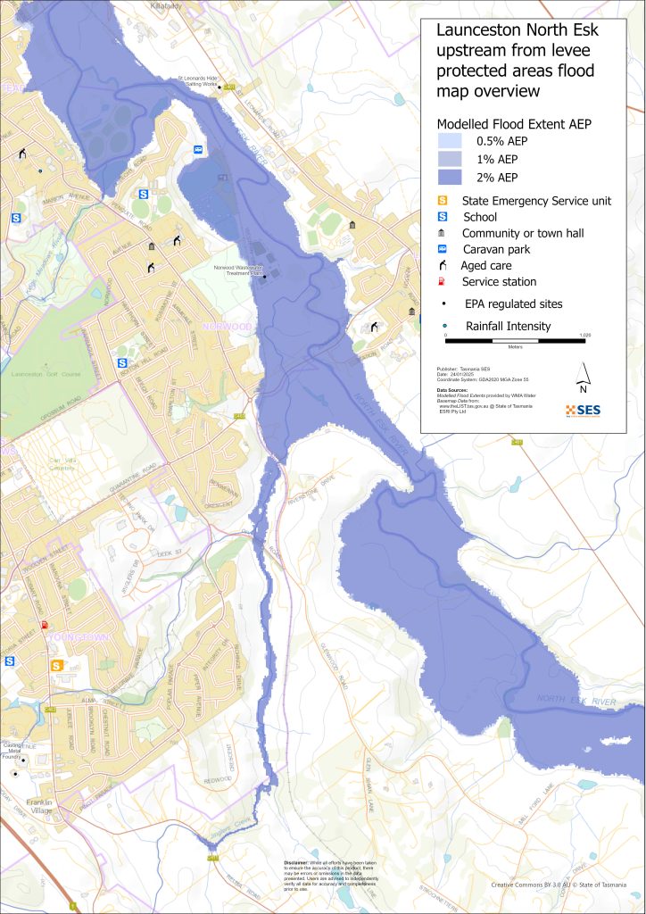
北埃斯克河周边低洼地区
- 科拉林恩、帕特森岛童子军营地和附近的历史鱼塘以及一些住宅
- 圣莱昂纳兹周边
- 车站路
- 霍布勒桥路
- 韦弗利路
- 拉文斯伍德路
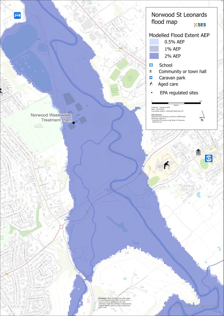
- 诺伍德和纽斯特德地区,不包括防洪堤保护区,包括桑当路(老麦农场)上的房车公园
- 韦弗利 – 布默路
南埃斯克河和塔玛尔河低洼周边地区
- 卡塔拉科特峡谷保护区 - 第一盆地
- 海港区
- 国王码头区
- 西塔马尔高速公路区域
其他低洼地区易发山洪/地表径流
山洪是指暴雨过后很快发生的洪水。除了笼统的恶劣天气警报外,往往几乎没有预警。朗塞斯顿周边有许多小型水道,可能会迅速被淹没。由于山洪或地表径流可能被淹没的低洼地区包括
- 京格斯溪附近的雷尔比亚
- 国王草甸/ 拳击场
- 纽纳姆(Newnham)——因纽纳姆溪(Newnham Creek)和巴纳德溪(Barnards Creek)的洪水涌入
- 南朗塞斯顿
- 韦弗利
- 法拉第街,位于酿酒溪附近
- 从酿酒 creek/北埃斯克河到 Ravenswood Road。.
如果雨水非常充沛,可能会产生雨水径流,影响任何区域的建筑物和道路。.
朗塞斯顿周边地区
有关周边地区洪水的更多信息,请参阅附近的以下相关指南:
您有洪水风险吗?
朗塞斯顿地区有悠久的洪水历史。自欧洲人定居以来
- 1852年,1863年和1893年,朗塞斯顿都曾发生过严重的洪水事件记录。.
- 1929年是现代历史上记录到的最严重的一次洪水。一千多户房屋和建筑物遭到破坏,有些被冲毁。峡谷区的两座悬索桥遭到损坏。四千人从因弗梅、因弗雷斯克和玛格丽特街地区被疏散。直到1940年,朗塞斯顿才从洪水的影响中恢复过来。1929年的洪水为修建堤坝提供了动力。.
- 2016年——朗塞斯顿为应对重大洪水事件做好了准备,并关闭了部分堤坝。.$2.16亿英镑——如果之前的旧堤坝失效,那么此前对堤坝系统的升级工程将避免损失约.
- 2022年 – 朗塞斯顿险些遭遇重大洪水事件。.
气象局(BoM)预报、警告和观测
英联邦发出 洪水观察 当预测天气可能导致该地区发生洪水时,洪水观察可能:
- 特定区域,例如 南埃斯克河 集水区,例如,或者
- 概括为,例如,适用于 中部北方河流流域
物料清单问题 洪水警告 南埃斯克河和北埃斯克河的具体洪水水位。河上的洪水水位计会发出警报
- 洪水水位,以及
- 朗塞斯顿可能产生的影响。.
涨潮也会加剧洪水。.
当北埃斯克河或南埃斯克河可能达到一定水位时,该局将发布轻度、中度或重度洪水警报。下表还显示了州应急服务局因这些河流洪水发出疏散警报的触发水位。.
| 河道水位站 | 未成年 | 适度 | 特大洪水 | 疏散关键决策点 |
| 北埃斯克河 @ 克拉林 |
2.7 毫安时 80 立方米/秒 |
3.6毫安时 200立方米/秒 |
4.9毫安时 419 立方米/秒 约 20% AEP |
6.1 毫安时 800 立方米/秒 关于 2% AEP 新斯泰德堤防保护区 (LPA) |
| 南埃斯克河@特里瓦林池塘 |
128.2 毫安时 约 420 立方米/秒 > 20% AEP |
129.9 毫安时 大约. 1500 立方米/秒 Approx. 10%AEP |
130.9 米A高清 大约. 2000立方米/秒 约 5% AEP |
2250 立方米/秒 2%-1% AEP之间 因弗梅伊/因弗雷斯克堤防保护区 |
|
2500 立方米/秒 – 介于 <1% AEP 之间 市 / 东朗塞斯顿堤防保护区 |
||||
|
3500 立方米/秒 – 位于 >1% AEP 之间 玛格丽特街堤防保护区 |
笔记:
- 立方米/秒 (cumec) – 每秒钟有一立方米的水流过某一点。一立方米的水等于一千升,重一吨。.
- Annual Exceedance Probability (%AEP) is the likelihood of such an event happening any given year, based on historical records up to 2016. With climate change, this likelihood is changing. Updates of this data is underway.
- mAHD – 海拔基准面以上米数。这是水位测量站的本地高度。.
我应该怎么做?
-
- 查看地图,了解您的住宅或商家是否可能发生洪水。.
-
- 评估您的住宅或企业,并做好准备以最大程度地减少潜在的洪水损害。.
-
- 洪水期间,检查您是否能够安全地到达家、工作地点或学校。.
-
- 准备家庭应急计划。考虑是否需要在洪水来临前撤离。参见 做好应急准备– 个人和家庭应急准备指南。.
-
- 如果你是初级生产者, 农场防洪应急包 为洪水提供准备建议,以帮助保护您的企业和库存。.
-
- If you run a business or other organisation, check out the Tasmanian Government’s Emergency Ready Business tool online
-
- 如果您可能被隔离并且必须获得服务,您可能需要提早撤离。.
-
- 如果您在易发洪灾的地区露营,请务必随时了解情况,如果可能发生洪水,请及早转移到高地。.
像地图上显示的洪水,或者更糟糕的情况,将会再次发生。没有两次洪水是相同的。.
如果您住在低洼地区或靠近水道,您的房屋可能会被淹没。即使您的家是安全的,您也可能需要绕过洪水地区,或者您的道路通行可能会受到阻碍。切勿驾车进入或进入洪水区域。道路和桥梁可能被冲毁或不安全。请避免在洪水期间出行。.
了解该怎么做可以拯救你的生命并帮助保护你的财产。制定家庭应急计划是准备工作的最佳方法之一。决定天气和降雨触发条件,以便知道何时采取行动。.
气象局(BoM)预报、警告和观测
英联邦发出 洪水观察 当预测天气可能导致该地区发生洪水时,洪水观察可能:
- 特定区域,例如 南埃斯克河 集水区,例如,或者
- 概括为,例如,适用于 中部北方河流流域
物料清单问题 洪水警告 with specific flood heights for the South Esk and North Esk Rivers. Flood gauges along the rivers give warnings of
- 洪水水位,以及
- 朗塞斯顿可能产生的影响。.
涨潮也会加剧洪水。.
The Bureau will issue Minor, Moderate or Major flood warnings when the North Esk or South Esk Rivers are likely to reach certain heights. The table below also shows the trigger levels for SES to issue evacuation warnings due to flooding from these rivers.
| 河道水位站 | 未成年 | 适度 | 特大洪水 | 疏散关键决策点 |
| 北埃斯克河 @ 克拉林 | 2.7 毫安时
80 立方米/秒 |
3.6毫安时
200立方米/秒 |
4.9毫安时
419 立方米/秒 约 20% AEP |
6.1 毫安时
800 立方米/秒 关于 2% AEP 新斯泰德堤防保护区 (LPA) |
| 南埃斯克河@特里瓦林池塘 | 128.2 毫安时 约 420 立方米/秒
> 20% AEP |
129.9 毫安时 大约.
1500 立方米/秒 Approx. 10%AEP |
130.9 米A高清 大约.
2000立方米/秒 约 5% AEP |
2250 立方米/秒
2%-1% AEP之间 因弗梅伊/因弗雷斯克堤防保护区 |
| 2500 立方米/秒 – 介于 <1% AEP 之间
市 / 东朗塞斯顿堤防保护区 |
||||
| 3500 立方米/秒 – 位于 >1% AEP 之间
玛格丽特街堤防保护区 |
笔记:
- 立方米/秒 (cumec) – 每秒钟有一立方米的水流过某一点。一立方米的水等于一千升,重一吨。.
- Annual Exceedance Probability (%AEP) is the likelihood of such an event happening any given year, based on historical records up to 2016. With climate change, this likelihood is changing. Updates of this data is underway.
- mAHD – 海拔基准面以上米数。这是水位测量站的本地高度。.
理解警告和关键信息
留意周围发生的事情。定期查看预报、观测和警报。.
 |
建议 (黄色): 事件已发生。无即时危险。请保持关注,以防情况发生变化。. |
 |
观察并行动(橙色): 威胁级别有所提高。情况正在变化,您需要立即开始采取行动来保护您和您的家人 |
 |
紧急警报(红色): 紧急警报是最高级别的警报。您可能面临危险,需要立即采取行动。任何耽搁都可能危及您的生命。. |
 |
社区更新(蓝色): 关于特定事件或事件,受影响社区的具体信息和最新动态。. |
| 事件(白色): 事件是指在成为紧急警报之前的初次发生。一旦报告了事件,TasALERT 就会发布基本信息,包括事件的类型和地点。. |
洪水水位
虽然没有两次洪水是相同的,但以下描述了该地区不同洪水级别的情况。即使您的财产没有被淹没,您也需要考虑通行问题。不同强度的降雨,持续时间和地面事先的湿润程度以及降雨地点都会导致洪水。.
北埃斯克河/南埃斯克河和塔马尔河的轻微河岸洪水
北埃斯克河在科拉林有至少2.7米
- 农业用地/河畔公园,例如圣莱昂纳德野餐区
- 可能封路:亨利街
- 河边的低洼房产:
- 车站路
- 亨利街
- 基拉法迪街
- 沙当路老麦农场房车公园
- 西部铁路线和站场
- 苏格兰橡树公园和奎奇公园
- 南埃斯克河特里瓦林池塘至少 128.2 米
- 农田/河畔公园,例如:瀑布峡谷保护区和峡谷游泳池,角点游行场地周围
- 国王码头
- 海港家园 閲兵低洼地区
- 西塔马尔赛艇俱乐部
- 亨利街地区
- 塔玛尔西部高速公路南向车道可能受到洪水影响,交通将改道。.
北埃斯克河/南埃斯克河和塔马尔河的洪水泛滥
- 许多堤坝的闸门将关闭,限制了市区内的交通。跨河的主要道路包括:
- 西塔玛罗路
- 亨利街
北埃斯克河在科拉林至少3.6米
根据轻度洪水,外加
- Station Road 道路以及临近河流的低洼地带的房产
- 亨利街周边区域及低洼地区
- 斯克奇奥克本学院椭圆形/车间
- 霍布勒斯桥路和无板篮球中心
- 基拉法迪路地势较低的房产
- 格伦伍德路地势较低的房产
- 比尔格罗夫车道,莫布雷。.
- 南埃斯克河在特里瓦林池塘,至少 129.9 米
- 根据轻微洪水加上
- 西塔玛路双向车辆改道至侧街
- 海港大道
- 亨利街和下诺斯克河其他地区将受到一些影响
- 特里瓦林池塘流量为 1600 立方米/秒——因弗梅伊部分地区自愿疏散(见因弗梅伊洪水指南)
- 比尔格罗夫车道,莫布雷。.
北埃斯克河/南埃斯克河和塔马尔河发生严重河流洪水
科拉林(Corra Linn)处的北埃斯克河(North Esk)水位至少达4.9米(约20% AEP)
根据中度洪水,外加:
- 哈特街防洪堤已关闭,因弗梅伊部分防洪堤已关闭
- 货场水闸已关闭
- 布莱辛顿路南埃斯克河桥
- 车站路进一步的房产
- 拉尔梅尼耶学校靠近河边的校区
- 各种污水泵站可能会受到影响
- 约翰逊路/车站路
- 800 m3/s @ Corra Linn- Newstead – Hart St area mandatory evacuation (Approx 2%AEP)
- 南埃斯克河特雷瓦林池,至少130米(2000立方米/秒)
- 根据中度洪水加
- 2250立方米/秒 – 因弗梅强制疏散 – 参见因弗梅洪水指南
- 2500立方米/秒 – 因弗梅运河堤坝可能决堤。市中心地区强制撤离 – 请参阅朗塞斯顿和东朗塞斯顿/朗塞斯顿 – 玛格丽特街地区洪水指南。,
- 海港区和国王码头部分地区发生洪水
- Other areas – flash flooding from minor waterways (1-2%AEP)
- 小型水道的突发洪水可能发生得很快,而且预警信息很少。风险区域包括
- 雷尔比亚路桥梁以及沿河的一些低洼房产
- 雷尔比亚路
- 红杉月桂
- 负鼠路
- 格伦伍德路.
- 国王草甸,靠近国王草甸小溪,包括霍巴特路
- 南朗塞斯顿低洼地区,包括玛格丽特街/巴瑟斯特街附近,以及米德兰高速公路惠灵顿街交叉口附近,以及附近低洼房产
- Newstead 地势低洼的道路和房产,尤其是在 Robin Street 附近
- 东朗塞斯顿道屿和道灵街附近的地产。.
- 纽纳姆、莉莉代尔路(Lilydale Road)和贝尔湾(Bell Bay)铁路在巴纳德斯溪(Barnards Creek)道口,以及几处地产。.
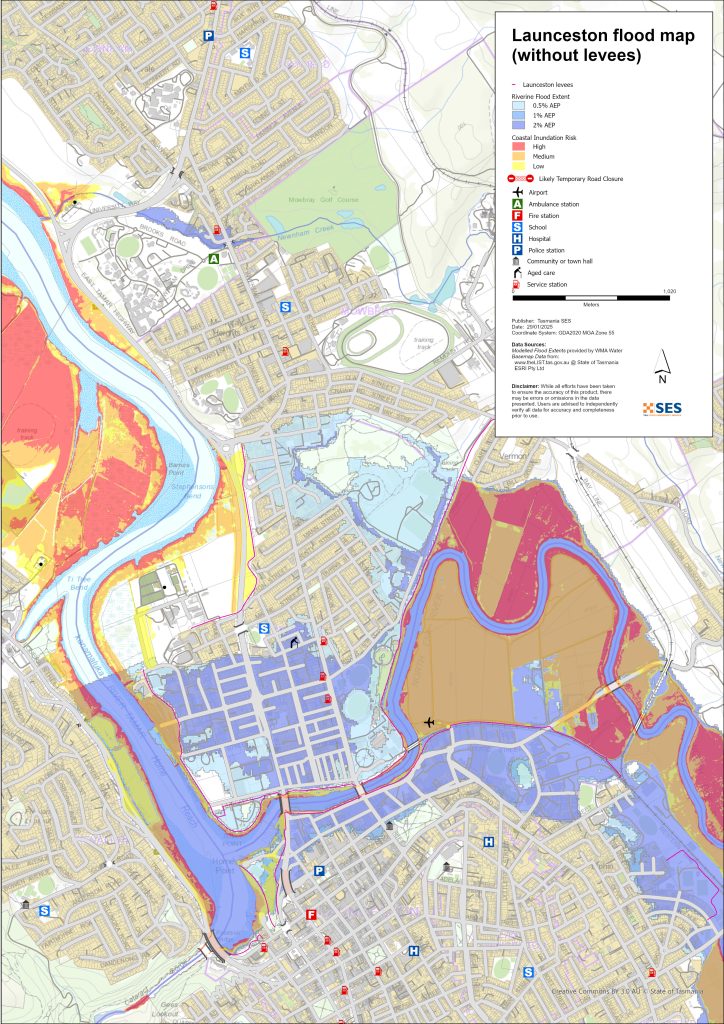
本指南中的地图显示了每年发生概率为1%的洪水水位,既包括部分区域受到堤坝保护的情况,也包括堤坝决口或被洪水漫顶的情况。这些地图未显示地表径流/雨水径流。 除非遭遇伴随特大降雨的严重风暴,否则朗塞斯顿的主要洪水风险主要来自市内主要河流。.
朗塞斯顿市两条主要河流系统可能同时发生洪水,并且在同一次事件中可能出现不同程度的洪水。塔马尔河(kanamaluka/River Tamar)是潮汐河,也可能影响洪水高度。.
您一生中很可能会经历地图所示的洪水。塔斯马尼亚人需要为不经常发生的洪水事件以及他们可能经历过的轻微洪水做好准备。.
在一场重大洪灾中,如果堤坝闸门关闭,道路被淹没,拉恩塞斯顿市可能会被从中间隔开,直到水位退去:
- 中央商务区和市中心南部地区
- 北岸和东北岸的北埃斯克河/塔马尔河地区
- 塔玛尔河以西和西北部的特里瓦林/河畔地区
根据周边地区的降雨情况,可能还有其他路线。但是,交通可能会非常拥挤。.
即使您的房屋没有被淹没,您也应该为做好准备
- 城市的主要交通路线将被切断,
- 潜在的电力和电信中断。.
如果部分地区有防洪堤保护区强制疏散令,电力、水和燃气将被关闭
- 减少危险,并且
- 保护资产,以便在事件发生后尽快恢复。.
该地区旅行可能会很困难,甚至不可能,直到
- 道路畅通,而且
- 洪水闸门已重新开启。.
如果你在家中或其他地方是安全的,除非发生紧急情况,否则通常最好待在原地,直到洪水退去。如果需要撤离,你应该提早离开,在洪水上涨之前。.
Go to TasALERT.com or listen to ABC local radio for detailed up to date information and advice during heavy rainfall events.
了解风险,做好准备,尽可能降低风险,与他人联系,保持警惕,并安全行事。.
洪水之前
做好应急准备 – 个人和家庭应急准备指南。.
了解您的风险
塔斯马尼亚州经常发生洪水,可能造成广泛而重大的损失。在过去的 200 年里,塔斯马尼亚州有 78 人死于与洪水有关的事故。本指南旨在帮助您了解您所在地区的洪水风险。.
2. 准备您的家庭
制定涵盖风暴和洪水的应急计划
考虑一下在风暴或洪水来临时你会怎么做,这意味着你会有更好的准备,每个人都会更安全。制定一个你的家庭成员都明白的应急计划。有一些清单可以帮助你完善你的计划——请看 做好应急准备 – 个人和家庭应急准备指南。.
定期检查您的计划,并让家中的每一位成员都模拟可能影响您家庭的洪水场景进行演练。.
准备一个应急包
准备好了
-
- 电池供电的收音机和手电筒,备用电池
-
- 重要信息,例如您的应急计划
-
- 紧急电话号码列表
-
- 食物和水
-
- 急救箱
-
- 橡胶或结实的皮革手套
视情况打包
-
- 保暖衣物、结实的鞋子或靴子
-
- 药品、眼镜或其他必需品
-
- 手机和充电器
-
- 宠物食品以及它们所需的其他任何物品
-
- 照片和特别的纪念品
-
- 钱
-
- 重要文件,例如
-
- 保险单据
-
- 护照和
-
- 出生证明
-
- 重要文件,例如
定期测试收音机和手电筒里的电池。.
3. 尽可能降低洪水风险
-
- 在购买、维护或开发房产时,请考虑风暴、洪水和其他危险。.
-
- 修剪或移除您家中、商铺上方或您物业附近电线上方的树木和树枝。.
-
- 保持雨水槽和排水沟畅通。.
4. 与他人联系
Know your neighbours and get involved in your community. A connected community is a safer and more resilient community in an emergency and can help everyone recover better afterwards. Check that family and neighbours are safe and aware of what’s happening.
于
5. 保持更新
留意周围发生的事情。定期查看预报、观测和警报。.
-
- 这 气象局 网站.
6. 确保安全
-
- 看管好孩子。.
-
- 为应对可能的电力、供水或网络中断做好准备。.
-
- 检查您的应急包是否已准备好。.
-
- 避开积水区域,如排水沟。. 永不 在洪水期间徒步、玩耍、骑车或驾车。您无法分辨水下有什么,也无法判断水深或水流速度。在仅 20 厘米的快速流动的水中,很容易被冲走并溺水。洪水可能很危险。.
当地面发生洪水时
-
- 将家用物品放在高处以最大程度地减少可能的损坏。.
-
- 如果安全的话,请关闭水电煤气。.
-
- 一种防止污水倒灌回家的好方法是将沙袋放入塑料袋中,然后用它们堵住马桶、覆盖排水管和水槽。.
-
- 趁还能安全离开就走。.
如果您需要撤离
-
- 遵循 SES / 塔斯马尼亚警方 的建议。.
-
- 带上你的应急包。.
-
- 去安全地点或避难中心与亲友会合。.
-
- 让别人知道你去了哪里。.
照顾好您的动物
You are responsible for your animals in an emergency. If you have pets and other animals it will take you longer to evacuate in a flood or other emergency. Move livestock from flood prone areas well before flood waters may rise. For more information see
避免在风暴期间和风暴过后出行
-
- 不要去观光。游客会延误紧急服务并造成事故。.
-
- 注意诸如
-
- 路面积水
-
- 受损的电力线
-
- 山体滑坡
-
- 损坏的道路
-
- 倒下的树木或屋面板。.
-
- 注意诸如
-
- 切勿冒险涉水。洪水中的大多数死亡和救援事件都与驾车涉水有关。.
-
- 在未受洪水影响的路段,请慢行并打开车头灯。.
之后
-
- 请继续收听 ABC 本地广播电台的最新消息、道路重新开放信息、社区会议等。.
-
- 如果您离开了家,在紧急事务管理署(SES)或塔斯马尼亚警方告知您可以安全返回之前,请勿回家。.
-
- 注意道路危险,例如路面上的泥土或碎屑、损坏的道路/桥梁以及正在进行清理和维修的工作人员。.
如果您的房屋遭到损坏
-
- 在检查损坏时,请留在地面。注意倒下的树木、碎玻璃、松动的屋顶或其他危险。.
-
- 穿结实的靴子、手套和防护服。.
-
- 在受洪水影响的建筑物内部,请使用手电筒,切勿使用火柴或蜡烛。.
-
- 饮用水必须煮沸,直到被告知自来水安全为止。.
-
- Do not turn on it is tested by a licensed electrician or gas fitter for safety.
-
- 如果您的房屋受损,需要住到别处,请带上您的应急包和宠物。
-
- 如果安全,请拍摄任何损坏的照片并联系您的保险公司。.
-
- 看管好孩子。.
-
- 检查邻居是否安好。.
欲了解更多信息,请访问 www.ses.tas.gov.au
保持知情和获取更多信息
Current warnings – TasALERT.com
Emergency Broadcasters – 您当地的ABC广播电台
TASSES Social Media – facebook.com/sestasmania
防洪应急准备 ses.tas.gov.au/flood-plan/
全国接力服务 (NRS) relayservice.gov.au
Local Emergency Broadcasters ABC 91.7FM
朗赛斯顿市 Launceston.tas.gov.au 6323 3000
免责声明
The maps show potential flooding risks from consistent levels of rainfall across catchments, such as a 1% Annual Exceedance Probability (AEP). In flooding events, rainfall is likely to be more inconsistent across a catchment, so these flood maps should be considered indicative only. The mapped areas of flood risk show higher probability of inundation. Other areas have lower probability of flooding, but in severe and rare events (rarer than 1%AEP), other lower areas may be also at risk of inundation.
本指南中的信息在出版日期时是准确的。尽管已尽一切努力确保所提供数据的有效性和准确性,但州应急服务部门不对数据错误或疏漏负责。请参阅标准 塔斯马尼亚州政府版权与免责声明 更多详情.
