
론서스턴 비제방 보호 지역 홍수 안내
Riverine flooding and flash flooding information for communities and properties in Launceston outside the levee protected areas
For levee protected areas, see the related flood guides for
Version 1.1 April 2026 – see the PDF version
This flood guide is for people in the areas of Launceston not protected by levees. Even if your home is not flooded, everyone around Launceston would be impacted by a major flood in the city. This guide also covers minor and moderate flooding, plus flash flooding in all areas of the city.
Parts of Launceston can flood from the
- kanamaluka / River Tamar Estuary
- North Esk River
- South Esk River.
There are also some minor waterways that can flood properties and roadways.
Launceston levee protected areas
Launceston’s levees reduce flood risk for many areas along the major rivers. However, there is no guarantee the levees will withstand a major flood. Experiences in other countries show that levees can fail, both gradually and suddenly. If the levees fail, low lying parts of the city may flood quickly. In major floods, people in the levee protected areas should evacuate in case
- the levees fail, or
- flood waters overtop the levees.
Please see the related flood guides for the levee protected areas of
These guides for the levee protected areas have important information about
- triggers for evacuation in major flood events
- how to evacuate, including evacuation routes to use.
If the North and/or South Esk Rivers may reach certain heights, these areas will have:
- A voluntary evacuation warning – where people are advised to leave for their safety
- A mandatory evacuation warning – where people should leave those areas for their safety, and so gas, electricity and water can be cut for those areas.
- In major flood events, people outside flood prone areas need to be aware that
- Major traffic routes through the city may be cut
- Traffic is likely to be very heavy
- There may be cuts to some essential services, such as water treatment.
- There may be cuts to some other services as major transport routes are cut.
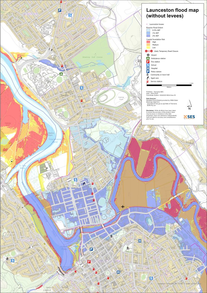
Areas that can flood outside the levee protected areas
Rivers can flood some areas outside the levee protected areas. High tides can also increase water levels in areas closer to the River Tamar.
For more detailed flood maps, see www.launceston.tas.gov.au/Emergency-Management-Hub/1.-Understand-your-risk/Flood to
- Check the Launceston Flood Maps to assess your level of riverine flood risk.
- Check the Urban (Stormwater) Flooding Map for flash flooding storm water flood maps.
- Find out more about Launceston’s flood levees.
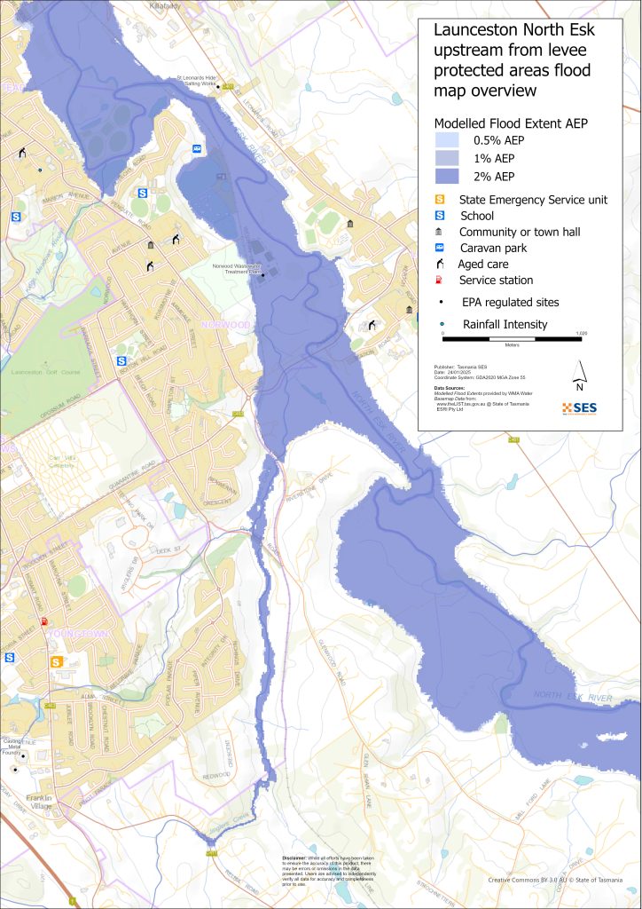
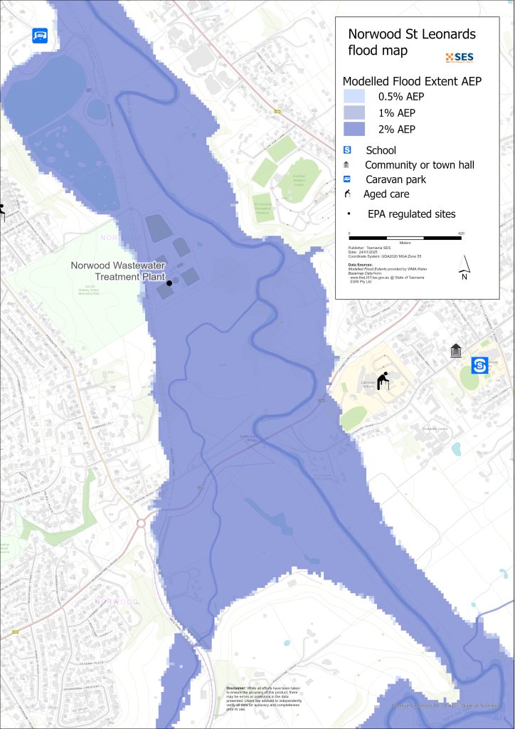
North Esk River surrounding low-lying areas
- Corra Linn, Patersons Island scout camp and nearby historic fishponds plus some homes
- St Leonards around
- 정거장 길
- Hoblers Bridge Road
- Waverley Road
- Ravenswood Road
- Norwood and Newstead areas outside the levee protected area, including the caravan park on Sandown Road (Old Mac’s Farm)
- Waverley – Boomer Road
South Esk and River Tamar low-lying surrounding areas
- Cataract Gorge Reserve – First Basin
- Seaport Precinct
- Kings Wharf area
- West Tamar Highway area
Other low-lying areas exposed to flash flooding/ overland flow
Flash flooding is flooding that happens very soon after heavy rain falls. There can often be little warning aside from a general severe weather warning. There are many minor waterways around Launceston that can flood quickly. Low-lying areas that can flood due to flash flooding or overland flow include parts of
- Relbia near Jinglers Creek
- Kingsmeadows/ Punchbowl
- Newnham – from flash flooding from Newnham Creek and Barnards Creek
- South Launceston
- Waverley
- Faraday Street from Distillery Creek
- Ravenswood Road from Distillery Creek/ North Esk River.
If there is very intense rain, there can be storm water run-off that can affect buildings and roads in any area.
Areas surrounding Launceston
For information about flooding in surrounding areas, see nearby related guides for:
- Lilydale and surrounds
- Nunamara and surrounds – currently under development
- Hadspen/ Blackstone Heights
홍수 위험이 있습니까?
The Launceston area has a long history of flooding. Since European settlement
- 1852, 1863 and 1893 had serious flood events recorded for Launceston.
- 1929 was the most severe flooding recorded in modern history. Over a thousand homes and buildings were damaged, with some swept from their foundations. The two suspension bridges over the Gorge area were damaged. Four thousand people were evacuated from Invermay, Inveresk and Margaret Street areas. It was not until 1940 that Launceston recovered from the flood. The 1929 floods provided incentive to build the levees.
- 2016 – Launceston prepared for a major flood event and closed some levees. Previous upgrades of the levee system helped avoid losses of about $216 million, had the previous ageing levees failed.
- 2022 – Launceston narrowly escaped a major flooding event.
기상청(BoM) 예보, 경고 및 관측
The BoM issues a 홍수 주의보 when predicted weather might cause floods in the area. A Flood Watch may:
- be for a specific area such as the South Esk River catchment, for example, or
- be generalised such as for 중앙 북부 수계
The BoM issue Flood Warnings with specific flood heights for the South Esk and North Esk Rivers. Flood gauges along the rivers give warnings of
- flood heights, and
- the possible impacts in Launceston.
High tides can also add to flooding.
The Bureau will issue Minor, Moderate or Major flood warnings when the North Esk or South Esk Rivers are likely to reach certain heights. The table below also shows the trigger levels for SES to issue evacuation warnings due to flooding from these rivers.
| River gauge sites | 마이너 | 적당한 | Major flood | Evacuation Critical Decision Points |
| North Esk River @ Corra Linn |
2.7 mAHD 80 m³/s |
3.6 mAHD 200 m³/s |
4.9 mAHD 419 m³/s Approx. 20% AEP |
6.1 mAHD 800 m³/s About 2% AEP Newstead Levee Protected Area (LPA) |
| South Esk River @ Trevallyn Pond |
128.2 mAHD approx. 420 m³/s > 20% AEP |
129.9 mAHD approx. 1500 m³/s Approx. 10%AEP |
130.9 mAHD approx. 2,000 m³/s Approx. 5% AEP |
2250 m³/s Between 2%-1% AEP Invermay /Inveresk Levee Protected Area |
|
2500 m³/s – Between <1% AEP City /East Launceston Levee Protected Area |
||||
|
3500 m³/s – Between >1% AEP Margaret Street Levee Protected Area |
Notes:
- m³/s (cumec) – one cubic meter of water flowing past a point in one second. One cubic meter of water equals one thousand litres and weighs one tonne.
- Annual Exceedance Probability (%AEP) is the likelihood of such an event happening any given year, based on historical records up to 2016. With climate change, this likelihood is changing. Updates of this data is underway.
- mAHD – Metres above height datum. This is a local height for the gauging site.
무엇을 해야 할까요?
-
- 집이나 사업장이 침수될 수 있는지 지도를 확인해 보세요.
-
- 가정이나 사업장을 평가하고 가능한 홍수 피해를 최소화하도록 준비하세요.
-
- 홍수 시 집, 직장 또는 학교에 안전하게 갈 수 있는지 확인하세요.
-
- 집 비상 계획을 준비하세요. 홍수가 발생하기 전에 대피해야 하는지 고려해 보세요. 비상 사태에 대비하세요– 개인 및 가구 비상 대비 안내서.
-
- 당신이 1차 생산자라면, 농장 홍수 대비 키트 사업체와 재고를 보호하는 데 도움이 되는 홍수 대비 요령을 제공합니다.
-
- If you run a business or other organisation, check out the Tasmanian Government’s Emergency Ready Business tool online
-
- 고립될 수 있고 서비스를 이용해야 한다면 조기에 대피해야 할 수도 있습니다.
-
- 홍수에 취약한 지역에서 캠핑하는 경우, 관련된 정보를 계속 파악하고 홍수가 우려되면 일찍 높은 곳으로 대피하도록 하십시오.
지도에 표시된 것과 같은 홍수, 혹은 그보다 더 심각한 홍수가 다시 발생할 것입니다. 두 번의 홍수가 똑같은 경우는 없습니다.
저지대나 하천 근처에 거주하는 경우, 집이 침수될 수 있습니다. 집이 안전하더라도 침수된 지역을 우회해야 하거나 도로가 차단될 수 있습니다. 절대로 침수된 물 속으로 차를 몰거나 들어가지 마십시오. 도로와 다리가 유실되었거나 위험할 수 있습니다. 홍수 발생 시에는 외출을 삼가십시오.
무엇을 해야 할지 아는 것은 생명을 구하고 재산을 보호하는 데 도움이 될 수 있습니다. 가정 비상 계획을 세우는 것은 대비하는 가장 좋은 방법 중 하나입니다. 행동할 시점을 결정하기 위한 날씨와 강우량 트리거를 결정하십시오.
기상청(BoM) 예보, 경고 및 관측
The BoM issues a 홍수 주의보 when predicted weather might cause floods in the area. A Flood Watch may:
- be for a specific area such as the South Esk River catchment, for example, or
- be generalised such as for 중앙 북부 수계
The BoM issue Flood Warnings with specific flood heights for the South Esk and North Esk Rivers. Flood gauges along the rivers give warnings of
- flood heights, and
- the possible impacts in Launceston.
High tides can also add to flooding.
The Bureau will issue Minor, Moderate or Major flood warnings when the North Esk or South Esk Rivers are likely to reach certain heights. The table below also shows the trigger levels for SES to issue evacuation warnings due to flooding from these rivers.
| River gauge sites | 마이너 | 적당한 | Major flood | Evacuation Critical Decision Points |
| North Esk River @ Corra Linn | 2.7 mAHD
80 m³/s |
3.6 mAHD
200 m³/s |
4.9 mAHD
419 m³/s Approx. 20% AEP |
6.1 mAHD
800 m³/s About 2% AEP Newstead Levee Protected Area (LPA) |
| South Esk River @ Trevallyn Pond | 128.2 mAHD approx. 420 m³/s
> 20% AEP |
129.9 mAHD approx.
1500 m³/s Approx. 10%AEP |
130.9 mAHD approx.
2,000 m³/s Approx. 5% AEP |
2250 m³/s
Between 2%-1% AEP Invermay /Inveresk Levee Protected Area |
| 2500 m³/s – Between <1% AEP
City /East Launceston Levee Protected Area |
||||
| 3500 m³/s – Between >1% AEP
Margaret Street Levee Protected Area |
Notes:
- m³/s (cumec) – one cubic meter of water flowing past a point in one second. One cubic meter of water equals one thousand litres and weighs one tonne.
- Annual Exceedance Probability (%AEP) is the likelihood of such an event happening any given year, based on historical records up to 2016. With climate change, this likelihood is changing. Updates of this data is underway.
- mAHD – Metres above height datum. This is a local height for the gauging site.
경고와 중요 정보를 이해하십시오
주변 상황에 항상 주의를 기울이십시오. 예보, 관측 및 경고를 정기적으로 확인하십시오.
 |
조언 (노랑): 사건이 시작되었습니다. 즉각적인 위험은 없습니다. 상황이 변할 경우 최신 정보를 계속 확인하십시오. |
 |
시청 및 행동 (주황색) 위협 수준이 높아졌습니다. 상황이 변하고 있으니, 귀하와 가족을 보호하기 위해 지금 바로 행동을 시작해야 합니다. |
 |
긴급 경보 (빨강): 긴급 경보는 최고 수준의 경고입니다. 위험에 처해 즉시 조치를 취해야 할 수 있습니다. 지금 지체하면 생명이 위험해질 수 있습니다. |
 |
커뮤니티 업데이트 (파랑): 특정 사건이나 사고에 대한 영향을 받은 지역사회를 위한 구체적인 정보와 업데이트. |
| 사건 (흰색): 사고는 비상 경보가 발령되기 이전의 최초 발생 사건입니다. 사고가 보고되는 즉시 TasALERT는 사고 유형 및 위치를 포함한 기본 정보를 게시합니다. |
홍수 수위
두 번의 홍수가 똑같지는 않지만, 다음은 지역별 다양한 홍수 수준에 대해 예상할 수 있는 내용입니다. 재산이 침수되지 않더라도 접근성에 대해 생각해야 합니다. 강우 강도, 지속 시간, 사전 지면 상태, 강우량 및 강우 지점에 따라 다양한 수준의 강우량이 홍수를 일으킬 수 있습니다.
Minor Riverine flooding from North Esk/ South Esk and Tamar Rivers
North Esk at Corra Linn at least 2.7m
- Agricultural land/ riverside parklands, for example, St Leonards picnic ground
- Possible road closure – Henry Street
- Low-lying properties near the river on:
- 정거장 길
- Henry Street
- Killafaddy Street
- Old Mac’s Farm Caravan Park on Sandown Road
- Western railway line and yards
- Scotch Oakburn Park and Queechy Park
- South Esk at Trevallyn Pond at least 128.2m
- Agricultural land/ riverside parklands e.g. Cataract Gorge Reserve and Gorge Swimming Pool, Home Point Parade surrounds
- Kings Wharf
- Seaport Home Point Parade low lying areas
- West Tamar rowing club
- Henry Street area
- Flood waters may begin to impact the south-bound lane of the West Tamar Highway, with traffic diverted to alternate routes.
Moderate flooding from North Esk/ South Esk and Tamar Rivers
- Many levee flood gates will close, restricting movement through the city. Major routes to close across the river include:
- West Tamar Road
- Henry Street
North Esk at Corra Linn at least 3.6m
As per minor flooding, plus
- Station Road roadway and further low-lying properties near the river
- Henry Street further areas and low-lying properties
- Scotch Oakburn College oval/ workshop
- Hoblers Bridge Road and Netball Centre
- Low-lying properties on Killafaddy Road
- Low-lying properties on Glenwood Road
- Bill Grove roadway, Mowbray.
- South Esk at Trevallyn Pond at least 129.9m
- As per minor flooding plus
- West Tamar Highway both lanes diverted through side streets
- Seaport Boulevard
- There will be some impacts around Henry Street and other areas on the lower North Esk River
- 1600 m3/s @ Trevallyn Pond – voluntary evacuation parts of Invermay (see Invermay flood guide)
- Bill Grove roadway, Mowbray.
Major riverine flooding from North Esk/ South Esk and Tamar Rivers
North Esk at Corra Linn at least 4.9m (Approx 20% AEP)
As per moderate flooding, plus:
- Hart St flood levee closed, parts of Invermay levee closed
- Railyard flood gates are closed
- Blessington Road South Esk River crossing
- Further properties on Station Road
- Larmenier School grounds near the river
- Various sewage pump stations may be impacted
- Johnson Road/ Station Road
- 800 m3/s @ Corra Linn- Newstead – Hart St area mandatory evacuation (Approx 2%AEP)
- South Esk at Trevallyn Pond at least 130m (2000 m³/s)
- As per moderate flooding plus
- 2250 m³/s – Invermay Mandatory evacuation – see Invermay flood guide
- 2500 m³/s – Invermay levees may overtop. Mandatory evacuation of parts of Launceston city centre – see the flood guides for Launceston and East Launceston/ Launceston – Margaret Street area,
- Parts of Seaport area, Kings Wharf flooded
- Other areas – flash flooding from minor waterways (1-2%AEP)
- Flash flooding from minor waterways can happen quickly, with little specific warning. Areas at risk include
- Relbia Road bridge and some low-lying properties along
- Relbia Road
- Redwood Crescent
- Oppossum Road
- Glenwood Road.
- Kings Meadows near Kings Meadows Rivulet, including Hobart Road
- South Launceston low lying areas near Margaret Street/ Bathurst Street, including Midland Highway near the Wellington Street junction, and nearby low-lying properties
- Newstead low-lying roadways and properties, particularly near Robin Street
- East Launceston roadways and properties around Dowling St.
- Newnham, Lilydale Road and Bell Bay railway line at Barnards Creek crossing, plus several properties.
The maps in this guide show the level of flooding that has a 1% chance of happening any year, both with levee protecting some areas, and if the levees fail or are overtopped. They do not show overland flow/ rainwater run-off. Unless there is a severe storm bringing very heavy rain, the main flooding risks for Launceston are from the city’s major rivers.
Launceston’s two major river systems may flood at the same time and may have different levels of flooding during the same event. The kanamaluka/River Tamar is tidal and may also affect the flooding height.
You are likely to experience flooding such as that shown in the maps in your lifetime. Tasmanians need to prepare for flood events that may not happen often as well as the minor flooding they may have experienced.
In a major flood event, closed levee gates and flooded roads can cut the city of Launceston in three until waters recede:
- The Central Business District and areas to the south of the city centre
- Areas to the North and North East of the North Esk River/ Tamar
- Trevallyn/ Riverside area to the West and North West of the Tamar River
Depending on rainfall in surrounding areas, there may be alternative routes. However, traffic is likely to be very heavy.
Even if your home is not inundated, you should be prepared for
- major traffic routes through the city to be cut, and
- 잠재적인 전력 및 통신 장애.
If some areas there is a mandatory evacuation order for levee protected areas, electricity, water and gas will be switched off to
- reduce hazards, and
- protect assets so they can be restored as soon as possible after the event.
Travel in the area is likely to be difficult or impossible until
- roads are clear, and
- flood gates are reopened.
If you are safe at home or elsewhere, it is usually best you stay where you are until the flooding subsides, unless there is an emergency. If you need to evacuate, you should leave early, before flood waters rise.
Go to TasALERT.com or listen to ABC local radio for detailed up to date information and advice during heavy rainfall events.
위험을 인지하고, 대비하며, 가능한 위험을 줄이고, 다른 사람들과 연결하고, 경계를 늦추지 말고 안전하게 행동하십시오.
홍수 전에
비상 사태에 대비하세요 – 개인 및 가구 비상 대비 안내서.
1. 당신의 위험을 알아라
태즈메이니아에서는 홍수가 자주 발생하며 광범위하고 심각한 피해를 야기할 수 있습니다. 지난 200년 동안 태즈메이니아에서는 홍수와 관련된 사망자가 78명 발생했습니다. 이 가이드는 귀하의 지역에서의 홍수 위험을 이해하는 데 도움을 드리기 위한 것입니다.
2. 집안일 준비
폭풍우와 홍수에 대비한 비상 계획을 세우십시오.
폭풍이나 홍수 상황에서 무엇을 할지 생각해 보는 것은 더 잘 준비되어 있고 모두의 안전을 보장하는 데 도움이 됩니다. 가족 모두가 이해하는 비상 계획을 세우세요. 계획 수립에 도움이 되는 체크리스트가 있습니다. 비상 사태에 대비하세요 – 개인 및 가구 비상 대비 안내서.
주기적으로 계획을 확인하고, 가정에 영향을 미칠 수 있는 홍수 시나리오에 대해 온 가족이 함께 생각해 보며 계획을 시험해 보세요.
비상 용품 준비
준비 완료
-
- 배터리식 라디오와 손전등, 여분의 배터리
-
- 비상 계획과 같은 중요 정보
-
- 비상 전화번호 목록
-
- 음식과 물
-
- 구급 상자
-
- 고무 또는 튼튼한 가죽 장갑
필요할 때 짐을 싸세요
-
- 따뜻한 옷, 튼튼한 신발 또는 부츠
-
- 의약품, 안경 또는 기타 필수품
-
- 휴대폰과 충전기
-
- 애완동물 사료와 그 외 필요한 모든 것
-
- 사진과 특별한 기념품
-
- 돈
-
- 중요한 서류, 예를 들어
-
- 보험 서류
-
- 여권 및
-
- 출생증명서
-
- 중요한 서류, 예를 들어
라디오와 손전등의 배터리를 정기적으로 점검하세요.
3. 가능한 경우 홍수 위험을 줄이십시오
-
- 폭풍, 홍수 및 기타 위험 요소를 부동산 구매, 유지 또는 개발 시 고려하십시오.
-
- 집, 사업체 또는 재산 내 전선 근처에 늘어진 나무나 나뭇가지를 정리하거나 제거하십시오.
-
- 배수구와 도랑을 깨끗하게 유지하십시오.
4. 다른 사람들과 연결하기
Know your neighbours and get involved in your community. A connected community is a safer and more resilient community in an emergency and can help everyone recover better afterwards. Check that family and neighbours are safe and aware of what’s happening.
동안
5. 최신 정보를 유지하십시오
주변 상황에 항상 주의를 기울이십시오. 예보, 관측 및 경고를 정기적으로 확인하십시오.
-
- 더 기상청 웹사이트.
6. 안전하게 행동하기
-
- 어린이들을 감독하다.
-
- 정전, 단수, 인터넷 끊김 등 비상 상황에 대비하십시오.
-
- 비상 용품을 준비해 두었는지 확인하세요.
-
- 배수구와 같이 침수된 지역은 피하십시오. 절대 침수된 물에서 걷거나, 놀거나, 타거나 운전하지 마십시오. 물 아래 무엇이 있는지, 물이 얼마나 깊거나 빠르게 흐르는지 항상 알 수는 없습니다. 빠르게 흐르는 물은 20cm만으로도 휩쓸려 익사하기 쉽습니다. 홍수 물은 위험할 수 있습니다.
집이 침수될 수 있을 때
-
- 가구 등을 높은 곳에 올려 피해를 최소화하세요.
-
- 전기 및 가스를 안전하게 차단하십시오.
-
- 하수구가 집안으로 역류하는 것을 막는 좋은 방법은 모래주머니를 비닐봉지 안에 넣고 변기를 막거나 배수구 및 세면대를 덮는 데 사용하는 것입니다.
-
- 안전하게 빠져나갈 수 있을 때 나오세요.
대피해야 하는 경우
-
- SES / 태즈메이니아 경찰의 조언을 따르십시오.
-
- 비상용품을 챙기세요.
-
- 안전한 장소나 대피소에 있는 친구나 가족에게 가세요.
-
- 다른 사람들에게 당신이 어디에 갔는지 알려주세요.
동물을 잘 돌봐주세요
You are responsible for your animals in an emergency. If you have pets and other animals it will take you longer to evacuate in a flood or other emergency. Move livestock from flood prone areas well before flood waters may rise. For more information see
폭풍우가 치는 동안과 폭풍우가 지난 직후에는 여행을 피하십시오.
-
- 관광을 가지 마세요. 관광객은 응급 서비스 제공을 지연시키고 사고를 유발합니다.
-
- 위험에 주의하십시오.
-
- 도로 위 물
-
- 전선 손상
-
- 산사태
-
- 도로 파손
-
- 쓰러지는 나무나 함석.
-
- 위험에 주의하십시오.
-
- 침수된 물을 절대 운전하지 마십시오. 홍수 사망 및 구조의 대부분은 침수된 물을 운전하는 사람들로 인해 발생합니다.
-
- 차량 통행이 가능한 도로는 천천히 운전하고 전조등을 켜세요.
이후
-
- ABC 지역 라디오 업데이트, 도로 재개, 지역 주민 회의 등에 계속 귀 기울여 주세요.
-
- 집을 떠났다면, SES나 태즈메이니아 경찰이 안전하다고 할 때까지 집으로 돌아가지 마십시오.
-
- 도로 위의 흙이나 잔해, 손상된 도로/다리, 청소 및 보수 작업 인원 등 도로 위험 요소를 인지하십시오.
집이 손상되었다면
-
- 지붕이나 지면에서 손상을 확인하세요. 넘어진 나무, 깨진 유리, 부서진 지붕 또는 기타 위험에 주의하세요.
-
- 튼튼한 부츠, 장갑, 보호복을 착용하십시오.
-
- 침수된 건물 내부에서는 성냥이나 촛불을 사용하지 말고, 손전등을 사용하십시오.
-
- 마실 물은 수돗물이 다시 안전하다는 지시가 있을 때까지 모두 끓이세요.
-
- Do not turn on it is tested by a licensed electrician or gas fitter for safety.
-
- 집이 손상되어 다른 곳에 머물러야 한다면, 비상 용품과 반려동물을 챙기세요.
-
- 가능하다면 안전하게 주변의 손상된 부분을 촬영하고 보험 회사에 연락하십시오.
-
- 어린이들을 감독하다.
-
- 이웃들이 괜찮은지 확인해 보세요.
추가 정보는 다음을 참조하십시오 www.ses.tas.gov.au
정보를 얻고 추가 정보를 얻기
Current warnings – TasALERT.com
Emergency Broadcasters – 여러분의 지역 ABC 라디오 방송국
TASSES Social Media – facebook.com/sestasmania
홍수 비상사태 대비 ses.tas.gov.au/flood-plan/
국가 중계 서비스 (NRS) 릴레이서비스.gov.au
Local Emergency Broadcasters ABC 91.7FM
론서스턴 시 Launceston.tas.gov.au 6323 3000
면책 조항
The maps show potential flooding risks from consistent levels of rainfall across catchments, such as a 1% Annual Exceedance Probability (AEP). In flooding events, rainfall is likely to be more inconsistent across a catchment, so these flood maps should be considered indicative only. The mapped areas of flood risk show higher probability of inundation. Other areas have lower probability of flooding, but in severe and rare events (rarer than 1%AEP), other lower areas may be also at risk of inundation.
이 가이드의 정보는 발행일 기준으로 최신 정보를 제공합니다. 제시된 데이터의 유효성과 정확성을 보장하기 위해 모든 노력을 기울였지만, 주 비상 서비스는 데이터 오류 또는 누락에 대해 책임을 지지 않습니다. 표준을 참조하십시오. 태즈메이니아 정부 저작권 및 면책 조항 더 자세한 내용은.
