
레일튼 홍수 가이드
레드워터 계곡과 관련된 홍수 정보
Version 2.1 January 2026 – PDF version
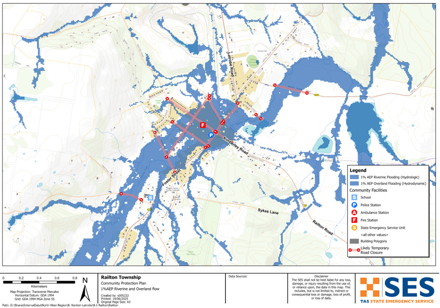
지도를 더 자세히 보려면, 태즈메이니아 전략 홍수 지도 보기.
홍수 위험이 있습니까?
레일턴은 레드워터 크릭의 높은 수량이나 유역의 강렬한 강우로 인해 홍수 위험이 있으며, 두 가지가 동시에 발생할 경우 더 큰 영향을 받을 수 있습니다. 유역의 빠른 반응 때문에 폭우가 내리는 동안 홍수가 빠르게 발생할 수 있으며, 마을에 심각한 영향을 미칠 수 있습니다.
알아야 할 것
- 홍수로 인해 레일턴의 일부 지역이 고립될 수 있습니다. 당분간 탈출하거나 도움을 받기 어려울 수 있습니다.
- 홍수 때문에 마을이 나뉠 수도 있습니다. 대피소나 필수 서비스에 접근하기 어려울 수 있습니다.
- 일단 홍수가 시작되고 도로가 차단되면 비상 물품과 모래주머니를 옮기는 것이 쉽지 않을 수 있습니다.
- 홍수 위험이 있을 경우, 주민들은 모래주머니 설치, 안전한 곳으로 대피 등 조치를 미리 취해야 합니다.
- 갑작스러운 홍수 경고가 발령되지 않을 수 있습니다.
침수는 언제 발생할 수 있나요?
- 갑작스러운 폭우나 지속적인 비로 인해 짧은 시간 안에 갑작스러운 홍수가 발생할 수 있습니다.
- 심한 비가 내린 후 2~6시간 이내에 갑작스러운 홍수가 시작될 수 있습니다.
가장 위험한 사람은 누구인가요?
- 낮은 지대에 거주하거나 Redwater Creek 근처에 사는 사람들.
- 레일턴에 최근 이사 와서 지역 홍수 위험에 익숙하지 않은 주민들.
- 노인 거주자 또는 일상 활동에 도움이 필요한 사람들.
행동할 때
다음 강수량이 기록되었다고 가정하면 셰필드 스쿨 팜 날씨 관측소:
- 30분에 20mm
- 38mm/시간
- 3시간 안에 50mm
레일턴의 과거 침수 이력
레일턴은 1876년, 1894년, 1929년, 1970년, 1973년, 2011년, 2016년을 포함하여 심각한 홍수 이력이 있습니다.
2011년 홍수는 연간 초과 확률(AEP)이 약 1%인 사건과 규모가 비슷했으며, 이는 특정 연도에 발생할 확률이 약 100분의 1임을 의미합니다. 이 홍수로 인해 주택 60채와 상가 14곳이 침수되었으며, 마을 전역의 도로와 거리가 광범위하게 마비되었다.
이전 홍수 때 레일턴 사람들은 자동차 안이나 집 지붕 위에서 홍수에 갇혔던 적이 있습니다. 레일턴의 레드워터 크릭 범람은 머지 강과 대셔 강을 포함한 지역의 다른 수로 범람과 동시에 자주 발생합니다. 이는 레일턴과 셰필드, 라트로브와 같은 다른 마을을 잇는 도로가 침수되고 손상될 수 있음을 의미합니다. 다른 마을의 긴급 구조 서비스가 홍수 시 레일턴에 접근하지 못할 수도 있습니다.
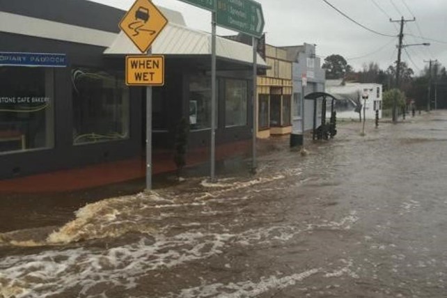
이미지: 2016년 홍수 속의 레일턴 (출처: WMA Water)
무엇을 해야 할까요?
- 집이나 사업장이 침수될 수 있는지 지도를 확인해 보세요.
- 가정이나 사업장을 평가하고 가능한 홍수 피해를 최소화하도록 준비하세요.
- 홍수 시 집, 직장 또는 학교에 안전하게 갈 수 있는지 확인하세요.
- 집 비상 계획을 준비하세요. 홍수가 발생하기 전에 대피해야 하는지 고려해 보세요. 비상 사태에 대비하세요– 개인 및 가구 비상 대비 안내서.
- 당신이 1차 생산자라면, 농장 홍수 대비 키트 사업체와 재고를 보호하는 데 도움이 되는 홍수 대비 요령을 제공합니다.
- If you run a business or other organisation, check out the Tasmanian Government’s Emergency Ready Business tool online
- 고립될 수 있고 서비스를 이용해야 한다면 조기에 대피해야 할 수도 있습니다.
- 홍수에 취약한 지역에서 캠핑하는 경우, 관련된 정보를 계속 파악하고 홍수가 우려되면 일찍 높은 곳으로 대피하도록 하십시오.
지도에 표시된 것과 같은 홍수, 혹은 그보다 더 심각한 홍수가 다시 발생할 것입니다. 두 번의 홍수가 똑같은 경우는 없습니다.
저지대나 하천 근처에 거주하는 경우, 집이 침수될 수 있습니다. 집이 안전하더라도 침수된 지역을 우회해야 하거나 도로가 차단될 수 있습니다. 절대로 침수된 물 속으로 차를 몰거나 들어가지 마십시오. 도로와 다리가 유실되었거나 위험할 수 있습니다. 홍수 발생 시에는 외출을 삼가십시오.
무엇을 해야 할지 아는 것은 생명을 구하고 재산을 보호하는 데 도움이 될 수 있습니다. 가정 비상 계획을 세우는 것은 대비하는 가장 좋은 방법 중 하나입니다. 행동할 시점을 결정하기 위한 날씨와 강우량 트리거를 결정하십시오.
경고와 중요 정보를 이해하십시오
주변 상황에 항상 주의를 기울이십시오. 예보, 관측 및 경고를 정기적으로 확인하십시오.
 |
조언 (노랑): 사건이 시작되었습니다. 즉각적인 위험은 없습니다. 상황이 변할 경우 최신 정보를 계속 확인하십시오. |
 |
시청 및 행동 (주황색) 위협 수준이 높아졌습니다. 상황이 변하고 있으니, 귀하와 가족을 보호하기 위해 지금 바로 행동을 시작해야 합니다. |
 |
긴급 경보 (빨강): 긴급 경보는 최고 수준의 경고입니다. 위험에 처해 즉시 조치를 취해야 할 수 있습니다. 지금 지체하면 생명이 위험해질 수 있습니다. |
 |
커뮤니티 업데이트 (파랑): 특정 사건이나 사고에 대한 영향을 받은 지역사회를 위한 구체적인 정보와 업데이트. |
| 사건 (흰색): 사고는 비상 경보가 발령되기 이전의 최초 발생 사건입니다. 사고가 보고되는 즉시 TasALERT는 사고 유형 및 위치를 포함한 기본 정보를 게시합니다. |
레일턴의 홍수 수위
악천후 경보 및 홍수 주의보는 특정 지역에 예상되는 강우량을 예측할 수 있습니다. BoM 웹사이트의 MetEye 페이지에서 Railton의 상세 강우량 예보를 확인하세요. www.bom.gov.au/tas/forecasts/railton.shtml .
레일턴의 24시간 강우량은 홍수 발생 가능성을 추정하는 데 도움이 될 수 있습니다. 짧은 시간 안에 많은 양의 비가 내리거나 며칠 연속으로 비가 내릴 경우에도 홍수가 발생할 수 있습니다.
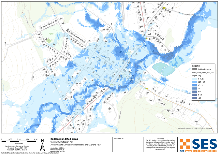
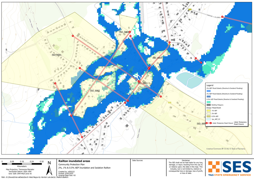
두 홍수가 똑같지는 않지만, 다음과 같이 레일턴 주변의 다른 홍수 수준에서 예상할 수 있는 내용을 설명합니다. 건물에 홍수가 나지 않더라도 접근 경로를 고려해야 합니다.
10% AEP (연도별 10% 발생 확률)
잠재적 강우 유발 요인: 약 6시간 동안 54mm의 비 @ 셰필드 스쿨 팜
어떤 일이 일어날지
-
- 80여 채의 주택과 사업체가 침수될 수 있습니다. 여기에는 크로커스 스트리트, 에스플라네이드, 포스터 스트리트, 깁린 스트리트, 킴벌리 로드, 라트로브 로드, 모리슨 스트리트의 일부가 포함됩니다.
-
- 다우비긴, 포스터, 깁린 모리슨 크로커스, 에스플러네이드, 레일턴, 뉴 베드, 네이티브 플레인스 로드와 같은 지방 도로는 홍수 범람의 영향을 받을 수 있습니다.
-
- 소방서, 주유소, 보육 시설, 텔스트라 교환국 및 일부 상점과 같은 중요 시설이 침수되거나 고립될 수 있습니다.
-
- 도로와 철로가 차단됨에 따라 마을을 드나드는 이동이 영향을 받을 수 있습니다.
-
- 마을의 일부가 서로 단절될 수 있습니다.
2% AEP (연간 발생 확률 2%)
잠재적 강우 유발 요인: 약 6시간 동안 80mm의 비 @ 셰필드 스쿨 팜
10% AEP 플러스에 따르면 어떤 일이 발생할 수 있을까요?
-
- 마을 주변으로 홍수가 더욱 확산되고 있습니다. 약 95채의 주택과 사업장이 침수되거나 고립될 수 있습니다. 여기에는 다운비긴과 칼더 스트리트의 일부 건물도 포함됩니다.
-
- 리크 스트리트와 킹 스트리트 일부 지역이 침수될 수 있습니다.
1% AEP (연간 발생 확률 1%)
잠재적 강우 유발 요인: 약 6시간 동안 86mm의 비 @ 셰필드 스쿨 팜
-
- 2011년과 유사하게 100채 가량의 주택이 침수될 위험이 있는 광범위한 홍수.
-
- 침수되지 않은 일부 주택은 주변 물 때문에 고립될 수 있습니다.
-
- 킹 스트리트 근처의 하수처리장이 침수될 수 있습니다.
-
- 레일턴은 더 오랜 기간 고립될 수 있었습니다.
Go to TasALERT.com or listen to ABC local radio for detailed up to date information and advice during heavy rainfall events.
위험을 인지하고, 대비하며, 가능한 위험을 줄이고, 다른 사람들과 연결하고, 경계를 늦추지 말고 안전하게 행동하십시오.
홍수 전에
비상 사태에 대비하세요 – 개인 및 가구 비상 대비 안내서.
1. 당신의 위험을 알아라
태즈메이니아에서는 홍수가 자주 발생하며 광범위하고 심각한 피해를 야기할 수 있습니다. 지난 200년 동안 태즈메이니아에서는 홍수와 관련된 사망자가 78명 발생했습니다. 이 가이드는 귀하의 지역에서의 홍수 위험을 이해하는 데 도움을 드리기 위한 것입니다.
2. 집안일 준비
폭풍우와 홍수에 대비한 비상 계획을 세우십시오.
폭풍이나 홍수 상황에서 무엇을 할지 생각해 보는 것은 더 잘 준비되어 있고 모두의 안전을 보장하는 데 도움이 됩니다. 가족 모두가 이해하는 비상 계획을 세우세요. 계획 수립에 도움이 되는 체크리스트가 있습니다. 비상 사태에 대비하세요 – 개인 및 가구 비상 대비 안내서.
주기적으로 계획을 확인하고, 가정에 영향을 미칠 수 있는 홍수 시나리오에 대해 온 가족이 함께 생각해 보며 계획을 시험해 보세요.
비상 용품 준비
준비 완료
- 배터리식 라디오와 손전등, 여분의 배터리
- 비상 계획과 같은 중요 정보
- 비상 전화번호 목록
- 음식과 물
- 구급 상자
- 고무 또는 튼튼한 가죽 장갑
필요할 때 짐을 싸세요
- 따뜻한 옷, 튼튼한 신발 또는 부츠
- 의약품, 안경 또는 기타 필수품
- 휴대폰과 충전기
- 애완동물 사료와 그 외 필요한 모든 것
- 사진과 특별한 기념품
- 돈
- 중요한 서류, 예를 들어
-
- 보험 서류
-
- 여권 및
-
- 출생증명서
라디오와 손전등의 배터리를 정기적으로 점검하세요.
3. 가능한 경우 홍수 위험을 줄이십시오
- 폭풍, 홍수 및 기타 위험 요소를 부동산 구매, 유지 또는 개발 시 고려하십시오.
- 집, 사업체 또는 재산 내 전선 근처에 늘어진 나무나 나뭇가지를 정리하거나 제거하십시오.
- 배수구와 도랑을 깨끗하게 유지하십시오.
4. 다른 사람들과 연결하기
Know your neighbours and get involved in your community. A connected community is a safer and more resilient community in an emergency and can help everyone recover better afterwards. Check that family and neighbours are safe and aware of what’s happening.
동안
5. 최신 정보를 유지하십시오
주변 상황에 항상 주의를 기울이십시오. 예보, 관측 및 경고를 정기적으로 확인하십시오.
- 더 기상청 웹사이트.
6. 안전하게 행동하기
- 어린이들을 감독하다.
- 정전, 단수, 인터넷 끊김 등 비상 상황에 대비하십시오.
- 비상 용품을 준비해 두었는지 확인하세요.
- 배수구와 같이 침수된 지역은 피하십시오. 절대 침수된 물에서 걷거나, 놀거나, 타거나 운전하지 마십시오. 물 아래 무엇이 있는지, 물이 얼마나 깊거나 빠르게 흐르는지 항상 알 수는 없습니다. 빠르게 흐르는 물은 20cm만으로도 휩쓸려 익사하기 쉽습니다. 홍수 물은 위험할 수 있습니다.
집이 침수될 수 있을 때
- 가구 등을 높은 곳에 올려 피해를 최소화하세요.
- 전기 및 가스를 안전하게 차단하십시오.
- 하수구가 집안으로 역류하는 것을 막는 좋은 방법은 모래주머니를 비닐봉지 안에 넣고 변기를 막거나 배수구 및 세면대를 덮는 데 사용하는 것입니다.
- 안전하게 빠져나갈 수 있을 때 나오세요.
대피해야 하는 경우
- SES / 태즈메이니아 경찰의 조언을 따르십시오.
- 비상용품을 챙기세요.
- 안전한 장소나 대피소에 있는 친구나 가족에게 가세요.
- 다른 사람들에게 당신이 어디에 갔는지 알려주세요.
동물을 잘 돌봐주세요
You are responsible for your animals in an emergency. If you have pets and other animals it will take you longer to evacuate in a flood or other emergency. Move livestock from flood prone areas well before flood waters may rise. For more information see
폭풍우가 치는 동안과 폭풍우가 지난 직후에는 여행을 피하십시오.
- 관광을 가지 마세요. 관광객은 응급 서비스 제공을 지연시키고 사고를 유발합니다.
- 위험에 주의하십시오.
-
- 도로 위 물
-
- 전선 손상
-
- 산사태
-
- 도로 파손
-
- 쓰러지는 나무나 함석.
- 침수된 물을 절대 운전하지 마십시오. 홍수 사망 및 구조의 대부분은 침수된 물을 운전하는 사람들로 인해 발생합니다.
- 차량 통행이 가능한 도로는 천천히 운전하고 전조등을 켜세요.
이후
- ABC 지역 라디오 업데이트, 도로 재개, 지역 주민 회의 등에 계속 귀 기울여 주세요.
- 집을 떠났다면, SES나 태즈메이니아 경찰이 안전하다고 할 때까지 집으로 돌아가지 마십시오.
- 도로 위의 흙이나 잔해, 손상된 도로/다리, 청소 및 보수 작업 인원 등 도로 위험 요소를 인지하십시오.
집이 손상되었다면
- 지붕이나 지면에서 손상을 확인하세요. 넘어진 나무, 깨진 유리, 부서진 지붕 또는 기타 위험에 주의하세요.
- 튼튼한 부츠, 장갑, 보호복을 착용하십시오.
- 침수된 건물 내부에서는 성냥이나 촛불을 사용하지 말고, 손전등을 사용하십시오.
- 마실 물은 수돗물이 다시 안전하다는 지시가 있을 때까지 모두 끓이세요.
- Do not turn on it is tested by a licensed electrician or gas fitter for safety.
- 집이 손상되어 다른 곳에 머물러야 한다면, 비상 용품과 반려동물을 챙기세요.
- 가능하다면 안전하게 주변의 손상된 부분을 촬영하고 보험 회사에 연락하십시오.
- 어린이들을 감독하다.
- 이웃들이 괜찮은지 확인해 보세요.
추가 정보는 다음을 참조하십시오 www.ses.tas.gov.au
정보를 얻고 추가 정보를 얻기
Current warnings – TasALERT.com
Emergency Broadcasters – 여러분의 지역 ABC 라디오 방송국
TASSES Social Media – facebook.com/sestasmania
홍수 비상사태 대비 ses.tas.gov.au/flood-plan/
국가 중계 서비스 (NRS) 릴레이서비스.gov.au
비상 방송국 ABC 이스트 데본포트 100.5FM 또는 온라인으로 듣기.
켄트 카운슬 www.kentish.tas.gov.au 6491 0200
켄트시 의회와 협력하여 개발되었습니다.
면책 조항
The maps show potential flooding risks from consistent levels of rainfall across catchments, such as a 1% Annual Exceedance Probability (AEP). In flooding events, rainfall is likely to be more inconsistent across a catchment, so these flood maps should be considered indicative only. The mapped areas of flood risk show higher probability of inundation. Other areas have lower probability of flooding, but in severe and rare events (rarer than 1%AEP), other lower areas may be also at risk of inundation.
이 가이드의 정보는 발행일 기준으로 최신 정보를 제공합니다. 제시된 데이터의 유효성과 정확성을 보장하기 위해 모든 노력을 기울였지만, 주 비상 서비스는 데이터 오류 또는 누락에 대해 책임을 지지 않습니다. 표준을 참조하십시오. 태즈메이니아 정부 저작권 및 면책 조항 더 자세한 내용은.
