คู่มือรับมืออุทกภัยเรลตัน
Riverine flooding information for Redwater Creek
Version 2.1 January 2026 – PDF version
เพื่อดูแผนที่ในรายละเอียดมากขึ้น, ดูแผนที่น้ำท่วมเชิงยุทธศาสตร์ของแทสเมเนีย.
คุณมีความเสี่ยงต่อน้ำท่วมหรือไม่
Railton is at risk of flooding from high flows in Redwater Creek or from intense rainfall in the catchment, with the potential for greater impacts when the two occur together. Due to the rapid catchment response, flooding can develop quickly during rain events, causing serious impacts in the town.
What You Need to Know
- Flooding can cut off parts of Railton. It may be hard to leave or get help for some time.
- Floodwaters might divide the town. It may be difficult to reach evacuation centres or essential services.
- It may not be easy to move emergency supplies and sandbags once flooding starts and roads become cut.
- If flooding is likely, residents should take action early, such as sandbagging and moving to safety.
- There may be no warnings issued for flash flooding
When Could Flooding Happen?
- Flash flooding can happen with little warning, especially after heavy or ongoing rain.
- Flash flooding may begin 2 to 6 hours after significant rain.
Who Is Most at Risk?
- People living in low-lying areas or near Redwater Creek.
- Residents who have moved to Railton more recently and may not be familiar with local flood risks.
- Older residents or those who need help with daily activities.
When to Act
You should act if the following rainfall is recorded at the Sheffield School Farm weather station:
- 20mm in 30 minutes
- 38mm in 1 hour
- 50mm in 3 hours
Railton’s past history of flooding
Railton has a history of significant flooding, including in 1876, 1894, 1929, 1970, 1973, 2011 and 2016.
The 2011 flood was similar in magnitude to an event with an Annual Exceedance Probability (AEP) of approximately 1%, meaning it has about a 1 in 100 chance of occurring in any given year. This event inundated 60 houses and 14 businesses, and caused widespread disruption to roads and streets throughout the town.
In past floods, people from Railton have been trapped by flood waters in their cars and on their house roofs. Flooding of Redwater Creek in Railton often occurs at the same time as flooding of other water courses in the area, including the Mersey River and the Dasher River. This means that the roads between Railton and other towns such as Sheffield and Latrobe can be flooded and damaged. Emergency Services from other towns may not be able to access Railton in a flood.
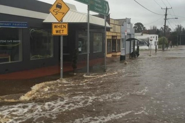
Image: Railton in flood 2016 (source: WMA Water)
ฉันควรทำอย่างไร
- ตรวจสอบแผนที่เพื่อดูว่าบ้านหรือธุรกิจของคุณอาจเกิดน้ำท่วมหรือไม่.
- ประเมินบ้านหรือธุรกิจของคุณและเตรียมพร้อมเพื่อลดความเสียหายจากน้ำท่วมที่อาจเกิดขึ้น.
- ตรวจสอบว่าคุณสามารถเดินทางกลับบ้าน ที่ทำงาน หรือโรงเรียนได้อย่างปลอดภัยในช่วงน้ำท่วมหรือไม่.
- จัดทำแผนฉุกเฉินประจำบ้าน พิจารณาว่าคุณจำเป็นต้องอพยพก่อนเกิดน้ำท่วมหรือไม่ ดู เตรียมพร้อมรับมือเหตุฉุกเฉิน– คู่มือสำหรับบุคคลและครัวเรือนในการเตรียมพร้อมรับมือกับเหตุฉุกเฉิน.
- If you are a primary producer, the Farm Flood Readiness Kit provides advice on preparing for a flood to help protect your business and stock.
- If you run a business or other organisation, check out the Tasmanian Government’s Emergency Ready Business tool online
- หากคุณอาจถูกกักตัวและคุณต้องเข้าถึงบริการ คุณอาจต้องอพยพออกไปก่อน.
- หากคุณกำลังตั้งแคมป์ในพื้นที่เสี่ยงต่อน้ำท่วม ควรติดตามข่าวสารอย่างใกล้ชิด และย้ายไปยังที่สูงทันทีหากคาดว่าจะมีน้ำท่วม.
น้ำท่วม เช่น ที่แสดงในแผนที่ หรืออาจจะหนักกว่านี้ จะเกิดขึ้นอีกครั้ง ไม่มีน้ำท่วมสองครั้งที่เหมือนกัน.
หากคุณอาศัยอยู่ในพื้นที่ลุ่มต่ำหรือใกล้ทางน้ำ บ้านของคุณอาจถูกน้ำท่วม แม้ว่าบ้านของคุณจะปลอดภัย คุณอาจต้องอ้อมไปรอบๆ บริเวณที่น้ำท่วม หรือทางเข้าบ้านของคุณอาจถูกตัดขาด ห้ามขับรถหรือเดินลุยเข้าไปในน้ำท่วมเด็ดขาด ถนนและสะพานอาจถูกพัดหายไปหรือไม่ปลอดภัย หลีกเลี่ยงการเดินทางในช่วงน้ำท่วม.
การรู้ว่าต้องทำอะไรสามารถช่วยชีวิตคุณและปกป้องทรัพย์สินของคุณได้ การมีแผนรับมือเหตุฉุกเฉินที่บ้านเป็นวิธีเตรียมพร้อมที่ดีที่สุดวิธีหนึ่ง กำหนดเหตุการณ์สภาพอากาศและปริมาณน้ำฝนที่จะกระตุ้นให้ลงมือปฏิบัติ.
ทำความเข้าใจคำเตือนและข้อมูลสำคัญ
เฝ้าระวังสิ่งที่เกิดขึ้นรอบตัวคุณ ตรวจสอบพยากรณ์อากาศ การสังเกตการณ์ และคำเตือนเป็นประจำ.
 |
คำแนะนำ (สีเหลือง): มีเหตุการณ์เกิดขึ้น ยังไม่มีอันตรายใดๆ โปรดติดตามความคืบหน้า เผื่อสถานการณ์เปลี่ยนแปลง. |
 |
ดูและดำเนินการ (สีส้ม): ระดับภัยคุกคามสูงขึ้น สภาพการณ์กำลังเปลี่ยนแปลงและคุณต้องเริ่มดำเนินการทันทีเพื่อปกป้องตัวเองและครอบครัว |
 |
คำเตือนฉุกเฉิน (สีแดง): คำเตือนฉุกเฉินคือระดับการเตือนภัยสูงสุด คุณอาจตกอยู่ในอันตรายและต้องดำเนินการทันที ความล่าช้าใดๆ ในตอนนี้จะทำให้ชีวิตของคุณตกอยู่ในความเสี่ยง. |
 |
อัปเดตชุมชน (สีน้ำเงิน): ข้อมูลและการอัปเดตเฉพาะสำหรับชุมชนที่ได้รับผลกระทบเกี่ยวกับเหตุการณ์หรืออุบัติการณ์เฉพาะ. |
| เหตุการณ์ (สีขาว): เหตุการณ์คือการเกิดขึ้นครั้งแรกของเหตุการณ์ก่อนที่จะกลายเป็นสัญญาณเตือนภัยฉุกเฉิน ทันทีที่ได้รับรายงานเหตุการณ์ TasALERT จะเผยแพร่ข้อมูลพื้นฐานรวมถึงประเภทและสถานที่เกิดเหตุ. |
Flood levels at Railton
Severe Weather Warnings and Flood Watches can forecast the amount of rain likely in an area. See detailed rain forecasts for Railton on the MetEye page on the BoM website www.bom.gov.au/tas/forecasts/railton.shtml .
24 hour rainfall totals at Railton can help you estimate how much flooding could occur. Flooding can also occur if a large amount of rain falls quickly in a short time, or it rains for days in a row.
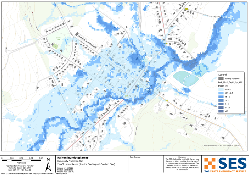
While no two floods are the same, the following describes what you can expect at different flood levels around Railton. Even if your property is not flooded, you need to think about access routes.
10% AEP (10% chance of occurring in any year)
Potential rainfall trigger: About 54 mm of rain in 6 hours @ Sheffield School Farm
What might happen:
-
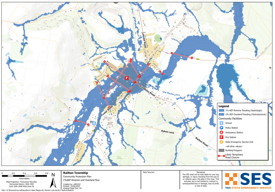
- Around 80 homes and businesses could flood. This includes parts of Crockers Sr, Esplanade, Foster St, Giblin St, Kimberley Rd, Latrobe Rd and Morrison St.
-
- Local roads such as Dowbiggin, Foster, Giblin Morrison Crockers, Esplanade, Railton, New Bed and Native Plains Roads may be affected by floodwater.
-
- Important places like the fire station, service station, childcare centre, Telstra exchange and some shops could flood or become isolated.
-
- With roads and railway lines cut, travel in and out of town may be affected.
-
- Parts of the town could be cut off from each other.
2% AEP (2% chance of occurring in any year)
Potential rainfall trigger: About 80 mm of rain in 6 hours @ Sheffield School Farm
What might happen, as per 10% AEP plus:
-
- Flooding spreads further around the town. Around 95 homes and businesses may be flooded or isolated. This includes some properties in Dowbiggin and Calder St.
-
- Some parts of Leake St and King St may flood.
1% AEP (1% chance of occurring in any year)
Potential rainfall trigger: About 86 mm of rain in 6 hours @ Sheffield School Farm
-
- Widespread flooding with around 100 houses at risk being flooded, similar to 2011.
-
- Some unflooded homes may be isolated due to surrounding water.
-
- Sewerage treatment plant near King Street may flood.
-
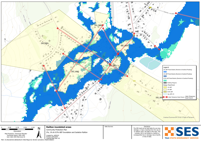
- Railton could be isolated for longer periods of time.
Go to TasALERT.com or listen to ABC local radio for detailed up to date information and advice during heavy rainfall events.
รู้ความเสี่ยงของคุณ เตรียมพร้อม ลดความเสี่ยงเท่าที่ทำได้ เชื่อมต่อกับผู้อื่น ตื่นตัวเสมอ และดำเนินการอย่างปลอดภัย.
ก่อนน้ำท่วม
เตรียมพร้อมรับมือเหตุฉุกเฉิน – คู่มือสำหรับบุคคลและครัวเรือนในการเตรียมพร้อมรับมือกับเหตุฉุกเฉิน.
1. รู้จักความเสี่ยงของคุณ
น้ำท่วมมักเกิดขึ้นในแทสเมเนียและอาจก่อให้เกิดความเสียหายในวงกว้างและรุนแรง ในช่วง 200 ปีที่ผ่านมา มีผู้เสียชีวิตจากเหตุน้ำท่วมในแทสเมเนีย 78 ราย คู่มือนี้จัดทำขึ้นเพื่อช่วยให้คุณเข้าใจเกี่ยวกับความเสี่ยงจากน้ำท่วมในพื้นที่ของคุณ.
2. เตรียมบ้านของคุณ
เตรียมแผนฉุกเฉินที่ครอบคลุมพายุและน้ำท่วม
การคิดถึงสิ่งที่คุณจะทำในระหว่างพายุหรือน้ำท่วม หมายถึงคุณมีความพร้อมมากขึ้น และทุกคนจะปลอดภัยยิ่งขึ้น จัดทำแผนฉุกเฉินที่ทุกคนในครัวเรือนของคุณเข้าใจ มีรายการตรวจสอบเพื่อช่วยให้คุณคิดถึงแผนของคุณ – ดู เตรียมพร้อมรับมือเหตุฉุกเฉิน – คู่มือสำหรับบุคคลและครัวเรือนในการเตรียมพร้อมรับมือกับเหตุฉุกเฉิน.
ตรวจสอบแผนของคุณอย่างสม่ำเสมอ และทดสอบโดยสมาชิกทุกคนในครอบครัวลองนึกถึงสถานการณ์น้ำท่วมที่อาจส่งผลกระทบต่อครอบครัวของคุณ.
เตรียมชุดอุปกรณ์ฉุกเฉิน
พร้อมไป
- วิทยุไฟฉายใช้แบตเตอรี่ พร้อมแบตเตอรี่สำรอง
- ข้อมูลสำคัญ เช่น แผนฉุกเฉินของคุณ
- รายการเบอร์โทรศัพท์ฉุกเฉิน
- อาหารและน้ำ
- ชุดปฐมพยาบาล
- ถุงมือยาง หรือหนังที่แข็งแรง
จัดกระเป๋าเมื่อจำเป็น
- เสื้อผ้าที่อบอุ่น รองเท้าที่ทนทาน หรือรองเท้าบูท
- ยา แว่นตา หรือสิ่งของจำเป็นอื่นๆ
- โทรศัพท์มือถือและที่ชาร์จโทรศัพท์
- อาหารสัตว์เลี้ยงและสิ่งอื่น ๆ ที่พวกเขาต้องการ
- รูปถ่ายและของที่ระลึกพิเศษ
- เงิน
- เอกสารสำคัญ ตัวอย่างเช่น
-
- เอกสารประกัน
-
- หนังสือเดินทางและ
-
- สูติบัตร
ทดสอบแบตเตอรี่วิทยุและไฟฉายเป็นประจำ.
3. ลดความเสี่ยงจากน้ำท่วมในบริเวณที่คุณสามารถทำได้
- คำนึงถึงพายุ น้ำท่วม และอันตรายอื่นๆ เมื่อซื้อ บำรุงรักษา หรือพัฒนาอสังหาริมทรัพย์.
- ตัดแต่งหรือโค่นต้นไม้และกิ่งก้านที่ยื่นเข้ามาเหนือบ้าน ธุรกิจ หรือใกล้สายไฟฟ้าบนทรัพย์สินของคุณ.
- รักษารางน้ำและท่อระบายน้ำของคุณให้โล่ง.
4. ติดต่อกับผู้อื่น
Know your neighbours and get involved in your community. A connected community is a safer and more resilient community in an emergency and can help everyone recover better afterwards. Check that family and neighbours are safe and aware of what’s happening.
ระหว่าง
5. Keep up to date
เฝ้าระวังสิ่งที่เกิดขึ้นรอบตัวคุณ ตรวจสอบพยากรณ์อากาศ การสังเกตการณ์ และคำเตือนเป็นประจำ.
- เดอะ กรมอุตุนิยมวิทยา เว็บไซต์.
6. Act Safe
- ดูแลเด็ก.
- เตรียมพร้อมรับมือการหยุดชะงักที่เป็นไปได้ของไฟฟ้า น้ำ หรืออินเทอร์เน็ต.
- ตรวจสอบชุดฉุกเฉินของคุณให้พร้อมใช้งาน.
- หลีกเลี่ยงพื้นที่ที่ถูกน้ำท่วม เช่น ท่อระบายน้ำ. ไม่ เดิน เล่น ขี่ หรือขับรถในน้ำท่วม คุณไม่สามารถมองเห็นสิ่งที่อยู่ใต้น้ำเสมอไป หรือน้ำมีความลึกหรือไหลเร็วเท่าใด ก็ตามเป็นเรื่องง่ายที่จะถูกพัดพาไปและจมน้ำในน้ำที่ไหลเร็วเพียง 20 ซม. น้ำท่วมอาจเป็นอันตรายได้.
เมื่อบ้านของคุณอาจถูกน้ำท่วม
- เก็บของใช้ในครัวเรือนไว้ในที่สูงเพื่อลดความเสียหายที่อาจเกิดขึ้น.
- ปิดไฟฟ้าและแก๊สหากสามารถทำได้อย่างปลอดภัย.
- วิธีที่ดีในการหยุดน้ำเสียไหลย้อนกลับเข้าบ้านของคุณคือการนำกระสอบทรายใส่ในถุงพลาสติก แล้วใช้กระสอบทรายเหล่านั้นอุดโถส้วมและปิดท่อระบายน้ำและอ่างล้างจาน.
- รีบออกไปก่อนที่คุณจะสามารถออกไปได้อย่างปลอดภัย.
หากคุณจำเป็นต้องอพยพ
- ปฏิบัติตามคำแนะนำจาก SES / ตำรวจแทสเมเนีย.
- นำชุดฉุกเฉินของคุณไปด้วย.
- ไปหาเพื่อนหรือญาติในที่ปลอดภัยกว่า หรือศูนย์พักพิง.
- บอกให้คนอื่นรู้ว่าคุณไปที่ไหน.
ดูแลสัตว์เลี้ยงของคุณ
You are responsible for your animals in an emergency. If you have pets and other animals it will take you longer to evacuate in a flood or other emergency. Move livestock from flood prone areas well before flood waters may rise. For more information see
หลีกเลี่ยงการเดินทางในช่วงที่มีพายุและหลังพายุ
- อย่าไปชมทิวทัศน์ จุดสนใจของนักท่องเที่ยวทำให้บริการฉุกเฉินล่าช้าและก่อให้เกิดอุบัติเหตุ.
- ระวังอันตรายต่างๆ เช่น
-
- น้ำท่วมถนน
-
- สายไฟฟ้าที่เสียหาย
-
- ดินถล่ม
-
- ถนนชำรุด
-
- ต้นไม้ล้มหรือหลังคาเหล็ก.
- ห้ามขับรถฝ่ากระแสน้ำท่วมโดยเด็ดขาด เหตุการณ์เสียชีวิตและต้องได้รับการช่วยเหลือจากน้ำท่วมส่วนใหญ่เกิดจากผู้ขับขี่พยายามขับรถฝ่ากระแสน้ำท่วม.
- ขับรถช้าๆ และเปิดไฟหน้ารถบนถนนที่ไม่อยู่ในบริเวณน้ำท่วม.
หลังจาก
- โปรดคอยรับฟังข่าวสารล่าสุดของ ABC Local Radio การเปิดถนนอีกครั้ง การประชุมชุมชน และอื่นๆ.
- หากท่านออกจากบ้านแล้ว ห้ามกลับเข้าบ้านจนกว่า SES หรือตำรวจแทสเมเนียจะแจ้งว่าปลอดภัย.
- ระมัดระวังอันตรายบนท้องถนน เช่น โคลนหรือเศษขยะบนถนน ถนน/สะพานที่ชำรุด และเจ้าหน้าที่ที่กำลังทำงานทำความสะอาดและซ่อมแซม.
หากบ้านของคุณได้รับความเสียหาย
- อยู่ในระดับพื้นดินขณะตรวจสอบความเสียหาย ระวังต้นไม้ที่โค่นล้ม กระจกแตก หลังคาหลุดลุ่ย หรืออันตรายอื่นๆ.
- สวมรองเท้าบูท ถุงมือ และเสื้อผ้าป้องกันที่แข็งแรง.
- ใช้ไฟฉาย ห้ามใช้ไม้ขีดไฟหรือเทียนไขภายในอาคารที่ถูกน้ำท่วม.
- ต้มน้ำดื่มทุกครั้งจนกว่าจะได้รับแจ้งว่าน้ำประปาปลอดภัยอีกครั้ง.
- Do not turn on it is tested by a licensed electrician or gas fitter for safety.
- หากบ้านของคุณได้รับความเสียหาย และคุณต้องไปพักที่อื่น ให้นำชุดอุปกรณ์ฉุกเฉินและสัตว์เลี้ยงของคุณไปด้วย
- ถ่ายรูปความเสียหายที่พบ หากทำได้อย่างปลอดภัย แล้วติดต่อบริษัทประกันภัยของคุณ.
- ดูแลเด็ก.
- ตรวจสอบเพื่อนบ้านว่าโอเคหรือเปล่า.
สำหรับข้อมูลเพิ่มเติม ไปที่ www.ses.tas.gov.au
การรับทราบข้อมูลและข้อมูลเพิ่มเติม
Current warnings – TasALERT.com
Emergency Broadcasters – สถานีวิทยุ ABC ในพื้นที่ของคุณ
TASSES Social Media – facebook.com/sestasmania
การเตรียมพร้อมรับมือสถานการณ์น้ำท่วมฉุกเฉิน ses.tas.gov.au/flood-plan/
บริการถ่ายทอดแห่งชาติ (NRS) relayservice.gov.au
Emergency Broadcasters ABC East Devonport 100.5FM or listen online.
สภาเคนทิช www.kentish.tas.gov.au 6491 0200
Developed in partnership with Kentish Council.
ข้อจำกัดความรับผิด
The maps show potential flooding risks from consistent levels of rainfall across catchments, such as a 1% Annual Exceedance Probability (AEP). In flooding events, rainfall is likely to be more inconsistent across a catchment, so these flood maps should be considered indicative only. The mapped areas of flood risk show higher probability of inundation. Other areas have lower probability of flooding, but in severe and rare events (rarer than 1%AEP), other lower areas may be also at risk of inundation.
ข้อมูลในคู่มือนี้เป็นข้อมูล ณ วันที่เผยแพร่ แม้ว่าจะได้ใช้ความพยายามอย่างเต็มที่เพื่อให้แน่ใจว่าข้อมูลที่นำเสนอมีความถูกต้องและเชื่อถือได้ แต่หน่วยบริการภาวะฉุกเฉินของรัฐจะไม่รับผิดชอบต่อข้อผิดพลาดหรือการละเว้นของข้อมูล โปรดดูมาตรฐาน ข้อความสงวนลิขสิทธิ์และข้อจำกัดความรับผิดชอบของรัฐบาลแทสเมเนีย สำหรับรายละเอียดเพิ่มเติม.
