คู่มืออุทกภัยของRokeby, Oakdowns และ Clarendon Vale
ข้อมูลน้ำท่วมจากแม่น้ำ น้ำท่วมจากฝนตกโดยตรง และน้ำท่วมชายฝั่งสำหรับชานเมืองบน Clarence Plains
Draft version 0.1b September 2025 for community input – email ses@ses.tas.gov.au – PDF version
เพื่อดูแผนที่ในรายละเอียดมากขึ้น, ดูแผนที่น้ำท่วมเชิงยุทธศาสตร์ของแทสเมเนีย.
ทำความเข้าใจความเสี่ยงน้ำท่วมและเตรียมพร้อม
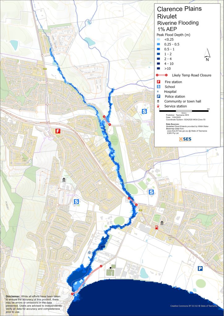
มีทางน้ำสามสายบนที่ราบแคลเรนซ์
- คลารอนซ์ เพลนส์ ริเวอเล็ต
- สตอเกลล์ครีก และ
- ซอพิต กัลลี.
ในการเกิดอุทกภัยครั้งใหญ่ ทางน้ำเหล่านี้จะมีขนาดและความเร็วเพิ่มขึ้น อาจเอ่อล้นตลิ่งและท่วมถนนในท้องถิ่น รวมถึงบ้านเรือนบางหลัง.
บางส่วนของพื้นที่นี้อาจมีความเสี่ยงต่อการท่วมและการกัดเซาะชายฝั่ง หากมีฝนตกหนักในช่วงน้ำขึ้น น้ำท่วมอาจสูงขึ้นและกินเวลานานขึ้นในพื้นที่ชายฝั่ง ปากแม่น้ำ Clarence Plains Rivulet และสะพานบนถนน Droughty Point Rd มีความเสี่ยงเป็นพิเศษจากน้ำท่วมประเภทนี้.
ถนนหลายสายอาจเกิดน้ำท่วมได้ ได้แก่:
- ถนนโรว์บี
- ถนนกู๊ดวินส์
- ถนนเซาท์อาร์ม
- ถนนม็อคริดจ์
- ถนนและซอยอื่นๆ ในท้องถิ่น
การเดินทางในพื้นที่อาจมีความยากลำบากหรือไม่สามารถทำได้จนกว่าถนนจะปลอดภัย. หากคุณปลอดภัยที่บ้านหรือที่อื่น ๆ โดยทั่วไปแล้วคุณควรอยู่ที่นั่นจนกว่าน้ำจะลดลง ยกเว้นกรณีฉุกเฉิน. หากคุณจำเป็นต้องอพยพ คุณควรออกจากบ้านก่อนที่น้ำจะท่วมสูงขึ้น.
ฉันควรทำอย่างไร
- ตรวจสอบแผนที่เพื่อดูว่าบ้านหรือธุรกิจของคุณอาจเกิดน้ำท่วมหรือไม่.
- ประเมินบ้านหรือธุรกิจของคุณและเตรียมพร้อมเพื่อลดความเสียหายจากน้ำท่วมที่อาจเกิดขึ้น.
- ตรวจสอบว่าคุณสามารถเดินทางกลับบ้าน ที่ทำงาน หรือโรงเรียนได้อย่างปลอดภัยในช่วงน้ำท่วมหรือไม่.
- จัดทำแผนฉุกเฉินประจำบ้าน พิจารณาว่าคุณจำเป็นต้องอพยพก่อนเกิดน้ำท่วมหรือไม่ ดู เตรียมพร้อมรับมือเหตุฉุกเฉิน– คู่มือสำหรับบุคคลและครัวเรือนในการเตรียมพร้อมรับมือกับเหตุฉุกเฉิน.
- If you are a primary producer, the Farm Flood Readiness Kit provides advice on preparing for a flood to help protect your business and stock.
- If you run a business or other organisation, check out the Tasmanian Government’s Emergency Ready Business tool online
- หากคุณอาจถูกกักตัวและคุณต้องเข้าถึงบริการ คุณอาจต้องอพยพออกไปก่อน.
- หากคุณกำลังตั้งแคมป์ในพื้นที่เสี่ยงต่อน้ำท่วม ควรติดตามข่าวสารอย่างใกล้ชิด และย้ายไปยังที่สูงทันทีหากคาดว่าจะมีน้ำท่วม.
น้ำท่วม เช่น ที่แสดงในแผนที่ หรืออาจจะหนักกว่านี้ จะเกิดขึ้นอีกครั้ง ไม่มีน้ำท่วมสองครั้งที่เหมือนกัน.
หากคุณอาศัยอยู่ในพื้นที่ลุ่มต่ำหรือใกล้ทางน้ำ บ้านของคุณอาจถูกน้ำท่วม แม้ว่าบ้านของคุณจะปลอดภัย คุณอาจต้องอ้อมไปรอบๆ บริเวณที่น้ำท่วม หรือทางเข้าบ้านของคุณอาจถูกตัดขาด ห้ามขับรถหรือเดินลุยเข้าไปในน้ำท่วมเด็ดขาด ถนนและสะพานอาจถูกพัดหายไปหรือไม่ปลอดภัย หลีกเลี่ยงการเดินทางในช่วงน้ำท่วม.
การรู้ว่าต้องทำอะไรสามารถช่วยชีวิตคุณและปกป้องทรัพย์สินของคุณได้ การมีแผนรับมือเหตุฉุกเฉินที่บ้านเป็นวิธีเตรียมพร้อมที่ดีที่สุดวิธีหนึ่ง กำหนดเหตุการณ์สภาพอากาศและปริมาณน้ำฝนที่จะกระตุ้นให้ลงมือปฏิบัติ.
กรมอุตุนิยมวิทยา พยากรณ์, การเตือน, และการสังเกตการณ์
สำนักออก ประกาศเตือนภัยน้ำท่วม, ประกาศเตือนสภาพอากาศรุนแรง และ/หรือ ประกาศเตือนพายุฝนฟ้าคะนองสำหรับฝนตกหนักที่อาจทำให้เกิดน้ำท่วมฉับพลัน เมื่อไรก็ตาม ฝนตกหนัก คาดว่าจะเกิดขึ้นในพื้นที่ ระยะเวลาระหว่างการเตือนภัยกับฝนตกหนักอาจแตกต่างกันไปตั้งแต่หนึ่งชั่วโมงถึง 24 ชั่วโมงขึ้นไป.
ไม่มีเครื่องวัดระดับน้ำบนทางน้ำในบริเวณนี้.
การสังเกตปริมาณน้ำฝน ที่สนามบินโฮบาร์ต, โฮบาร์ต (ถนนเอลเลอสลี) และมาตรวัดน้ำฝนใกล้เคียงอื่นๆ สามารถบ่งชี้ความเสี่ยงน้ำท่วมได้ เนื่องจากมีเวลาเตือนภัยสั้นมาก จึงควรปฏิบัติตามคำเตือนของ BoM ล่วงหน้า แทนที่จะรอการแจ้งเตือนน้ำท่วมระหว่างฝนตก.
เดอะ เรดาร์ยอดเขาคูเนีย is useful to be aware in real-time where heavy rainfall is falling. Radar Rainfall estimates can also fill in gaps in areas where there are no rainfall stations.
ทำความเข้าใจคำเตือนและข้อมูลสำคัญ
เฝ้าระวังสิ่งที่เกิดขึ้นรอบตัวคุณ ตรวจสอบพยากรณ์อากาศ การสังเกตการณ์ และคำเตือนเป็นประจำ.
 |
คำแนะนำ (สีเหลือง): มีเหตุการณ์เกิดขึ้น ยังไม่มีอันตรายใดๆ โปรดติดตามความคืบหน้า เผื่อสถานการณ์เปลี่ยนแปลง. |
 |
ดูและดำเนินการ (สีส้ม): ระดับภัยคุกคามสูงขึ้น สภาพการณ์กำลังเปลี่ยนแปลงและคุณต้องเริ่มดำเนินการทันทีเพื่อปกป้องตัวเองและครอบครัว |
 |
คำเตือนฉุกเฉิน (สีแดง): คำเตือนฉุกเฉินคือระดับการเตือนภัยสูงสุด คุณอาจตกอยู่ในอันตรายและต้องดำเนินการทันที ความล่าช้าใดๆ ในตอนนี้จะทำให้ชีวิตของคุณตกอยู่ในความเสี่ยง. |
 |
อัปเดตชุมชน (สีน้ำเงิน): ข้อมูลและการอัปเดตเฉพาะสำหรับชุมชนที่ได้รับผลกระทบเกี่ยวกับเหตุการณ์หรืออุบัติการณ์เฉพาะ. |
| เหตุการณ์ (สีขาว): เหตุการณ์คือการเกิดขึ้นครั้งแรกของเหตุการณ์ก่อนที่จะกลายเป็นสัญญาณเตือนภัยฉุกเฉิน ทันทีที่ได้รับรายงานเหตุการณ์ TasALERT จะเผยแพร่ข้อมูลพื้นฐานรวมถึงประเภทและสถานที่เกิดเหตุ. |
ระดับน้ำท่วม
แม้ว่าน้ำท่วมแต่ละครั้งจะไม่เหมือนกัน แต่ต่อไปนี้คือสิ่งที่คุณคาดหวังได้จากระดับน้ำท่วมที่แตกต่างกันในพื้นที่ แม้ว่าทรัพย์สินของคุณจะไม่ถูกน้ำท่วม แต่คุณก็ต้องคำนึงถึงการเข้าถึงด้วย ระดับน้ำฝนที่แตกต่างกันสามารถทำให้น้ำท่วมได้ ขึ้นอยู่กับความรุนแรง ระยะเวลา และพื้นดินมีความชื้นมากน้อยเพียงใดก่อนหน้านี้ และปริมาณน้ำฝนที่ตก.
น้ำท่วมเล็กน้อย
A minor flood can inundate low lying parkland, gardens, orchards and paddocks. Vehicles, animals and equipment should be moved. There may also be some flooding across minor roads and walking tracks.
น้ำท่วมปานกลาง
เกิดน้ำท่วมขังในพื้นที่สวนสาธารณะมากขึ้น และอาคารบางหลังอาจได้รับผลกระทบสูงเกินระดับพื้นอาคาร บ้านเรือนบางหลังอาจถูกตัดขาดเป็นเวลาสองสามชั่วโมงเนื่องจากถนนสายรองมีน้ำท่วม.
น้ำท่วมใหญ่
พื้นที่ขนาดใหญ่กำลังประสบภาวะน้ำท่วม อาคารหลายแห่งอาจได้รับผลกระทบเหนือระดับพื้นดิน ทรัพย์สินและเมืองต่างๆ อาจถูกตัดขาด และเส้นทางรถไฟสายหลักกับถนนจะถูกปิด การอพยพอาจมีความจำเป็น บริการสาธารณูปโภคอาจได้รับผลกระทบ.
ระดับน้ำท่วมในลักษณะนี้ อาจเป็นผลมาจากปริมาณน้ำฝนประมาณ 120 มิลลิเมตร ตกในระยะเวลา 12 ชั่วโมงที่สนามบินโฮบาร์ต เป็นต้น น้ำท่วมอาจทำให้ถนน Rokeby Rd และ South Arm Rd ถูกปิด ส่งผลจำกัดการสัญจรและการขนส่ง.
-
- พื้นที่ของคลินิกโฮบาร์ตและโรงเรียนในบริเวณนี้อาจเกิดน้ำท่วม,
-
- สะพานข้ามลำธารแคลเรนซ์เพลนส์อาจอยู่ใต้น้ำ.
-
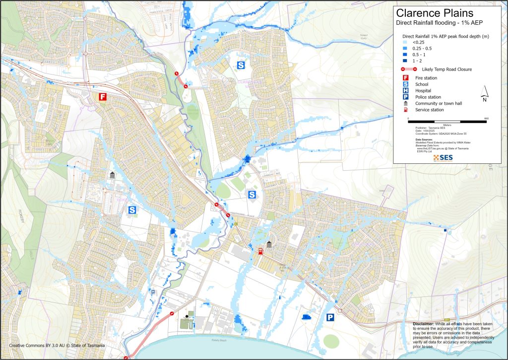
- ขึ้นอยู่กับพื้นที่ที่เกิดฝนตก สภาวะน้ำท่วมฉับพลันจากน้ำฝนโดยตรงและน้ำท่าอาจทำให้เกิดน้ำท่วมขังเฉพาะแห่งได้.
Go to TasALERT.com or listen to ABC local radio for detailed up to date information and advice during heavy rainfall events.
รู้ความเสี่ยงของคุณ เตรียมพร้อม ลดความเสี่ยงเท่าที่ทำได้ เชื่อมต่อกับผู้อื่น ตื่นตัวเสมอ และดำเนินการอย่างปลอดภัย.
ก่อนน้ำท่วม
เตรียมพร้อมรับมือเหตุฉุกเฉิน – คู่มือสำหรับบุคคลและครัวเรือนในการเตรียมพร้อมรับมือกับเหตุฉุกเฉิน.
1. รู้จักความเสี่ยงของคุณ
น้ำท่วมมักเกิดขึ้นในแทสเมเนียและอาจก่อให้เกิดความเสียหายในวงกว้างและรุนแรง ในช่วง 200 ปีที่ผ่านมา มีผู้เสียชีวิตจากเหตุน้ำท่วมในแทสเมเนีย 78 ราย คู่มือนี้จัดทำขึ้นเพื่อช่วยให้คุณเข้าใจเกี่ยวกับความเสี่ยงจากน้ำท่วมในพื้นที่ของคุณ.
2. เตรียมบ้านของคุณ
เตรียมแผนฉุกเฉินที่ครอบคลุมพายุและน้ำท่วม
การคิดถึงสิ่งที่คุณจะทำในระหว่างพายุหรือน้ำท่วม หมายถึงคุณมีความพร้อมมากขึ้น และทุกคนจะปลอดภัยยิ่งขึ้น จัดทำแผนฉุกเฉินที่ทุกคนในครัวเรือนของคุณเข้าใจ มีรายการตรวจสอบเพื่อช่วยให้คุณคิดถึงแผนของคุณ – ดู เตรียมพร้อมรับมือเหตุฉุกเฉิน – คู่มือสำหรับบุคคลและครัวเรือนในการเตรียมพร้อมรับมือกับเหตุฉุกเฉิน.
ตรวจสอบแผนของคุณอย่างสม่ำเสมอ และทดสอบโดยสมาชิกทุกคนในครอบครัวลองนึกถึงสถานการณ์น้ำท่วมที่อาจส่งผลกระทบต่อครอบครัวของคุณ.
เตรียมชุดอุปกรณ์ฉุกเฉิน
พร้อมไป
- วิทยุไฟฉายใช้แบตเตอรี่ พร้อมแบตเตอรี่สำรอง
- ข้อมูลสำคัญ เช่น แผนฉุกเฉินของคุณ
- รายการเบอร์โทรศัพท์ฉุกเฉิน
- อาหารและน้ำ
- ชุดปฐมพยาบาล
- ถุงมือยาง หรือหนังที่แข็งแรง
จัดกระเป๋าเมื่อจำเป็น
- เสื้อผ้าที่อบอุ่น รองเท้าที่ทนทาน หรือรองเท้าบูท
- ยา แว่นตา หรือสิ่งของจำเป็นอื่นๆ
- โทรศัพท์มือถือและที่ชาร์จโทรศัพท์
- อาหารสัตว์เลี้ยงและสิ่งอื่น ๆ ที่พวกเขาต้องการ
- รูปถ่ายและของที่ระลึกพิเศษ
- เงิน
- เอกสารสำคัญ ตัวอย่างเช่น
-
- เอกสารประกัน
-
- หนังสือเดินทางและ
-
- สูติบัตร
ทดสอบแบตเตอรี่วิทยุและไฟฉายเป็นประจำ.
3. ลดความเสี่ยงจากน้ำท่วมในบริเวณที่คุณสามารถทำได้
- คำนึงถึงพายุ น้ำท่วม และอันตรายอื่นๆ เมื่อซื้อ บำรุงรักษา หรือพัฒนาอสังหาริมทรัพย์.
- ตัดแต่งหรือโค่นต้นไม้และกิ่งก้านที่ยื่นเข้ามาเหนือบ้าน ธุรกิจ หรือใกล้สายไฟฟ้าบนทรัพย์สินของคุณ.
- รักษารางน้ำและท่อระบายน้ำของคุณให้โล่ง.
4. ติดต่อกับผู้อื่น
Know your neighbours and get involved in your community. A connected community is a safer and more resilient community in an emergency and can help everyone recover better afterwards. Check that family and neighbours are safe and aware of what’s happening.
ระหว่าง
5. Keep up to date
เฝ้าระวังสิ่งที่เกิดขึ้นรอบตัวคุณ ตรวจสอบพยากรณ์อากาศ การสังเกตการณ์ และคำเตือนเป็นประจำ.
- เดอะ กรมอุตุนิยมวิทยา เว็บไซต์.
6. Act Safe
- ดูแลเด็ก.
- เตรียมพร้อมรับมือการหยุดชะงักที่เป็นไปได้ของไฟฟ้า น้ำ หรืออินเทอร์เน็ต.
- ตรวจสอบชุดฉุกเฉินของคุณให้พร้อมใช้งาน.
- หลีกเลี่ยงพื้นที่ที่ถูกน้ำท่วม เช่น ท่อระบายน้ำ. ไม่ เดิน เล่น ขี่ หรือขับรถในน้ำท่วม คุณไม่สามารถมองเห็นสิ่งที่อยู่ใต้น้ำเสมอไป หรือน้ำมีความลึกหรือไหลเร็วเท่าใด ก็ตามเป็นเรื่องง่ายที่จะถูกพัดพาไปและจมน้ำในน้ำที่ไหลเร็วเพียง 20 ซม. น้ำท่วมอาจเป็นอันตรายได้.
เมื่อบ้านของคุณอาจถูกน้ำท่วม
- เก็บของใช้ในครัวเรือนไว้ในที่สูงเพื่อลดความเสียหายที่อาจเกิดขึ้น.
- ปิดไฟฟ้าและแก๊สหากสามารถทำได้อย่างปลอดภัย.
- วิธีที่ดีในการหยุดน้ำเสียไหลย้อนกลับเข้าบ้านของคุณคือการนำกระสอบทรายใส่ในถุงพลาสติก แล้วใช้กระสอบทรายเหล่านั้นอุดโถส้วมและปิดท่อระบายน้ำและอ่างล้างจาน.
- รีบออกไปก่อนที่คุณจะสามารถออกไปได้อย่างปลอดภัย.
หากคุณจำเป็นต้องอพยพ
- ปฏิบัติตามคำแนะนำจาก SES / ตำรวจแทสเมเนีย.
- นำชุดฉุกเฉินของคุณไปด้วย.
- ไปหาเพื่อนหรือญาติในที่ปลอดภัยกว่า หรือศูนย์พักพิง.
- บอกให้คนอื่นรู้ว่าคุณไปที่ไหน.
ดูแลสัตว์เลี้ยงของคุณ
You are responsible for your animals in an emergency. If you have pets and other animals it will take you longer to evacuate in a flood or other emergency. Move livestock from flood prone areas well before flood waters may rise. For more information see
หลีกเลี่ยงการเดินทางในช่วงที่มีพายุและหลังพายุ
- อย่าไปชมทิวทัศน์ จุดสนใจของนักท่องเที่ยวทำให้บริการฉุกเฉินล่าช้าและก่อให้เกิดอุบัติเหตุ.
- ระวังอันตรายต่างๆ เช่น
-
- น้ำท่วมถนน
-
- สายไฟฟ้าที่เสียหาย
-
- ดินถล่ม
-
- ถนนชำรุด
-
- ต้นไม้ล้มหรือหลังคาเหล็ก.
- ห้ามขับรถฝ่ากระแสน้ำท่วมโดยเด็ดขาด เหตุการณ์เสียชีวิตและต้องได้รับการช่วยเหลือจากน้ำท่วมส่วนใหญ่เกิดจากผู้ขับขี่พยายามขับรถฝ่ากระแสน้ำท่วม.
- ขับรถช้าๆ และเปิดไฟหน้ารถบนถนนที่ไม่อยู่ในบริเวณน้ำท่วม.
หลังจาก
- โปรดคอยรับฟังข่าวสารล่าสุดของ ABC Local Radio การเปิดถนนอีกครั้ง การประชุมชุมชน และอื่นๆ.
- หากท่านออกจากบ้านแล้ว ห้ามกลับเข้าบ้านจนกว่า SES หรือตำรวจแทสเมเนียจะแจ้งว่าปลอดภัย.
- ระมัดระวังอันตรายบนท้องถนน เช่น โคลนหรือเศษขยะบนถนน ถนน/สะพานที่ชำรุด และเจ้าหน้าที่ที่กำลังทำงานทำความสะอาดและซ่อมแซม.
หากบ้านของคุณได้รับความเสียหาย
- อยู่ในระดับพื้นดินขณะตรวจสอบความเสียหาย ระวังต้นไม้ที่โค่นล้ม กระจกแตก หลังคาหลุดลุ่ย หรืออันตรายอื่นๆ.
- สวมรองเท้าบูท ถุงมือ และเสื้อผ้าป้องกันที่แข็งแรง.
- ใช้ไฟฉาย ห้ามใช้ไม้ขีดไฟหรือเทียนไขภายในอาคารที่ถูกน้ำท่วม.
- ต้มน้ำดื่มทุกครั้งจนกว่าจะได้รับแจ้งว่าน้ำประปาปลอดภัยอีกครั้ง.
- Do not turn on it is tested by a licensed electrician or gas fitter for safety.
- หากบ้านของคุณได้รับความเสียหาย และคุณต้องไปพักที่อื่น ให้นำชุดอุปกรณ์ฉุกเฉินและสัตว์เลี้ยงของคุณไปด้วย
- ถ่ายรูปความเสียหายที่พบ หากทำได้อย่างปลอดภัย แล้วติดต่อบริษัทประกันภัยของคุณ.
- ดูแลเด็ก.
- ตรวจสอบเพื่อนบ้านว่าโอเคหรือเปล่า.
สำหรับข้อมูลเพิ่มเติม ไปที่ www.ses.tas.gov.au
การรับทราบข้อมูลและข้อมูลเพิ่มเติม
Current warnings – TasALERT.com
Emergency Broadcasters – สถานีวิทยุ ABC ในพื้นที่ของคุณ
TASSES Social Media – facebook.com/sestasmania
การเตรียมพร้อมรับมือสถานการณ์น้ำท่วมฉุกเฉิน ses.tas.gov.au/flood-plan/
บริการถ่ายทอดแห่งชาติ (NRS) relayservice.gov.au
Local Emergency Broadcasters ABC 936AM
Clarence City Council ccc.tas.gov.au clarence@ccc.tas.gov.au 6217 9500
โปรดทราบ
แผนที่ในแผนงานนี้แสดงข้อมูลจากโครงการ Tasmanian Strategic Flood Mapping (TSFM) คุณสามารถสำรวจข้อมูลนี้ได้ด้วยชั้นข้อมูล Flood Hazard Data บน www.thelist.tas.gov.au.
สภาเทศบาลเมืองแคลเรนซ์มีการศึกษาเรื่องน้ำท่วมอย่างละเอียดสำหรับพื้นที่เหล่านี้ โปรดดู www.ccc.tas.gov.au/living/your neighbourhood/flooding/. ข้อมูล CCC ประกอบด้วยการคาดการณ์การเปลี่ยนแปลงสภาพภูมิอากาศ แสดงให้เห็นน้ำท่วมในความลึกที่ตื้นกว่า ดังนั้น ขอบเขตของน้ำท่วมจึงแตกต่างกันอย่างมาก และโดยทั่วไปจะใหญ่กว่าขอบเขต TSFM ที่แสดงในแผนที่ด้านล่าง ข้อมูลนี้อิงตามค่าเฉลี่ยปริมาณน้ำฝนในอดีต.
ข้อจำกัดความรับผิด
The maps show potential flooding risks from consistent levels of rainfall across catchments, such as a 1% Annual Exceedance Probability (AEP). In flooding events, rainfall is likely to be more inconsistent across a catchment, so these flood maps should be considered indicative only. The mapped areas of flood risk show higher probability of inundation. Other areas have lower probability of flooding, but in severe and rare events (rarer than 1%AEP), other lower areas may be also at risk of inundation.
ข้อมูลในคู่มือนี้เป็นข้อมูล ณ วันที่เผยแพร่ แม้ว่าจะได้ใช้ความพยายามอย่างเต็มที่เพื่อให้แน่ใจว่าข้อมูลที่นำเสนอมีความถูกต้องและเชื่อถือได้ แต่หน่วยบริการภาวะฉุกเฉินของรัฐจะไม่รับผิดชอบต่อข้อผิดพลาดหรือการละเว้นของข้อมูล โปรดดูมาตรฐาน ข้อความสงวนลิขสิทธิ์และข้อจำกัดความรับผิดชอบของรัฐบาลแทสเมเนีย สำหรับรายละเอียดเพิ่มเติม.
