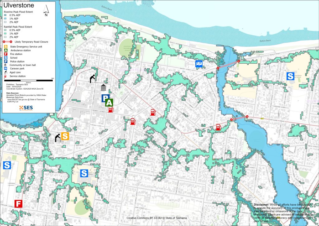
อูลเวอร์สตันและบริเวณโดยรอบ
ข้อมูลน้ำท่วมและน้ำทะเลหนุนสำหรับทรัพย์สินที่อยู่ริมแม่น้ำกอว์เลอร์, บัตตันส์ครีก และทางน้ำสายเล็กอื่นๆ ดูคู่มือที่เกี่ยวข้องสำหรับ เวสต์ อัลเวอร์สโตน.
Version 1.1 January 2026 – PDF version
เพื่อดูแผนที่ในรายละเอียดมากขึ้น, ดูแผนที่น้ำท่วมเชิงยุทธศาสตร์ของแทสเมเนีย.
รู้ความเสี่ยงน้ำท่วมของคุณและเตรียมพร้อม
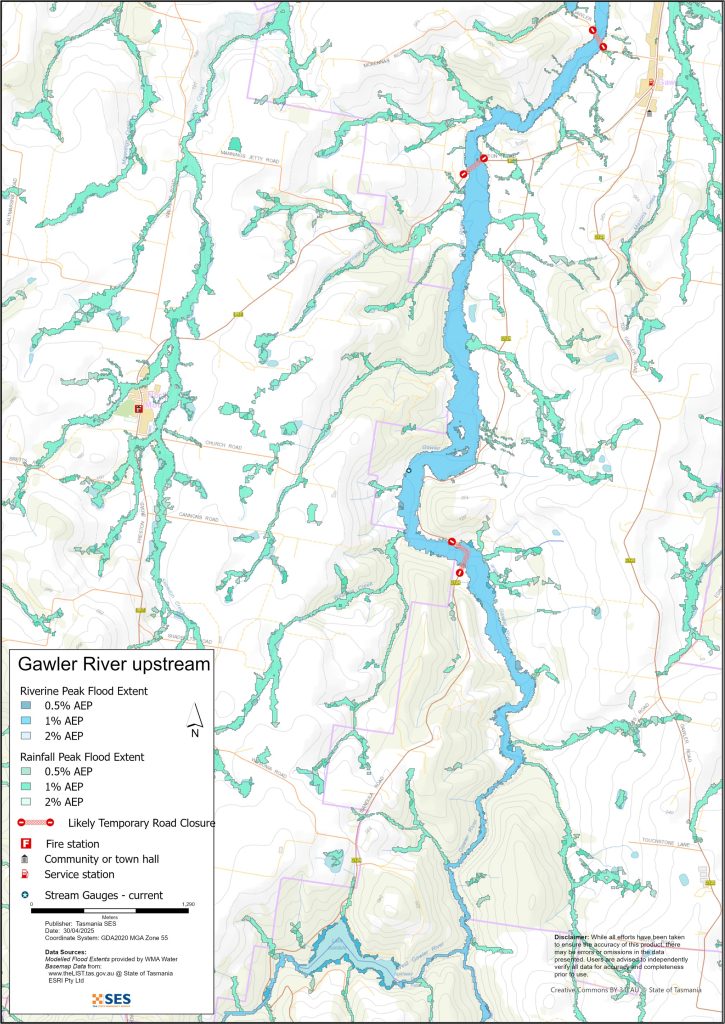
พื้นที่นี้มีทางน้ำหลักสองสายที่อาจเกิดน้ำท่วม ได้แก่ แม่น้ำกอว์เลอร์ (Gawler River) และบัตตันส์ครีก (Buttons Creek) นอกจากนี้ยังมีลำธารเล็กๆ และทางน้ำไหลหลากบนพื้นผิวที่อาจเกิดน้ำท่วมได้.
ในกรณีที่เกิดน้ำท่วมใหญ่ ลำห้วย Buttons อาจเกิดน้ำท่วมได้
- ถนนเลียบหาดและทรัพย์สินใกล้เคียงบนถนนเลียบหาดและถนนทัคเกอร์
- ฮิวโก้ คอร์ต
- อสังหาริมทรัพย์ที่ปลายสุดของถนน Dysons Lane.
สวนสาธารณะและสนามกีฬาในเมืองอัลเวอร์สโตนจะถูกน้ำท่วม รวมถึง
- เฮย์วูดส์ รีเซิร์ฟ และสโมสรคริกเก็ต บนถนนพาร์สันส์
- สวนไบเซนเทนเนียล, สวนชรอปเชียร์ และสวนแอนแซค ริมแม่น้ำเลเวน
- สนามกีฬาอูลเวอร์สตันและสวนสาธารณะแฟร์เวย์ บนถนนวอเตอร์
- ลานจอดคาราวานบนถนนวอเตอร์อาจถูกน้ำท่วมหากมีฝนตกหนักในเมืองอัลเวอร์สโตน.
ฝนตกหนักในพื้นที่อาจทำให้เกิดน้ำท่วมทั่วทั้งเมืองอัลเวอร์สโตน แม่น้ำเมสันส์อาจทำให้น้ำท่วมถนนกอว์เลอร์และถนนอไดฮี ทางใต้ของทางหลวงในอัลเวอร์สโตน น้ำท่วมลักษณะนี้มักกินเวลาเพียงช่วงสั้นๆ.
น้ำท่วมในแม่น้ำกอว์เลอร์อาจท่วมทางเข้าบ้าน ถนน และสะพานบน
- ถนนเวสต์ กอว์เลอร์
- ถนนเพรสตัน และ
- ถนนอีซานดูลา
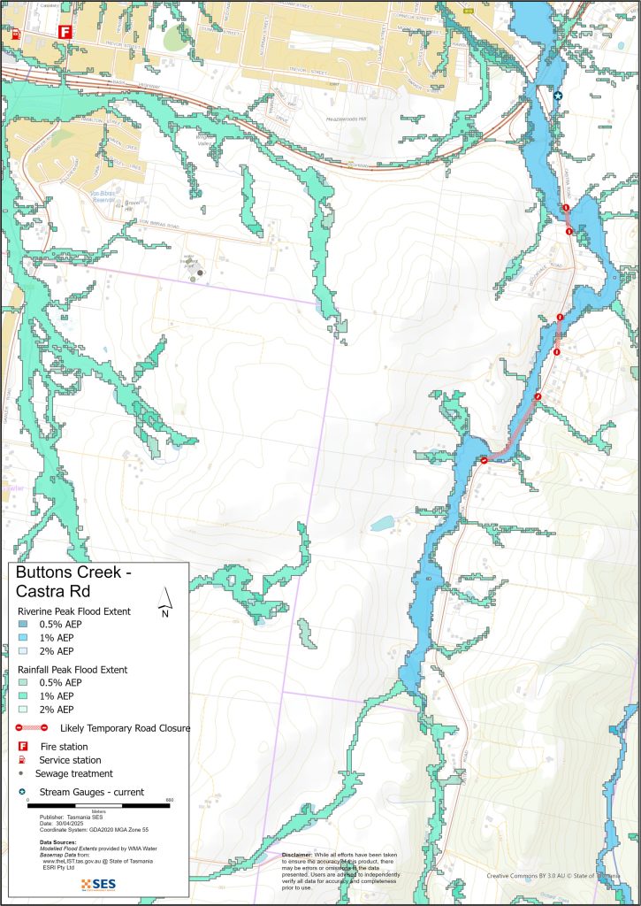
น้ำท่วมในส่วนบนของลำธาร Buttons อาจท่วมทางเข้าบ้าน ถนน และสะพานบน
- ถนนแคสทรา
- ถนนเอดินบะระ (แอบบอตแชม).
นี่อาจหมายความว่าอสังหาริมทรัพย์และชุมชนจะถูกตัดขาด โดยขึ้นอยู่กับสภาพของเส้นทางสำรอง.
แม้ว่าบ้านของคุณจะไม่ถูกน้ำท่วม คุณก็ควรเตรียมพร้อมสำหรับการถูกตัดขาด รวมถึงความเป็นไปได้ที่จะเกิดไฟฟ้าดับและระบบโทรคมนาคมขัดข้อง.
การเดินทางในพื้นที่อาจมีความยากลำบากหรือไม่สามารถทำได้จนกว่าถนนจะปลอดภัย. หากคุณปลอดภัยที่บ้านหรือที่อื่น ๆ โดยทั่วไปแล้วคุณควรอยู่ที่นั่นจนกว่าน้ำจะลดลง ยกเว้นกรณีฉุกเฉิน. หากคุณจำเป็นต้องอพยพ คุณควรออกจากบ้านก่อนที่น้ำจะท่วมสูงขึ้น.
แผนที่ในคู่มือนี้แสดงระดับน้ำท่วมที่มีโอกาสเกิดขึ้น 0.5%, 1% และ 2% ในแต่ละปี ซึ่งเรียกว่า Annual Exceedance Probability (AEP) คุณมีแนวโน้มที่จะประสบกับน้ำท่วมเช่นเดียวกับที่แสดงในแผนที่ในช่วงชีวิตของคุณ ชาวแทสมาเนียจำเป็นต้องเตรียมพร้อมสำหรับเหตุการณ์น้ำท่วมที่อาจไม่เกิดขึ้นบ่อย รวมถึงน้ำท่วมเล็กน้อยที่พวกเขาอาจเคยประสบมาก่อน.
ไปที่ TasALERT.com หรือฟังวิทยุ ABC ท้องถิ่น 91.7 FM เพื่อรับคำเตือนและคำแนะนำ.
คุณมีความเสี่ยงต่อน้ำท่วมหรือไม่
เมือง Ulverstone และพื้นที่โดยรอบได้รับผลกระทบจากน้ำท่วมใหญ่ในปี 1970, 2005, 2011, 2016 และ 2022 เหตุการณ์น้ำท่วมเหล่านี้ได้สร้างความเสียหายและทำลายสะพานและถนน รวมถึงท่วมบ้านเรือน.

ฉันควรทำอย่างไร
- ตรวจสอบแผนที่เพื่อดูว่าบ้านหรือธุรกิจของคุณอาจเกิดน้ำท่วมหรือไม่.
- ประเมินบ้านหรือธุรกิจของคุณและเตรียมพร้อมเพื่อลดความเสียหายจากน้ำท่วมที่อาจเกิดขึ้น.
- ตรวจสอบว่าคุณสามารถเดินทางกลับบ้าน ที่ทำงาน หรือโรงเรียนได้อย่างปลอดภัยในช่วงน้ำท่วมหรือไม่.
- จัดทำแผนฉุกเฉินประจำบ้าน พิจารณาว่าคุณจำเป็นต้องอพยพก่อนเกิดน้ำท่วมหรือไม่ ดู เตรียมพร้อมรับมือเหตุฉุกเฉิน– คู่มือสำหรับบุคคลและครัวเรือนในการเตรียมพร้อมรับมือกับเหตุฉุกเฉิน.
- If you are a primary producer, the Farm Flood Readiness Kit provides advice on preparing for a flood to help protect your business and stock.
- If you run a business or other organisation, check out the Tasmanian Government’s Emergency Ready Business tool online
- หากคุณอาจถูกกักตัวและคุณต้องเข้าถึงบริการ คุณอาจต้องอพยพออกไปก่อน.
- หากคุณกำลังตั้งแคมป์ในพื้นที่เสี่ยงต่อน้ำท่วม ควรติดตามข่าวสารอย่างใกล้ชิด และย้ายไปยังที่สูงทันทีหากคาดว่าจะมีน้ำท่วม.
น้ำท่วม เช่น ที่แสดงในแผนที่ หรืออาจจะหนักกว่านี้ จะเกิดขึ้นอีกครั้ง ไม่มีน้ำท่วมสองครั้งที่เหมือนกัน.
หากคุณอาศัยอยู่ในพื้นที่ลุ่มต่ำหรือใกล้ทางน้ำ บ้านของคุณอาจถูกน้ำท่วม แม้ว่าบ้านของคุณจะปลอดภัย คุณอาจต้องอ้อมไปรอบๆ บริเวณที่น้ำท่วม หรือทางเข้าบ้านของคุณอาจถูกตัดขาด ห้ามขับรถหรือเดินลุยเข้าไปในน้ำท่วมเด็ดขาด ถนนและสะพานอาจถูกพัดหายไปหรือไม่ปลอดภัย หลีกเลี่ยงการเดินทางในช่วงน้ำท่วม.
การรู้ว่าต้องทำอะไรสามารถช่วยชีวิตคุณและปกป้องทรัพย์สินของคุณได้ การมีแผนรับมือเหตุฉุกเฉินที่บ้านเป็นวิธีเตรียมพร้อมที่ดีที่สุดวิธีหนึ่ง กำหนดเหตุการณ์สภาพอากาศและปริมาณน้ำฝนที่จะกระตุ้นให้ลงมือปฏิบัติ.
กรมอุตุนิยมวิทยา พยากรณ์, การเตือน, และการสังเกตการณ์
สำนักออก ประกาศเตือนภัยน้ำท่วม, ประกาศเตือนสภาพอากาศรุนแรง และ/หรือ ประกาศเตือนพายุฝนฟ้าคะนองสำหรับฝนตกหนักที่อาจทำให้เกิดน้ำท่วมฉับพลัน เมื่อไรก็ตาม ฝนตกหนัก คาดว่าจะเกิดขึ้นในพื้นที่ ระยะเวลาระหว่างการเตือนภัยกับฝนตกหนักอาจแตกต่างกันไปตั้งแต่หนึ่งชั่วโมงถึง 24 ชั่วโมงขึ้นไป.
เมื่อคาดว่าจะมีฝนตกซึ่งอาจทำให้เกิดน้ำท่วมในพื้นที่นี้ กรมจะออก:
- ประกาศเตือนภัยน้ำท่วม - “การแจ้งเตือนล่วงหน้า” คำแนะนำเบื้องต้นเกี่ยวกับสภาพอากาศที่คาดการณ์ว่าจะก่อให้เกิดน้ำท่วม
- A Flood Warning – giving a prediction of when flooding is likely to develop at gauge locations and possibly forecasting the likely peak river level. Warnings are updated regularly.
ไม่มีระดับการเตือนอย่างเป็นทางการสำหรับทางน้ำในพื้นที่นี้.
การสังเกตปริมาณน้ำฝน ที่ Forthside และ Sprent อาจบ่งชี้ถึงความเสี่ยงน้ำท่วมที่อาจเกิดขึ้นได้ เนื่องจากมีเวลาแจ้งเตือนสั้นมาก จึงควรดำเนินการตามคำเตือนของ BoM ล่วงหน้า แทนที่จะรอการแจ้งเตือนน้ำท่วมระหว่างฝนตก.
เดอะ เรดาร์เวสต์ตาโกน is useful to be aware in real-time where heavy rainfall is falling. Radar Rainfall estimates can also fill in gaps in areas where there are no rainfall stations.
ทำความเข้าใจคำเตือนและข้อมูลสำคัญ
เฝ้าระวังสิ่งที่เกิดขึ้นรอบตัวคุณ ตรวจสอบพยากรณ์อากาศ การสังเกตการณ์ และคำเตือนเป็นประจำ.
 |
คำแนะนำ (สีเหลือง): มีเหตุการณ์เกิดขึ้น ยังไม่มีอันตรายใดๆ โปรดติดตามความคืบหน้า เผื่อสถานการณ์เปลี่ยนแปลง. |
 |
ดูและดำเนินการ (สีส้ม): ระดับภัยคุกคามสูงขึ้น สภาพการณ์กำลังเปลี่ยนแปลงและคุณต้องเริ่มดำเนินการทันทีเพื่อปกป้องตัวเองและครอบครัว |
 |
คำเตือนฉุกเฉิน (สีแดง): คำเตือนฉุกเฉินคือระดับการเตือนภัยสูงสุด คุณอาจตกอยู่ในอันตรายและต้องดำเนินการทันที ความล่าช้าใดๆ ในตอนนี้จะทำให้ชีวิตของคุณตกอยู่ในความเสี่ยง. |
 |
อัปเดตชุมชน (สีน้ำเงิน): ข้อมูลและการอัปเดตเฉพาะสำหรับชุมชนที่ได้รับผลกระทบเกี่ยวกับเหตุการณ์หรืออุบัติการณ์เฉพาะ. |
| เหตุการณ์ (สีขาว): เหตุการณ์คือการเกิดขึ้นครั้งแรกของเหตุการณ์ก่อนที่จะกลายเป็นสัญญาณเตือนภัยฉุกเฉิน ทันทีที่ได้รับรายงานเหตุการณ์ TasALERT จะเผยแพร่ข้อมูลพื้นฐานรวมถึงประเภทและสถานที่เกิดเหตุ. |
ระดับน้ำท่วม
แม้ว่าน้ำท่วมแต่ละครั้งจะไม่เหมือนกัน แต่ต่อไปนี้คือสิ่งที่คุณคาดหวังได้จากระดับน้ำท่วมที่แตกต่างกันในพื้นที่ แม้ว่าทรัพย์สินของคุณจะไม่ถูกน้ำท่วม แต่คุณก็ต้องคำนึงถึงการเข้าถึงด้วย ระดับน้ำฝนที่แตกต่างกันสามารถทำให้น้ำท่วมได้ ขึ้นอยู่กับความรุนแรง ระยะเวลา และพื้นดินมีความชื้นมากน้อยเพียงใดก่อนหน้านี้ และปริมาณน้ำฝนที่ตก.
น้ำท่วมเล็กน้อย
น้ำท่วมเล็กน้อยสามารถท่วมพื้นที่สวนสาธารณะ พื้นที่ระบายน้ำ สวนที่ต่ำ ลานเลี้ยงสัตว์ สวนผลไม้ และพื้นที่เกษตรกรรม รวมถึงบริเวณริมแม่น้ำและริมลำธารในเมืองอัลเวอร์สโตน.
หากระบบระบายน้ำฝนถูกอุดตัน อาจเกิดน้ำท่วมขังในพื้นที่ท้องถิ่นได้ ในพื้นที่ชายฝั่ง หากมีฝนตกหนักหรือพายุเกิดขึ้นในช่วงน้ำขึ้นสูง อาจเกิดเหตุการณ์นี้ได้บ่อยขึ้น.
อาจเกิดน้ำท่วมขังบนถนนสายรองและถนนที่อยู่ในพื้นที่ต่ำได้ ควรย้ายอุปกรณ์และสินค้าเพื่อความปลอดภัย และดูแลสัตว์เลี้ยงให้อยู่ในที่ปลอดภัย.
น้ำท่วมปานกลาง
เกิดน้ำท่วมในพื้นที่อุทยานและพื้นที่เกษตรกรรมในวงกว้าง อาคารบางแห่งอาจมีน้ำท่วมสูงกว่าระดับพื้น ทางเข้าออกและสะพานบางแห่งอาจถูกตัดขาดเป็นเวลาหลายชั่วโมงเนื่องจากระดับน้ำท่วมสูง.
แม่น้ำกอว์เลอร์อาจเริ่มสูงขึ้นและส่งผลกระทบต่อทรัพย์สินบนถนนเวสต์กอว์เลอร์และถนนเพรสตัน ถนนและทรัพย์สินใกล้ลำห้วยบัตตันส์อาจเริ่มมีน้ำท่วม.
น้ำท่วมใหญ่
ในช่วงน้ำท่วมใหญ่ในพื้นที่นี้ บ้านเรือนและถนนที่อยู่ใกล้กับลำธาร Buttons และแม่น้ำ Gawler จะมีความเสี่ยง.
- ทรัพย์สินบนถนนบีชและถนนทักเกอร์อาจมีน้ำท่วม.
- ถนนจะถูกปิดในเขตเมืองอัลเวอร์สโตนและพื้นที่ชนบทของกอว์เลอร์และแอบบอทแชม.
- ถนน Production Drive ในเมือง Ulverstone และทางขึ้น-ลงทางหลวงใกล้เคียงอาจมีน้ำท่วม.
- พื้นที่อื่นๆ จะมีน้ำท่วมขึ้นอยู่กับตำแหน่งและช่วงเวลาของฝน.
น้ำท่วมบริเวณชายฝั่งอาจเพิ่มขึ้นหากมีน้ำขึ้นสูง เนื่องจากระบบระบายน้ำจะช้าลงและระดับน้ำใต้ดินจะสูงขึ้น.
อาจมีน้ำท่วมใน Masons Creek ส่งผลกระทบต่อถนน Adaihi และถนน Elizabeth ทางใต้ของทางหลวงใน Ulverstone.
น้ำท่วมใหญ่ในพื้นที่นี้อาจเกิดขึ้นได้จากสาเหตุ เช่น:
- ปริมาณน้ำฝน 130 มม. ใน 24 ชั่วโมง ที่ฟอร์ธไซด์
- ปริมาณน้ำฝน 80 มม. ตลอด 6 ชั่วโมงที่ฟอร์ธไซด์
- ปริมาณน้ำฝน 150 มม. ใน 24 ชั่วโมงที่สเปรนต์
- 65 มม. หรือฝนตกนานกว่า 3 ชั่วโมงในสเปรนต์
Go to TasALERT.com or listen to ABC local radio for detailed up to date information and advice during heavy rainfall events.
รู้ความเสี่ยงของคุณ เตรียมพร้อม ลดความเสี่ยงเท่าที่ทำได้ เชื่อมต่อกับผู้อื่น ตื่นตัวเสมอ และดำเนินการอย่างปลอดภัย.
ก่อนน้ำท่วม
เตรียมพร้อมรับมือเหตุฉุกเฉิน – คู่มือสำหรับบุคคลและครัวเรือนในการเตรียมพร้อมรับมือกับเหตุฉุกเฉิน.
1. รู้จักความเสี่ยงของคุณ
น้ำท่วมมักเกิดขึ้นในแทสเมเนียและอาจก่อให้เกิดความเสียหายในวงกว้างและรุนแรง ในช่วง 200 ปีที่ผ่านมา มีผู้เสียชีวิตจากเหตุน้ำท่วมในแทสเมเนีย 78 ราย คู่มือนี้จัดทำขึ้นเพื่อช่วยให้คุณเข้าใจเกี่ยวกับความเสี่ยงจากน้ำท่วมในพื้นที่ของคุณ.
2. เตรียมบ้านของคุณ
เตรียมแผนฉุกเฉินที่ครอบคลุมพายุและน้ำท่วม
การคิดถึงสิ่งที่คุณจะทำในระหว่างพายุหรือน้ำท่วม หมายถึงคุณมีความพร้อมมากขึ้น และทุกคนจะปลอดภัยยิ่งขึ้น จัดทำแผนฉุกเฉินที่ทุกคนในครัวเรือนของคุณเข้าใจ มีรายการตรวจสอบเพื่อช่วยให้คุณคิดถึงแผนของคุณ – ดู เตรียมพร้อมรับมือเหตุฉุกเฉิน – คู่มือสำหรับบุคคลและครัวเรือนในการเตรียมพร้อมรับมือกับเหตุฉุกเฉิน.
ตรวจสอบแผนของคุณอย่างสม่ำเสมอ และทดสอบโดยสมาชิกทุกคนในครอบครัวลองนึกถึงสถานการณ์น้ำท่วมที่อาจส่งผลกระทบต่อครอบครัวของคุณ.
เตรียมชุดอุปกรณ์ฉุกเฉิน
พร้อมไป
- วิทยุไฟฉายใช้แบตเตอรี่ พร้อมแบตเตอรี่สำรอง
- ข้อมูลสำคัญ เช่น แผนฉุกเฉินของคุณ
- รายการเบอร์โทรศัพท์ฉุกเฉิน
- อาหารและน้ำ
- ชุดปฐมพยาบาล
- ถุงมือยาง หรือหนังที่แข็งแรง
จัดกระเป๋าเมื่อจำเป็น
- เสื้อผ้าที่อบอุ่น รองเท้าที่ทนทาน หรือรองเท้าบูท
- ยา แว่นตา หรือสิ่งของจำเป็นอื่นๆ
- โทรศัพท์มือถือและที่ชาร์จโทรศัพท์
- อาหารสัตว์เลี้ยงและสิ่งอื่น ๆ ที่พวกเขาต้องการ
- รูปถ่ายและของที่ระลึกพิเศษ
- เงิน
- เอกสารสำคัญ ตัวอย่างเช่น
-
- เอกสารประกัน
-
- หนังสือเดินทางและ
-
- สูติบัตร
ทดสอบแบตเตอรี่วิทยุและไฟฉายเป็นประจำ.
3. ลดความเสี่ยงจากน้ำท่วมในบริเวณที่คุณสามารถทำได้
- คำนึงถึงพายุ น้ำท่วม และอันตรายอื่นๆ เมื่อซื้อ บำรุงรักษา หรือพัฒนาอสังหาริมทรัพย์.
- ตัดแต่งหรือโค่นต้นไม้และกิ่งก้านที่ยื่นเข้ามาเหนือบ้าน ธุรกิจ หรือใกล้สายไฟฟ้าบนทรัพย์สินของคุณ.
- รักษารางน้ำและท่อระบายน้ำของคุณให้โล่ง.
4. ติดต่อกับผู้อื่น
Know your neighbours and get involved in your community. A connected community is a safer and more resilient community in an emergency and can help everyone recover better afterwards. Check that family and neighbours are safe and aware of what’s happening.
ระหว่าง
5. Keep up to date
เฝ้าระวังสิ่งที่เกิดขึ้นรอบตัวคุณ ตรวจสอบพยากรณ์อากาศ การสังเกตการณ์ และคำเตือนเป็นประจำ.
- เดอะ กรมอุตุนิยมวิทยา เว็บไซต์.
6. Act Safe
- ดูแลเด็ก.
- เตรียมพร้อมรับมือการหยุดชะงักที่เป็นไปได้ของไฟฟ้า น้ำ หรืออินเทอร์เน็ต.
- ตรวจสอบชุดฉุกเฉินของคุณให้พร้อมใช้งาน.
- หลีกเลี่ยงพื้นที่ที่ถูกน้ำท่วม เช่น ท่อระบายน้ำ. ไม่ เดิน เล่น ขี่ หรือขับรถในน้ำท่วม คุณไม่สามารถมองเห็นสิ่งที่อยู่ใต้น้ำเสมอไป หรือน้ำมีความลึกหรือไหลเร็วเท่าใด ก็ตามเป็นเรื่องง่ายที่จะถูกพัดพาไปและจมน้ำในน้ำที่ไหลเร็วเพียง 20 ซม. น้ำท่วมอาจเป็นอันตรายได้.
เมื่อบ้านของคุณอาจถูกน้ำท่วม
- เก็บของใช้ในครัวเรือนไว้ในที่สูงเพื่อลดความเสียหายที่อาจเกิดขึ้น.
- ปิดไฟฟ้าและแก๊สหากสามารถทำได้อย่างปลอดภัย.
- วิธีที่ดีในการหยุดน้ำเสียไหลย้อนกลับเข้าบ้านของคุณคือการนำกระสอบทรายใส่ในถุงพลาสติก แล้วใช้กระสอบทรายเหล่านั้นอุดโถส้วมและปิดท่อระบายน้ำและอ่างล้างจาน.
- รีบออกไปก่อนที่คุณจะสามารถออกไปได้อย่างปลอดภัย.
หากคุณจำเป็นต้องอพยพ
- ปฏิบัติตามคำแนะนำจาก SES / ตำรวจแทสเมเนีย.
- นำชุดฉุกเฉินของคุณไปด้วย.
- ไปหาเพื่อนหรือญาติในที่ปลอดภัยกว่า หรือศูนย์พักพิง.
- บอกให้คนอื่นรู้ว่าคุณไปที่ไหน.
ดูแลสัตว์เลี้ยงของคุณ
You are responsible for your animals in an emergency. If you have pets and other animals it will take you longer to evacuate in a flood or other emergency. Move livestock from flood prone areas well before flood waters may rise. For more information see
หลีกเลี่ยงการเดินทางในช่วงที่มีพายุและหลังพายุ
- อย่าไปชมทิวทัศน์ จุดสนใจของนักท่องเที่ยวทำให้บริการฉุกเฉินล่าช้าและก่อให้เกิดอุบัติเหตุ.
- ระวังอันตรายต่างๆ เช่น
-
- น้ำท่วมถนน
-
- สายไฟฟ้าที่เสียหาย
-
- ดินถล่ม
-
- ถนนชำรุด
-
- ต้นไม้ล้มหรือหลังคาเหล็ก.
- ห้ามขับรถฝ่ากระแสน้ำท่วมโดยเด็ดขาด เหตุการณ์เสียชีวิตและต้องได้รับการช่วยเหลือจากน้ำท่วมส่วนใหญ่เกิดจากผู้ขับขี่พยายามขับรถฝ่ากระแสน้ำท่วม.
- ขับรถช้าๆ และเปิดไฟหน้ารถบนถนนที่ไม่อยู่ในบริเวณน้ำท่วม.
หลังจาก
- โปรดคอยรับฟังข่าวสารล่าสุดของ ABC Local Radio การเปิดถนนอีกครั้ง การประชุมชุมชน และอื่นๆ.
- หากท่านออกจากบ้านแล้ว ห้ามกลับเข้าบ้านจนกว่า SES หรือตำรวจแทสเมเนียจะแจ้งว่าปลอดภัย.
- ระมัดระวังอันตรายบนท้องถนน เช่น โคลนหรือเศษขยะบนถนน ถนน/สะพานที่ชำรุด และเจ้าหน้าที่ที่กำลังทำงานทำความสะอาดและซ่อมแซม.
หากบ้านของคุณได้รับความเสียหาย
- อยู่ในระดับพื้นดินขณะตรวจสอบความเสียหาย ระวังต้นไม้ที่โค่นล้ม กระจกแตก หลังคาหลุดลุ่ย หรืออันตรายอื่นๆ.
- สวมรองเท้าบูท ถุงมือ และเสื้อผ้าป้องกันที่แข็งแรง.
- ใช้ไฟฉาย ห้ามใช้ไม้ขีดไฟหรือเทียนไขภายในอาคารที่ถูกน้ำท่วม.
- ต้มน้ำดื่มทุกครั้งจนกว่าจะได้รับแจ้งว่าน้ำประปาปลอดภัยอีกครั้ง.
- Do not turn on it is tested by a licensed electrician or gas fitter for safety.
- หากบ้านของคุณได้รับความเสียหาย และคุณต้องไปพักที่อื่น ให้นำชุดอุปกรณ์ฉุกเฉินและสัตว์เลี้ยงของคุณไปด้วย
- ถ่ายรูปความเสียหายที่พบ หากทำได้อย่างปลอดภัย แล้วติดต่อบริษัทประกันภัยของคุณ.
- ดูแลเด็ก.
- ตรวจสอบเพื่อนบ้านว่าโอเคหรือเปล่า.
สำหรับข้อมูลเพิ่มเติม ไปที่ www.ses.tas.gov.au
การรับทราบข้อมูลและข้อมูลเพิ่มเติม
Current warnings – TasALERT.com
Emergency Broadcasters – สถานีวิทยุ ABC ในพื้นที่ของคุณ
TASSES Social Media – facebook.com/sestasmania
การเตรียมพร้อมรับมือสถานการณ์น้ำท่วมฉุกเฉิน ses.tas.gov.au/flood-plan/
บริการถ่ายทอดแห่งชาติ (NRS) relayservice.gov.au
Local Emergency Broadcasters ABC 91.7 FM
Central Coast Council centralcoast.tas.gov.au 64274646
ข้อจำกัดความรับผิด
The maps show potential flooding risks from consistent levels of rainfall across catchments, such as a 1% Annual Exceedance Probability (AEP). In flooding events, rainfall is likely to be more inconsistent across a catchment, so these flood maps should be considered indicative only. The mapped areas of flood risk show higher probability of inundation. Other areas have lower probability of flooding, but in severe and rare events (rarer than 1%AEP), other lower areas may be also at risk of inundation.
ข้อมูลในคู่มือนี้เป็นข้อมูล ณ วันที่เผยแพร่ แม้ว่าจะได้ใช้ความพยายามอย่างเต็มที่เพื่อให้แน่ใจว่าข้อมูลที่นำเสนอมีความถูกต้องและเชื่อถือได้ แต่หน่วยบริการภาวะฉุกเฉินของรัฐจะไม่รับผิดชอบต่อข้อผิดพลาดหรือการละเว้นของข้อมูล โปรดดูมาตรฐาน ข้อความสงวนลิขสิทธิ์และข้อจำกัดความรับผิดชอบของรัฐบาลแทสเมเนีย สำหรับรายละเอียดเพิ่มเติม.
