
คู่มือการล่องเรือรอบ D'Entrecasteaux
ข้อมูลน้ำท่วมจากแม่น้ำ น้ำท่วมฉับพลัน และน้ำท่วมชายฝั่ง สำหรับชุมชนต่างๆ ตามแนวช่องแคบดีอองเทรคาสโต (D’Entrecasteaux Channel) รวมถึงเกาะลูนาวานี / เกาะบรันดี (lunawani / Bruny Island)
ฉบับร่าง 0.3b สำหรับความคิดเห็นของชุมชน – ส่งอีเมลมาที่ ses@ses.tas.gov.au – ดาวน์โหลดเวอร์ชัน PDF

เพื่อดูแผนที่ในรายละเอียดมากขึ้น, ดูแผนที่น้ำท่วมเชิงยุทธศาสตร์ของแทสเมเนีย.
พายุ thườngส่งผลกระทบต่อพื้นที่ช่องแคบดองเทรคาสโต (D'Entrecasteaux Channel) โดยนำมาซึ่งฝนตกหนักและลมกรรโชกแรง น้ำฝนไหลบ่าและน้ำท่วมฉับพลันอาจส่งผลกระทบต่อหลายพื้นที่ในช่วงที่มีพายุรุนแรง พื้นที่ที่มีแนวโน้มว่าจะเกิดน้ำท่วมจากแม่น้ำ (น้ำท่วมจากแม่น้ำ) ได้แก่:
- สนัก - พื้นที่ลุ่มทางใต้ของแม่น้ำสนัก ปลายน้ำจากถนนแชนแนลไฮเวย์ ส่วนใหญ่ใกล้กับถนนเอสพลานาดเหนือ, ถนนไพบัส และถนนกิลลีส์
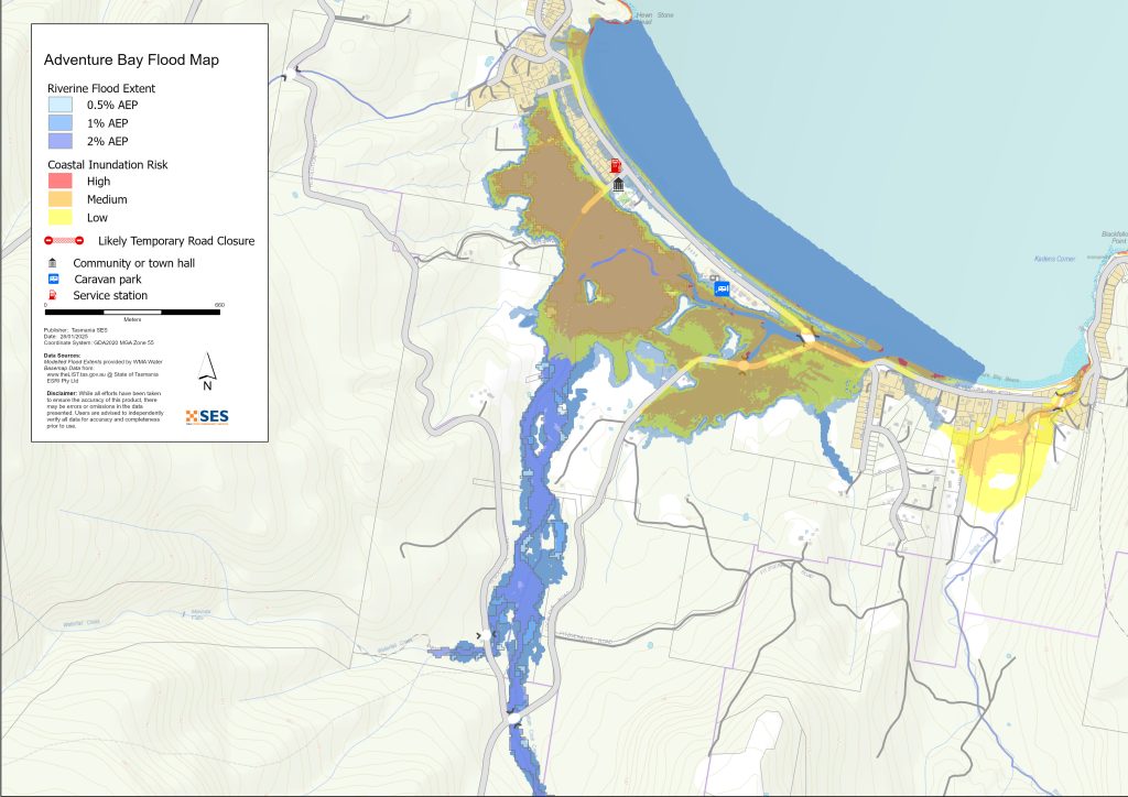
- แอดเวนเจอร์เบย์ – ใกล้กับกัปตันคุกส์ครีก.
ในทั้งสองกรณี น้ำท่วมมีโอกาสเกิดขึ้นได้มากกว่าเมื่อมีพายุซัดฝั่งร่วมกับน้ำทะเลหนุนสูง.
แม่น้ำลำคลองทุกสายในพื้นที่นี้มีขนาดสั้น ทำให้เครื่องวัดระดับน้ำไม่สามารถเตือนภัยได้อย่างเพียงพอ น้ำป่าไหลหลากอาจส่งผลกระทบต่อ:
- ถนนบริเวณจุดตัดแม่น้ำที่อยู่ในที่ต่ำ รวมถึงช่องฮายเวย์ (Channel Highway) เป็นช่วงสั้นๆ ในบางจุด ฮวนฮายเวย์ (Huon Highway) ใกล้กับแซนด์ฟลาย (Sandfly) และถนนแซนด์ฟลาย (Sandfly Road)
- อสังหาริมทรัพย์ 6 แห่งในมาร์เกต ใกล้กับแม่น้ำมาร์เกตริวูเล็ต หรือแม่น้ำนอร์ทเวสต์เบย์ริวูเล็ต
- เพิงพักหลายหลังใกล้ปากแม่น้ำกัปตันคุกส์ครีก ที่อ่าวแอดเวนเจอร์ เกาะบรูนี.
ทรัพย์สินบางแห่งอาจถูกตัดขาดเป็นระยะเวลาสั้นๆ เนื่องจากน้ำท่วมขังบนถนน นอกจากนี้ เศษซากต่างๆ อาจถูกพัดมาขวางบนถนน ซึ่งอาจปิดกั้นเส้นทางเป็นเวลานานขึ้น.
มีพื้นที่ชายฝั่งทะเลบางแห่งที่อยู่ต่ำซึ่งมีความเสี่ยงต่อภาวะน้ำท่วมชายฝั่ง น้ำท่วมชายฝั่งมีแนวโน้มที่จะเกิดขึ้นมากกว่าในช่วงที่มีพายุและน้ำขึ้นสูง พื้นที่ที่มีความเสี่ยงมากที่สุด ได้แก่:
- พื้นที่ริมน้ำเดอะเอสพลานาด ดรูว์พอยนต์ มาร์เกต และบาร์เรตตา
- ชายฝั่งที่อบอุ่นและปลอดภัย
- โลเวอร์ สนั๊ก / โอลด์ สเตชัน โรด, คอนนิงแฮม
- ถนนบรูนีไอส์แลนด์เมน ใกล้เกรทเบย์และคอคอด
- อัดเวนเจอร์เบย์ ใกล้กับกัปตันคุกส์ครีก
- เดนเนสพอยต์ เนบราสก้าบีช และบางพื้นที่ของถนนสายหลักเกาะบรันดี ใกล้กับเกรทเบย์และคอคอด.
การกัดเซาะชายฝั่งยังสามารถส่งผลกระทบต่อบางพื้นที่ได้ ซึ่งมีแนวโน้มที่จะเกิดขึ้นมากกว่าในช่วงที่มีพายุหรือน้ำท่วม.
ดู แผนที่อุทกภัยเชิงกลยุทธ์แทสเมเนีย หากต้องการดูแผนที่น้ำท่วมโดยละเอียดเพิ่มเติม หากต้องการตรวจสอบว่าทรัพย์สินของคุณมีความเสี่ยงต่อน้ำท่วมชายฝั่งหรือการกัดเซาะหรือไม่ โปรดดูที่ alert.tas.gov.au/get-ready/risk-ready/. ขณะนี้ SES กำลังเพิ่มแผนที่น้ำท่วมจากแม่น้ำลงในระบบ TasALERT risk-ready.
แผนที่ในคู่มือนี้แสดงระดับน้ำท่วมจากแม่น้ำหรือน้ำท่วมชายฝั่งที่มีโอกาสเกิดขึ้นอย่างน้อย 1% ในทุกปี (ข้อมูลสภาพอากาศจนถึงปี 2016) คุณมีแนวโน้มที่จะประสบกับน้ำท่วมเช่นที่แสดงในแผนที่นี้ในช่วงชีวิตของคุณ ชาวแทสมาเนียจำเป็นต้องเตรียมตัวรับมือกับเหตุการณ์น้ำท่วมที่อาจไม่เกิดขึ้นบ่อยครั้ง รวมถึงน้ำท่วมระดับเล็กน้อยที่พวกเขาอาจเคยประสบมาแล้ว แม้บ้านของคุณจะไม่ถูกน้ำท่วม คุณก็ควรเตรียมตัวรับมือกับการถูกตัดขาดจากโลกภายนอก รวมถึงการขาดแคลนไฟฟ้าและระบบโทรคมนาคมที่อาจเกิดขึ้นได้ ทั้งนี้ขึ้นอยู่กับพื้นที่ที่ฝนตกและปริมาณฝนที่ตกหนัก ถนนสายอื่น ๆ อาจไม่สามารถสัญจรได้เช่นกัน การเดินทางในพื้นที่ดังกล่าวอาจยากลำบากหรือเป็นไปไม่ได้จนกว่าถนนจะได้รับการเคลียร์แล้ว หากคุณอยู่ปลอดภัยที่บ้านหรือที่อื่น ๆ โดยทั่วไปแล้วควรอยู่ที่เดิมจนกว่าน้ำท่วมจะลดลง เว้นแต่มีสถานการณ์ฉุกเฉิน หากจำเป็นต้องอพยพ คุณควรออกเดินทางแต่เนิ่น ๆ ก่อนที่ระดับน้ำท่วมจะสูงขึ้น.

ไปที่เว็บไซต์ tasalert.com หรือฟังวิทยุ ABC ท้องถิ่นคลื่น 936AM สำหรับคำเตือนและคำแนะนำ.
คุณมีความเสี่ยงต่อน้ำท่วมหรือไม่
นอกเหนือจากปากแม่น้ำ Snug และ Adventure Bay ใกล้กับ Captain Cook’s Creek แล้ว น้ำท่วมจากแม่น้ำไม่ใช่เรื่องที่น่ากังวลสำหรับพื้นที่ส่วนใหญ่รอบเดอะแชนแนล แต่ที่นี่มีประวัติศาสตร์ยาวนานเกี่ยวกับพายุรุนแรงที่นำฝนตกหนัก พายุรุนแรงที่ทำให้เกิดปัญหาน้ำฝนไหลหลากและน้ำท่วมเคยเกิดขึ้น เช่น ในปี 1872, 1881, 1954, 1954, 1960, 1973, 1983, 1995, 1996, 2004, 2005, 2010, 2011, 2015 และ 2018.
ฉันควรทำอย่างไร
- ตรวจสอบแผนที่เพื่อดูว่าบ้านหรือธุรกิจของคุณอาจเกิดน้ำท่วมหรือไม่.
- ประเมินบ้านหรือธุรกิจของคุณและเตรียมพร้อมเพื่อลดความเสียหายจากน้ำท่วมที่อาจเกิดขึ้น.
- ตรวจสอบว่าคุณสามารถเดินทางกลับบ้าน ที่ทำงาน หรือโรงเรียนได้อย่างปลอดภัยในช่วงน้ำท่วมหรือไม่.
- จัดทำแผนฉุกเฉินประจำบ้าน พิจารณาว่าคุณจำเป็นต้องอพยพก่อนเกิดน้ำท่วมหรือไม่ ดู เตรียมพร้อมรับมือเหตุฉุกเฉิน– คู่มือสำหรับบุคคลและครัวเรือนในการเตรียมพร้อมรับมือกับเหตุฉุกเฉิน.
- หากคุณเป็นผู้ผลิตขั้นปฐมภูมิ ชุดอุปกรณ์เตรียมความพร้อมรับมือน้ำท่วมสำหรับฟาร์ม ให้คำแนะนำเกี่ยวกับการเตรียมตัวรับมือกับอุทกภัยเพื่อช่วยปกป้องธุรกิจและสินค้าคงคลังของคุณ.
- หากคุณดำเนินธุรกิจหรือองค์กรอื่น ลองดูข้อมูลจากรัฐบาลแทสมาเนีย ธุรกิจที่พร้อมรับมือภาวะฉุกเฉิน เครื่องมือออนไลน์
- หากคุณอาจถูกกักตัวและคุณต้องเข้าถึงบริการ คุณอาจต้องอพยพออกไปก่อน.
- หากคุณกำลังตั้งแคมป์ในพื้นที่เสี่ยงต่อน้ำท่วม ควรติดตามข่าวสารอย่างใกล้ชิด และย้ายไปยังที่สูงทันทีหากคาดว่าจะมีน้ำท่วม.
น้ำท่วม เช่น ที่แสดงในแผนที่ หรืออาจจะหนักกว่านี้ จะเกิดขึ้นอีกครั้ง ไม่มีน้ำท่วมสองครั้งที่เหมือนกัน.
หากคุณอาศัยอยู่ในพื้นที่ลุ่มต่ำหรือใกล้ทางน้ำ บ้านของคุณอาจถูกน้ำท่วม แม้ว่าบ้านของคุณจะปลอดภัย คุณอาจต้องอ้อมไปรอบๆ บริเวณที่น้ำท่วม หรือทางเข้าบ้านของคุณอาจถูกตัดขาด ห้ามขับรถหรือเดินลุยเข้าไปในน้ำท่วมเด็ดขาด ถนนและสะพานอาจถูกพัดหายไปหรือไม่ปลอดภัย หลีกเลี่ยงการเดินทางในช่วงน้ำท่วม.
การรู้ว่าต้องทำอะไรสามารถช่วยชีวิตคุณและปกป้องทรัพย์สินของคุณได้ การมีแผนรับมือเหตุฉุกเฉินที่บ้านเป็นวิธีเตรียมพร้อมที่ดีที่สุดวิธีหนึ่ง กำหนดเหตุการณ์สภาพอากาศและปริมาณน้ำฝนที่จะกระตุ้นให้ลงมือปฏิบัติ.
กรมอุตุนิยมวิทยา พยากรณ์, การเตือน, และการสังเกตการณ์
สำนักงานอุตุนิยมวิทยาจะออกคำเตือนภัยน้ำท่วม คำเตือนสภาพอากาศรุนแรง และ/หรือคำเตือนพายุฝนฟ้าคะนองสำหรับฝนตกหนักซึ่งอาจนำไปสู่ภาวะน้ำท่วมฉับพลัน เมื่อใดก็ตามที่มีคาดการณ์ว่าจะมีฝนตกหนักในพื้นที่ ระยะเวลาระหว่างการออกคำเตือนกับการเกิดฝนตกหนักอาจแตกต่างกันตั้งแต่หนึ่งชั่วโมงไปจนถึง 24 ชั่วโมงหรือมากกว่านั้น.
ไม่มีคำเตือนระดับน้ำท่วมสำหรับแม่น้ำสายใดในพื้นที่ เนื่องจากลุ่มน้ำมีขนาดสั้น ข้อมูลจากมาตรวัดน้ำจึงไม่สามารถให้เวลาเตือนล่วงหน้าได้เพียงพอ.
ตรวจสอบ การสังเกตปริมาณน้ำฝน ที่ภูเขา Wellington / kunanyi, Margate, Dennes Point และเครื่องวัดปริมาณน้ำฝนอื่นๆ ในบริเวณใกล้เคียง เนื่องด้วยเวลาเตือนภัยที่สั้นมาก จึงเป็นการดีที่สุดที่จะดำเนินการตามคำเตือนเชิงคาดการณ์ของ BoM แทนที่จะรอการแจ้งเตือนน้ำท่วมใดๆ ระหว่างที่ฝนตก.
เดอะ เรดาร์ยอดเขาคูเนีย เป็นประโยชน์ที่จะทราบแบบเรียลไทม์ว่าฝนตกหนักอยู่ที่ไหน การประมาณปริมาณน้ำฝนจากเรดาร์ยังสามารถเติมเต็มช่องว่างในพื้นที่ที่ไม่มีสถานีวัดปริมาณน้ำฝนได้.
ทำความเข้าใจคำเตือนและข้อมูลสำคัญ
เฝ้าระวังสิ่งที่เกิดขึ้นรอบตัวคุณ ตรวจสอบพยากรณ์อากาศ การสังเกตการณ์ และคำเตือนเป็นประจำ.
 |
คำแนะนำ (สีเหลือง): มีเหตุการณ์เกิดขึ้น ยังไม่มีอันตรายใดๆ โปรดติดตามความคืบหน้า เผื่อสถานการณ์เปลี่ยนแปลง. |
 |
ดูและดำเนินการ (สีส้ม): ระดับภัยคุกคามสูงขึ้น สภาพการณ์กำลังเปลี่ยนแปลงและคุณต้องเริ่มดำเนินการทันทีเพื่อปกป้องตัวเองและครอบครัว |
 |
คำเตือนฉุกเฉิน (สีแดง): คำเตือนฉุกเฉินคือระดับการเตือนภัยสูงสุด คุณอาจตกอยู่ในอันตรายและต้องดำเนินการทันที ความล่าช้าใดๆ ในตอนนี้จะทำให้ชีวิตของคุณตกอยู่ในความเสี่ยง. |
 |
อัปเดตชุมชน (สีน้ำเงิน): ข้อมูลและการอัปเดตเฉพาะสำหรับชุมชนที่ได้รับผลกระทบเกี่ยวกับเหตุการณ์หรืออุบัติการณ์เฉพาะ. |
 |
เหตุการณ์ (สีขาว): เหตุการณ์คือการเกิดขึ้นครั้งแรกของเหตุการณ์ก่อนที่จะกลายเป็นสัญญาณเตือนภัยฉุกเฉิน ทันทีที่ได้รับรายงานเหตุการณ์ TasALERT จะเผยแพร่ข้อมูลพื้นฐานรวมถึงประเภทและสถานที่เกิดเหตุ. |
ระดับน้ำท่วม
แม้ว่าน้ำท่วมแต่ละครั้งจะไม่เหมือนกัน แต่ข้อความต่อไปนี้จะอธิบายสิ่งที่คุณคาดว่าจะเกิดขึ้นได้ตามระดับน้ำท่วมต่างๆ รอบพื้นที่ แม้ว่าทรัพย์สินของคุณจะไม่ถูกน้ำท่วม แต่คุณจำเป็นต้องคำนึงถึงเรื่องเส้นทางเข้าออก ระดับปริมาณน้ำฝนที่แตกต่างกันอาจทำให้เกิดน้ำท่วมได้ ขึ้นอยู่กับความรุนแรง ระยะเวลา และความชุ่มชื้นของดินก่อนหน้านั้น รวมถึงบริเวณที่ฝนตก น้ำท่วมมีแนวโน้มที่จะเกิดขึ้นมากขึ้นในช่วงน้ำขึ้น สูงบริเวณชายฝั่ง ระบบสภาพอากาศที่ทำให้เกิดฝนตกหนักยังสามารถ ก่อให้เกิดคลื่นพายุซัดฝั่ง น้ำท่วมชายฝั่ง และการกัดเซาะชายฝั่งได้อีกด้วย.
น้ำท่วมเล็กน้อย
น้ำท่วมเล็กน้อยอาจส่งผลกระทบต่อ
- การข้ามลำน้ำบนถนนขนาดเล็กบางแห่ง
- พื้นที่เกษตรกรรมบนที่ราบลุ่มแม่น้ำ
- พื้นที่สวนสาธารณะริมแม่น้ำ พื้นที่สวนสาธารณะชายฝั่งอาจได้รับผลกระทบเช่นกันในช่วงน้ำขึ้นสูง.
- ระดับน้ำท่วมนี้มีโอกาสเกิดขึ้นประมาณ 10% หรือมากกว่านั้นในทุกปี.
น้ำท่วมปานกลาง
เหตุการณ์น้ำท่วมระดับปานกลางสามารถเอ่อล้นเข้าท่วมพื้นที่สวนสาธารณะริมแม่น้ำ รวมถึงสนามหลังบ้านและถนนในพื้นที่ลุ่มต่ำ บ้านเรือนบางหลังและสิ่งก่อสร้างอื่นๆ อาจเริ่มได้รับผลกระทบ โดยเฉพาะอย่างยิ่ง
- บรู๊คฟิลด์ใกล้กับมาร์เก็ตและอสังหาริมทรัพย์สองสามแห่งตามลำธารมาร์เก็ตริวูเล็ต
- พื้นที่ลุ่มต่ำใกล้ปากแม่น้ำสนักรีเวอร์
- พื้นที่ลุ่มต่ำอื่นๆ ใกล้ชายฝั่งและทางน้ำ
ระดับน้ำท่วมนี้มีโอกาสเกิดขึ้นประมาณ 2-5% ในแต่ละปี.
ระบบน้ำฝน น้ำประปา และระบบสุขาภิบาลอาจได้รับผลกระทบ.
น้ำท่วมใหญ่
น้ำท่วมรุนแรงที่มีโอกาสเกิดขึ้น 1% อาจส่งผลกระทบต่อ:
- อสังหาริมทรัพย์จำนวนมากบริเวณปากแม่น้ำสนักรีเวอร์
- อสังหาริมทรัพย์บางแห่งใกล้กับกัปตันคุกส์ครีก แอดเวนเจอร์เบย์ เกาะบรูนี
- อสังหาริมทรัพย์บางแห่งตามลำห้วย North West Bay Rivulet และ Margate Rivulet
- อาจหมายถึงบางพื้นที่ของแชนแนลไฮเวย์และถนนสายหลักเกาะบรันดีอาจถูกตัดขาดเป็นเวลาสั้นๆ บางพื้นที่อาจถูกตัดขาดจากภายนอก.
- ในช่วงน้ำขึ้นสูง อาจมีพื้นที่เพิ่มเติมบางแห่งที่มีความเสี่ยงต่อน้ำท่วมชายฝั่งเช่นกัน เช่น:
- มาร์เก็ต ดรู พอยต์/ เอสพละนาด และ บาร์เร็ตตา
- ชายฝั่งที่เว้าเข้าอย่างอบงดงาม รวมถึงพื้นที่รอบสนามโอวัลไปจนถึงสวนคาราวาน
- โลเวอร์ สนัก/คอนนิงแฮม ใกล้กับสนัก ครีก และโอลด์ สเตชัน โรด
- พื้นที่ท่าเรือสำราญเคตเทอริง/ถนนเฟอร์รี่
- หาดวูดบริดจ์
- บนเกาะบรันนี, เดนเนสพอยต์, พื้นที่ต่างๆ ตามแนวหาดเนบราสก้า
- แอดเวนเจอร์เบย์ โดยเฉพาะบริเวณลำธารกัปตันคุกส์ริวูเล็ต
- บางช่วงของถนนบรุนีไอส์แลนด์เมนโรด (Bruny Island Main Road) ใกล้กับเกรทเบย์ (Great Bay) อิสท์มัส (the Isthmus) และอะลอนนาห์ (Alonnah).


ไปที่ TasALERT.com หรือฟังวิทยุ ABC ท้องถิ่นสำหรับข้อมูลและคำแนะนำที่ละเอียดและเป็นปัจจุบันในช่วงที่มีฝนตกหนัก.
รู้ความเสี่ยงของคุณ เตรียมพร้อม ลดความเสี่ยงเท่าที่ทำได้ เชื่อมต่อกับผู้อื่น ตื่นตัวเสมอ และดำเนินการอย่างปลอดภัย.
ก่อนน้ำท่วม
เตรียมพร้อมรับมือเหตุฉุกเฉิน – คู่มือสำหรับบุคคลและครัวเรือนในการเตรียมพร้อมรับมือกับเหตุฉุกเฉิน.
1. รู้จักความเสี่ยงของคุณ
น้ำท่วมมักเกิดขึ้นในแทสเมเนียและอาจก่อให้เกิดความเสียหายในวงกว้างและรุนแรง ในช่วง 200 ปีที่ผ่านมา มีผู้เสียชีวิตจากเหตุน้ำท่วมในแทสเมเนีย 78 ราย คู่มือนี้จัดทำขึ้นเพื่อช่วยให้คุณเข้าใจเกี่ยวกับความเสี่ยงจากน้ำท่วมในพื้นที่ของคุณ.
2. เตรียมบ้านของคุณ
เตรียมแผนฉุกเฉินที่ครอบคลุมพายุและน้ำท่วม
การคิดถึงสิ่งที่คุณจะทำในระหว่างพายุหรือน้ำท่วม หมายถึงคุณมีความพร้อมมากขึ้น และทุกคนจะปลอดภัยยิ่งขึ้น จัดทำแผนฉุกเฉินที่ทุกคนในครัวเรือนของคุณเข้าใจ มีรายการตรวจสอบเพื่อช่วยให้คุณคิดถึงแผนของคุณ – ดู เตรียมพร้อมรับมือเหตุฉุกเฉิน – คู่มือสำหรับบุคคลและครัวเรือนในการเตรียมพร้อมรับมือกับเหตุฉุกเฉิน.
ตรวจสอบแผนของคุณอย่างสม่ำเสมอ และทดสอบโดยสมาชิกทุกคนในครอบครัวลองนึกถึงสถานการณ์น้ำท่วมที่อาจส่งผลกระทบต่อครอบครัวของคุณ.
เตรียมชุดอุปกรณ์ฉุกเฉิน
พร้อมไป
- วิทยุไฟฉายใช้แบตเตอรี่ พร้อมแบตเตอรี่สำรอง
- ข้อมูลสำคัญ เช่น แผนฉุกเฉินของคุณ
- รายการเบอร์โทรศัพท์ฉุกเฉิน
- อาหารและน้ำ
- ชุดปฐมพยาบาล
- ถุงมือยาง หรือหนังที่แข็งแรง
จัดกระเป๋าเมื่อจำเป็น
- เสื้อผ้าที่อบอุ่น รองเท้าที่ทนทาน หรือรองเท้าบูท
- ยา แว่นตา หรือสิ่งของจำเป็นอื่นๆ
- โทรศัพท์มือถือและที่ชาร์จโทรศัพท์
- อาหารสัตว์เลี้ยงและสิ่งอื่น ๆ ที่พวกเขาต้องการ
- รูปถ่ายและของที่ระลึกพิเศษ
- เงิน
- เอกสารสำคัญ ตัวอย่างเช่น
-
- เอกสารประกัน
-
- หนังสือเดินทางและ
-
- สูติบัตร
ทดสอบแบตเตอรี่วิทยุและไฟฉายเป็นประจำ.
3. ลดความเสี่ยงจากน้ำท่วมในบริเวณที่คุณสามารถทำได้
- คำนึงถึงพายุ น้ำท่วม และอันตรายอื่นๆ เมื่อซื้อ บำรุงรักษา หรือพัฒนาอสังหาริมทรัพย์.
- ตัดแต่งหรือโค่นต้นไม้และกิ่งก้านที่ยื่นเข้ามาเหนือบ้าน ธุรกิจ หรือใกล้สายไฟฟ้าบนทรัพย์สินของคุณ.
- รักษารางน้ำและท่อระบายน้ำของคุณให้โล่ง.
4. ติดต่อกับผู้อื่น
ทำความรู้จักเพื่อนบ้านและมีส่วนร่วมในชุมชนของคุณ ชุมชนที่มีความเชื่อมโยงกันคือชุมชนที่ปลอดภัยและมีความยืดหยุ่นมากกว่าในยามฉุกเฉิน และสามารถช่วยให้ทุกคนฟื้นตัวได้ดีขึ้นหลังจากนั้น ตรวจสอบให้แน่ใจว่าครอบครัวและเพื่อนบ้านปลอดภัยและรับทราบถึงสิ่งที่เกิดขึ้น.
ระหว่าง
5. ติดตามข้อมูลให้เป็นปัจจุบันอยู่เสมอ
เฝ้าระวังสิ่งที่เกิดขึ้นรอบตัวคุณ ตรวจสอบพยากรณ์อากาศ การสังเกตการณ์ และคำเตือนเป็นประจำ.
- เดอะ กรมอุตุนิยมวิทยา เว็บไซต์.
6. ปฏิบัติตัวอย่างปลอดภัย
- ดูแลเด็ก.
- เตรียมพร้อมรับมือการหยุดชะงักที่เป็นไปได้ของไฟฟ้า น้ำ หรืออินเทอร์เน็ต.
- ตรวจสอบชุดฉุกเฉินของคุณให้พร้อมใช้งาน.
- หลีกเลี่ยงพื้นที่ที่ถูกน้ำท่วม เช่น ท่อระบายน้ำ. ไม่ เดิน เล่น ขี่ หรือขับรถในน้ำท่วม คุณไม่สามารถมองเห็นสิ่งที่อยู่ใต้น้ำเสมอไป หรือน้ำมีความลึกหรือไหลเร็วเท่าใด ก็ตามเป็นเรื่องง่ายที่จะถูกพัดพาไปและจมน้ำในน้ำที่ไหลเร็วเพียง 20 ซม. น้ำท่วมอาจเป็นอันตรายได้.
เมื่อบ้านของคุณอาจถูกน้ำท่วม
- เก็บของใช้ในครัวเรือนไว้ในที่สูงเพื่อลดความเสียหายที่อาจเกิดขึ้น.
- ปิดไฟฟ้าและแก๊สหากสามารถทำได้อย่างปลอดภัย.
- วิธีที่ดีในการหยุดน้ำเสียไหลย้อนกลับเข้าบ้านของคุณคือการนำกระสอบทรายใส่ในถุงพลาสติก แล้วใช้กระสอบทรายเหล่านั้นอุดโถส้วมและปิดท่อระบายน้ำและอ่างล้างจาน.
- รีบออกไปก่อนที่คุณจะสามารถออกไปได้อย่างปลอดภัย.
หากคุณจำเป็นต้องอพยพ
- ปฏิบัติตามคำแนะนำจาก SES / ตำรวจแทสเมเนีย.
- นำชุดฉุกเฉินของคุณไปด้วย.
- ไปหาเพื่อนหรือญาติในที่ปลอดภัยกว่า หรือศูนย์พักพิง.
- บอกให้คนอื่นรู้ว่าคุณไปที่ไหน.
ดูแลสัตว์เลี้ยงของคุณ
คุณมีหน้าที่รับผิดชอบสัตว์เลี้ยงของคุณในยามฉุกเฉิน หากคุณมีสัตว์เลี้ยงและสัตว์อื่นๆ จะทำให้คุณต้องใช้เวลาอพยพนานขึ้นในยามเกิดน้ำท่วมหรือเหตุฉุกเฉินอื่นๆ ให้ย้ายปศุสัตว์ออกจากพื้นที่เสี่ยงต่อน้ำท่วมก่อนที่ระดับน้ำจะสูงขึ้น สำหรับข้อมูลเพิ่มเติม โปรดดู
หลีกเลี่ยงการเดินทางในช่วงที่มีพายุและหลังพายุ
- อย่าไปชมทิวทัศน์ จุดสนใจของนักท่องเที่ยวทำให้บริการฉุกเฉินล่าช้าและก่อให้เกิดอุบัติเหตุ.
- ระวังอันตรายต่างๆ เช่น
-
- น้ำท่วมถนน
-
- สายไฟฟ้าที่เสียหาย
-
- ดินถล่ม
-
- ถนนชำรุด
-
- ต้นไม้ล้มหรือหลังคาเหล็ก.
- ห้ามขับรถฝ่ากระแสน้ำท่วมโดยเด็ดขาด เหตุการณ์เสียชีวิตและต้องได้รับการช่วยเหลือจากน้ำท่วมส่วนใหญ่เกิดจากผู้ขับขี่พยายามขับรถฝ่ากระแสน้ำท่วม.
- ขับรถช้าๆ และเปิดไฟหน้ารถบนถนนที่ไม่อยู่ในบริเวณน้ำท่วม.
หลังจาก
- โปรดคอยรับฟังข่าวสารล่าสุดของ ABC Local Radio การเปิดถนนอีกครั้ง การประชุมชุมชน และอื่นๆ.
- หากท่านออกจากบ้านแล้ว ห้ามกลับเข้าบ้านจนกว่า SES หรือตำรวจแทสเมเนียจะแจ้งว่าปลอดภัย.
- ระมัดระวังอันตรายบนท้องถนน เช่น โคลนหรือเศษขยะบนถนน ถนน/สะพานที่ชำรุด และเจ้าหน้าที่ที่กำลังทำงานทำความสะอาดและซ่อมแซม.
หากบ้านของคุณได้รับความเสียหาย
- อยู่ในระดับพื้นดินขณะตรวจสอบความเสียหาย ระวังต้นไม้ที่โค่นล้ม กระจกแตก หลังคาหลุดลุ่ย หรืออันตรายอื่นๆ.
- สวมรองเท้าบูท ถุงมือ และเสื้อผ้าป้องกันที่แข็งแรง.
- ใช้ไฟฉาย ห้ามใช้ไม้ขีดไฟหรือเทียนไขภายในอาคารที่ถูกน้ำท่วม.
- ต้มน้ำดื่มทุกครั้งจนกว่าจะได้รับแจ้งว่าน้ำประปาปลอดภัยอีกครั้ง.
- ห้ามเปิดใช้งานจนกว่าจะได้รับการตรวจสอบความปลอดภัยโดยช่างไฟฟ้าหรือช่างแก๊สที่ได้รับใบอนุญาต.
- หากบ้านของคุณได้รับความเสียหาย และคุณต้องไปพักที่อื่น ให้นำชุดอุปกรณ์ฉุกเฉินและสัตว์เลี้ยงของคุณไปด้วย
- ถ่ายรูปความเสียหายที่พบ หากทำได้อย่างปลอดภัย แล้วติดต่อบริษัทประกันภัยของคุณ.
- ดูแลเด็ก.
- ตรวจสอบเพื่อนบ้านว่าโอเคหรือเปล่า.
สำหรับข้อมูลเพิ่มเติม ไปที่ www.ses.tas.gov.au
การรับทราบข้อมูลและข้อมูลเพิ่มเติม
ประกาศเตือนภัยปัจจุบัน – TasALERT.com
ผู้กระจายสัญญาณเหตุฉุกเฉิน สถานีวิทยุ ABC ในพื้นที่ของคุณ
โซเชียลมีเดียของ TASSES – facebook.com/sestasmania
การเตรียมพร้อมรับมือสถานการณ์น้ำท่วมฉุกเฉิน ses.tas.gov.au/flood-plan/
บริการถ่ายทอดแห่งชาติ (NRS) relayservice.gov.au
เทศบาลคิงส์โบโรห์ www.kingborough.tas.gov.au 6211 8200
สถานีวิทยุกระจายเสียงฉุกเฉินท้องถิ่น เอบีซี 936 เอเอ็ม

ข้อจำกัดความรับผิด
The maps show potential flooding risks from consistent levels of rainfall across catchments, such as a 1% Annual Exceedance Probability (AEP). In flooding events, rainfall is likely to be more inconsistent across a catchment, so these flood maps should be considered indicative only. The mapped areas of flood risk show higher probability of inundation. Other areas have lower probability of flooding, but in severe and rare events (rarer than 1%AEP), other lower areas may be also at risk of inundation.
ข้อมูลในคู่มือนี้เป็นข้อมูล ณ วันที่เผยแพร่ แม้ว่าจะได้ใช้ความพยายามอย่างเต็มที่เพื่อให้แน่ใจว่าข้อมูลที่นำเสนอมีความถูกต้องและเชื่อถือได้ แต่หน่วยบริการภาวะฉุกเฉินของรัฐจะไม่รับผิดชอบต่อข้อผิดพลาดหรือการละเว้นของข้อมูล โปรดดูมาตรฐาน ข้อความสงวนลิขสิทธิ์และข้อจำกัดความรับผิดชอบของรัฐบาลแทสเมเนีย สำหรับรายละเอียดเพิ่มเติม.