คู่มือการรับมือกับน้ำท่วมในลุ่มน้ำรูบิคอน
Flooding information for communities from Elizabeth Town to Port Sorell and surrounds
Version 1.1 January 2026 – PDF version
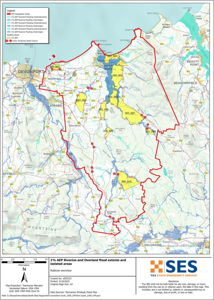
เพื่อดูแผนที่ในรายละเอียดมากขึ้น, ดูแผนที่น้ำท่วมเชิงยุทธศาสตร์ของแทสเมเนีย.
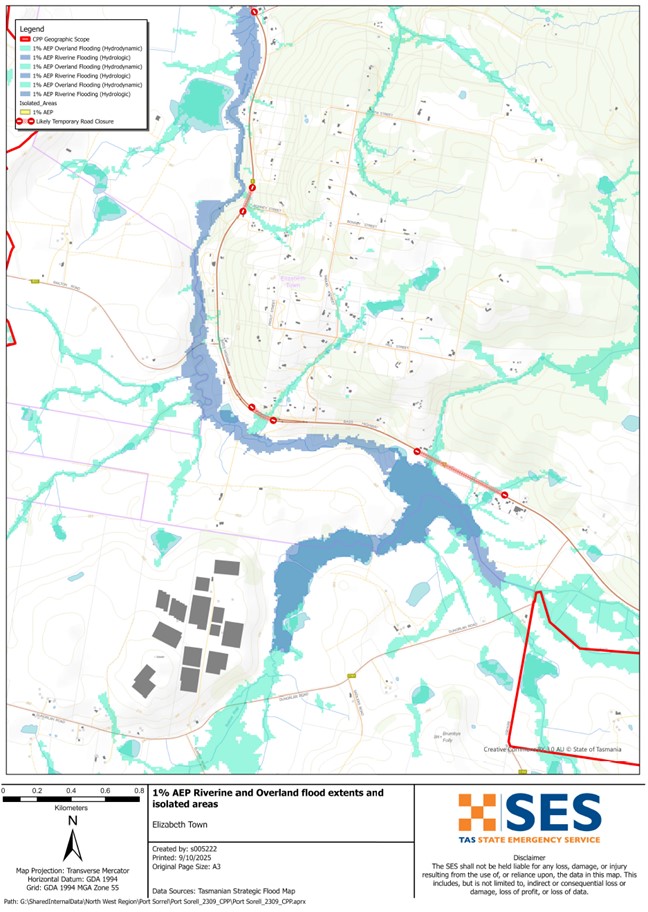
If the Rubicon River has a major flood, low lying areas near the river can flood. Floodwater can cut roads such as
- Bass Highway near Elizabeth Town
- Port Sorell Road, and
- Local streets like Rice Street and Seabreeze Avenue in several places.
If there is heavy local rain, other areas can also have flash flooding from local waterways such as
- Panatana Rivulet
- Pardoe Creek, and
- Franklin Rivulet.
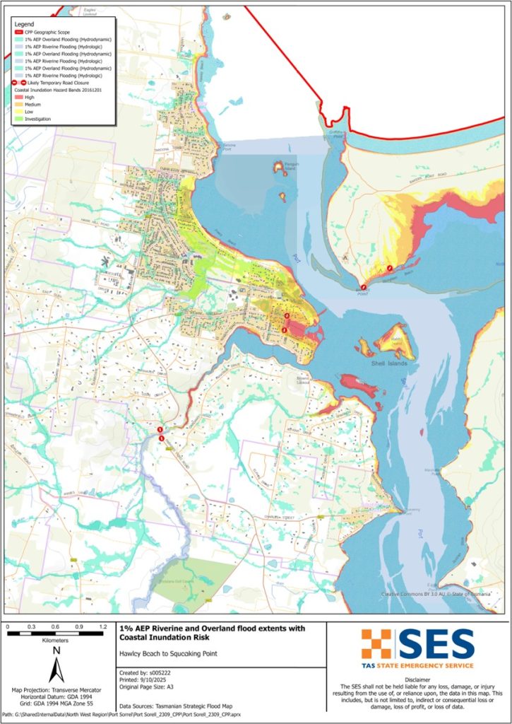
In a flash flood, you cannot rely on flood warnings from rivers, only forecasts for heavy rain or severe weather. Higher than usual tides and storms may also increase the risk of flooding in lower lying areas surrounding the Port Sorell waterway.
The maps in this guide show the level of flooding that has a 1% chance of happening any year. You are likely to experience flooding such as that shown in the maps in your lifetime. Tasmanians need to prepare for flood events that may not happen often, as well as the minor flooding they may have experienced.
Even if your home is not inundated, you should be prepared for isolation plus potential power and telecommunications outages. Depending on where the rain falls and how heavy it is, roads throughout the area may be impassable. Travel in the area is likely to be difficult or impossible until the roads are clear. If you are safe at home or elsewhere, it is usually best you stay where you are until the flooding subsides, unless there is an emergency. If you need to evacuate, you should leave early, before flood water rises.
Listen to ABC local radio 91.7FM for warnings and advice.
คุณมีความเสี่ยงต่อน้ำท่วมหรือไม่
The Rubicon River has a history of flooding with flooding impacts seen as recently as 2022.
ฉันควรทำอย่างไร
- ตรวจสอบแผนที่เพื่อดูว่าบ้านหรือธุรกิจของคุณอาจเกิดน้ำท่วมหรือไม่.
- ประเมินบ้านหรือธุรกิจของคุณและเตรียมพร้อมเพื่อลดความเสียหายจากน้ำท่วมที่อาจเกิดขึ้น.
- ตรวจสอบว่าคุณสามารถเดินทางกลับบ้าน ที่ทำงาน หรือโรงเรียนได้อย่างปลอดภัยในช่วงน้ำท่วมหรือไม่.
- จัดทำแผนฉุกเฉินประจำบ้าน พิจารณาว่าคุณจำเป็นต้องอพยพก่อนเกิดน้ำท่วมหรือไม่ ดู เตรียมพร้อมรับมือเหตุฉุกเฉิน– คู่มือสำหรับบุคคลและครัวเรือนในการเตรียมพร้อมรับมือกับเหตุฉุกเฉิน.
- If you are a primary producer, the Farm Flood Readiness Kit provides advice on preparing for a flood to help protect your business and stock.
- If you run a business or other organisation, check out the Tasmanian Government’s Emergency Ready Business tool online
- หากคุณอาจถูกกักตัวและคุณต้องเข้าถึงบริการ คุณอาจต้องอพยพออกไปก่อน.
- หากคุณกำลังตั้งแคมป์ในพื้นที่เสี่ยงต่อน้ำท่วม ควรติดตามข่าวสารอย่างใกล้ชิด และย้ายไปยังที่สูงทันทีหากคาดว่าจะมีน้ำท่วม.
น้ำท่วม เช่น ที่แสดงในแผนที่ หรืออาจจะหนักกว่านี้ จะเกิดขึ้นอีกครั้ง ไม่มีน้ำท่วมสองครั้งที่เหมือนกัน.
หากคุณอาศัยอยู่ในพื้นที่ลุ่มต่ำหรือใกล้ทางน้ำ บ้านของคุณอาจถูกน้ำท่วม แม้ว่าบ้านของคุณจะปลอดภัย คุณอาจต้องอ้อมไปรอบๆ บริเวณที่น้ำท่วม หรือทางเข้าบ้านของคุณอาจถูกตัดขาด ห้ามขับรถหรือเดินลุยเข้าไปในน้ำท่วมเด็ดขาด ถนนและสะพานอาจถูกพัดหายไปหรือไม่ปลอดภัย หลีกเลี่ยงการเดินทางในช่วงน้ำท่วม.
การรู้ว่าต้องทำอะไรสามารถช่วยชีวิตคุณและปกป้องทรัพย์สินของคุณได้ การมีแผนรับมือเหตุฉุกเฉินที่บ้านเป็นวิธีเตรียมพร้อมที่ดีที่สุดวิธีหนึ่ง กำหนดเหตุการณ์สภาพอากาศและปริมาณน้ำฝนที่จะกระตุ้นให้ลงมือปฏิบัติ.
กรมอุตุนิยมวิทยา พยากรณ์, การเตือน, และการสังเกตการณ์
สำนักออก ประกาศเตือนภัยน้ำท่วม, ประกาศเตือนสภาพอากาศรุนแรง และ/หรือ ประกาศเตือนพายุฝนฟ้าคะนองสำหรับฝนตกหนักที่อาจทำให้เกิดน้ำท่วมฉับพลัน เมื่อไรก็ตาม ฝนตกหนัก คาดว่าจะเกิดขึ้นในพื้นที่ ระยะเวลาระหว่างการเตือนภัยกับฝนตกหนักอาจแตกต่างกันไปตั้งแต่หนึ่งชั่วโมงถึง 24 ชั่วโมงขึ้นไป.
Whenever rain that may lead to flooding along the Rubicon River is expected, the Bureau may issue a Flood Watch – a “heads up” early advice of forecast weather that may lead to flooding.
SES and the Bureau are unlikely to be able to issue specific local warnings when flooding impacts are observed in this area. There are no formal warning levels for other waterways in the area.
การสังเกตปริมาณน้ำฝน at Deloraine Railway Bridge, Kimberley and Devonport Airport and other nearby rain gauges can indicate possible flood risks. Given the very short warning times, it is best to act on the predictive BoM warnings rather than wait for any flood alerts during rainfall.
Rainfall may start impacting the area at the following thresholds:
-
- 90-145mm rainfall over 12-24 hours
-
- 160-230mm rainfall over 48-72hrs
Abnormally high tides may also cause flooding in low-lying coastal areas around the Port Sorell waterway near the mouth of the Rubicon River.
เดอะ West Takone is useful to be aware in real-time where heavy rainfall is falling. Radar rainfall estimates can also fill in gaps in areas where there are no rainfall stations.
ทำความเข้าใจคำเตือนและข้อมูลสำคัญ
เฝ้าระวังสิ่งที่เกิดขึ้นรอบตัวคุณ ตรวจสอบพยากรณ์อากาศ การสังเกตการณ์ และคำเตือนเป็นประจำ.
 |
คำแนะนำ (สีเหลือง): มีเหตุการณ์เกิดขึ้น ยังไม่มีอันตรายใดๆ โปรดติดตามความคืบหน้า เผื่อสถานการณ์เปลี่ยนแปลง. |
 |
ดูและดำเนินการ (สีส้ม): ระดับภัยคุกคามสูงขึ้น สภาพการณ์กำลังเปลี่ยนแปลงและคุณต้องเริ่มดำเนินการทันทีเพื่อปกป้องตัวเองและครอบครัว |
 |
คำเตือนฉุกเฉิน (สีแดง): คำเตือนฉุกเฉินคือระดับการเตือนภัยสูงสุด คุณอาจตกอยู่ในอันตรายและต้องดำเนินการทันที ความล่าช้าใดๆ ในตอนนี้จะทำให้ชีวิตของคุณตกอยู่ในความเสี่ยง. |
 |
อัปเดตชุมชน (สีน้ำเงิน): ข้อมูลและการอัปเดตเฉพาะสำหรับชุมชนที่ได้รับผลกระทบเกี่ยวกับเหตุการณ์หรืออุบัติการณ์เฉพาะ. |
| เหตุการณ์ (สีขาว): เหตุการณ์คือการเกิดขึ้นครั้งแรกของเหตุการณ์ก่อนที่จะกลายเป็นสัญญาณเตือนภัยฉุกเฉิน ทันทีที่ได้รับรายงานเหตุการณ์ TasALERT จะเผยแพร่ข้อมูลพื้นฐานรวมถึงประเภทและสถานที่เกิดเหตุ. |
ระดับน้ำท่วม
แม้ว่าน้ำท่วมแต่ละครั้งจะไม่เหมือนกัน แต่ต่อไปนี้คือสิ่งที่คุณคาดหวังได้จากระดับน้ำท่วมที่แตกต่างกันในพื้นที่ แม้ว่าทรัพย์สินของคุณจะไม่ถูกน้ำท่วม แต่คุณก็ต้องคำนึงถึงการเข้าถึงด้วย ระดับน้ำฝนที่แตกต่างกันสามารถทำให้น้ำท่วมได้ ขึ้นอยู่กับความรุนแรง ระยะเวลา และพื้นดินมีความชื้นมากน้อยเพียงใดก่อนหน้านี้ และปริมาณน้ำฝนที่ตก.
Minor to Moderate Flooding
น้ำท่วมเล็กน้อย
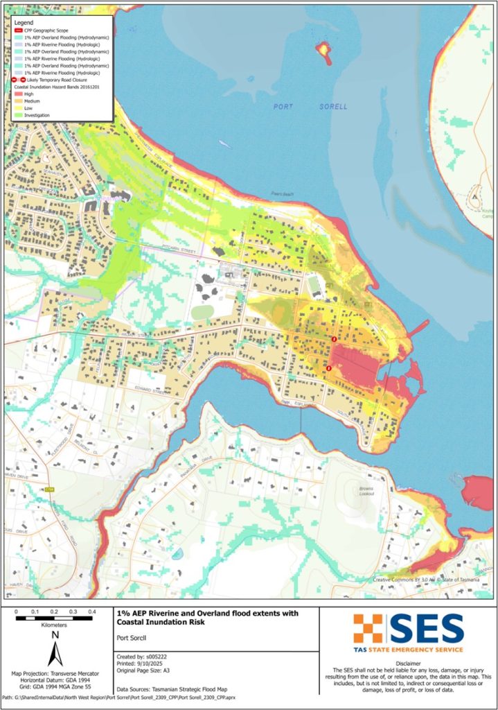
A minor flood can inundate low lying paddocks, orchards and other farmland. Stock should be moved for their safety. There may also be some flooding across some minor roads and parkland areas. Areas close to the shoreline may see some higher levels of flooding during higher tides.
น้ำท่วมปานกลาง
There is more extensive flooding of agricultural land and some buildings may be impacted to above floor height. Some properties may be isolated for a few hours as minor roads become flooded. For example, some properties may see flooding at:
-
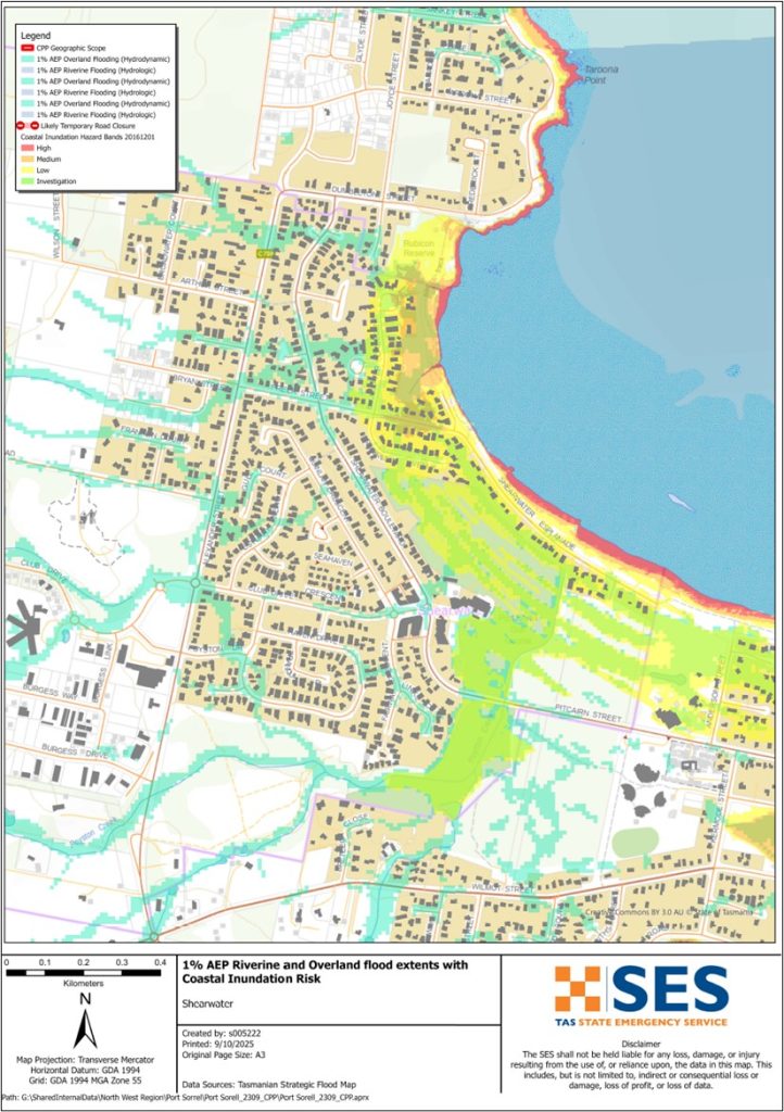
- Port Sorell:
-
- Highwater Lane, Seahorse Lane and Rice Street.
-
- The Port Sorell Caravan park may begin to flood
-
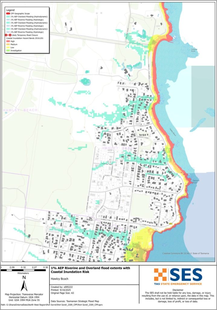
- Hawley Beach:
-
- Sankey St
-
- Hawley St.
น้ำท่วมใหญ่
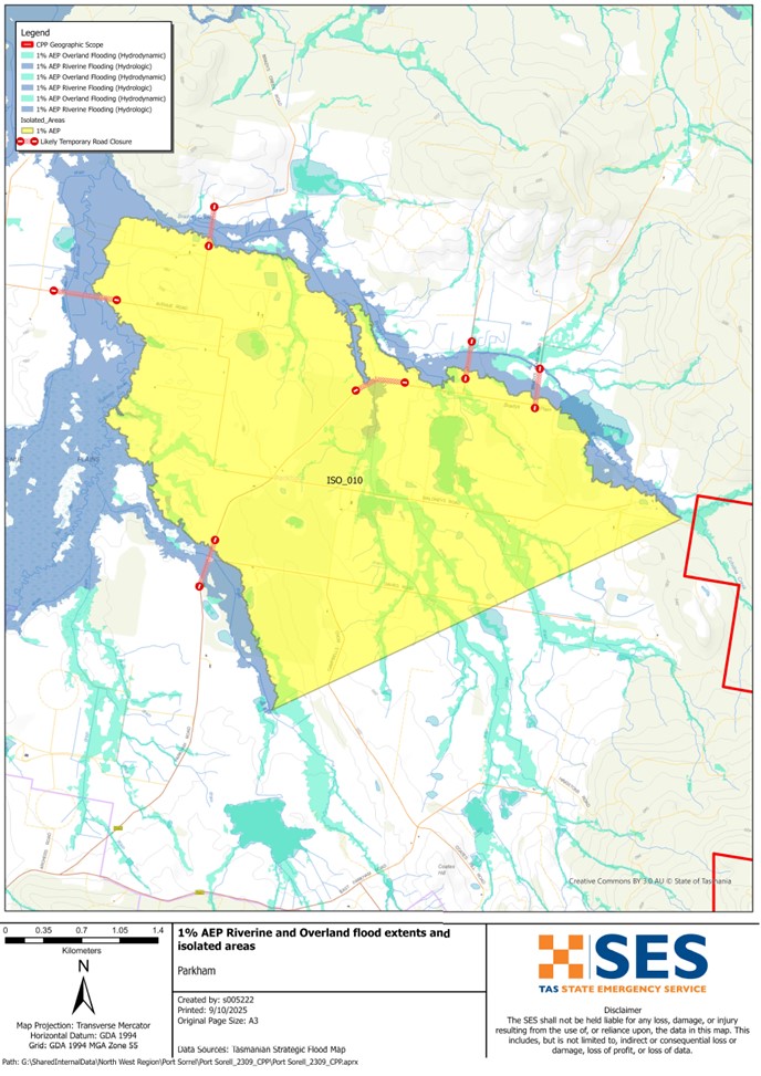
If there is major flooding along the Rubicon River and other waterways, there may be flooding in low-lying areas close to the river. That level of flooding is approximately the level of the 2011, 2016 and 2022 floods and there is about a 5% chance of such a flood happening any year. Tasmanians need to be prepared for floods that have a 1% chance of happening every year.
Depending on where the rain falls and the level of soil saturation, this level of flooding is likely to:
-
- Flood some properties in low lying areas near the Rubican River, such as areas of Port Sorell and Shearwater.
-
- Close several roads in the area, including the Bass Highway, Port Sorell Road and other local roads isolating surrounding properties
-
- Isolate several parts of the community including parts of the Bakers Beach area, Narawntapu National Park, Harford and Frankford
-
- Flooding can impact Devonport Airport operations.
Go to TasALERT.com or listen to ABC local radio for detailed up to date information and advice during heavy rainfall events.
รู้ความเสี่ยงของคุณ เตรียมพร้อม ลดความเสี่ยงเท่าที่ทำได้ เชื่อมต่อกับผู้อื่น ตื่นตัวเสมอ และดำเนินการอย่างปลอดภัย.
ก่อนน้ำท่วม
เตรียมพร้อมรับมือเหตุฉุกเฉิน – คู่มือสำหรับบุคคลและครัวเรือนในการเตรียมพร้อมรับมือกับเหตุฉุกเฉิน.
1. รู้จักความเสี่ยงของคุณ
น้ำท่วมมักเกิดขึ้นในแทสเมเนียและอาจก่อให้เกิดความเสียหายในวงกว้างและรุนแรง ในช่วง 200 ปีที่ผ่านมา มีผู้เสียชีวิตจากเหตุน้ำท่วมในแทสเมเนีย 78 ราย คู่มือนี้จัดทำขึ้นเพื่อช่วยให้คุณเข้าใจเกี่ยวกับความเสี่ยงจากน้ำท่วมในพื้นที่ของคุณ.
2. เตรียมบ้านของคุณ
เตรียมแผนฉุกเฉินที่ครอบคลุมพายุและน้ำท่วม
การคิดถึงสิ่งที่คุณจะทำในระหว่างพายุหรือน้ำท่วม หมายถึงคุณมีความพร้อมมากขึ้น และทุกคนจะปลอดภัยยิ่งขึ้น จัดทำแผนฉุกเฉินที่ทุกคนในครัวเรือนของคุณเข้าใจ มีรายการตรวจสอบเพื่อช่วยให้คุณคิดถึงแผนของคุณ – ดู เตรียมพร้อมรับมือเหตุฉุกเฉิน – คู่มือสำหรับบุคคลและครัวเรือนในการเตรียมพร้อมรับมือกับเหตุฉุกเฉิน.
ตรวจสอบแผนของคุณอย่างสม่ำเสมอ และทดสอบโดยสมาชิกทุกคนในครอบครัวลองนึกถึงสถานการณ์น้ำท่วมที่อาจส่งผลกระทบต่อครอบครัวของคุณ.
เตรียมชุดอุปกรณ์ฉุกเฉิน
พร้อมไป
- วิทยุไฟฉายใช้แบตเตอรี่ พร้อมแบตเตอรี่สำรอง
- ข้อมูลสำคัญ เช่น แผนฉุกเฉินของคุณ
- รายการเบอร์โทรศัพท์ฉุกเฉิน
- อาหารและน้ำ
- ชุดปฐมพยาบาล
- ถุงมือยาง หรือหนังที่แข็งแรง
จัดกระเป๋าเมื่อจำเป็น
- เสื้อผ้าที่อบอุ่น รองเท้าที่ทนทาน หรือรองเท้าบูท
- ยา แว่นตา หรือสิ่งของจำเป็นอื่นๆ
- โทรศัพท์มือถือและที่ชาร์จโทรศัพท์
- อาหารสัตว์เลี้ยงและสิ่งอื่น ๆ ที่พวกเขาต้องการ
- รูปถ่ายและของที่ระลึกพิเศษ
- เงิน
- เอกสารสำคัญ ตัวอย่างเช่น
-
- เอกสารประกัน
-
- หนังสือเดินทางและ
-
- สูติบัตร
ทดสอบแบตเตอรี่วิทยุและไฟฉายเป็นประจำ.
3. ลดความเสี่ยงจากน้ำท่วมในบริเวณที่คุณสามารถทำได้
- คำนึงถึงพายุ น้ำท่วม และอันตรายอื่นๆ เมื่อซื้อ บำรุงรักษา หรือพัฒนาอสังหาริมทรัพย์.
- ตัดแต่งหรือโค่นต้นไม้และกิ่งก้านที่ยื่นเข้ามาเหนือบ้าน ธุรกิจ หรือใกล้สายไฟฟ้าบนทรัพย์สินของคุณ.
- รักษารางน้ำและท่อระบายน้ำของคุณให้โล่ง.
4. ติดต่อกับผู้อื่น
Know your neighbours and get involved in your community. A connected community is a safer and more resilient community in an emergency and can help everyone recover better afterwards. Check that family and neighbours are safe and aware of what’s happening.
ระหว่าง
5. Keep up to date
เฝ้าระวังสิ่งที่เกิดขึ้นรอบตัวคุณ ตรวจสอบพยากรณ์อากาศ การสังเกตการณ์ และคำเตือนเป็นประจำ.
- เดอะ กรมอุตุนิยมวิทยา เว็บไซต์.
6. Act Safe
- ดูแลเด็ก.
- เตรียมพร้อมรับมือการหยุดชะงักที่เป็นไปได้ของไฟฟ้า น้ำ หรืออินเทอร์เน็ต.
- ตรวจสอบชุดฉุกเฉินของคุณให้พร้อมใช้งาน.
- หลีกเลี่ยงพื้นที่ที่ถูกน้ำท่วม เช่น ท่อระบายน้ำ. ไม่ เดิน เล่น ขี่ หรือขับรถในน้ำท่วม คุณไม่สามารถมองเห็นสิ่งที่อยู่ใต้น้ำเสมอไป หรือน้ำมีความลึกหรือไหลเร็วเท่าใด ก็ตามเป็นเรื่องง่ายที่จะถูกพัดพาไปและจมน้ำในน้ำที่ไหลเร็วเพียง 20 ซม. น้ำท่วมอาจเป็นอันตรายได้.
เมื่อบ้านของคุณอาจถูกน้ำท่วม
- เก็บของใช้ในครัวเรือนไว้ในที่สูงเพื่อลดความเสียหายที่อาจเกิดขึ้น.
- ปิดไฟฟ้าและแก๊สหากสามารถทำได้อย่างปลอดภัย.
- วิธีที่ดีในการหยุดน้ำเสียไหลย้อนกลับเข้าบ้านของคุณคือการนำกระสอบทรายใส่ในถุงพลาสติก แล้วใช้กระสอบทรายเหล่านั้นอุดโถส้วมและปิดท่อระบายน้ำและอ่างล้างจาน.
- รีบออกไปก่อนที่คุณจะสามารถออกไปได้อย่างปลอดภัย.
หากคุณจำเป็นต้องอพยพ
- ปฏิบัติตามคำแนะนำจาก SES / ตำรวจแทสเมเนีย.
- นำชุดฉุกเฉินของคุณไปด้วย.
- ไปหาเพื่อนหรือญาติในที่ปลอดภัยกว่า หรือศูนย์พักพิง.
- บอกให้คนอื่นรู้ว่าคุณไปที่ไหน.
ดูแลสัตว์เลี้ยงของคุณ
You are responsible for your animals in an emergency. If you have pets and other animals it will take you longer to evacuate in a flood or other emergency. Move livestock from flood prone areas well before flood waters may rise. For more information see
หลีกเลี่ยงการเดินทางในช่วงที่มีพายุและหลังพายุ
- อย่าไปชมทิวทัศน์ จุดสนใจของนักท่องเที่ยวทำให้บริการฉุกเฉินล่าช้าและก่อให้เกิดอุบัติเหตุ.
- ระวังอันตรายต่างๆ เช่น
-
- น้ำท่วมถนน
-
- สายไฟฟ้าที่เสียหาย
-
- ดินถล่ม
-
- ถนนชำรุด
-
- ต้นไม้ล้มหรือหลังคาเหล็ก.
- ห้ามขับรถฝ่ากระแสน้ำท่วมโดยเด็ดขาด เหตุการณ์เสียชีวิตและต้องได้รับการช่วยเหลือจากน้ำท่วมส่วนใหญ่เกิดจากผู้ขับขี่พยายามขับรถฝ่ากระแสน้ำท่วม.
- ขับรถช้าๆ และเปิดไฟหน้ารถบนถนนที่ไม่อยู่ในบริเวณน้ำท่วม.
หลังจาก
- โปรดคอยรับฟังข่าวสารล่าสุดของ ABC Local Radio การเปิดถนนอีกครั้ง การประชุมชุมชน และอื่นๆ.
- หากท่านออกจากบ้านแล้ว ห้ามกลับเข้าบ้านจนกว่า SES หรือตำรวจแทสเมเนียจะแจ้งว่าปลอดภัย.
- ระมัดระวังอันตรายบนท้องถนน เช่น โคลนหรือเศษขยะบนถนน ถนน/สะพานที่ชำรุด และเจ้าหน้าที่ที่กำลังทำงานทำความสะอาดและซ่อมแซม.
หากบ้านของคุณได้รับความเสียหาย
- อยู่ในระดับพื้นดินขณะตรวจสอบความเสียหาย ระวังต้นไม้ที่โค่นล้ม กระจกแตก หลังคาหลุดลุ่ย หรืออันตรายอื่นๆ.
- สวมรองเท้าบูท ถุงมือ และเสื้อผ้าป้องกันที่แข็งแรง.
- ใช้ไฟฉาย ห้ามใช้ไม้ขีดไฟหรือเทียนไขภายในอาคารที่ถูกน้ำท่วม.
- ต้มน้ำดื่มทุกครั้งจนกว่าจะได้รับแจ้งว่าน้ำประปาปลอดภัยอีกครั้ง.
- Do not turn on it is tested by a licensed electrician or gas fitter for safety.
- หากบ้านของคุณได้รับความเสียหาย และคุณต้องไปพักที่อื่น ให้นำชุดอุปกรณ์ฉุกเฉินและสัตว์เลี้ยงของคุณไปด้วย
- ถ่ายรูปความเสียหายที่พบ หากทำได้อย่างปลอดภัย แล้วติดต่อบริษัทประกันภัยของคุณ.
- ดูแลเด็ก.
- ตรวจสอบเพื่อนบ้านว่าโอเคหรือเปล่า.
สำหรับข้อมูลเพิ่มเติม ไปที่ www.ses.tas.gov.au
การรับทราบข้อมูลและข้อมูลเพิ่มเติม
Current warnings – TasALERT.com
Emergency Broadcasters – สถานีวิทยุ ABC ในพื้นที่ของคุณ
TASSES Social Media – facebook.com/sestasmania
การเตรียมพร้อมรับมือสถานการณ์น้ำท่วมฉุกเฉิน ses.tas.gov.au/flood-plan/
บริการถ่ายทอดแห่งชาติ (NRS) relayservice.gov.au
Local Emergency Broadcasters ABC 103.3 FM
Latrobe Council latrobe.tas.gov.au 6426 4444
Meander Valley Council meander.tas.gov.au 6393 5300
ข้อจำกัดความรับผิด
The maps show potential flooding risks from consistent levels of rainfall across catchments, such as a 1% Annual Exceedance Probability (AEP). In flooding events, rainfall is likely to be more inconsistent across a catchment, so these flood maps should be considered indicative only. The mapped areas of flood risk show higher probability of inundation. Other areas have lower probability of flooding, but in severe and rare events (rarer than 1%AEP), other lower areas may be also at risk of inundation.
ข้อมูลในคู่มือนี้เป็นข้อมูล ณ วันที่เผยแพร่ แม้ว่าจะได้ใช้ความพยายามอย่างเต็มที่เพื่อให้แน่ใจว่าข้อมูลที่นำเสนอมีความถูกต้องและเชื่อถือได้ แต่หน่วยบริการภาวะฉุกเฉินของรัฐจะไม่รับผิดชอบต่อข้อผิดพลาดหรือการละเว้นของข้อมูล โปรดดูมาตรฐาน ข้อความสงวนลิขสิทธิ์และข้อจำกัดความรับผิดชอบของรัฐบาลแทสเมเนีย สำหรับรายละเอียดเพิ่มเติม.
