Panduan banjir tadahan Rubicon
Flooding information for communities from Elizabeth Town to Port Sorell and surrounds
Version 1.1 January 2026 – PDF version
Untuk melihat peta dengan lebih terperinci, lihat Peta Banjir Strategik Tasmania.
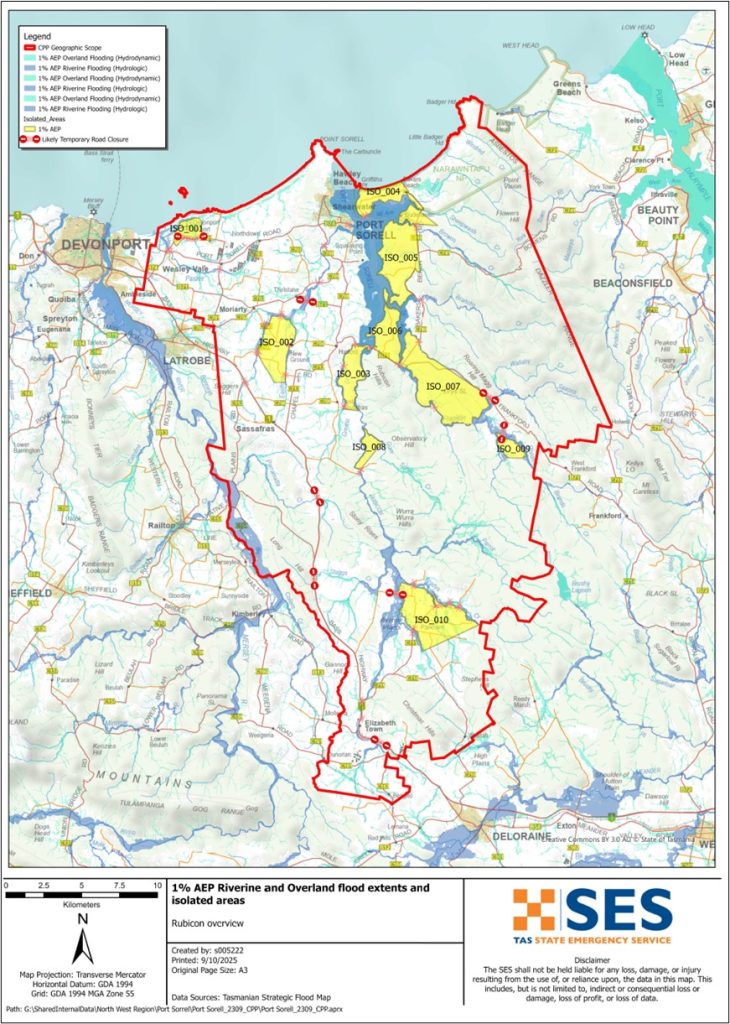
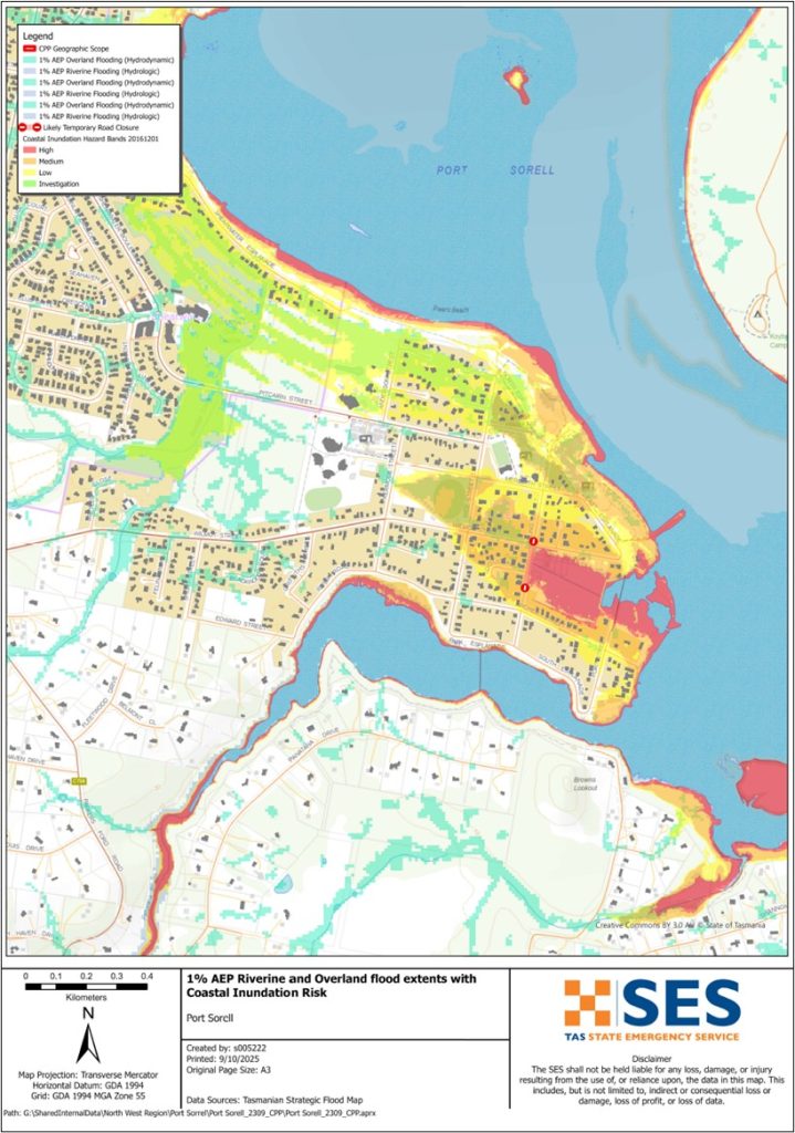
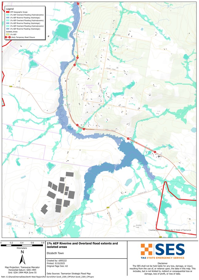
If the Rubicon River has a major flood, low lying areas near the river can flood. Floodwater can cut roads such as
- Bass Highway near Elizabeth Town
- Port Sorell Road, and
- Local streets like Rice Street and Seabreeze Avenue in several places.
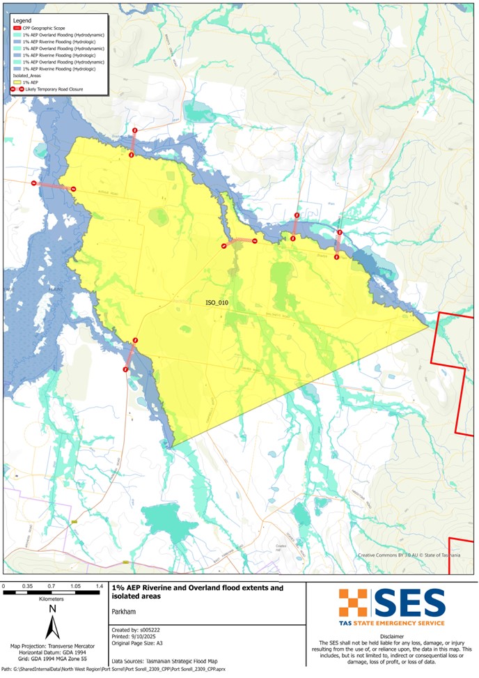
If there is heavy local rain, other areas can also have flash flooding from local waterways such as
- Panatana Rivulet
- Pardoe Creek, and
- Franklin Rivulet.
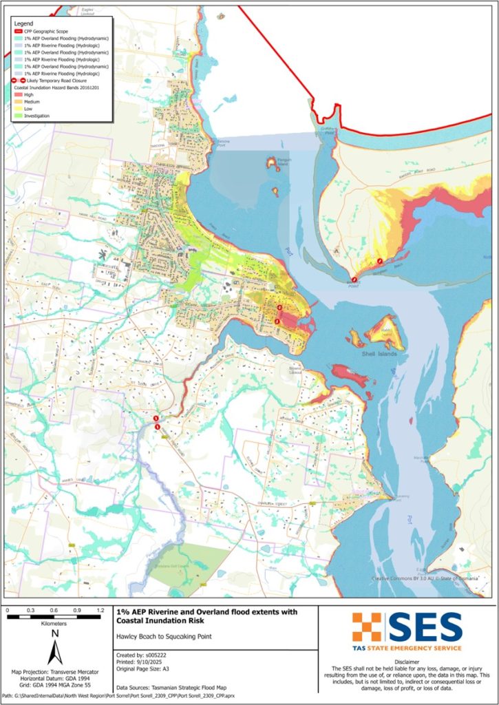
In a flash flood, you cannot rely on flood warnings from rivers, only forecasts for heavy rain or severe weather. Higher than usual tides and storms may also increase the risk of flooding in lower lying areas surrounding the Port Sorell waterway.
The maps in this guide show the level of flooding that has a 1% chance of happening any year. You are likely to experience flooding such as that shown in the maps in your lifetime. Tasmanians need to prepare for flood events that may not happen often, as well as the minor flooding they may have experienced.
Even if your home is not inundated, you should be prepared for isolation plus potential power and telecommunications outages. Depending on where the rain falls and how heavy it is, roads throughout the area may be impassable. Travel in the area is likely to be difficult or impossible until the roads are clear. If you are safe at home or elsewhere, it is usually best you stay where you are until the flooding subsides, unless there is an emergency. If you need to evacuate, you should leave early, before flood water rises.
Listen to ABC local radio 91.7FM for warnings and advice.
Adakah anda berisiko banjir?
The Rubicon River has a history of flooding with flooding impacts seen as recently as 2022.
Apa yang patut saya buat?
- Check the map to see whether your home or business could flood.
- Nilai rumah atau perniagaan anda dan bersiap sedia untuk meminimumkan kemungkinan kerosakan banjir.
- Periksa sama ada anda dapat sampai ke rumah, tempat kerja atau sekolah dengan selamat semasa banjir.
- Prepare a Home Emergency Plan. Consider if you need to evacuate before a flood. See Bersedia untuk Kecemasan– Panduan untuk individu dan isi rumah bersiap sedia menghadapi kecemasan.
- If you are a primary producer, the Farm Flood Readiness Kit provides advice on preparing for a flood to help protect your business and stock.
- If you run a business or other organisation, check out the Tasmanian Government’s Emergency Ready Business tool online
- Sekiranya anda terpencil dan perlu akses kepada perkhidmatan, anda mungkin perlu berpindah lebih awal.
- Jika anda berkhemah di kawasan yang mudah dinaiki banjir, pastikan anda sentiasa mendapatkan maklumat dan berpindah ke tempat yang lebih tinggi awal jika banjir berkemungkinan berlaku.
Floods like the one shown in the map, or worse, will occur again. No two floods are the same.
If you live in a low-lying area or near a watercourse, your house may flood. Even if your home is safe, you may need to detour around flooded areas or your road access may be cut. Never drive into or enter flood waters. Roads and bridges may be washed out or unsafe. Avoid travel during floods.
Mengetahui apa yang perlu dilakukan boleh menyelamatkan nyawa anda dan membantu melindungi harta benda anda. Mempunyai Pelan Kecemasan Rumah adalah salah satu cara terbaik untuk bersiap sedia. Tentukan pemicu cuaca dan hujan untuk masa bertindak.
Bureau of Meteorology Forecasts, Warnings, and Observations
The Bureau issues a Flood Warning, Severe Weather Warning and/or Thunderstorm Warning for heavy rainfall that may lead to flash flooding whenever heavy rain is expected in an area. The time between the warning andheavy rain occurring can vary from an hour to 24 hours or more.
Whenever rain that may lead to flooding along the Rubicon River is expected, the Bureau may issue a Flood Watch – a “heads up” early advice of forecast weather that may lead to flooding.
SES and the Bureau are unlikely to be able to issue specific local warnings when flooding impacts are observed in this area. There are no formal warning levels for other waterways in the area.
Rainfall Observations at Deloraine Railway Bridge, Kimberley and Devonport Airport and other nearby rain gauges can indicate possible flood risks. Given the very short warning times, it is best to act on the predictive BoM warnings rather than wait for any flood alerts during rainfall.
Rainfall may start impacting the area at the following thresholds:
-
- 90-145mm rainfall over 12-24 hours
-
- 160-230mm rainfall over 48-72hrs
Abnormally high tides may also cause flooding in low-lying coastal areas around the Port Sorell waterway near the mouth of the Rubicon River.
Ia West Takone is useful to be aware in real-time where heavy rainfall is falling. Radar rainfall estimates can also fill in gaps in areas where there are no rainfall stations.
Fahami amaran dan maklumat penting
Sentiasa peka dengan apa yang berlaku di sekeliling anda. Periksa ramalan, pemerhatian dan amaran dengan kerap.
 |
Nasihat (Kuning) Satu insiden telah berlaku. Tiada bahaya segera. Nantikan perkembangan sekiranya keadaan berubah. |
 |
Tonton dan Bertindak (Oren): Terdapat peningkatan tahap ancaman. Keadaan sedang berubah dan anda perlu mula mengambil tindakan sekarang untuk melindungi diri anda dan keluarga anda |
 |
Amaran Kecemasan (Merah): Amaran Kecemasan adalah tahap amaran tertinggi. Anda mungkin dalam bahaya dan perlu mengambil tindakan segera. Sebarang kelewatan kini meletakkan nyawa anda dalam risiko. |
 |
Kemas kini komuniti (Biru): Maklumat dan kemas kini khusus untuk komuniti yang terjejas mengenai peristiwa atau insiden tertentu. |
| Insiden (Putih) insiden adalah kejadian awal sebelum ia menjadi amaran kecemasan. Sebaik sahaja insiden dilaporkan, TasALERT menerbitkan maklumat asas termasuk jenis dan lokasi insiden. |
Paras banjir
Walaupun tiada dua banjir yang sama, berikut adalah penerangan tentang apa yang anda boleh jangka pada tahap banjir yang berbeza di sekitar kawasan. Walaupun harta benda anda tidak dinaiki air, anda perlu memikirkan tentang akses. Tahap hujan yang berbeza boleh menyebabkan banjir bergantung pada keamatan, tempoh dan seberapa basah tanah sebelumnya serta di mana hujan turun.
Minor to Moderate Flooding
Banjir kilat
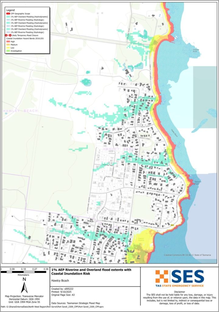
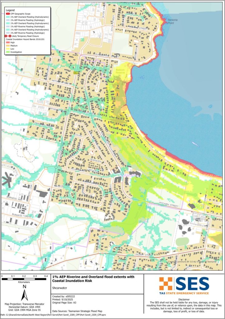
A minor flood can inundate low lying paddocks, orchards and other farmland. Stock should be moved for their safety. There may also be some flooding across some minor roads and parkland areas. Areas close to the shoreline may see some higher levels of flooding during higher tides.
Banjir sederhana
There is more extensive flooding of agricultural land and some buildings may be impacted to above floor height. Some properties may be isolated for a few hours as minor roads become flooded. For example, some properties may see flooding at:
-
- Port Sorell:
-
- Highwater Lane, Seahorse Lane and Rice Street.
-
- The Port Sorell Caravan park may begin to flood
-
- Hawley Beach:
-
- Sankey St
-
- Hawley St.
Banjir besar
If there is major flooding along the Rubicon River and other waterways, there may be flooding in low-lying areas close to the river. That level of flooding is approximately the level of the 2011, 2016 and 2022 floods and there is about a 5% chance of such a flood happening any year. Tasmanians need to be prepared for floods that have a 1% chance of happening every year.
Depending on where the rain falls and the level of soil saturation, this level of flooding is likely to:
-
- Flood some properties in low lying areas near the Rubican River, such as areas of Port Sorell and Shearwater.
-
- Close several roads in the area, including the Bass Highway, Port Sorell Road and other local roads isolating surrounding properties
-
- Isolate several parts of the community including parts of the Bakers Beach area, Narawntapu National Park, Harford and Frankford
-
- Flooding can impact Devonport Airport operations.
Go to TasALERT.com or listen to ABC local radio for detailed up to date information and advice during heavy rainfall events.
Ketahui risiko anda, bersiap sedia, kurangkan risiko di mana boleh, berhubung dengan orang lain, sentiasa berwaspada dan bertindak selamat.
Sebelum banjir
Bersedia untuk Kecemasan – Panduan untuk individu dan isi rumah bersiap sedia menghadapi kecemasan.
Ketahui risiko anda
Banjir sering berlaku di Tasmania dan boleh menyebabkan kerosakan yang meluas dan ketara. Dalam tempoh 200 tahun kebelakangan ini, terdapat 78 kematian berkaitan banjir di Tasmania. Panduan ini adalah untuk membantu anda memahami risiko banjir di kawasan anda.
2. Sediakan rumah anda
Miliki pelan kecemasan yang meliputi taufan dan banjir
Berfikir tentang apa yang akan anda lakukan semasa ribut atau banjir bermakna anda lebih bersedia dan semua orang lebih selamat. Miliki pelan kecemasan yang difahami oleh semua orang dalam isi rumah anda. Terdapat senarai semak untuk membantu anda memikirkan pelan anda – lihat Bersedia untuk Kecemasan – Panduan untuk individu dan isi rumah bersiap sedia menghadapi kecemasan.
Periksa pelan anda dengan kerap dan uji ia dengan setiap ahli isi rumah memikirkan senario banjir yang mungkin menjejaskan isi rumah anda.
Sediakan Kit Kecemasan
Sedia untuk Pergi
- Radio berkuasa bateri dan lampu suluh, bateri ganti
- Maklumat penting, seperti pelan kecemasan anda
- Senarai nombor kecemasan
- Makanan dan air
- Peti pertolongan cemas
- Sarung tangan getah atau kulit asli yang kukuh
Bungkus apabila perlu
- Pakaian hangat, kasut yang kukuh atau but
- Ubat-ubatan, cermin mata atau barangan penting lain
- Telefon bimbit dan pengecas telefon
- Makanan haiwan peliharaan dan apa sahaja yang mereka perlukan
- Foto dan kenang-kenangan istimewa
- Wang
- Dokumen penting, contohnya
-
- kertas insurans
-
- pasport dan
-
- Sijil kelahiran
Uji bateri dalam radio dan lampu suluh secara berkala.
3. Kurangkan risiko anda daripada banjir di mana anda boleh
- Pertimbangkan tentang ribut, banjir dan bahaya lain semasa membeli, menyelenggara atau membangunkan hartanah.
- Potong atau alih pokok dan dahan yang menjulur ke atas rumah, perniagaan anda atau berdekatan talian elektrik di kawasan anda.
- Pastikan saluran air dan perparitan anda bersih.
4. Berhubung dengan orang lain
Know your neighbours and get involved in your community. A connected community is a safer and more resilient community in an emergency and can help everyone recover better afterwards. Check that family and neighbours are safe and aware of what’s happening.
Semasa
5. Keep up to date
Sentiasa peka dengan apa yang berlaku di sekeliling anda. Periksa ramalan, pemerhatian dan amaran dengan kerap.
- yang Biro Meteorologi laman web.
6. Act Safe
- Mengawasi kanak-kanak.
- Bersiap sedia untuk kemungkinan gangguan bekalan elektrik, air atau internet.
- Pastikan peti kecemasan anda bersedia untuk digunakan.
- Jauhi kawasan yang dinaiki air seperti longkang. JANGAN SESEKALI berjalan, bermain, menunggang atau memandu dalam air banjir. Anda tidak selalu dapat melihat apa yang ada di bawah air atau betapa dalamnya atau derasnya air itu. Sangat mudah untuk dihanyutkan dan lemas dalam air yang bergerak pantas sedalam 20sm. Air banjir boleh berbahaya.
Bila rumah anda mungkin dinaiki air
- Letakkan barangan isi rumah di tempat yang tinggi untuk meminimumkan kerosakan yang mungkin berlaku.
- Padamkan bekalan elektrik dan gas jika selamat untuk berbuat demikian.
- Cara yang baik untuk menghentikan aliran kumbahan masuk semula ke rumah anda ialah dengan meletakkan beg pasir di dalam beg plastik dan menggunakannya untuk menyumbat tandas serta menutup longkang dan singki.
- Pergi selagi anda boleh keluar dengan selamat.
Jika anda perlu berpindah
- Ikuti nasihat dari SES / Polis Tasmania.
- Ambil kit kecemasan anda.
- Pergi ke tempat rakan atau keluarga yang lebih selamat atau pusat pemindahan.
- Beritahu orang lain ke mana anda telah pergi.
Jaga haiwan peliharaan anda
You are responsible for your animals in an emergency. If you have pets and other animals it will take you longer to evacuate in a flood or other emergency. Move livestock from flood prone areas well before flood waters may rise. For more information see
Elakkan melancong semasa ribut dan selepas ribut
- Jangan melancong. Pelancong melambatkan perkhidmatan kecemasan dan menyebabkan kemalangan.
- Berhati-hatilah terhadap bahaya seperti
-
- air di atas jalan
-
- talian elektrik rosak
-
- tanah runtuh
-
- jalan rosak
-
- pokok tumbang atau bumbung besi.
- Jangan memandu melalui air banjir. Kebanyakan kematian dan penyelamatan dalam banjir disebabkan oleh orang yang memandu melalui air banjir.
- Pandu perlahan dan pasang lampu hadapan anda di jalan yang tidak dinaiki banjir.
Selepas
- Terus ikuti perkembangan terkini dari ABC Local Radio, pembukaan semula jalan, mesyuarat komuniti, dll.
- Jika anda meninggalkan rumah anda, jangan pulang ke rumah sehingga SES atau Polis Tasmania memberitahu anda selamat untuk berbuat demikian.
- Berhati-hatilah terhadap bahaya jalan raya, seperti lumpur atau serpihan di jalan, jalan/jambatan yang rosak dan kru yang sedang bekerja membersihkan dan membaiki.
Jika rumah anda rosak
- Tinggal di aras tanah semasa memeriksa kerosakan. Berhati-hatilah dengan pokok tumbang, kaca pecah, bumbung yang longgar atau bahaya lain.
- Pakai but kuat, sarung tangan dan pakaian pelindung.
- Gunakan lampu suluh, jangan gunakan mancis atau lilin di dalam bangunan yang dinaiki banjir.
- Rebus semua air minuman sehingga anda diberitahu air paip selamat semula.
- Do not turn on it is tested by a licensed electrician or gas fitter for safety.
- Jika rumah anda rosak dan anda perlu menginap di tempat lain, bawa bersama kit kecemasan dan haiwan peliharaan anda
- Ambil gambar kerosakan jika selamat untuk anda berbuat demikian dan hubungi syarikat insurans anda.
- Mengawasi kanak-kanak.
- Periksa jiran dalam keadaan baik.
Untuk maklumat lanjut, sila layari www.ses.tas.gov.au
Kekal dimaklumkan dan maklumat lanjut
Current warnings – TasALERT.com
Emergency Broadcasters – stesen radio ABC tempatan anda
TASSES Social Media – facebook.com/sestasmania
Persediaan Menghadapi Kecemasan Banjir ses.tas.gov.au/flood-plan/
Perkhidmatan Geganti Kebangsaan (NRS) relayservice.gov.au
Local Emergency Broadcasters ABC 103.3 FM
Latrobe Council latrobe.tas.gov.au 6426 4444
Meander Valley Council meander.tas.gov.au 6393 5300
Penafian
The maps show potential flooding risks from consistent levels of rainfall across catchments, such as a 1% Annual Exceedance Probability (AEP). In flooding events, rainfall is likely to be more inconsistent across a catchment, so these flood maps should be considered indicative only. The mapped areas of flood risk show higher probability of inundation. Other areas have lower probability of flooding, but in severe and rare events (rarer than 1%AEP), other lower areas may be also at risk of inundation.
Maklumat dalam panduan ini adalah terkini pada tarikh penerbitannya. Walaupun segala usaha telah dibuat untuk memastikan kesahihan dan ketepatan data yang dibentangkan, Perkhidmatan Kecemasan Negeri tidak bertanggungjawab ke atas kesilapan atau ketinggalan data. Sila lihat piawaian Hak Cipta dan Pernyataan Penafian Kerajaan Tasmania untuk maklumat lanjut.
 Gambar