Panduan banjir kawasan yang dicedok-cedok bukan Launceston
Maklumat banjir sungai dan banjir kilat untuk komuniti dan hartanah di Launceston di luar kawasan yang dilindungi tembok
Untuk kawasan yang dilindungi benteng, lihat panduan banjir berkaitan untuk
- Newstead
- Invermay
- East Launceston dan Pusat Bandar Launceston, dan
- Launceston – Kawasan Margaret St.
Version 1.1 April 2026 – see the PDF version
Panduan banjir ini adalah untuk penduduk di kawasan Launceston yang tidak dilindungi oleh tembok banjir. Walaupun rumah anda tidak dinaiki air, semua orang di sekitar Launceston akan terjejas oleh banjir besar di bandar ini. Panduan ini juga merangkumi banjir kecil dan sederhana, serta banjir kilat di semua kawasan bandar.
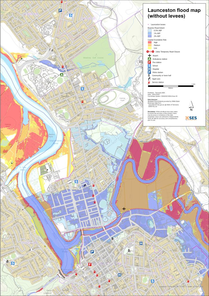
Bahagian Launceston boleh dinaiki air daripada
- Kanamaluka / Muara Sungai Tamar
- Sungai North Esk
- Sungai South Esk.
Terdapat juga beberapa laluan air kecil yang boleh menyebabkan banjir pada harta benda dan jalan raya.
Kawasan yang dilindungi oleh tembok penahan banjir Launceston
Takungan Launceston mengurangkan risiko banjir bagi banyak kawasan di sepanjang sungai utama. Walau bagaimanapun, tiada jaminan takungan akan bertahan daripada banjir besar. Pengalaman di negara lain menunjukkan bahawa takungan boleh gagal, baik secara berperingkat atau mendadak. Sekiranya takungan gagal, kawasan rendah di bandar ini mungkin tenggelam dengan cepat. Dalam banjir besar, penduduk di kawasan yang dilindungi takungan perlu berpindah sekiranya
- takat itu gagal, atau
- air banjir melimpahi benteng.
Sila rujuk panduan banjir berkaitan untuk kawasan yang dilindungi ban
- Newstead
- Invermay
- East Launceston dan Pusat Bandar Launceston, dan
- Launceston – Kawasan Margaret St.
Panduan-panduan ini untuk kawasan terlindung tebing sungai mempunyai maklumat penting mengenai
- pemicu evakuasi dalam peristiwa banjir besar
- cara berpindah, termasuk laluan pemindahan yang perlu digunakan.
Sekiranya Sungai Esk Utara dan/atau Esk Selatan boleh mencapai ketinggian tertentu, kawasan-kawasan ini akan mengalami:
- Amaran pemindahan sukarela – di mana orang ramai dinasihatkan untuk berpindah demi keselamatan mereka
- Amaran pemindahan wajib – di mana orang ramai perlu meninggalkan kawasan tersebut demi keselamatan mereka, dan gas, elektrik serta air dapat diputuskan untuk kawasan tersebut.
- Dalam kejadian banjir besar, orang di luar kawasan berisiko banjir perlu sedar bahawa
- Laluan lalu lintas utama melalui bandar mungkin ditutup
- Lalulintas kemungkinan besar akan sangat padat
- Mungkin ada pemotongan kepada beberapa perkhidmatan penting, seperti rawatan air.
- Mungkin akan ada pemotongan kepada beberapa perkhidmatan lain kerana laluan pengangkutan utama dipotong.
Kawasan yang boleh banjir di luar kawasan yang dilindungi oleh ban
Sungai boleh menyebabkan banjir di beberapa kawasan di luar kawasan yang dilindungi oleh tembok. Pasang surut air laut juga boleh meningkatkan paras air di kawasan yang lebih dekat dengan Sungai Tamar.
For more detailed flood maps, see www.launceston.tas.gov.au/Emergency-Management-Hub/1.-Understand-your-risk/Flood kepada
- Semak Peta Banjir Launceston untuk menilai tahap risiko banjir sungai anda.
- Semak Peta Banjir Bandar (Air Hujan) untuk peta banjir air hujan kilat.
- Ketahui lebih lanjut tentang tembok banjir Launceston.
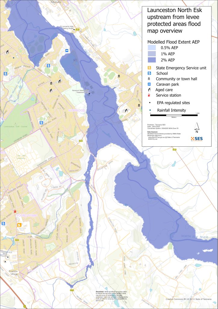
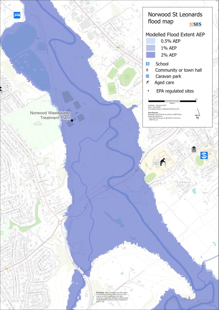
Kawasan rendah di sekitar Sungai North Esk
- Perkemahan budak pengakap Pulau Patersons di Corra Linn dan kolam ikan bersejarah berdekatan serta beberapa buah rumah
- St Leonards sekitar
- Jalan Stesen
- Jalan Hoblers Bridge
- Jalan Waverley
- Jalan Ravenswood
- Kawasan Norwood dan Newstead di luar kawasan yang dilindungi oleh tembok penahan, termasuk tapak perkhemahan di Sandown Road (Tanah Pertanian Old Mac)
- Waverley – Jalan Boomer
Kawasan dataran rendah sekitar South Esk dan Sungai Tamar
- Cataract Gorge Reserve – First Basin
- Daerah Pelabuhan
- Kawasan Kings Wharf
- Kawasan Lebuh Raya West Tamar
Kawasan rendah lain yang terdedah kepada banjir kilat/aliranan darat
Banjir kilat ialah banjir yang berlaku sejurus selepas hujan lebat. Selalunya tiada amaran awal selain daripada amaran cuaca buruk secara umum. Terdapat banyak laluan air kecil di sekitar Launceston yang boleh dinaiki air dengan cepat. Kawasan tanah rendah yang boleh dinaiki air akibat banjir kilat atau aliran permukaan termasuk sebahagian
- Relbia berdekatan Jinglers Creek
- Kingsmeadows/ Punchbowl
- Newnham – daripada banjir kilat dari Newnham Creek dan Barnards Creek
- Launceston Selatan
- Waverley
- Jalan Faraday dari Tasik Penyulingan
- Jalan Ravenswood dari Kolam Penyulingan/Sungai North Esk.
Sekiranya berlaku hujan yang sangat lebat, ia boleh menyebabkan aliran air hujan yang boleh menjejaskan bangunan dan jalan raya di mana-mana kawasan.
Kawasan sekitar Launceston
Untuk maklumat mengenai banjir di kawasan sekitar, lihat panduan berkaitan berdekatan untuk:
- Lilydale dan kawasan sekitarnya
- Nunamara and surrounds – currently under development
- Hadspen/ Blackstone Heights
Adakah anda berisiko banjir?
Kawasan Launceston mempunyai sejarah banjir yang panjang. Sejak penempatan Eropah
- 1852, 1863 dan 1893 mencatatkan kejadian banjir serius di Launceston.
- 1929 merupakan banjir paling teruk yang pernah direkodkan dalam sejarah moden. Lebih seribu rumah dan bangunan rosak, dengan ada yang hanyut dari tapaknya. Dua jambatan gantung di kawasan Gorge rosak. Empat ribu orang dipindahkan dari kawasan Invermay, Inveresk dan Margaret Street. Launceston hanya pulih dari banjir itu pada tahun 1940. Banjir tahun 1929 menjadi dorongan untuk membina benteng banjir.
- 2016 – Launceston bersedia menghadapi kejadian banjir besar dan menutup beberapa bendung. Peningkatan sistem bendung sebelum ini membantu mengelakkan kerugian kira-kira $216 juta sekiranya bendung lama sebelum ini gagal.
- 2022 – Launceston berdekatan terlepas daripada kejadian banjir besar.
Ramalan, Amaran, dan Pemerhatian Biro Meteorologi (BoM)
BoM mengeluarkan Amaran Banjir apabila cuaca yang diramalkan mungkin menyebabkan banjir di kawasan itu. Amarann Boleh:
- untuk kawasan tertentu seperti Sungai South Esk tadahan, contohnya, atau
- boleh digeneralisasikan seperti untuk Lembah sungai Utara Tengah
Isu BoM Amaran Banjir dengan ketinggian banjir spesifik untuk Sungai South Esk dan North Esk. Pengukur banjir di sepanjang sungai memberikan amaran tentang
- ketinggian banjir, dan
- kesan yang mungkin berlaku di Launceston.
Ombak pasang juga boleh menambah banjir.
Biro akan mengeluarkan amaran banjir Kecil, Sederhana atau Besar apabila Sungai North Esk atau Sungai South Esk berkemungkinan mencapai ketinggian tertentu. Jadual di bawah juga menunjukkan peringkat pencetus untuk SES mengeluarkan amaran pemindahan disebabkan banjir dari sungai-sungai ini.
| Laman pengecat sungai | Risih | Sederhana | Banjir besar | Titik Keputusan Kritikal Evakuasi |
| Sungai North Esk @ Corra Linn |
2.7 mAHD 80 m³/s |
3.6 mAHD 200 m³/s |
4.9 mAHD 419 m³/s Anggaran 20% AEP |
6.1 mAHD 800 m³/s Berkenaan 2% AEP Kawasan yang Dilindungi Penahan Air Newstead (LPA) |
| Sungai South Esk @ Kolam Trevallyn |
128.2 mAPL lebih kurang 420 m³/s 20% AEP |
129.9 mAHD lebih kurang. 1500 m³/s Approx. 10%AEP |
130.9 mAHD lebih kurang. 2,000 m³/s Anggaran 5% AEP |
2250 m³/s Antara 2%-1% AEP Kawasan yang Dilindungi Empangan Invermay / Inveresk |
|
2500 m³/s – Antara <1% AEP Bandar / Kawasan Dilindungi Levee East Launceston |
||||
|
3500 m³/s – Antara >1% AEP Kawasan Lindungan Tebat Margaret Street |
Nota:
- m³/s (cumec) – satu meter padu air mengalir melalui satu titik dalam satu saat. Satu meter padu air bersamaan dengan seribu liter dan beratnya satu tan.
- Annual Exceedance Probability (%AEP) is the likelihood of such an event happening any given year, based on historical records up to 2016. With climate change, this likelihood is changing. Updates of this data is underway.
- mAHD – Meter di atas garisan dasar ketinggian. Ini adalah ketinggian tempatan untuk tapak cerakinan.
Apa yang patut saya buat?
-
- Check the map to see whether your home or business could flood.
-
- Nilai rumah atau perniagaan anda dan bersiap sedia untuk meminimumkan kemungkinan kerosakan banjir.
-
- Periksa sama ada anda dapat sampai ke rumah, tempat kerja atau sekolah dengan selamat semasa banjir.
-
- Prepare a Home Emergency Plan. Consider if you need to evacuate before a flood. See Bersedia untuk Kecemasan– Panduan untuk individu dan isi rumah bersiap sedia menghadapi kecemasan.
-
- If you are a primary producer, the Farm Flood Readiness Kit provides advice on preparing for a flood to help protect your business and stock.
-
- If you run a business or other organisation, check out the Tasmanian Government’s Emergency Ready Business tool online
-
- Sekiranya anda terpencil dan perlu akses kepada perkhidmatan, anda mungkin perlu berpindah lebih awal.
-
- Jika anda berkhemah di kawasan yang mudah dinaiki banjir, pastikan anda sentiasa mendapatkan maklumat dan berpindah ke tempat yang lebih tinggi awal jika banjir berkemungkinan berlaku.
Floods like the one shown in the map, or worse, will occur again. No two floods are the same.
If you live in a low-lying area or near a watercourse, your house may flood. Even if your home is safe, you may need to detour around flooded areas or your road access may be cut. Never drive into or enter flood waters. Roads and bridges may be washed out or unsafe. Avoid travel during floods.
Mengetahui apa yang perlu dilakukan boleh menyelamatkan nyawa anda dan membantu melindungi harta benda anda. Mempunyai Pelan Kecemasan Rumah adalah salah satu cara terbaik untuk bersiap sedia. Tentukan pemicu cuaca dan hujan untuk masa bertindak.
Ramalan, Amaran, dan Pemerhatian Biro Meteorologi (BoM)
BoM mengeluarkan Amaran Banjir apabila cuaca yang diramalkan mungkin menyebabkan banjir di kawasan itu. Amarann Boleh:
- untuk kawasan tertentu seperti Sungai South Esk tadahan, contohnya, atau
- boleh digeneralisasikan seperti untuk Lembah sungai Utara Tengah
Isu BoM Amaran Banjir with specific flood heights for the South Esk and North Esk Rivers. Flood gauges along the rivers give warnings of
- ketinggian banjir, dan
- kesan yang mungkin berlaku di Launceston.
Ombak pasang juga boleh menambah banjir.
The Bureau will issue Minor, Moderate or Major flood warnings when the North Esk or South Esk Rivers are likely to reach certain heights. The table below also shows the trigger levels for SES to issue evacuation warnings due to flooding from these rivers.
| Laman pengecat sungai | Risih | Sederhana | Banjir besar | Titik Keputusan Kritikal Evakuasi |
| Sungai North Esk @ Corra Linn | 2.7 mAHD
80 m³/s |
3.6 mAHD
200 m³/s |
4.9 mAHD
419 m³/s Anggaran 20% AEP |
6.1 mAHD
800 m³/s Berkenaan 2% AEP Kawasan yang Dilindungi Penahan Air Newstead (LPA) |
| Sungai South Esk @ Kolam Trevallyn | 128.2 mAPL lebih kurang 420 m³/s
20% AEP |
129.9 mAHD lebih kurang.
1500 m³/s Approx. 10%AEP |
130.9 mAHD lebih kurang.
2,000 m³/s Anggaran 5% AEP |
2250 m³/s
Antara 2%-1% AEP Kawasan yang Dilindungi Empangan Invermay / Inveresk |
| 2500 m³/s – Antara <1% AEP
Bandar / Kawasan Dilindungi Levee East Launceston |
||||
| 3500 m³/s – Antara >1% AEP
Kawasan Lindungan Tebat Margaret Street |
Nota:
- m³/s (cumec) – satu meter padu air mengalir melalui satu titik dalam satu saat. Satu meter padu air bersamaan dengan seribu liter dan beratnya satu tan.
- Annual Exceedance Probability (%AEP) is the likelihood of such an event happening any given year, based on historical records up to 2016. With climate change, this likelihood is changing. Updates of this data is underway.
- mAHD – Meter di atas garisan dasar ketinggian. Ini adalah ketinggian tempatan untuk tapak cerakinan.
Fahami amaran dan maklumat penting
Sentiasa peka dengan apa yang berlaku di sekeliling anda. Periksa ramalan, pemerhatian dan amaran dengan kerap.
 |
Nasihat (Kuning) Satu insiden telah berlaku. Tiada bahaya segera. Nantikan perkembangan sekiranya keadaan berubah. |
 |
Tonton dan Bertindak (Oren): Terdapat peningkatan tahap ancaman. Keadaan sedang berubah dan anda perlu mula mengambil tindakan sekarang untuk melindungi diri anda dan keluarga anda |
 |
Amaran Kecemasan (Merah): Amaran Kecemasan adalah tahap amaran tertinggi. Anda mungkin dalam bahaya dan perlu mengambil tindakan segera. Sebarang kelewatan kini meletakkan nyawa anda dalam risiko. |
 |
Kemas kini komuniti (Biru): Maklumat dan kemas kini khusus untuk komuniti yang terjejas mengenai peristiwa atau insiden tertentu. |
| Insiden (Putih) insiden adalah kejadian awal sebelum ia menjadi amaran kecemasan. Sebaik sahaja insiden dilaporkan, TasALERT menerbitkan maklumat asas termasuk jenis dan lokasi insiden. |
Paras banjir
Walaupun tiada dua banjir yang sama, berikut adalah penerangan tentang apa yang anda boleh jangka pada tahap banjir yang berbeza di sekitar kawasan. Walaupun harta benda anda tidak dinaiki air, anda perlu memikirkan tentang akses. Tahap hujan yang berbeza boleh menyebabkan banjir bergantung pada keamatan, tempoh dan seberapa basah tanah sebelumnya serta di mana hujan turun.
Banjir kilat kecil di Sungai North Esk/South Esk dan Sungai Tamar
North Esk di Corra Linn sekurang-kurangnya 2.7m
- Tanah pertanian/taman tepi sungai, contohnya, kawasan piknik St Leonards
- Penutupan jalan yang mungkin berlaku – Henry Street
- Hartanah tanah rendah berhampiran sungai di:
- Jalan Stesen
- Jalan Henry
- Jalan Killafaddy
- Taman Karavan Old Mac's Farm di Sandown Road
- Laluan dan perkarangan kereta api Barat
- Taman Scotch Oakburn dan Taman Queechy
- South Esk di Kolam Trevallyn sekurang-kurangnya 128.2m
- Tanah pertanian/taman tepi sungai contohnya Cataract Gorge Reserve dan Kolam Renang Gorge, kawasan sekitar Home Point Parade
- Jeti Raja
- Kawasan rendah Seaport Home Point Parade
- Kelab mendayung West Tamar
- Kawasan Henry Street
- Air banjir mungkin mula memberi kesan kepada laluan selatan Lebuh Raya West Tamar, dengan lalu lintas dialihkan ke laluan alternatif.
Banjir sederhana dari Sungai North Esk/South Esk dan Tamar
- Ramai pintu laluan banjir akan ditutup, menyekat pergerakan melalui bandar. Laluan utama untuk melintasi sungai yang akan ditutup termasuk:
- Jalan West Tamar
- Jalan Henry
North Esk di Corra Linn sekurang-kurangnya 3.6m
Berikutan banjir kecil, ditambah
- Jalan Stesen jalan dan kawasan tanah rendah seterusnya berdekatan sungai
- Kawasan Henry Street dan kawasan rendah
- Oval/ bengkel Scotch Oakburn College
- Jalan Hoblers Bridge dan Pusat Bola Jaring
- Hartanah berpaya di Jalan Killafaddy
- Hartanah berpantai rendah di Glenwood Road
- Jalan Bill Grove, Mowbray.
- South Esk di Kolam Trevallyn sekurang-kurangnya 129.9m
- Mengikut banjir kecil bertambah
- Lebuhraya West Tamar kedua-dua arah dilencongkan melalui jalan sisi
- Jalan Seaport Boulevard
- Akan ada beberapa impak di sekitar Henry Street dan kawasan lain di bahagian hilir Sungai North Esk.
- 1600 m3/s @ Kolam Trevallyn – pengosongan sukarela sebahagian Invermay (lihat panduan banjir Invermay)
- Jalan Bill Grove, Mowbray.
Banjir utama sungai dari Sungai North Esk/South Esk dan Tamar
North Esk di Corra Linn sekurang-kurangnya 4.9m (Anggaran 20% AEP)
Mengikut banjir sederhana, ditambah:
- Tebat banjir Hart St ditutup, bahagian tebat Invermay ditutup
- Pintu air limbungan keretapi ditutup
- Persimpangan Sungai South Esk di Jalan Blessington
- Hartanah selanjutnya di Station Road
- Kawasan Sekolah Larmenier berhampiran sungai
- Pelbagai stesen pam kumbahan mungkin terjejas
- Jalan Johnson/ Jalan Stesen
- 800 m3/s @ Corra Linn- Newstead – Hart St area mandatory evacuation (Approx 2%AEP)
- South Esk di Kolam Trevallyn sekurang-kurangnya 130m (2000 m³/s)
- Mengikut banjir sederhana ditambah
- 2250 m³/s – Pindah keluar wajib Invermay – lihat panduan banjir Invermay
- 2500 m³/s – Benteng Invermay mungkin akan melimpah. Evakuasi wajib ke sebahagian pusat bandar Launceston – lihat panduan banjir untuk kawasan Launceston dan East Launceston/ Launceston – Margaret Street.,
- Bahagian kawasan Seaport, Kings Wharf dinaiki air
- Other areas – flash flooding from minor waterways (1-2%AEP)
- Banjir kilat dari laluan air kecil boleh berlaku dengan cepat, dengan amaran spesifik yang sedikit. Kawasan yang berisiko termasuk
- Jambatan Jalan Relbia dan beberapa kawasan rendah di sepanjang
- Jalan Relbia
- Redwood Crescent
- Jalan Oppossum
- Jalan Glenwood.
- Kings Meadows berhampiran Kings Meadows Rivulet, termasuk Hobart Road
- Kawasan rendah South Launceston berhampiran Margaret Street/Bathurst Street, termasuk Midland Highway berhampiran simpang Wellington Street, dan kawasan tanah rendah berhampiran
- Jalan dan kawasan perumahan rendah di Newstead, terutamanya berhampiran Jalan Robin
- Jalan dan hartanah di East Launceston sekitar Jalan Dowling.
- Newnham, Laluan Lilydale dan laluan kereta api Bell Bay di lintasan Barnards Creek, serta beberapa hartanah.
Peta-peta dalam panduan ini menunjukkan tahap banjir yang mempunyai kebarangkalian 1% untuk berlaku setiap tahun, sama ada dengan bendung melindungi beberapa kawasan, dan jika bendung gagal atau dilampaui. Ia tidak menunjukkan aliran permukaan/air limpahan hujan. Kecuali jika berlaku ribut teruk yang membawa hujan lebat, risiko utama banjir di Launceston berpunca daripada sungai-sungai utama bandar itu.
Dua sistem sungai utama Launceston mungkin banjir serentak dan mungkin mempunyai tahap banjir yang berbeza semasa kejadian yang sama. Sungai kanamaluka/Tamar adalah pasang surut dan mungkin juga mempengaruhi ketinggian banjir.
Anda berkemungkinan besar akan mengalami banjir seperti yang ditunjukkan dalam peta ini sepanjang hidup anda. Penduduk Tasmania perlu bersedia menghadapi kejadian banjir yang mungkin tidak kerap berlaku serta banjir kecil yang mungkin pernah mereka alami.
Dalam kejadian banjir besar, pintu kawalan empangan yang ditutup dan jalan raya yang dinaiki air boleh memisahkan bandar Launceston kepada tiga bahagian sehingga air surut:
- Pusat Perniagaan Utama dan kawasan di selatan pusat bandar
- Kawasan di utara dan timur laut Sungai North Esk/Tamar
- Kawasan Trevallyn/Riverside ke Barat dan Barat Laut Sungai Tamar
Bergantung pada taburan hujan di kawasan sekitar, mungkin terdapat laluan alternatif. Walau bagaimanapun, lalu lintas kemungkinan besar akan menjadi sangat sesak.
Walaupun rumah anda tidak dinaiki air, anda harus bersiap sedia untuk
- laluan trafik utama melalui bandar akan ditutup, dan
- potensi gangguan kuasa dan telekomunikasi.
Jika ada kawasan yang mengeluarkan perintah pengosongan mandatori untuk kawasan yang dilindungi oleh benteng, bekalan elektrik, air dan gas akan ditutup
- mengurangkan bahaya, dan
- lindungi aset agar dapat dipulihkan secepat mungkin selepas kejadian.
Perjalanan di kawasan itu mungkin sukar atau mustahil sehingga
- jalan lengang, dan
- pintu air dibuka semula.
Jika anda selamat di rumah atau di tempat lain, biasanya lebih baik anda terus berada di sana sehingga banjir surut, kecuali jika berlaku kecemasan. Sekiranya anda perlu berpindah, anda perlu beredar awal, sebelum air banjir naik.
Go to TasALERT.com or listen to ABC local radio for detailed up to date information and advice during heavy rainfall events.
Ketahui risiko anda, bersiap sedia, kurangkan risiko di mana boleh, berhubung dengan orang lain, sentiasa berwaspada dan bertindak selamat.
Sebelum banjir
Bersedia untuk Kecemasan – Panduan untuk individu dan isi rumah bersiap sedia menghadapi kecemasan.
Ketahui risiko anda
Banjir sering berlaku di Tasmania dan boleh menyebabkan kerosakan yang meluas dan ketara. Dalam tempoh 200 tahun kebelakangan ini, terdapat 78 kematian berkaitan banjir di Tasmania. Panduan ini adalah untuk membantu anda memahami risiko banjir di kawasan anda.
2. Sediakan rumah anda
Miliki pelan kecemasan yang meliputi taufan dan banjir
Berfikir tentang apa yang akan anda lakukan semasa ribut atau banjir bermakna anda lebih bersedia dan semua orang lebih selamat. Miliki pelan kecemasan yang difahami oleh semua orang dalam isi rumah anda. Terdapat senarai semak untuk membantu anda memikirkan pelan anda – lihat Bersedia untuk Kecemasan – Panduan untuk individu dan isi rumah bersiap sedia menghadapi kecemasan.
Periksa pelan anda dengan kerap dan uji ia dengan setiap ahli isi rumah memikirkan senario banjir yang mungkin menjejaskan isi rumah anda.
Sediakan Kit Kecemasan
Sedia untuk Pergi
-
- Radio berkuasa bateri dan lampu suluh, bateri ganti
-
- Maklumat penting, seperti pelan kecemasan anda
-
- Senarai nombor kecemasan
-
- Makanan dan air
-
- Peti pertolongan cemas
-
- Sarung tangan getah atau kulit asli yang kukuh
Bungkus apabila perlu
-
- Pakaian hangat, kasut yang kukuh atau but
-
- Ubat-ubatan, cermin mata atau barangan penting lain
-
- Telefon bimbit dan pengecas telefon
-
- Makanan haiwan peliharaan dan apa sahaja yang mereka perlukan
-
- Foto dan kenang-kenangan istimewa
-
- Wang
-
- Dokumen penting, contohnya
-
- kertas insurans
-
- pasport dan
-
- Sijil kelahiran
-
- Dokumen penting, contohnya
Uji bateri dalam radio dan lampu suluh secara berkala.
3. Kurangkan risiko anda daripada banjir di mana anda boleh
-
- Pertimbangkan tentang ribut, banjir dan bahaya lain semasa membeli, menyelenggara atau membangunkan hartanah.
-
- Potong atau alih pokok dan dahan yang menjulur ke atas rumah, perniagaan anda atau berdekatan talian elektrik di kawasan anda.
-
- Pastikan saluran air dan perparitan anda bersih.
4. Berhubung dengan orang lain
Know your neighbours and get involved in your community. A connected community is a safer and more resilient community in an emergency and can help everyone recover better afterwards. Check that family and neighbours are safe and aware of what’s happening.
Semasa
5. Keep up to date
Sentiasa peka dengan apa yang berlaku di sekeliling anda. Periksa ramalan, pemerhatian dan amaran dengan kerap.
-
- yang Biro Meteorologi laman web.
6. Act Safe
-
- Mengawasi kanak-kanak.
-
- Bersiap sedia untuk kemungkinan gangguan bekalan elektrik, air atau internet.
-
- Pastikan peti kecemasan anda bersedia untuk digunakan.
-
- Jauhi kawasan yang dinaiki air seperti longkang. JANGAN SESEKALI berjalan, bermain, menunggang atau memandu dalam air banjir. Anda tidak selalu dapat melihat apa yang ada di bawah air atau betapa dalamnya atau derasnya air itu. Sangat mudah untuk dihanyutkan dan lemas dalam air yang bergerak pantas sedalam 20sm. Air banjir boleh berbahaya.
Bila rumah anda mungkin dinaiki air
-
- Letakkan barangan isi rumah di tempat yang tinggi untuk meminimumkan kerosakan yang mungkin berlaku.
-
- Padamkan bekalan elektrik dan gas jika selamat untuk berbuat demikian.
-
- Cara yang baik untuk menghentikan aliran kumbahan masuk semula ke rumah anda ialah dengan meletakkan beg pasir di dalam beg plastik dan menggunakannya untuk menyumbat tandas serta menutup longkang dan singki.
-
- Pergi selagi anda boleh keluar dengan selamat.
Jika anda perlu berpindah
-
- Ikuti nasihat dari SES / Polis Tasmania.
-
- Ambil kit kecemasan anda.
-
- Pergi ke tempat rakan atau keluarga yang lebih selamat atau pusat pemindahan.
-
- Beritahu orang lain ke mana anda telah pergi.
Jaga haiwan peliharaan anda
You are responsible for your animals in an emergency. If you have pets and other animals it will take you longer to evacuate in a flood or other emergency. Move livestock from flood prone areas well before flood waters may rise. For more information see
Elakkan melancong semasa ribut dan selepas ribut
-
- Jangan melancong. Pelancong melambatkan perkhidmatan kecemasan dan menyebabkan kemalangan.
-
- Berhati-hatilah terhadap bahaya seperti
-
- air di atas jalan
-
- talian elektrik rosak
-
- tanah runtuh
-
- jalan rosak
-
- pokok tumbang atau bumbung besi.
-
- Berhati-hatilah terhadap bahaya seperti
-
- Jangan memandu melalui air banjir. Kebanyakan kematian dan penyelamatan dalam banjir disebabkan oleh orang yang memandu melalui air banjir.
-
- Pandu perlahan dan pasang lampu hadapan anda di jalan yang tidak dinaiki banjir.
Selepas
-
- Terus ikuti perkembangan terkini dari ABC Local Radio, pembukaan semula jalan, mesyuarat komuniti, dll.
-
- Jika anda meninggalkan rumah anda, jangan pulang ke rumah sehingga SES atau Polis Tasmania memberitahu anda selamat untuk berbuat demikian.
-
- Berhati-hatilah terhadap bahaya jalan raya, seperti lumpur atau serpihan di jalan, jalan/jambatan yang rosak dan kru yang sedang bekerja membersihkan dan membaiki.
Jika rumah anda rosak
-
- Tinggal di aras tanah semasa memeriksa kerosakan. Berhati-hatilah dengan pokok tumbang, kaca pecah, bumbung yang longgar atau bahaya lain.
-
- Pakai but kuat, sarung tangan dan pakaian pelindung.
-
- Gunakan lampu suluh, jangan gunakan mancis atau lilin di dalam bangunan yang dinaiki banjir.
-
- Rebus semua air minuman sehingga anda diberitahu air paip selamat semula.
-
- Do not turn on it is tested by a licensed electrician or gas fitter for safety.
-
- Jika rumah anda rosak dan anda perlu menginap di tempat lain, bawa bersama kit kecemasan dan haiwan peliharaan anda
-
- Ambil gambar kerosakan jika selamat untuk anda berbuat demikian dan hubungi syarikat insurans anda.
-
- Mengawasi kanak-kanak.
-
- Periksa jiran dalam keadaan baik.
Untuk maklumat lanjut, sila layari www.ses.tas.gov.au
Kekal dimaklumkan dan maklumat lanjut
Current warnings – TasALERT.com
Emergency Broadcasters – stesen radio ABC tempatan anda
TASSES Social Media – facebook.com/sestasmania
Persediaan Menghadapi Kecemasan Banjir ses.tas.gov.au/flood-plan/
Perkhidmatan Geganti Kebangsaan (NRS) relayservice.gov.au
Local Emergency Broadcasters ABC 91.7FM
Bandar Launceston Launceston.tas.gov.au 6323 3000
Hab Pengurusan Kecemasan Bandar Launceston
Penafian
The maps show potential flooding risks from consistent levels of rainfall across catchments, such as a 1% Annual Exceedance Probability (AEP). In flooding events, rainfall is likely to be more inconsistent across a catchment, so these flood maps should be considered indicative only. The mapped areas of flood risk show higher probability of inundation. Other areas have lower probability of flooding, but in severe and rare events (rarer than 1%AEP), other lower areas may be also at risk of inundation.
Maklumat dalam panduan ini adalah terkini pada tarikh penerbitannya. Walaupun segala usaha telah dibuat untuk memastikan kesahihan dan ketepatan data yang dibentangkan, Perkhidmatan Kecemasan Negeri tidak bertanggungjawab ke atas kesilapan atau ketinggalan data. Sila lihat piawaian Hak Cipta dan Pernyataan Penafian Kerajaan Tasmania untuk maklumat lanjut.
 Gambar