Launceston non-levee protected areas flood guide
Riverine flooding and flash flooding information for communities and properties in Launceston outside the levee protected areas
For levee protected areas, see the related flood guides for
Version 1.1 April 2026 – see the PDF version
This flood guide is for people in the areas of Launceston not protected by levees. Even if your home is not flooded, everyone around Launceston would be impacted by a major flood in the city. This guide also covers minor and moderate flooding, plus flash flooding in all areas of the city.
Parts of Launceston can flood from the
- kanamaluka / River Tamar Estuary
- North Esk River
- South Esk River.
There are also some minor waterways that can flood properties and roadways.
Launceston levee protected areas
Launceston’s levees reduce flood risk for many areas along the major rivers. However, there is no guarantee the levees will withstand a major flood. Experiences in other countries show that levees can fail, both gradually and suddenly. If the levees fail, low lying parts of the city may flood quickly. In major floods, people in the levee protected areas should evacuate in case
- the levees fail, or
- flood waters overtop the levees.
Please see the related flood guides for the levee protected areas of
These guides for the levee protected areas have important information about
- triggers for evacuation in major flood events
- how to evacuate, including evacuation routes to use.
If the North and/or South Esk Rivers may reach certain heights, these areas will have:
- A voluntary evacuation warning – where people are advised to leave for their safety
- A mandatory evacuation warning – where people should leave those areas for their safety, and so gas, electricity and water can be cut for those areas.
- In major flood events, people outside flood prone areas need to be aware that
- Major traffic routes through the city may be cut
- Traffic is likely to be very heavy
- There may be cuts to some essential services, such as water treatment.
- There may be cuts to some other services as major transport routes are cut.
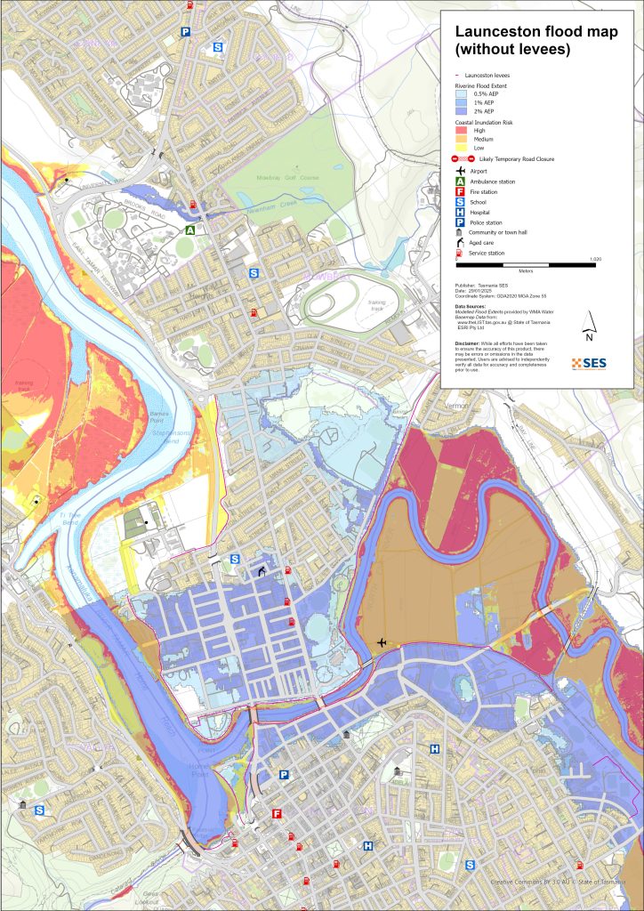
Areas that can flood outside the levee protected areas
Rivers can flood some areas outside the levee protected areas. High tides can also increase water levels in areas closer to the River Tamar.
For more detailed flood maps, see www.launceston.tas.gov.au/Emergency-Management-Hub/1.-Understand-your-risk/Flood to
- Check the Launceston Flood Maps to assess your level of riverine flood risk.
- Check the Urban (Stormwater) Flooding Map for flash flooding storm water flood maps.
- Find out more about Launceston’s flood levees.
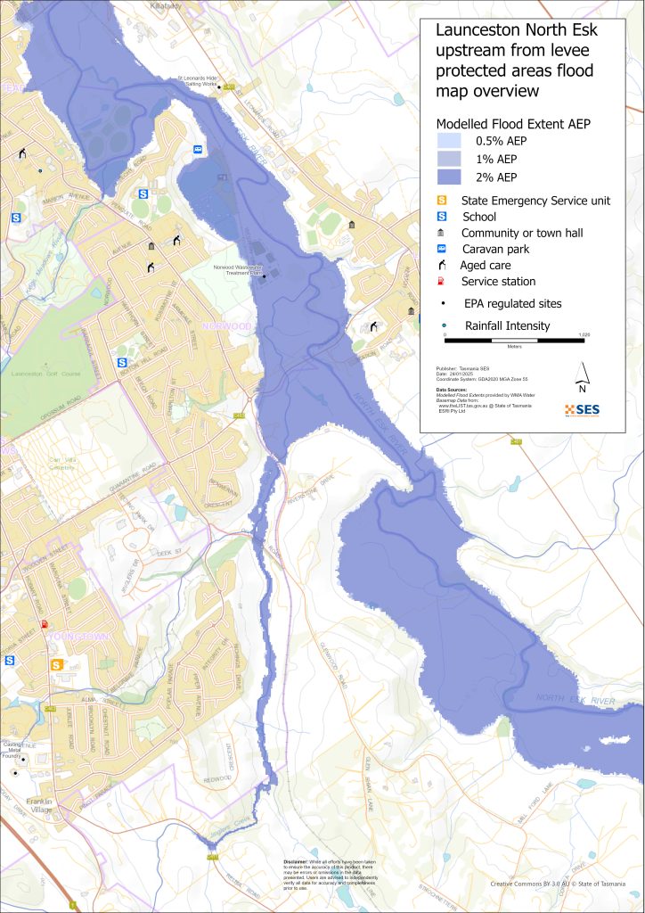
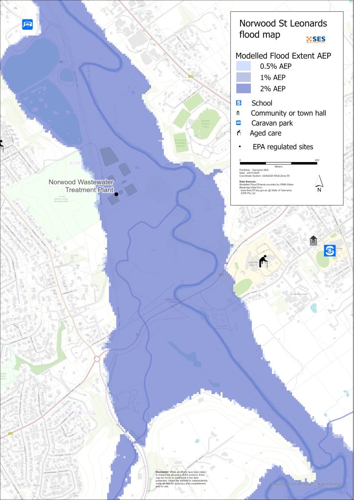
North Esk River surrounding low-lying areas
- Corra Linn, Patersons Island scout camp and nearby historic fishponds plus some homes
- St Leonards around
- Station Road
- Hoblers Bridge Road
- Waverley Road
- Ravenswood Road
- Norwood and Newstead areas outside the levee protected area, including the caravan park on Sandown Road (Old Mac’s Farm)
- Waverley – Boomer Road
South Esk and River Tamar low-lying surrounding areas
- Cataract Gorge Reserve – First Basin
- Seaport Precinct
- Kings Wharf area
- West Tamar Highway area
Other low-lying areas exposed to flash flooding/ overland flow
Flash flooding is flooding that happens very soon after heavy rain falls. There can often be little warning aside from a general severe weather warning. There are many minor waterways around Launceston that can flood quickly. Low-lying areas that can flood due to flash flooding or overland flow include parts of
- Relbia near Jinglers Creek
- Kingsmeadows/ Punchbowl
- Newnham – from flash flooding from Newnham Creek and Barnards Creek
- South Launceston
- Waverley
- Faraday Street from Distillery Creek
- Ravenswood Road from Distillery Creek/ North Esk River.
If there is very intense rain, there can be storm water run-off that can affect buildings and roads in any area.
Areas surrounding Launceston
For information about flooding in surrounding areas, see nearby related guides for:
- Lilydale and surrounds
- Nunamara and surrounds – currently under development
- Hadspen/ Blackstone Heights
Are you at risk of flood?
The Launceston area has a long history of flooding. Since European settlement
- 1852, 1863 and 1893 had serious flood events recorded for Launceston.
- 1929 was the most severe flooding recorded in modern history. Over a thousand homes and buildings were damaged, with some swept from their foundations. The two suspension bridges over the Gorge area were damaged. Four thousand people were evacuated from Invermay, Inveresk and Margaret Street areas. It was not until 1940 that Launceston recovered from the flood. The 1929 floods provided incentive to build the levees.
- 2016 – Launceston prepared for a major flood event and closed some levees. Previous upgrades of the levee system helped avoid losses of about $216 million, had the previous ageing levees failed.
- 2022 – Launceston narrowly escaped a major flooding event.
Bureau of Meteorology (BoM) Forecasts, Warnings, and Observations
The BoM issues a Flood Watch when predicted weather might cause floods in the area. A Flood Watch may:
- be for a specific area such as the South Esk River catchment, for example, or
- be generalised such as for Central North river basins
The BoM issue Flood Warnings with specific flood heights for the South Esk and North Esk Rivers. Flood gauges along the rivers give warnings of
- flood heights, and
- the possible impacts in Launceston.
High tides can also add to flooding.
The Bureau will issue Minor, Moderate or Major flood warnings when the North Esk or South Esk Rivers are likely to reach certain heights. The table below also shows the trigger levels for SES to issue evacuation warnings due to flooding from these rivers.
| River gauge sites | Minor | Moderate | Major flood | Evacuation Critical Decision Points |
| North Esk River @ Corra Linn |
2.7 mAHD 80 m³/s |
3.6 mAHD 200 m³/s |
4.9 mAHD 419 m³/s Approx. 20% AEP |
6.1 mAHD 800 m³/s About 2% AEP Newstead Levee Protected Area (LPA) |
| South Esk River @ Trevallyn Pond |
128.2 mAHD approx. 420 m³/s > 20% AEP |
129.9 mAHD approx. 1500 m³/s Approx. 10%AEP |
130.9 mAHD approx. 2,000 m³/s Approx. 5% AEP |
2250 m³/s Between 2%-1% AEP Invermay /Inveresk Levee Protected Area |
|
2500 m³/s – Between <1% AEP City /East Launceston Levee Protected Area |
||||
|
3500 m³/s – Between >1% AEP Margaret Street Levee Protected Area |
Notes:
- m³/s (cumec) – one cubic meter of water flowing past a point in one second. One cubic meter of water equals one thousand litres and weighs one tonne.
- Annual Exceedance Probability (%AEP) is the likelihood of such an event happening any given year, based on historical records up to 2016. With climate change, this likelihood is changing. Updates of this data is underway.
- mAHD – Metres above height datum. This is a local height for the gauging site.
What should I do?
-
- Check the map to see whether your home or business could flood.
-
- Assess your home or business and prepare it to minimise possible flood damage.
-
- Check if you can safely get to your home, work, or school during a flood.
-
- Prepare a Home Emergency Plan. Consider if you need to evacuate before a flood. See Get Ready for Emergencies– A guide for individuals and households to prepare for emergencies.
-
- If you are a primary producer, the Farm Flood Readiness Kit provides advice on preparing for a flood to help protect your business and stock.
-
- If you run a business or other organisation, check out the Tasmanian Government’s Emergency Ready Business tool online
-
- If you may be isolated and you must have access to services, you may need to evacuate early.
-
- If you are camping in a flood prone area, make sure you stay informed and move to higher ground early if a flood is likely.
Floods like the one shown in the map, or worse, will occur again. No two floods are the same.
If you live in a low-lying area or near a watercourse, your house may flood. Even if your home is safe, you may need to detour around flooded areas or your road access may be cut. Never drive into or enter flood waters. Roads and bridges may be washed out or unsafe. Avoid travel during floods.
Knowing what to do can save your life and help protect your property. Having a Home Emergency Plan is one of the best ways to prepare. Decide on weather and rainfall triggers for when to act.
Bureau of Meteorology (BoM) Forecasts, Warnings, and Observations
The BoM issues a Flood Watch when predicted weather might cause floods in the area. A Flood Watch may:
- be for a specific area such as the South Esk River catchment, for example, or
- be generalised such as for Central North river basins
The BoM issue Flood Warnings with specific flood heights for the South Esk and North Esk Rivers. Flood gauges along the rivers give warnings of
- flood heights, and
- the possible impacts in Launceston.
High tides can also add to flooding.
The Bureau will issue Minor, Moderate or Major flood warnings when the North Esk or South Esk Rivers are likely to reach certain heights. The table below also shows the trigger levels for SES to issue evacuation warnings due to flooding from these rivers.
| River gauge sites | Minor | Moderate | Major flood | Evacuation Critical Decision Points |
| North Esk River @ Corra Linn | 2.7 mAHD
80 m³/s |
3.6 mAHD
200 m³/s |
4.9 mAHD
419 m³/s Approx. 20% AEP |
6.1 mAHD
800 m³/s About 2% AEP Newstead Levee Protected Area (LPA) |
| South Esk River @ Trevallyn Pond | 128.2 mAHD approx. 420 m³/s
> 20% AEP |
129.9 mAHD approx.
1500 m³/s Approx. 10%AEP |
130.9 mAHD approx.
2,000 m³/s Approx. 5% AEP |
2250 m³/s
Between 2%-1% AEP Invermay /Inveresk Levee Protected Area |
| 2500 m³/s – Between <1% AEP
City /East Launceston Levee Protected Area |
||||
| 3500 m³/s – Between >1% AEP
Margaret Street Levee Protected Area |
Notes:
- m³/s (cumec) – one cubic meter of water flowing past a point in one second. One cubic meter of water equals one thousand litres and weighs one tonne.
- Annual Exceedance Probability (%AEP) is the likelihood of such an event happening any given year, based on historical records up to 2016. With climate change, this likelihood is changing. Updates of this data is underway.
- mAHD – Metres above height datum. This is a local height for the gauging site.
Understand the warnings and key information
Keep aware of what is happening around you. Check forecasts, observations and warnings regularly.
 |
Advice (Yellow): an incident has started. There is no immediate danger. Stay up to date in case the situation changes. |
 |
Watch and Act (Orange): There is a heightened level of threat. Conditions are changing and you need to start taking action now to protect you and your family |
 |
Emergency Warning (Red): An Emergency Warning is the highest level of warning. You may be in danger and need to take action immediately. Any delay now puts your life at risk. |
 |
Community update (Blue): Specific information and updates for affected communities regarding a particular event or incident. |
| Incident (White): an incident is the initial occurrence of an event before it becomes an emergency warning. As soon as an incident is reported, TasALERT publishes basic information including the type and location of incident. |
Flood levels
While no two floods are the same, the following describes what you can expect at different flood levels around the area. Even if your property is not flooded, you need to think about access. Different levels of rainfall can cause flooding depending on its intensity, duration and how wet the ground is beforehand and where the rain falls.
Minor Riverine flooding from North Esk/ South Esk and Tamar Rivers
North Esk at Corra Linn at least 2.7m
- Agricultural land/ riverside parklands, for example, St Leonards picnic ground
- Possible road closure – Henry Street
- Low-lying properties near the river on:
- Station Road
- Henry Street
- Killafaddy Street
- Old Mac’s Farm Caravan Park on Sandown Road
- Western railway line and yards
- Scotch Oakburn Park and Queechy Park
- South Esk at Trevallyn Pond at least 128.2m
- Agricultural land/ riverside parklands e.g. Cataract Gorge Reserve and Gorge Swimming Pool, Home Point Parade surrounds
- Kings Wharf
- Seaport Home Point Parade low lying areas
- West Tamar rowing club
- Henry Street area
- Flood waters may begin to impact the south-bound lane of the West Tamar Highway, with traffic diverted to alternate routes.
Moderate flooding from North Esk/ South Esk and Tamar Rivers
- Many levee flood gates will close, restricting movement through the city. Major routes to close across the river include:
- West Tamar Road
- Henry Street
North Esk at Corra Linn at least 3.6m
As per minor flooding, plus
- Station Road roadway and further low-lying properties near the river
- Henry Street further areas and low-lying properties
- Scotch Oakburn College oval/ workshop
- Hoblers Bridge Road and Netball Centre
- Low-lying properties on Killafaddy Road
- Low-lying properties on Glenwood Road
- Bill Grove roadway, Mowbray.
- South Esk at Trevallyn Pond at least 129.9m
- As per minor flooding plus
- West Tamar Highway both lanes diverted through side streets
- Seaport Boulevard
- There will be some impacts around Henry Street and other areas on the lower North Esk River
- 1600 m3/s @ Trevallyn Pond – voluntary evacuation parts of Invermay (see Invermay flood guide)
- Bill Grove roadway, Mowbray.
Major riverine flooding from North Esk/ South Esk and Tamar Rivers
North Esk at Corra Linn at least 4.9m (Approx 20% AEP)
As per moderate flooding, plus:
- Hart St flood levee closed, parts of Invermay levee closed
- Railyard flood gates are closed
- Blessington Road South Esk River crossing
- Further properties on Station Road
- Larmenier School grounds near the river
- Various sewage pump stations may be impacted
- Johnson Road/ Station Road
- 800 m3/s @ Corra Linn- Newstead – Hart St area mandatory evacuation (Approx 2%AEP)
- South Esk at Trevallyn Pond at least 130m (2000 m³/s)
- As per moderate flooding plus
- 2250 m³/s – Invermay Mandatory evacuation – see Invermay flood guide
- 2500 m³/s – Invermay levees may overtop. Mandatory evacuation of parts of Launceston city centre – see the flood guides for Launceston and East Launceston/ Launceston – Margaret Street area,
- Parts of Seaport area, Kings Wharf flooded
- Other areas – flash flooding from minor waterways (1-2%AEP)
- Flash flooding from minor waterways can happen quickly, with little specific warning. Areas at risk include
- Relbia Road bridge and some low-lying properties along
- Relbia Road
- Redwood Crescent
- Oppossum Road
- Glenwood Road.
- Kings Meadows near Kings Meadows Rivulet, including Hobart Road
- South Launceston low lying areas near Margaret Street/ Bathurst Street, including Midland Highway near the Wellington Street junction, and nearby low-lying properties
- Newstead low-lying roadways and properties, particularly near Robin Street
- East Launceston roadways and properties around Dowling St.
- Newnham, Lilydale Road and Bell Bay railway line at Barnards Creek crossing, plus several properties.
The maps in this guide show the level of flooding that has a 1% chance of happening any year, both with levee protecting some areas, and if the levees fail or are overtopped. They do not show overland flow/ rainwater run-off. Unless there is a severe storm bringing very heavy rain, the main flooding risks for Launceston are from the city’s major rivers.
Launceston’s two major river systems may flood at the same time and may have different levels of flooding during the same event. The kanamaluka/River Tamar is tidal and may also affect the flooding height.
You are likely to experience flooding such as that shown in the maps in your lifetime. Tasmanians need to prepare for flood events that may not happen often as well as the minor flooding they may have experienced.
In a major flood event, closed levee gates and flooded roads can cut the city of Launceston in three until waters recede:
- The Central Business District and areas to the south of the city centre
- Areas to the North and North East of the North Esk River/ Tamar
- Trevallyn/ Riverside area to the West and North West of the Tamar River
Depending on rainfall in surrounding areas, there may be alternative routes. However, traffic is likely to be very heavy.
Even if your home is not inundated, you should be prepared for
- major traffic routes through the city to be cut, and
- potential power and telecommunications outages.
If some areas there is a mandatory evacuation order for levee protected areas, electricity, water and gas will be switched off to
- reduce hazards, and
- protect assets so they can be restored as soon as possible after the event.
Travel in the area is likely to be difficult or impossible until
- roads are clear, and
- flood gates are reopened.
If you are safe at home or elsewhere, it is usually best you stay where you are until the flooding subsides, unless there is an emergency. If you need to evacuate, you should leave early, before flood waters rise.
Go to TasALERT.com or listen to ABC local radio for detailed up to date information and advice during heavy rainfall events.
Know your risk, get ready, reduce risk where you can, connect with others, stay alert and act safe.
Before a flood
Get Ready for Emergencies – A guide for individuals and households to prepare for emergencies.
1. Know your risk
Flooding often happens in Tasmania and can cause widespread and significant damage. In the past 200 years there have been 78 flood related deaths in Tasmania. This guide is to help you understand flood risk in your area.
2. Prepare your household
Have an emergency plan that covers storms and floods
Thinking about what you would do in a storm or flood means you are more prepared and everyone is safer. Have an emergency plan that everyone in your household understands. There are checklists to help you think through your plan – see Get Ready for Emergencies – A guide for individuals and households to prepare for emergencies.
Check your plan regularly and test it by everyone in the household thinking through a flooding scenario that may affect your household.
Prepare an Emergency Kit
Ready to Go
-
- Battery powered radio and torch, spare batteries
-
- Important information, such as your emergency plan
-
- A list of emergency numbers
-
- Food and water
-
- First aid kit
-
- Rubber or strong leather gloves
Pack when needed
-
- Warm clothes, sturdy shoes or boots
-
- Medicine, glasses or other essential items
-
- Mobile phone and phone charger
-
- Pet food and anything else they need
-
- Photos and special keepsakes
-
- Money
-
- Important documents, for example
-
- insurance papers
-
- passports and
-
- birth certificates
-
- Important documents, for example
Regularly test batteries in radios and torches.
3. Reduce your risk from flooding where you can
-
- Think about storms, flooding and other hazards when buying, maintaining or developing property.
-
- Trim or remove trees and branches overhanging your home, business or near powerlines on your property.
-
- Keep your gutters and drains clear.
4. Connect with others
Know your neighbours and get involved in your community. A connected community is a safer and more resilient community in an emergency and can help everyone recover better afterwards. Check that family and neighbours are safe and aware of what’s happening.
During
5. Keep up to date
Keep aware of what is happening around you. Check forecasts, observations and warnings regularly.
-
- the Bureau of Meteorology’s website.
6. Act Safe
-
- Supervise children.
-
- Prepare for possible power, water or internet outages.
-
- Check your emergency kit is ready to go.
-
- Keep clear of flooded areas such as drains. NEVER walk, play, ride or drive in floodwater. You can’t always see what is under the water or how deep or fast-moving the water is. It is easy to be swept away and drown in as little as 20cm of fast-moving water. Flood water can be dangerous.
When your home may be flooded
-
- Put household items up high to minimise possible damage.
-
- Turn off the electricity and gas if it is safe to do so.
-
- A great way to stop sewerage flowing back into your home is to place sandbags inside plastic bags and use them to block toilets and cover drains and sinks.
-
- Leave while you can get out safely.
If you need to evacuate
-
- Follow the advice from SES / Tasmania Police.
-
- Take your emergency kit.
-
- Go to friends or family in a safer place or an evacuation centre.
-
- Let others know where you have gone.
Look after your animals
You are responsible for your animals in an emergency. If you have pets and other animals it will take you longer to evacuate in a flood or other emergency. Move livestock from flood prone areas well before flood waters may rise. For more information see
Avoid travelling during storms and after storms
-
- Do not go sightseeing. Sightseers delay emergency services and cause accidents.
-
- Watch out for hazards such as
-
- water over roads
-
- damaged powerlines
-
- landslides
-
- damaged roads
-
- falling trees or roofing iron.
-
- Watch out for hazards such as
-
- Never drive through flood waters. Most deaths and rescues in floods are from people driving through flood waters.
-
- Drive slowly and turn your headlights on roads not affected by flood waters.
After
-
- Keep listening for ABC Local Radio updates, road re-openings, community meetings, etc.
-
- If you left your home, do not return home until SES or Tasmania Police tell you it is safe to do so.
-
- Be aware of road hazards, such as mud or debris on the road, damaged roads/bridges and crews working on clean-up and repairs.
If your home has been damaged
-
- Stay at ground level while checking for damage. Be careful of fallen trees, broken glass, loose roofing or other hazards.
-
- Wear strong boots, gloves and protective clothes.
-
- Use a torch, never use matches or candles inside flood affected buildings.
-
- Boil all drinking water until you are told the tap water is safe again.
-
- Do not turn on it is tested by a licensed electrician or gas fitter for safety.
-
- If your home is damaged and you need to stay somewhere else, take your emergency kit and pets with you
-
- Take photos of any damage if safe for you to do so and contact your insurance company.
-
- Supervise children.
-
- Check neighbours are okay.
For further information go to www.ses.tas.gov.au
Staying informed and further information
Current warnings – TasALERT.com
Emergency Broadcasters – your local ABC radio station
TASSES Social Media – facebook.com/sestasmania
Preparing for Flood Emergencies ses.tas.gov.au/flood-plan/
National Relay Service (NRS) relayservice.gov.au
Local Emergency Broadcasters ABC 91.7FM
City of Launceston Launceston.tas.gov.au 6323 3000
City of Launceston Emergency Management Hub
Disclaimer
The maps show potential flooding risks from consistent levels of rainfall across catchments, such as a 1% Annual Exceedance Probability (AEP). In flooding events, rainfall is likely to be more inconsistent across a catchment, so these flood maps should be considered indicative only. The mapped areas of flood risk show higher probability of inundation. Other areas have lower probability of flooding, but in severe and rare events (rarer than 1%AEP), other lower areas may be also at risk of inundation.
The information in this guide is current at the date of publication. While every effort has been taken to ensure the validity and accuracy of the data presented, the State Emergency Service does not take responsibility for data error or omission. Please see the standard Tasmanian Government’s Copyright and Disclaimer Statement for more details.
