朗塞斯頓非堤防保護區洪水指南
塔斯馬尼亞州朗塞斯頓 (Launceston) 堤防保護區以外的社區和物業的河流洪水和山洪暴發資訊
對於有堤防保護的地區,請參閱相關的洪水指南
Version 1.1 April 2026 – see the PDF version
這份洪水指南適用於朗塞斯頓未設有堤防保護的地區居民。即使您的住所未受洪水影響,朗塞斯頓市區發生嚴重洪水時,全市居民都會受到影響。本指南亦涵蓋市區所有地區的輕度、中度洪水,以及山洪暴發。.
launceston 的部分地區可能會發生洪災
- 卡納馬魯卡 / 塔瑪河河口
- 北艾斯克河
- 南艾斯克河.
還有一些小型水道可能會淹沒房產和道路。.
朗塞斯頓堤防保護區
蘭斯頓的堤防降低了主要河流沿岸許多地區的洪災風險。然而,堤防能否承受嚴重洪災並沒有保證。其他國家的經驗表明,堤防可能會逐漸或突然潰決。如果堤防潰決,城市低窪地區可能會迅速被淹沒。在嚴重洪災期間,受堤防保護區內的人們應撤離,以防萬一。
- 潰堤,或
- 洪水越过堤防。.
請參閱有關堤防保護區的相關洪水指南
這些用於堤防保護區的指南包含重要資訊,關於
- 重大洪水事件的撤離觸發因素
- 如何疏散,包括應使用的疏散路線。.
如果北河和/或南河可能達到特定高度,這些區域將會:
- 自願疏散警報 – 建議民眾為自身安全離開
- 強制撤離警告——人們應為了安全離開這些區域,以便切斷這些區域的燃氣、電力和水。.
- 在重大洪水事件中,居住在非易災區的人們需要意識到
- 城市的主要交通路線可能會被切斷
- 交通可能會非常擁擠
- 某些基本服務,例如水處理,可能會被削減。.
- 隨著主要交通路線被削減,其他一些服務可能也會受到影響。.
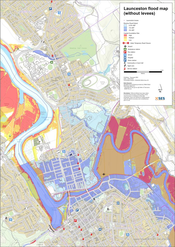
護堤保護區以外可能發生洪災的區域
河流可能淹沒堤防保護區以外的一些地區。漲潮也可能提高塔瑪河附近地區的水位。.
For more detailed flood maps, see www.launceston.tas.gov.au/Emergency-Management-Hub/1.-Understand-your-risk/Flood 到
- 請查看朗塞斯頓洪水地圖,以評估您的河流洪水風險等級。.
- 檢查城市(雨水)洪水地圖以獲取山洪暴發的雨水洪水地圖。.
- 了解更多關於朗塞斯頓的防洪堤。.
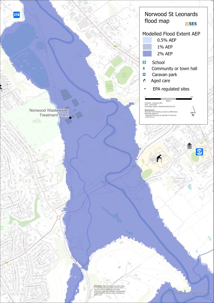
北艾斯克河周邊低窪地區
- 科拉林恩、帕特森島童子軍營地和附近的歷史悠久的魚池,以及一些房屋
- 聖李昂納多附近
- 車站路
- 霍布勒斯橋路
- 華弗里路
- 烏鴉森林路
- 包括位於 Sandown Road 的露營車公園(Old Mac’s Farm)在內的,位於堤防保護區以外的 Norwood 和 Newstead 地區
- 韋弗利 – 布墨路
南埃斯克河和塔瑪爾河低窪周邊地區
- 卡塔拉克特峡谷保护区 – 第一盆地
- 海港區
- 國王碼頭區
- 西塔馬爾公路區域
其他低窪地區易受山洪暴發/地表徑流影響
暴洪是指大雨過後很快發生的洪水。除了總體惡劣天氣警報外,通常幾乎沒有預警。勞恩塞斯頓周圍有許多小型水道,可能會迅速氾濫。低窪地區,因暴洪或地表徑流而可能發生洪水的區域包括
- 瑞爾比亞靠近靜林溪
- 京士美度/拳擊場
- 紐納姆 – 來自紐納姆溪和巴納德溪的閃洪
- 南朗塞斯頓
- 韋弗利
- 法拉第街(狄斯提勒瑞溪)
- Ravenswood Road 距離 Distillery Creek/North Esk River.
如果雨勢非常猛烈,可能會產生雨水逕流,進而影響任何地區的建築物和道路。.
朗塞斯頓周邊地區
如需了解附近地區的洪水資訊,請參閱相關指南:
- 利利戴爾及周邊地區
- Nunamara and surrounds – currently under development
- 哈斯登/布萊克史東高地
您有洪水風險嗎?
蘭斯頓地區有長久的水患歷史。自歐洲人定居以來
- 1852、1863 和 1893 年,朗塞斯頓均有嚴重洪水事件記錄。.
- 1929 年是有記錄以來最嚴重的洪水,對一千多戶房屋和建築物造成損壞,有些甚至被沖離地基。峽谷區的兩座懸索橋也受損。有四千人從因佛邁、因佛斯克和瑪格麗特街地區疏散。為應對這次洪水,直到 1940 年,朗塞斯頓才恢復元氣。1929 年的洪水促成了堤防的興建。.
- 2016 年 – 朗塞斯頓為一場重大洪水事件做好了準備,並關閉了一些堤防。先前對堤防系統的升級,若先前老化的堤防失效,原本約可避免 $2.16 億美元的損失。.
- 2022年 – 朗塞斯頓僥倖逃過一場嚴重的洪水事件。.
氣象局 (BoM) 預報、警報和觀測
國民黨發布了一份 洪水注意 當預測天氣可能導致該地區發生洪水時。洪水警戒可能:
- 適用於特定區域,例如 南埃斯克河 集水區,例如
- 可擴展為例如 中部北部河流流域
物料清单问题 洪水警告 針對South Esk河和North Esk河的特定洪水水位。沿河的洪水水位計發出預警
- 洪水高度,和
- 朗塞斯顿的可能影响.
漲潮也會加劇洪水。.
當北埃斯克河或南埃斯克河可能達到特定水位時,氣象局將發布輕度、中度或重大洪水警報。下表亦顯示了緊急服務署(SES)因這些河流氾濫而發布撤離警報的觸發水位。.
| 河川水位觀測站 | 未成年 | 適中 | 严重洪水 | 疏散關鍵決策點 |
| 北埃斯克河 @ 科拉林 |
2.7 毫安時 80 立方公尺/秒 |
3.6 毫安時 200 立方公尺/秒 |
4.9 毫安時 419 立方公尺/秒 約 20% AEP |
6.1 毫安時 800 立方公尺/秒 關於 2% AEP 新斯特德堤防保護區 |
| 南埃斯克河 @ 特里瓦林池塘 |
128.2 毫安時 約 420 立方公尺/秒 > 20% AEP |
129.9 毫安時 約. 1500 立方公尺/秒 Approx. 10%AEP |
130.9 公尺A高清 約. 2,000立方公尺/秒 約 5% AEP |
2250 立方公尺/秒 2% 至 1% 之間 AEP 英佛梅 / 英佛雷斯克堤防保護區 |
|
2500 立方公尺/秒 – 介於 <1% AEP 之間 城市 / 東朗塞斯頓堤防保護區 |
||||
|
3500 立方公尺/秒 – 介於 >1% AEP 之間 瑪格麗特街堤防保護區 |
筆記:
- 立方公尺/秒(cumec)– 每秒有一立方公尺的水流過一點。一立方公尺的水等於一千公升,重達一公噸。.
- Annual Exceedance Probability (%AEP) is the likelihood of such an event happening any given year, based on historical records up to 2016. With climate change, this likelihood is changing. Updates of this data is underway.
- mAHD – 海拔計。這是測量站的當地高度。.
我應該做什麼?
-
- 檢查地圖,看看您的住宅或企業是否可能遭受洪水侵襲。.
-
- 評估您的住家或公司,並做好準備以盡量減少潛在的洪水損害。.
-
- 檢查您是否能在洪水期間安全地抵達家中、工作地點或學校。.
-
- 準備一份居家緊急計畫。考慮是否需要在大水來臨前撤離。請參閱 為緊急情況做好準備– 為個人和家庭準備應急措施的指南。.
-
- If you are a primary producer, the Farm Flood Readiness Kit provides advice on preparing for a flood to help protect your business and stock.
-
- If you run a business or other organisation, check out the Tasmanian Government’s Emergency Ready Business tool online
-
- 如果你可能被隔離且必須取得服務,你可能需要提早撤離。.
-
- 如果你在容易發生洪水的地區露營,請確保隨時掌握最新資訊,並且在可能發生洪水時及早移往高處。.
像地圖所示的洪水,或更糟的洪水,將會再次發生。沒有兩次洪水是相同的。.
如果您居住在低窪地區或靠近水道,您的房屋可能會被淹沒。即使您的住所安全,您也可能需要繞過淹水地區,或者您的道路通行可能會被阻斷。切勿駕車進入或身處洪水之中。道路和橋樑可能會被沖毀或不安全。洪水期間請避免出行。.
知道該怎麼做可以拯救你的生命並保護你的財產。制定家庭緊急計畫是最好的準備方法之一。決定天氣和降雨的觸發條件,以便採取行動。.
氣象局 (BoM) 預報、警報和觀測
國民黨發布了一份 洪水注意 當預測天氣可能導致該地區發生洪水時。洪水警戒可能:
- 適用於特定區域,例如 南埃斯克河 集水區,例如
- 可擴展為例如 中部北部河流流域
物料清单问题 洪水警告 with specific flood heights for the South Esk and North Esk Rivers. Flood gauges along the rivers give warnings of
- 洪水高度,和
- 朗塞斯顿的可能影响.
漲潮也會加劇洪水。.
The Bureau will issue Minor, Moderate or Major flood warnings when the North Esk or South Esk Rivers are likely to reach certain heights. The table below also shows the trigger levels for SES to issue evacuation warnings due to flooding from these rivers.
| 河川水位觀測站 | 未成年 | 適中 | 严重洪水 | 疏散關鍵決策點 |
| 北埃斯克河 @ 科拉林 | 2.7 毫安時
80 立方公尺/秒 |
3.6 毫安時
200 立方公尺/秒 |
4.9 毫安時
419 立方公尺/秒 約 20% AEP |
6.1 毫安時
800 立方公尺/秒 關於 2% AEP 新斯特德堤防保護區 |
| 南埃斯克河 @ 特里瓦林池塘 | 128.2 毫安時 約 420 立方公尺/秒
> 20% AEP |
129.9 毫安時 約.
1500 立方公尺/秒 Approx. 10%AEP |
130.9 公尺A高清 約.
2,000立方公尺/秒 約 5% AEP |
2250 立方公尺/秒
2% 至 1% 之間 AEP 英佛梅 / 英佛雷斯克堤防保護區 |
| 2500 立方公尺/秒 – 介於 <1% AEP 之間
城市 / 東朗塞斯頓堤防保護區 |
||||
| 3500 立方公尺/秒 – 介於 >1% AEP 之間
瑪格麗特街堤防保護區 |
筆記:
- 立方公尺/秒(cumec)– 每秒有一立方公尺的水流過一點。一立方公尺的水等於一千公升,重達一公噸。.
- Annual Exceedance Probability (%AEP) is the likelihood of such an event happening any given year, based on historical records up to 2016. With climate change, this likelihood is changing. Updates of this data is underway.
- mAHD – 海拔計。這是測量站的當地高度。.
了解警告和關鍵資訊
隨時留意周遭狀況。定期查看天氣預報、觀測數據和警報。.
 |
建議 (黃色): 已發生事件。目前沒有立即危險。請隨時更新最新情況,以防局勢變動。. |
 |
觀察與行動(橘色): 威脅等級升高。情勢正在改變,您現在就必須採取行動保護您和您的家人。 |
 |
緊急警告(紅色): 緊急警報為最高級別的警報。您可能身處危險之中,需要立即採取行動。任何延誤都可能危及您的生命。. |
 |
社群更新(藍色): 針對特定事件或事故,向受影響社群提供的具體資訊和最新消息。. |
| 事件(白色): 事件是緊急警報發布前的初步發生。一旦事件被報告,TasALERT 就會發布基本資訊,包括事件的類型和地點。. |
洪水水位
雖然沒有兩次洪水是完全相同的,但以下描述了該地區在不同洪水水位下可能發生的情況。即使您的房產沒有被淹沒,您也需要考慮進出問題。不同程度的降雨都會導致洪水,這取決於降雨的強度、持續時間,以及事先的土壤濕度以及降雨發生的地點。.
北艾斯克河/南艾斯克河及塔瑪爾河的輕微河岸洪水
North Esk 在 Corra Linn 至少 2.7 公尺
- 農田/河濱公園,例如:聖李奧納德野餐區
- 道路可能關閉 – 亨利街
- 低窪地區近河岸的物業,位於:
- 車站路
- 亨利街
- 卡拉法迪街
- 山當路的老麥農場露營車公園
- 西方鐵路線路和場站
- 蘇格蘭橡樹公園和奎奇公園
- 南埃斯克河特里瓦林池塘,至少 128.2 公尺
- 農業用地/河畔公園如 Cataract Gorge Reserve 及 Gorge Swimming Pool、Home Point Parade 周邊
- 國王碼頭
- 港口住宅點閱兵低窪地區
- 西塔瑪鎮划船俱樂部
- 亨利街區
- 洪水可能開始影響西塔瑪灣公路的南行車道,交通將改道至其他路線。.
北艾斯克河/南艾斯克河和小溪河有中度洪水
- 許多堤防閘門將會關閉,限制市民在城市中的行動。跨河的主要通行路線將會關閉,包括:
- 西塔馬爾路
- 亨利街
北埃斯克河在科拉林瀑布,至少3.6米
依據局部淹水,加上
- 車站路道路以及更靠近河流的低窪地區
- 亨利街及其鄰近區域和低窪地區
- Scotch Oakburn College 運動場/工作坊
- 荷伯勒橋路和板球中心
- 吉拉法迪路 (Killafaddy Road) 的低窪地區
- 格倫伍德路的地勢較低的物業
- 比爾格羅夫路,莫布雷。.
- 南埃斯克河特里瓦林池塘,至少129.9公尺
- 依據輕度洪水加上
- 西塔瑪河公路雙向車道繞行至側街
- 海港大道
- 亨利街和下諾斯克河(Lower North Esk River)其他地區將會受到一些影響
- 1600立方公尺/秒 @ Trevallyn 水塘 – Invermay 部分地區自願疏散(請參閱 Invermay 洪水指南)
- 比爾格羅夫路,莫布雷。.
北埃斯克河/南埃斯克河及塔馬爾河的嚴重河岸洪水
科拉林(Corra Linn)的北埃斯克河(North Esk)水位至少達4.9公尺(約20% AEP)
按照中度洪水,外加:
- 哈特街潰堤已關閉,因弗梅橋潰堤部分關閉
- 貨場的水閘已關閉
- 布萊辛頓路南埃斯克河過河點
- Station Road 的進一步物業
- 拉爾門尼耶學校在河邊的校園
- 多個污水泵站可能會受到影響
- 強森路/車站路
- 800 m3/s @ Corra Linn- Newstead – Hart St area mandatory evacuation (Approx 2%AEP)
- 南埃斯克河特雷瓦林池塘 至少130米 (2000立方米/秒)
- 按照中度洪水加
- 2250 立方公尺/秒 – 因弗梅(Invermay)強制撤離 – 請參閱因弗梅(Invermay)洪水指南
- 2500 立方公尺/秒 – 因弗梅(Invermay)堤防可能潰決。強制疏散朗塞斯頓(Launceston)市中心部分區域 – 請參閱朗塞斯頓與東朗塞斯頓/朗塞斯頓 – 瑪格麗特街(Margaret Street)地區的洪水指南。,
- 海港區部分地區和國王碼頭洪水氾濫
- Other areas – flash flooding from minor waterways (1-2%AEP)
- 來自小型水道的閃洪可能會迅速發生,幾乎沒有具體的預警。有風險的區域包括
- 瑞爾比亞路橋以及沿岸一些低窪地區
- 雷爾比亞路
- 紅木彎
- 負鼠路
- 格倫伍德路.
- 國王草甸(Kings Meadows)鄰近國王草甸溪(Kings Meadows Rivulet),包括霍巴特路(Hobart Road)
- 南朗塞斯頓近瑪格麗特街/巴瑟斯特街的低窪地區,包括惠靈頓街交界處附近的米德蘭公路,以及附近的低窪物業
- Newstead 地勢低窪的道路和房產,特別是 Robin Street 附近
- 東勞恩塞斯頓(East Launceston)的道路及Dowling St(道靈街)附近的物業。.
- 紐恩罕、莉莉戴爾路及貝爾灣鐵路線上的巴拿德溪平交道,以及數處房產。.
本指南中的地圖顯示了每年發生機率為 1% 的洪水水位,分別呈現堤防保護部分區域的情況,以及堤防潰決或被洪水漫頂的情況。這些地圖未顯示地表徑流/雨水徑流。 除非有強烈風暴帶來極大暴雨,否則朗塞斯頓的主要洪水風險源自市內的主要河流。.
朗塞斯頓的兩個主要河流系統可能會同時發生洪水,甚至在同一場洪水事件中出現不同程度的淹水。塔瑪河/卡納馬魯卡河是潮汐河,也可能影響洪水的高度。.
您一生中很可能會遇到地圖所示的洪水。塔斯馬尼亞居民需要為不常發生但可能發生的洪水事件,以及他們可能經歷過的較輕微洪水做好準備。.
在重大洪水事件中,關閉的堤壩閘門和被淹沒的道路可能會將朗塞斯頓市隔離成三部分,直到洪水退去:
- 中環商業區及市中心以南區域
- 北區與東北區,介於北艾斯克河/塔瑪河之間
- 塔瑪河以西和西北的Trevallyn/Riverside地區
根據周邊地區的降雨量,可能有替代路線。但是,交通可能會非常繁忙。.
即使您的房屋沒有被淹沒,您也應該為以下情況做好準備:
- 市區的主要交通路線將被切斷,
- 潛在的電力和電信中斷。.
如果堤防保護區有強制撤離命令,電力、水和燃氣將被關閉。
- 降低危害,並
- 保護資產,以便在事件發生後盡快恢復。.
該地區的旅行可能會很困難,甚至不可能,直到
- 道路暢通,而且
- 水閘重開。.
如果在住家或其他地方是安全的,最好待在原地直到洪水消退,除非有緊急情況。如果需要撤離,應提早離開,在洪水上漲前。.
Go to TasALERT.com or listen to ABC local radio for detailed up to date information and advice during heavy rainfall events.
了解你的風險,做好準備,盡可能降低風險,與他人聯繫,保持警惕並安全行動。.
洪水之前
為緊急情況做好準備 – 為個人和家庭準備應急措施的指南。.
1. 認識你的風險
塔斯馬尼亞經常發生洪水,可能造成廣泛且嚴重的損害。在過去 200 年裡,塔斯馬尼亞有 78 人死於與洪水相關的事件。本指南旨在幫助您了解您所在地區的洪水風險。.
2. 準備您的家戶
制定包含風暴和洪水應變計畫
思考一下在風暴或洪水來襲時你會怎麼做,意味著你準備得更充分,每個人都會更安全。制定一個家庭中的每個人都理解的緊急計畫。有檢查表可以幫助你思考你的計畫——請參閱 為緊急情況做好準備 – 為個人和家庭準備應急措施的指南。.
定期檢查您的計劃,並讓家中的每個人都設想一次可能影響您家的洪水情況來進行測試。.
準備一個緊急救生包
準備好了
-
- 電池供電的收音機和手電筒,備用電池
-
- 重要資訊,例如您的緊急應變計畫
-
- 緊急電話號碼列表
-
- 食物和水
-
- 急救箱
-
- 橡膠手套或堅固的皮革手套
需要時打包
-
- 暖和的衣服、結實的鞋子或靴子
-
- 藥品、眼鏡或其他必需品
-
- 手機和充電器
-
- 寵物食品和他們需要的任何其他東西
-
- 照片和特別紀念品
-
- 錢
-
- 重要文件,例如
-
- 保險文件
-
- 護照與
-
- 出生證明
-
- 重要文件,例如
定期測試收音機和手電筒的電池。.
3. 在可能的情況下,降低您遭受洪水侵襲的風險
-
- 在購買、維護或開發房地產時,請考慮風暴、洪水和其他災害。.
-
- 修剪或移除您家中、商家或您家附近有電力線的樹木和樹枝。.
-
- 保持您的排水溝和排水管暢通。.
4. 與他人建立聯繫
Know your neighbours and get involved in your community. A connected community is a safer and more resilient community in an emergency and can help everyone recover better afterwards. Check that family and neighbours are safe and aware of what’s happening.
期間
5. 保持更新
隨時留意周遭狀況。定期查看天氣預報、觀測數據和警報。.
-
- 這 氣象局 網站.
6. 保持安全
-
- 監督兒童.
-
- 為可能的停電、停水或斷網做好準備。.
-
- 檢查您的緊急救助包是否已準備就緒。.
-
- 切勿靠近淹水區域,例如排水溝。. 永不 在洪水中有行走、玩耍、骑行或开车。你無法確定水下有什麼,或水有多深、流速有多快。20公分的湍急的洪水就很容易將人沖走並淹死。洪水可能很危險。.
您的房屋可能發生淹水時
-
- 將家居物品放在高處,以盡量減少潛在損壞。.
-
- 如果安全的話,請關閉水電和瓦斯。.
-
- 一種防止污水倒灌回屋內的好方法是將沙包放入塑膠袋中,然後用它們來堵塞馬桶、蓋住排水孔和水槽。.
-
- 趁你還能安全脫困時趕快離開。.
如果你需要疏散
-
- 請遵循 SES / 塔斯馬尼亞警方的建議。.
-
- 帶上你的緊急求生包。.
-
- 前往朋友或家人較安全的地方,或前往疏散中心。.
-
- 讓別人知道你去了哪裡。.
照顧好你的動物
You are responsible for your animals in an emergency. If you have pets and other animals it will take you longer to evacuate in a flood or other emergency. Move livestock from flood prone areas well before flood waters may rise. For more information see
請避免在風暴期間和風暴之後旅行
-
- 不要去觀光。觀光客會延誤緊急服務並造成事故。.
-
- 注意危險,例如
-
- 路面积水
-
- 損壞的電力線
-
- 山崩
-
- 損壞的道路
-
- 倒下的樹木或屋頂鐵片。.
-
- 注意危險,例如
-
- 切勿駕車通過淹水區域。洪水中的大多數死亡和救援事件都與駕車通過淹水區域有關。.
-
- 緩慢行駛,並在不受洪水影響的道路上打開頭燈。.
之後
-
- 請持續收聽 ABC 地方電台的最新消息、道路重新開放、社區會議等資訊。.
-
- 如果您離開家,請勿在聯邦緊急事務局 (SES) 或塔斯馬尼亞警方告知您安全之前回家。.
-
- 注意道路上的危險,例如路面上的泥沙或碎屑、道路/橋樑損壞以及正在進行清理和修復工作的工人。.
如果您的房屋已受損
-
- 在檢查損壞時,請待在地面。小心掉落的樹木、碎玻璃、鬆動的屋頂或其它危險物品。.
-
- 穿著堅固的靴子、手套和防護服。.
-
- 請使用手電筒,切勿在受洪水影響的建築物內使用火柴或蠟燭。.
-
- 將所有飲用水煮沸,直到被告知自來水再次安全為止。.
-
- Do not turn on it is tested by a licensed electrician or gas fitter for safety.
-
- 如果您的房屋受損,需要暫時住在其他地方,請攜帶您的緊急應變包和寵物一同前往。
-
- 如安全,請拍攝任何損壞的照片,並聯繫您的保險公司。.
-
- 監督兒童.
-
- 檢查鄰居是否安好。.
如需更多資訊,請前往 www.ses.tas.gov.au
保持獲取最新資訊及更多詳盡資料
Current warnings – TasALERT.com
Emergency Broadcasters – 您當地的 ABC 電台
TASSES Social Media – facebook.com/sestasmania
為洪水緊急情況做準備 ses.tas.gov.au/flood-plan/
國家轉接服務 (NRS) relayservice.gov.au
Local Emergency Broadcasters ABC 91.7FM
朗塞斯頓市 Launceston.tas.gov.au 6323 3000
免責聲明
The maps show potential flooding risks from consistent levels of rainfall across catchments, such as a 1% Annual Exceedance Probability (AEP). In flooding events, rainfall is likely to be more inconsistent across a catchment, so these flood maps should be considered indicative only. The mapped areas of flood risk show higher probability of inundation. Other areas have lower probability of flooding, but in severe and rare events (rarer than 1%AEP), other lower areas may be also at risk of inundation.
本指南中的資訊在出版時是最新資料。儘管已盡一切努力確保所呈現數據的有效性和準確性,但州緊急服務部門不對數據錯誤或遺漏負責。請參閱標準 塔斯馬尼亞州政府的版權與免責聲明 更多詳情.
