魯冰封集水區洪水指南
伊莉莎白鎮至索爾港及周邊社區的洪水資訊
Version 1.1 January 2026 – PDF version
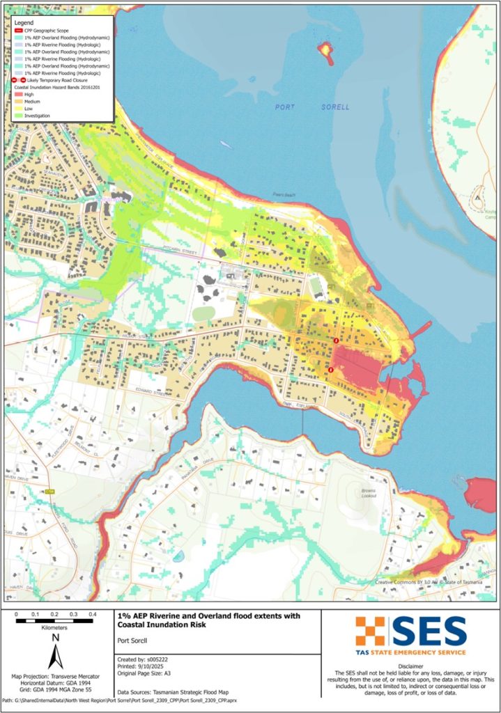
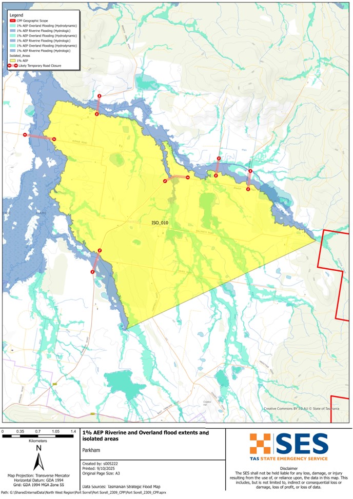
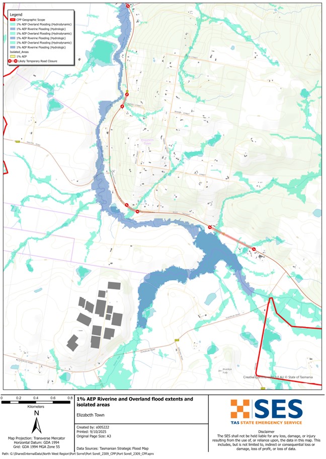
若要更詳細地查看地圖,, 查看塔斯馬尼亞策略性洪水圖.
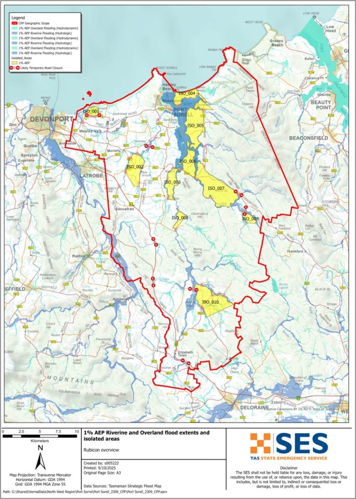
如果盧比孔河發生嚴重洪水,河岸附近的低窪地區可能會被淹沒。洪水有時會中斷道路,例如
- 貝斯公路,伊莉莎白鎮附近
- 索雷尔港路,和
- 像Rice Street和Seabreeze Avenue這樣的本地街道在好幾個地方。.
若當地有強降雨,其他地區也可能因當地水道而發生山洪暴發,例如
- 帕納塔納溪
- 帕度溪,和
- 富蘭克林溪.
在突發性洪水期間,您不能僅依靠河流的洪水警報,只能依靠大雨或惡劣天氣的預報。不尋常的漲潮和風暴也可能增加港口索雷爾水道周圍低窪地區的洪水風險。.
本指南中的地圖顯示了每年有% 機率發生的洪水水位。您在有生之年很可能會經歷地圖所示的洪水。塔斯馬尼亞人需要為不常發生但可能發生的洪水事件,以及他們可能已經經歷過的輕微洪水做好準備。.
即使您的房屋沒有被淹沒,您也應該為與世隔絕以及潛在的電力和電信中斷做好準備。根據降雨地點和強度,該地區的道路可能會無法通行。在道路暢通之前,該地區的交通可能會非常困難甚至不可能。如果您在家中或他處安全,除非有緊急情況,否則通常最好留在原地,直到洪水退去。如果您需要撤離,應及早離開,在洪水來臨前。.
請收聽 ABC 地方電台 91.7FM 獲取警告和建議。.
您有洪水風險嗎?
盧比孔河曾有氾濫的歷史,最近一次的氾濫影響可追溯至 2022 年。.
我應該做什麼?
- 檢查地圖,看看您的住宅或企業是否可能遭受洪水侵襲。.
- 評估您的住家或公司,並做好準備以盡量減少潛在的洪水損害。.
- 檢查您是否能在洪水期間安全地抵達家中、工作地點或學校。.
- 準備一份居家緊急計畫。考慮是否需要在大水來臨前撤離。請參閱 為緊急情況做好準備– 為個人和家庭準備應急措施的指南。.
- If you are a primary producer, the Farm Flood Readiness Kit provides advice on preparing for a flood to help protect your business and stock.
- If you run a business or other organisation, check out the Tasmanian Government’s Emergency Ready Business tool online
- 如果你可能被隔離且必須取得服務,你可能需要提早撤離。.
- 如果你在容易發生洪水的地區露營,請確保隨時掌握最新資訊,並且在可能發生洪水時及早移往高處。.
像地圖所示的洪水,或更糟的洪水,將會再次發生。沒有兩次洪水是相同的。.
如果您居住在低窪地區或靠近水道,您的房屋可能會被淹沒。即使您的住所安全,您也可能需要繞過淹水地區,或者您的道路通行可能會被阻斷。切勿駕車進入或身處洪水之中。道路和橋樑可能會被沖毀或不安全。洪水期間請避免出行。.
知道該怎麼做可以拯救你的生命並保護你的財產。制定家庭緊急計畫是最好的準備方法之一。決定天氣和降雨的觸發條件,以便採取行動。.
中央氣象局預報、警報與觀測
本局發佈 洪水警报、恶劣天气警报和/或雷暴警报,可能因强降雨引发山洪暴发 每當 大雨 可能會在某個區域出現。從發布預警到豪雨發生的時間,可能從一小時到二十四小時不等。.
當預期會有可能導致魯比孔河(Rubicon River)發生洪水時,該局可能會發布洪水預警(Flood Watch),這是一種預報天氣可能引發洪水的「預先提醒」的早期建議。.
SES 與該局不太可能在該區域觀察到洪水影響時發布具體的當地警報。該區域內沒有其他水道的正式預警級別。.
雨量觀測 德罗里恩 (Deloraine) 鐵路橋、金里奇 (Kimberley) 和德文港 (Devonport) 機場以及附近的其他雨量計可以顯示可能的洪水風險。由於預警時間非常短,最好根據氣象局 (BoM) 的預測性警告採取行動,而不是在降雨期間等待任何洪水警報。.
降雨可能在以下閾值開始影響該區域:
-
- 90-145毫米的降雨量在12-24小時內
-
- 160-230毫米的降雨量,持續48-72小時
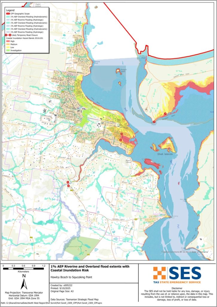
異常高的潮汐也可能導致魯比孔河河口附近斯波特索雷爾水道沿岸低窪沿海地區發生洪水。.
這 西塔戈恩 is useful to be aware in real-time where heavy rainfall is falling. Radar rainfall estimates can also fill in gaps in areas where there are no rainfall stations.
了解警告和關鍵資訊
隨時留意周遭狀況。定期查看天氣預報、觀測數據和警報。.
 |
建議 (黃色): 已發生事件。目前沒有立即危險。請隨時更新最新情況,以防局勢變動。. |
 |
觀察與行動(橘色): 威脅等級升高。情勢正在改變,您現在就必須採取行動保護您和您的家人。 |
 |
緊急警告(紅色): 緊急警報為最高級別的警報。您可能身處危險之中,需要立即採取行動。任何延誤都可能危及您的生命。. |
 |
社群更新(藍色): 針對特定事件或事故,向受影響社群提供的具體資訊和最新消息。. |
| 事件(白色): 事件是緊急警報發布前的初步發生。一旦事件被報告,TasALERT 就會發布基本資訊,包括事件的類型和地點。. |
洪水水位
雖然沒有兩次洪水是完全相同的,但以下描述了該地區在不同洪水水位下可能發生的情況。即使您的房產沒有被淹沒,您也需要考慮進出問題。不同程度的降雨都會導致洪水,這取決於降雨的強度、持續時間,以及事先的土壤濕度以及降雨發生的地點。.
輕度至中度洪水
小範圍淹水
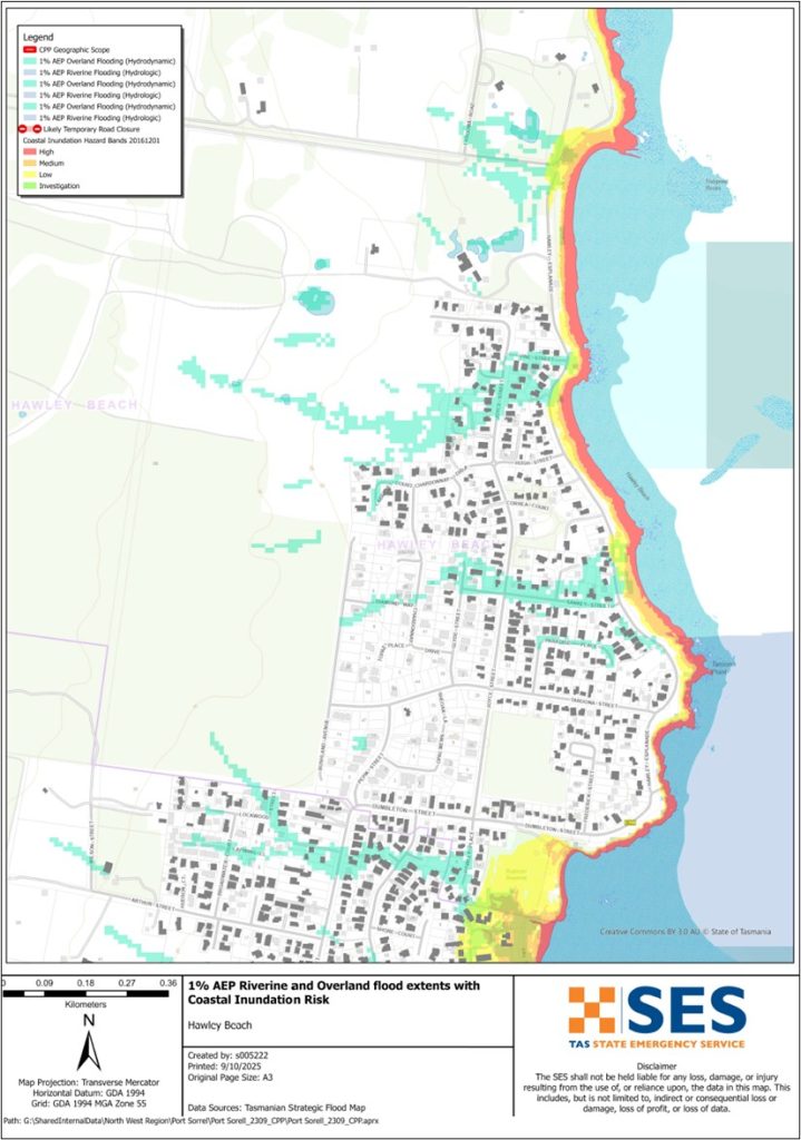
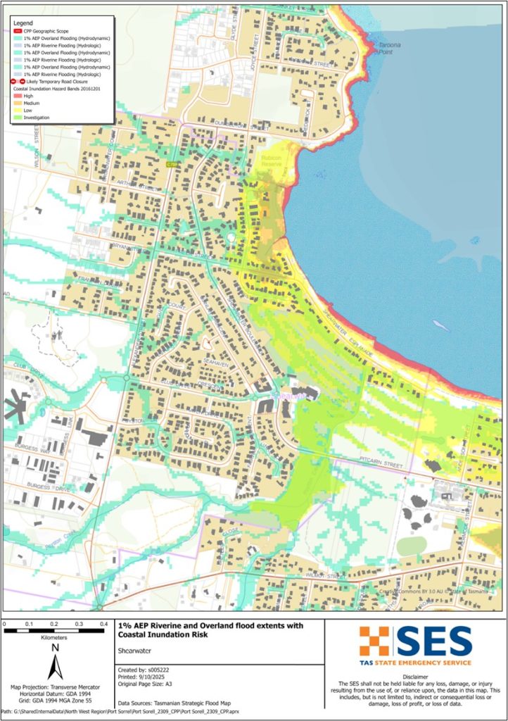
A minor flood can inundate low lying paddocks, orchards and other farmland. Stock should be moved for their safety. There may also be some flooding across some minor roads and parkland areas. Areas close to the shoreline may see some higher levels of flooding during higher tides.
中度洪水
農業用地淹水範圍擴大,部分建築物可能受到影響(淹水高度超出樓地板)。由於部分次要道路淹水,部分房產可能在數小時內與外界隔離。例如,部分房產可能出現淹水情況:
-
- 港索羅爾
-
- 海潮巷、海馬巷和稻米街。.
-
- 斯nrows港房車公園可能開始氾濫
-
- 霍利海灘
-
- 桑基街
-
- 霍利街.
嚴重洪水
If there is major flooding along the Rubicon River and other waterways, there may be flooding in low-lying areas close to the river. That level of flooding is approximately the level of the 2011, 2016 and 2022 floods and there is about a 5% chance of such a flood happening any year. Tasmanians need to be prepared for floods that have a 1% chance of happening every year.
根據降雨的位置和土壤飽和程度,這種程度的洪水可能會:
-
- 淹沒魯比肯河附近低窪地區的房產,例如位於索羅爾港(Port Sorell)和希爾瓦特(Shearwater)的地區。.
-
- 關閉該地區的幾條道路,包括巴斯公路、索雷爾港公路及其他地方道路,以隔離周邊房產。
-
- 隔離貝克烘焙師海灘區、納拉旺塔普國家公園、哈福德和弗蘭克福德的社區的幾個部分。
-
- 洪水會影響德文港機場的運作。.
Go to TasALERT.com or listen to ABC local radio for detailed up to date information and advice during heavy rainfall events.
了解你的風險,做好準備,盡可能降低風險,與他人聯繫,保持警惕並安全行動。.
洪水之前
為緊急情況做好準備 – 為個人和家庭準備應急措施的指南。.
1. 認識你的風險
塔斯馬尼亞經常發生洪水,可能造成廣泛且嚴重的損害。在過去 200 年裡,塔斯馬尼亞有 78 人死於與洪水相關的事件。本指南旨在幫助您了解您所在地區的洪水風險。.
2. 準備您的家戶
制定包含風暴和洪水應變計畫
思考一下在風暴或洪水來襲時你會怎麼做,意味著你準備得更充分,每個人都會更安全。制定一個家庭中的每個人都理解的緊急計畫。有檢查表可以幫助你思考你的計畫——請參閱 為緊急情況做好準備 – 為個人和家庭準備應急措施的指南。.
定期檢查您的計劃,並讓家中的每個人都設想一次可能影響您家的洪水情況來進行測試。.
準備一個緊急救生包
準備好了
- 電池供電的收音機和手電筒,備用電池
- 重要資訊,例如您的緊急應變計畫
- 緊急電話號碼列表
- 食物和水
- 急救箱
- 橡膠手套或堅固的皮革手套
需要時打包
- 暖和的衣服、結實的鞋子或靴子
- 藥品、眼鏡或其他必需品
- 手機和充電器
- 寵物食品和他們需要的任何其他東西
- 照片和特別紀念品
- 錢
- 重要文件,例如
-
- 保險文件
-
- 護照與
-
- 出生證明
定期測試收音機和手電筒的電池。.
3. 在可能的情況下,降低您遭受洪水侵襲的風險
- 在購買、維護或開發房地產時,請考慮風暴、洪水和其他災害。.
- 修剪或移除您家中、商家或您家附近有電力線的樹木和樹枝。.
- 保持您的排水溝和排水管暢通。.
4. 與他人建立聯繫
Know your neighbours and get involved in your community. A connected community is a safer and more resilient community in an emergency and can help everyone recover better afterwards. Check that family and neighbours are safe and aware of what’s happening.
期間
5. 保持更新
隨時留意周遭狀況。定期查看天氣預報、觀測數據和警報。.
- 這 氣象局 網站.
6. 保持安全
- 監督兒童.
- 為可能的停電、停水或斷網做好準備。.
- 檢查您的緊急救助包是否已準備就緒。.
- 切勿靠近淹水區域,例如排水溝。. 永不 在洪水中有行走、玩耍、骑行或开车。你無法確定水下有什麼,或水有多深、流速有多快。20公分的湍急的洪水就很容易將人沖走並淹死。洪水可能很危險。.
您的房屋可能發生淹水時
- 將家居物品放在高處,以盡量減少潛在損壞。.
- 如果安全的話,請關閉水電和瓦斯。.
- 一種防止污水倒灌回屋內的好方法是將沙包放入塑膠袋中,然後用它們來堵塞馬桶、蓋住排水孔和水槽。.
- 趁你還能安全脫困時趕快離開。.
如果你需要疏散
- 請遵循 SES / 塔斯馬尼亞警方的建議。.
- 帶上你的緊急求生包。.
- 前往朋友或家人較安全的地方,或前往疏散中心。.
- 讓別人知道你去了哪裡。.
照顧好你的動物
You are responsible for your animals in an emergency. If you have pets and other animals it will take you longer to evacuate in a flood or other emergency. Move livestock from flood prone areas well before flood waters may rise. For more information see
請避免在風暴期間和風暴之後旅行
- 不要去觀光。觀光客會延誤緊急服務並造成事故。.
- 注意危險,例如
-
- 路面积水
-
- 損壞的電力線
-
- 山崩
-
- 損壞的道路
-
- 倒下的樹木或屋頂鐵片。.
- 切勿駕車通過淹水區域。洪水中的大多數死亡和救援事件都與駕車通過淹水區域有關。.
- 緩慢行駛,並在不受洪水影響的道路上打開頭燈。.
之後
- 請持續收聽 ABC 地方電台的最新消息、道路重新開放、社區會議等資訊。.
- 如果您離開家,請勿在聯邦緊急事務局 (SES) 或塔斯馬尼亞警方告知您安全之前回家。.
- 注意道路上的危險,例如路面上的泥沙或碎屑、道路/橋樑損壞以及正在進行清理和修復工作的工人。.
如果您的房屋已受損
- 在檢查損壞時,請待在地面。小心掉落的樹木、碎玻璃、鬆動的屋頂或其它危險物品。.
- 穿著堅固的靴子、手套和防護服。.
- 請使用手電筒,切勿在受洪水影響的建築物內使用火柴或蠟燭。.
- 將所有飲用水煮沸,直到被告知自來水再次安全為止。.
- Do not turn on it is tested by a licensed electrician or gas fitter for safety.
- 如果您的房屋受損,需要暫時住在其他地方,請攜帶您的緊急應變包和寵物一同前往。
- 如安全,請拍攝任何損壞的照片,並聯繫您的保險公司。.
- 監督兒童.
- 檢查鄰居是否安好。.
如需更多資訊,請前往 www.ses.tas.gov.au
保持獲取最新資訊及更多詳盡資料
Current warnings – TasALERT.com
Emergency Broadcasters – 您當地的 ABC 電台
TASSES Social Media – facebook.com/sestasmania
為洪水緊急情況做準備 ses.tas.gov.au/flood-plan/
國家轉接服務 (NRS) relayservice.gov.au
Local Emergency Broadcasters ABC 103.3 FM
Latrobe Council latrobe.tas.gov.au 6426 4444
Meander Valley Council meander.tas.gov.au 6393 5300
免責聲明
The maps show potential flooding risks from consistent levels of rainfall across catchments, such as a 1% Annual Exceedance Probability (AEP). In flooding events, rainfall is likely to be more inconsistent across a catchment, so these flood maps should be considered indicative only. The mapped areas of flood risk show higher probability of inundation. Other areas have lower probability of flooding, but in severe and rare events (rarer than 1%AEP), other lower areas may be also at risk of inundation.
本指南中的資訊在出版時是最新資料。儘管已盡一切努力確保所呈現數據的有效性和準確性,但州緊急服務部門不對數據錯誤或遺漏負責。請參閱標準 塔斯馬尼亞州政府的版權與免責聲明 更多詳情.
