Hướng dẫn lũ lụt khu vực không có đê chắn Launceston
Thông tin về lũ lụt sông và lũ quét cho các cộng đồng và tài sản ở Launceston bên ngoài các khu vực được bảo vệ bởi đê
Đối với các khu vực được bảo vệ bởi đê, hãy xem hướng dẫn lũ lụt liên quan cho
- Newstead
- Invermay
- Đông Launceston và Khu trung tâm thương mại Launceston, và
- Launceston – Khu vực Phố Margaret.
Version 1.1 April 2026 – see the PDF version
Hướng dẫn này dành cho những người dân ở các khu vực Launceston không được đê bao bảo vệ. Ngay cả khi nhà bạn không bị ngập, mọi người xung quanh Launceston sẽ bị ảnh hưởng bởi một trận lụt lớn trong thành phố. Hướng dẫn này cũng bao gồm lũ nhỏ, lũ vừa và lũ quét ở tất cả các khu vực của thành phố.
Các khu vực của Launceston có thể bị lũ lụt từ
- Nơi gặp nhau của sông Tamar
- Sông North Esk
- Sông South Esk.
Cũng có một số tuyến đường thủy nhỏ có thể gây ngập lụt các tài sản và đường sá.
Các khu vực được bảo vệ đê Launceston
Các bờ kè Launceston giúp giảm thiểu nguy cơ lũ lụt cho nhiều khu vực dọc theo các con sông lớn. Tuy nhiên, không có gì đảm bảo rằng các bờ kè sẽ trụ vững trước một trận lũ lớn. Kinh nghiệm ở các quốc gia khác cho thấy các bờ kè có thể bị sụp đổ, cả dần dần lẫn đột ngột. Nếu các bờ kè bị sụp đổ, các khu vực trũng thấp của thành phố có thể bị ngập lụt nhanh chóng. Trong các trận lũ lớn, người dân ở các khu vực được bảo vệ bởi bờ kè nên sơ tán trong trường hợp
- đê vỡ, hoặc
- nước lũ tràn qua đê.
Vui lòng xem các hướng dẫn về lũ lụt liên quan cho các khu vực được đê bảo vệ của
- Newstead
- Invermay
- Đông Launceston và Khu trung tâm thương mại Launceston, và
- Launceston – Khu vực Phố Margaret.
Những hướng dẫn này cho các khu vực được đê bảo vệ chứa thông tin quan trọng về
- Các yếu tố kích hoạt sơ tán trong các trận lũ lớn
- cách sơ tán, bao gồm các tuyến đường sơ tán cần sử dụng.
Nếu sông Esk phía Bắc và/hoặc phía Nam có thể đạt đến các mực nước nhất định, các khu vực này sẽ có:
- Một thông báo sơ tán tự nguyện – nơi mọi người được khuyên nên rời đi để đảm bảo an toàn
- Một cảnh báo sơ tán bắt buộc – nơi mọi người nên rời khỏi những khu vực đó để đảm bảo an toàn, và để ngành điện, khí đốt và nước có thể cắt dịch vụ cho những khu vực đó.
- Trong các trận lũ lớn, mọi người bên ngoài các khu vực dễ bị lũ lụt cần lưu ý rằng
- Các tuyến đường giao thông chính qua thành phố có thể bị cắt
- Giao thông có thể sẽ rất đông đúc
- Có thể sẽ có những cắt giảm đối với một số dịch vụ thiết yếu, chẳng hạn như xử lý nước.
- Có thể sẽ có những cắt giảm đối với một số dịch vụ khác khi các tuyến giao thông chính bị cắt giảm.
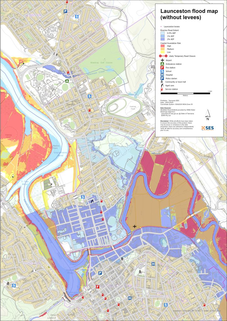
Các khu vực có thể bị ngập lụt bên ngoài các khu vực được đê bảo vệ
Sông có thể gây lũ lụt ở một số khu vực bên ngoài các khu vực được đê bảo vệ. Triều cường cũng có thể làm tăng mực nước ở các khu vực gần sông Tamar hơn.
For more detailed flood maps, see www.launceston.tas.gov.au/Emergency-Management-Hub/1.-Understand-your-risk/Flood đến
- Kiểm tra Bản đồ Lũ lụt Launceston để đánh giá mức độ rủi ro lũ lụt do sông của bạn.
- Kiểm tra Bản đồ lũ lụt đô thị (nước mưa) cho các bản đồ lũ lụt nước mưa lũ quét.
- Tìm hiểu thêm về các đê chắn lũ của Launceston.
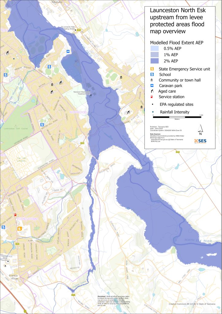
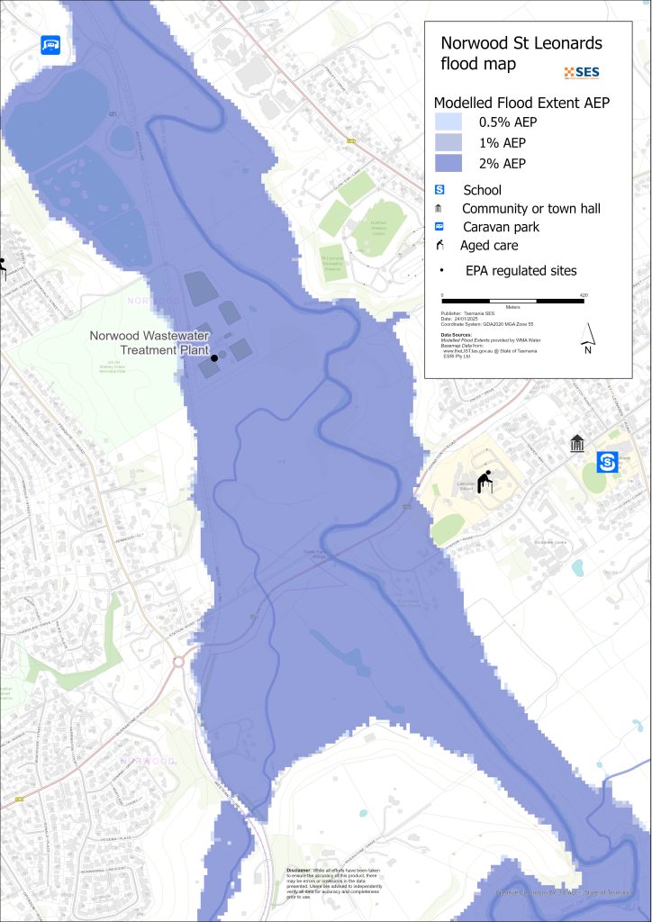
Khu vực thấp xung quanh sông North Esk
- Khu cắm trại Hướng đạo sinh Corra Linn, Đảo Patersons và các ao cá lịch sử gần đó cùng một số ngôi nhà
- St Leonards xung quanh
- Đường Ga
- Đường Hoblers Bridge
- Đường Waverley
- Đường Ravenswood
- Các khu vực Norwood và Newstead ngoài khu vực được bảo vệ bởi đê, bao gồm cả khu cắm trại trên Đường Sandown (Trang trại Old Mac)
- Waverley – Đường Boomer
Vùng đất thấp xung quanh sông South Esk và sông Tamar
- Khu bảo tồn Hẻm núi Cataract – Bể bơi Thứ nhất
- Khu cảng biển
- Khu Kings Wharf
- Khu vực Xa lộ West Tamar
Các khu vực trũng thấp khác có nguy cơ lũ quét/lũ diện rộng
Lũ quét là trận lũ xảy ra rất nhanh sau khi có mưa lớn. Thường có rất ít cảnh báo, ngoại trừ cảnh báo thời tiết khắc nghiệt chung. Có nhiều tuyến đường thủy nhỏ xung quanh Launceston có thể bị ngập lụt nhanh chóng. Các khu vực trũng thấp có thể bị ngập lụt do lũ quét hoặc nước chảy trên bộ bao gồm các khu vực
- Relbia gần suối Jinglers
- Kingsmeadows/ Punchbowl
- Newnham – do lũ quét từ suối Newnham và Barnards
- South Launceston
- Waverley
- Phố Faraday từ Suối Chưng cất
- Đường Ravenswood từ Distillery Creek/Sông North Esk.
Nếu có mưa rất to, có thể có dòng chảy nước mưa mạnh ảnh hưởng đến các tòa nhà và đường sá ở bất kỳ khu vực nào.
Các khu vực xung quanh Launceston
Để biết thông tin về lũ lụt ở các khu vực xung quanh, hãy xem các hướng dẫn liên quan gần đó về:
- Lilydale và các vùng lân cận
- Nunamara and surrounds – currently under development
- Hadspen/Blackstone Heights
Bạn có nguy cơ bị lũ lụt không?
Khu vực Launceston có lịch sử lũ lụt lâu đời. Kể từ khi người châu Âu đến định cư
- Năm 1852, 1863 và 1893 đã ghi nhận các trận lũ lụt nghiêm trọng ở Launceston.
- Năm 1929 là trận lũ lụt tồi tệ nhất được ghi nhận trong lịch sử hiện đại. Hơn một nghìn ngôi nhà và tòa nhà bị hư hại, một số bị cuốn trôi khỏi móng. Hai cây cầu treo bắc qua khu vực Hẻm núi đã bị hư hại. Bốn nghìn người đã được sơ tán khỏi các khu vực Invermay, Inveresk và Margaret Street. Mãi đến năm 1940, Launceston mới phục hồi sau trận lụt. Trận lụt năm 1929 là động lực để xây dựng đê điều.
- Năm 2016 – Thành phố Launceston đã chuẩn bị đối phó với một đợt lũ lụt quy mô lớn và đóng cửa một số đê. Các đợt nâng cấp hệ thống đê trước đó đã giúp tránh được thiệt hại ước tính khoảng 1.421,6 triệu đô la, nếu như các đê cũ kỹ trước đây bị vỡ.
- 2022 – Launceston suýt phải đối mặt với trận lụt lớn.
Dự báo, cảnh báo và quan sát của Cục Khí tượng (BoM)
BoM phát hành một Theo dõi lũ lụt khi thời tiết dự báo có thể gây lũ lụt trong khu vực. Một Thông báo lũ lụt có thể:
- dành cho một khu vực cụ thể như là Sông South Esk lưu vực, chẳng hạn như, hoặc
- có thể được khái quát hóa như đối với Lưu vực sông Trung Bộ
Vấn đề BoM Cảnh báo lũ lụt với mực nước lũ cụ thể cho các sông South Esk và North Esk. Các thước đo lũ dọc theo các con sông cảnh báo về
- chiều cao lũ, và
- những tác động có thể xảy ra ở Launceston.
Triều cường cũng có thể làm gia tăng tình trạng ngập lụt.
Cục sẽ ban hành cảnh báo lũ nhỏ, lũ vừa hoặc lũ lớn khi sông North Esk hoặc sông South Esk có khả năng đạt đến các mực nước nhất định. Bảng dưới đây cũng cho thấy các ngưỡng kích hoạt để SES ban hành cảnh báo sơ tán do lũ lụt từ các con sông này.
| Trạm đo lưu lượng sông | Nhỏ | Trung bình | Lũ lớn | Các điểm quyết định quan trọng khi sơ tán |
| Sông North Esk tại Corra Linn |
2,7 mAHd 80 m³/giây |
3.6 mAHD 200 m³/giây |
4.9 mAHD 419 m³/giây Khoảng 20% AEP |
6,1 mAHD 800 m³/giây Giới thiệu về 2% AEP Khu vực được Bảo vệ Đê chắn Newstead (LPA) |
| Sông South Esk @ Hồ Trevallyn |
128,2 mm khoảng 420 m³/giây > 20% AEP |
129,9 mdAr khoảng. 1500 m³/giây Approx. 10%AEP |
130,9 mAHD khoảng. 2.000 m³/s Khoảng 5% AEP |
2250 m³/giây Từ 21 giờ 3 phút đến 11 giờ 3 phút AEP Khu vực được bảo vệ đê Invermay / Inveresk |
|
2.500 m³/s – Trong khoảng <1% AEP Thành phố / Khu vực được bảo vệ bởi Đê Đông Launceston |
||||
|
3.500 m³/s – Trong khoảng >1% AEP Khu vực được bảo vệ đê Margaret Street |
Ghi chú:
- m³/s (cumec) – một mét khối nước chảy qua một điểm trong một giây. Một mét khối nước bằng một nghìn lít và nặng một tấn.
- Annual Exceedance Probability (%AEP) is the likelihood of such an event happening any given year, based on historical records up to 2016. With climate change, this likelihood is changing. Updates of this data is underway.
- mAHD – Mét trên đại cao. Đây là độ cao cục bộ cho địa điểm đo.
Tôi nên làm gì?
-
- Kiểm tra bản đồ để xem nhà hoặc cơ sở kinh doanh của bạn có thể bị ngập lụt hay không.
-
- Đánh giá ngôi nhà hoặc doanh nghiệp của bạn và chuẩn bị để giảm thiểu thiệt hại do lũ lụt có thể xảy ra.
-
- Kiểm tra xem bạn có thể đến nhà, nơi làm việc hoặc trường học một cách an toàn trong lũ lụt hay không.
-
- Chuẩn bị Kế hoạch Khẩn cấp Tại nhà. Cân nhắc xem bạn có cần sơ tán trước khi lũ lụt xảy ra không. Xem Chuẩn bị cho trường hợp khẩn cấp– Hướng dẫn chuẩn bị khi có tình huống khẩn cấp cho cá nhân và hộ gia đình.
-
- Nếu bạn là một nhà sản xuất chính, Bộ dụng cụ sẵn sàng ứng phó với lũ lụt cho trang trại cung cấp lời khuyên về việc chuẩn bị đối phó với lũ lụt để giúp bảo vệ doanh nghiệp và hàng hóa của bạn.
-
- If you run a business or other organisation, check out the Tasmanian Government’s Emergency Ready Business tool online
-
- Nếu bạn có thể bị cô lập và phải tiếp cận các dịch vụ, bạn có thể cần phải sơ tán sớm.
-
- Nếu bạn cắm trại ở khu vực dễ bị lũ lụt, hãy đảm bảo bạn cập nhật thông tin và di chuyển đến vùng đất cao hơn sớm nếu có khả năng xảy ra lũ lụt.
Lũ lụt như trận lụt được hiển thị trên bản đồ, hoặc tệ hơn, sẽ xảy ra một lần nữa. Không có hai trận lũ nào giống nhau.
Nếu bạn sống ở vùng trũng thấp hoặc gần bờ sông, nhà bạn có thể bị ngập lụt. Ngay cả khi nhà bạn an toàn, bạn có thể phải đi đường vòng tránh các khu vực bị ngập lụt hoặc lối vào nhà bạn có thể bị cắt. Tuyệt đối không lái xe vào hoặc đi vào vùng nước lũ. Đường sá và cầu cống có thể bị cuốn trôi hoặc không an toàn. Tránh di chuyển trong lũ.
Biết cách xử lý có thể cứu mạng bạn và giúp bảo vệ tài sản của bạn. Lập Kế hoạch Ứng phó Khẩn cấp cho Gia đình là một trong những cách chuẩn bị tốt nhất. Quyết định các yếu tố thời tiết và lượng mưa sẽ ra tín hiệu hành động.
Dự báo, cảnh báo và quan sát của Cục Khí tượng (BoM)
BoM phát hành một Theo dõi lũ lụt khi thời tiết dự báo có thể gây lũ lụt trong khu vực. Một Thông báo lũ lụt có thể:
- dành cho một khu vực cụ thể như là Sông South Esk lưu vực, chẳng hạn như, hoặc
- có thể được khái quát hóa như đối với Lưu vực sông Trung Bộ
Vấn đề BoM Cảnh báo lũ lụt with specific flood heights for the South Esk and North Esk Rivers. Flood gauges along the rivers give warnings of
- chiều cao lũ, và
- những tác động có thể xảy ra ở Launceston.
Triều cường cũng có thể làm gia tăng tình trạng ngập lụt.
The Bureau will issue Minor, Moderate or Major flood warnings when the North Esk or South Esk Rivers are likely to reach certain heights. The table below also shows the trigger levels for SES to issue evacuation warnings due to flooding from these rivers.
| Trạm đo lưu lượng sông | Nhỏ | Trung bình | Lũ lớn | Các điểm quyết định quan trọng khi sơ tán |
| Sông North Esk tại Corra Linn | 2,7 mAHd
80 m³/giây |
3.6 mAHD
200 m³/giây |
4.9 mAHD
419 m³/giây Khoảng 20% AEP |
6,1 mAHD
800 m³/giây Giới thiệu về 2% AEP Khu vực được Bảo vệ Đê chắn Newstead (LPA) |
| Sông South Esk @ Hồ Trevallyn | 128,2 mm khoảng 420 m³/giây
> 20% AEP |
129,9 mdAr khoảng.
1500 m³/giây Approx. 10%AEP |
130,9 mAHD khoảng.
2.000 m³/s Khoảng 5% AEP |
2250 m³/giây
Từ 21 giờ 3 phút đến 11 giờ 3 phút AEP Khu vực được bảo vệ đê Invermay / Inveresk |
| 2.500 m³/s – Trong khoảng <1% AEP
Thành phố / Khu vực được bảo vệ bởi Đê Đông Launceston |
||||
| 3.500 m³/s – Trong khoảng >1% AEP
Khu vực được bảo vệ đê Margaret Street |
Ghi chú:
- m³/s (cumec) – một mét khối nước chảy qua một điểm trong một giây. Một mét khối nước bằng một nghìn lít và nặng một tấn.
- Annual Exceedance Probability (%AEP) is the likelihood of such an event happening any given year, based on historical records up to 2016. With climate change, this likelihood is changing. Updates of this data is underway.
- mAHD – Mét trên đại cao. Đây là độ cao cục bộ cho địa điểm đo.
Hiểu các cảnh báo và thông tin chính
Luôn cảnh giác với những gì đang xảy ra xung quanh bạn. Thường xuyên kiểm tra dự báo, quan sát và cảnh báo.
 |
Lời khuyên (Màu vàng): Một sự cố đã xảy ra. Không có nguy hiểm tức thời. Hãy cập nhật thông tin trong trường hợp tình hình thay đổi. |
 |
Xem và hành động (Cam): Mức độ đe dọa đã tăng cao. Tình hình đang thay đổi và bạn cần phải hành động ngay bây giờ để bảo vệ bản thân và gia đình. |
 |
Cảnh báo khẩn cấp (Đỏ): Cảnh báo Khẩn cấp là cấp độ cảnh báo cao nhất. Bạn có thể đang gặp nguy hiểm và cần hành động ngay lập tức. Bất kỳ sự chậm trễ nào bây giờ đều có thể gây nguy hiểm đến tính mạng của bạn. |
 |
Cập nhật cộng đồng (Xanh lam): Thông tin và cập nhật cụ thể cho các cộng đồng bị ảnh hưởng về một sự kiện hoặc sự cố cụ thể. |
| Sự cố (Trắng): Sự cố là lần xảy ra đầu tiên của một sự kiện trước khi nó trở thành cảnh báo khẩn cấp. Ngay khi một sự cố được báo cáo, TasALERT sẽ công bố thông tin cơ bản bao gồm loại và vị trí của sự cố. |
Mực nước lũ
Mặc dù không có trận lũ nào giống trận nào, nhưng những điều sau đây mô tả những gì bạn có thể mong đợi ở các mức độ lũ khác nhau trong khu vực. Ngay cả khi tài sản của bạn không bị ngập lụt, bạn vẫn cần suy nghĩ về khả năng tiếp cận. Các mức độ mưa khác nhau có thể gây ra lũ lụt tùy thuộc vào cường độ, thời gian và độ ẩm của đất trước đó cũng như nơi mưa rơi.
Lũ lụt nhỏ trên sông Bắc Esk/Nam Esk và Sông Tamar
North Esk tại Corra Linn ít nhất 2,7m
- Đất nông nghiệp/công viên ven sông, ví dụ, khu dã ngoại St Leonards
- Có thể đóng cửa đường – Phố Henry
- Các tài sản đất thấp gần sông tại:
- Đường Ga
- Đường Henry
- Phố Killafaddy
- Khu cắm trại Old Mac’s Farm trên đường Sandown
- Tuyến đường sắt phía Tây và các bãi đậu tàu
- Scotch Oakburn Park và Queechy Park
- South Esk tại hồ Trevallyn ít nhất 128,2m
- Đất nông nghiệp/ khu công viên ven sông, ví dụ: Khu bảo tồn Cataract Gorge và Hồ bơi Gorge, khu vực xung quanh Home Point Parade
- Bến cảng Kings
- Khu vực trũng thấp của Cựu Cảng, Điểm Diễu Hành
- Câu lạc bộ chèo thuyền West Tamar
- Khu vực Phố Henry
- Nước lũ có thể bắt đầu ảnh hưởng đến làn đường hướng nam của Xa lộ West Tamar, với giao thông sẽ được chuyển hướng sang các tuyến đường thay thế.
Lũ lụt vừa phải từ sông North Esk/ South Esk và sông Tamar
- Nhiều cửa xả lũ của đê sẽ đóng lại, hạn chế việc di chuyển qua thành phố. Các tuyến đường chính sẽ bị đóng cửa qua sông bao gồm:
- Đường West Tamar
- Đường Henry
North Esk tại Corra Linn ít nhất 3,6m
Theo tình hình ngập lụt nhỏ, cộng thêm
- Đường Station Road và các khu đất trũng hơn gần sông
- Henry Street và các khu vực lân cận và các khu đất thấp
- Sân/ xưởng Scotch Oakburn College
- Cầu Hoblers và Trung tâm Bóng chuyền
- Bất động sản thấp tầng trên đường Killafaddy
- Các bất động sản nằm ở vùng đất thấp trên đường Glenwood
- Đường Bill Grove, Mowbray.
- Sông South Esk tại Hồ Trevallyn, cao ít nhất 129,9m
- Theo lũ lụt nhỏ cộng với
- Đường West Tamar Highway, cả hai chiều, được chuyển hướng qua các đường phụ.
- Đại lộ Cảng
- Sẽ có một số ảnh hưởng xung quanh Phố Henry và các khu vực khác ở Hạ lưu sông North Esk.
- 1600 m3/s @ Hồ Trevallyn – sơ tán tự nguyện khu vực Invermay (xem Hướng dẫn lũ lụt Invermay)
- Đường Bill Grove, Mowbray.
Lũ lụt lớn trên sông từ các sông North Esk/ South Esk và sông Tamar
Mực nước sông North Esk tại Corra Linn ít nhất 4,9 m (khoảng 20% AEP)
Theo mực nước lũ vừa phải, cộng thêm:
- Đê chắn lũ Hart St đóng cửa, một phần đê Invermay đóng cửa
- Cửa xả lũ khu vực đường ray đã đóng
- Lối qua sông South Esk Đường Blessington
- Các thuộc tính khác trên Đường Station
- Khuôn viên trường Larmenier gần sông
- Nhiều trạm bơm nước thải có thể bị ảnh hưởng
- Đường Johnson/ Đường Station
- 800 m3/s @ Corra Linn- Newstead – Hart St area mandatory evacuation (Approx 2%AEP)
- Sông South Esk tại ao Trevallyn ít nhất 130m (2000 m³/s)
- Theo lũ lụt vừa phải cộng với
- 2250 m³/s – Sơ tán bắt buộc Invermay – xem hướng dẫn lũ lụt Invermay
- 2500 m³/s – Đê Invermay có thể tràn. Di tản bắt buộc các khu vực trung tâm thành phố Launceston – xem hướng dẫn lũ lụt cho Launceston và khu vực East Launceston/ Launceston – Margaret Street,
- Các khu vực của Seaport, Kings Wharf bị ngập lụt
- Other areas – flash flooding from minor waterways (1-2%AEP)
- Lũ quét từ các sông suối nhỏ có thể xảy ra nhanh chóng, với rất ít cảnh báo cụ thể. Các khu vực có nguy cơ bao gồm
- Cầu Relbia Road và một số khu dân cư thấp ven
- Đường Relbia
- Tòa nhà Redwood Crescent
- Đường Oppossum
- Đường Glenwood.
- Kings Meadows gần Kings Meadows Rivulet, bao gồm Đường Hobart
- Các khu vực trũng thấp ở South Launceston gần Đường Margaret/Đường Bathurst, bao gồm Đường Midland gần giao lộ Đường Wellington và các bất động sản trũng thấp lân cận
- Các tuyến đường và bất động sản trũng thấp ở Newstead, đặc biệt là gần Phố Robin
- Đường xá và các bất động sản ở East Launceston quanh phố Dowling.
- Newnham, đường Lilydale và tuyến đường sắt Bell Bay tại giao lộ Barnards Creek, cộng thêm một số tài sản.
Các bản đồ trong hướng dẫn này thể hiện mức độ ngập lụt có xác suất xảy ra là 1% trong bất kỳ năm nào, bao gồm cả trường hợp các đê điều bảo vệ một số khu vực, cũng như trường hợp đê điều bị vỡ hoặc bị nước tràn qua. Các bản đồ này không thể hiện dòng chảy trên mặt đất/nước mưa chảy tràn. Trừ khi có một cơn bão mạnh kèm theo mưa rất lớn, các nguy cơ ngập lụt chính đối với Launceston chủ yếu đến từ các con sông lớn của thành phố.
Hai hệ thống sông chính của Launceston có thể bị lũ lụt cùng lúc và có thể có mức độ lũ lụt khác nhau trong cùng một sự kiện. Sông kanamaluka/River Tamar chịu ảnh hưởng của thủy triều và cũng có thể ảnh hưởng đến chiều cao lũ lụt.
Bạn có thể sẽ trải qua lũ lụt như những gì được thể hiện trên bản đồ trong đời. Người dân Tasmania cần chuẩn bị cho các trận lũ có thể không xảy ra thường xuyên cũng như lũ lụt nhỏ mà họ có thể đã từng trải qua.
Trong một sự kiện lũ lụt lớn, các cửa cống bị đóng và đường sá bị ngập có thể cắt đôi thành phố Launceston cho đến khi nước rút dần:
- Khu Trung tâm Thương mại và các khu vực phía nam trung tâm thành phố
- Các khu vực phía Bắc và Đông Bắc của Sông North Esk/Tamar
- Khu vực Trevallyn/ Riverside về phía Tây và Tây Bắc của Sông Tamar
Tùy thuộc vào lượng mưa ở các khu vực xung quanh, có thể có các tuyến đường thay thế. Tuy nhiên, giao thông có thể sẽ rất ùn tắc.
Ngay cả khi nhà bạn không bị ngập lụt, bạn cũng nên chuẩn bị cho
- các tuyến giao thông chính xuyên qua thành phố sẽ bị cắt, và
- Các khả năng mất điện và gián đoạn viễn thông.
Nếu một số khu vực có lệnh sơ tán bắt buộc đối với các khu vực được bảo vệ bởi đê, điện, nước và gas sẽ bị ngắt để
- giảm thiểu rủi ro, và
- bảo vệ tài sản để chúng có thể được khôi phục sớm nhất có thể sau sự kiện.
Việc đi lại trong khu vực có thể khó khăn hoặc không thể cho đến khi
- đường sá thông thoáng, và
- Cửa cống được mở lại.
Nếu bạn đang an toàn tại nhà hoặc ở nơi khác, tốt nhất bạn nên ở yên đó cho đến khi lũ rút, trừ khi có trường hợp khẩn cấp. Nếu bạn cần sơ tán, bạn nên rời đi sớm, trước khi nước lũ dâng cao.
Go to TasALERT.com or listen to ABC local radio for detailed up to date information and advice during heavy rainfall events.
Biết rủi ro của bạn, chuẩn bị sẵn sàng, giảm thiểu rủi ro nếu có thể, kết nối với người khác, luôn cảnh giác và hành động an toàn.
Trước trận lũ lụt
Chuẩn bị cho trường hợp khẩn cấp – Hướng dẫn chuẩn bị khi có tình huống khẩn cấp cho cá nhân và hộ gia đình.
1. Biết rủi ro của bạn
Lũ lụt thường xuyên xảy ra ở Tasmania và có thể gây thiệt hại trên diện rộng và nghiêm trọng. Trong 200 năm qua, đã có 78 người chết vì lũ lụt ở Tasmania. Hướng dẫn này nhằm giúp bạn hiểu rõ rủi ro lũ lụt trong khu vực của mình.
2. Chuẩn bị cho gia đình bạn
Có kế hoạch khẩn cấp phòng chống bão và lũ lụt
Chuẩn bị cho bản thân và gia đình khi có bão lũ sẽ giúp mọi người an toàn hơn. Hãy lập một kế hoạch ứng phó khẩn cấp mà mọi thành viên trong gia đình đều hiểu. Có những danh sách kiểm tra để giúp bạn lên kế hoạch – xem Chuẩn bị cho trường hợp khẩn cấp – Hướng dẫn chuẩn bị khi có tình huống khẩn cấp cho cá nhân và hộ gia đình.
Thường xuyên kiểm tra kế hoạch của bạn và mọi người trong gia đình hãy cùng nhau xem xét một kịch bản lũ lụt có thể ảnh hưởng đến gia đình bạn.
Chuẩn bị Bộ Dụng Cụ Khẩn Cấp
Sẵn sàng lên đường
-
- Radio và đèn pin chạy bằng pin, pin dự phòng
-
- Thông tin quan trọng, chẳng hạn như kế hoạch khẩn cấp của bạn
-
- Danh sách các số điện thoại khẩn cấp
-
- Thức ăn và nước uống
-
- Bộ sơ cứu
-
- Găng tay cao su hoặc găng tay da dày
Đóng gói khi cần
-
- Quần áo ấm, giày chắc chắn hoặc ủng
-
- Thuốc, kính hoặc các vật dụng thiết yếu khác
-
- Điện thoại di động và sạc điện thoại
-
- Thức ăn cho thú cưng và bất cứ thứ gì khác chúng cần
-
- Ảnh và những kỷ vật đặc biệt
-
- Tiền
-
- Tài liệu quan trọng, ví dụ
-
- giấy tờ bảo hiểm
-
- hộ chiếu và
-
- Giấy khai sinh
-
- Tài liệu quan trọng, ví dụ
Thường xuyên kiểm tra pin trong radio và đèn pin.
3. Giảm thiểu rủi ro lũ lụt nơi bạn có thể
-
- Hãy suy nghĩ về bão, lũ lụt và các mối nguy hiểm khác khi mua, bảo trì hoặc phát triển tài sản.
-
- Cắt tỉa hoặc loại bỏ cây cối và cành cây mọc quá trên nhà, cơ sở kinh doanh của bạn hoặc gần đường dây điện trên tài sản của bạn.
-
- Giữ cho máng xối và cống thoát nước của bạn sạch sẽ.
4. Kết nối với mọi người
Know your neighbours and get involved in your community. A connected community is a safer and more resilient community in an emergency and can help everyone recover better afterwards. Check that family and neighbours are safe and aware of what’s happening.
Trong khi
5. Cập nhật thông tin mới nhất
Luôn cảnh giác với những gì đang xảy ra xung quanh bạn. Thường xuyên kiểm tra dự báo, quan sát và cảnh báo.
-
- cái Cục Khí tượng trang web.
6. Hành động an toàn
-
- Giám sát trẻ em.
-
- Hãy chuẩn bị cho việc mất điện, mất nước hoặc mất mạng có thể xảy ra.
-
- Kiểm tra bộ dụng cụ khẩn cấp của bạn đã sẵn sàng để sử dụng.
-
- Tránh xa các khu vực bị ngập lụt như cống rãnh. KHÔNG BAO GIỜ Đi bộ, chơi, cưỡi hoặc lái xe trong nước lũ. Bạn không thể luôn nhìn thấy những gì ở dưới nước hoặc nước chảy xiết/sâu đến đâu. Thật dễ bị cuốn trôi và chết đuối trong dòng nước chảy xiết chỉ sâu 20cm. Nước lũ có thể rất nguy hiểm.
Khi nhà bạn có thể bị ngập lụt
-
- Đặt các vật dụng gia đình lên cao để giảm thiểu thiệt hại có thể xảy ra.
-
- Hãy tắt điện và gas nếu có thể.
-
- Một cách tuyệt vời để ngăn nước thải chảy ngược vào nhà là đặt các bao cát vào túi ni lông và dùng chúng để chặn bồn cầu, che các cống và bồn rửa.
-
- Rời đi khi bạn còn có thể thoát ra an toàn.
Nếu bạn cần sơ tán
-
- Làm theo lời khuyên từ SES / Cảnh sát Tasmania.
-
- Mang theo bộ dụng cụ khẩn cấp của bạn.
-
- Hãy đến nhà bạn bè, người thân ở nơi an toàn hơn hoặc trung tâm sơ tán.
-
- Hãy cho người khác biết bạn đã đi đâu.
Hãy trông nom vật nuôi của bạn
You are responsible for your animals in an emergency. If you have pets and other animals it will take you longer to evacuate in a flood or other emergency. Move livestock from flood prone areas well before flood waters may rise. For more information see
Tránh đi du lịch trong và sau bão.
-
- Đừng đi tham quan. Người tham quan làm chậm các dịch vụ khẩn cấp và gây ra tai nạn.
-
- Cẩn thận với các mối nguy hiểm như
-
- nước trên đường
-
- đường dây điện bị hỏng
-
- sạt lở đất
-
- đường hỏng
-
- cây đổ hoặc tôn mái nhà.
-
- Cẩn thận với các mối nguy hiểm như
-
- Không bao giờ lái xe qua vùng nước ngập lụt. Hầu hết các trường hợp tử vong và giải cứu trong lũ lụt là do người dân lái xe qua vùng nước ngập lụt.
-
- Lái xe chậm và bật đèn pha trên những con đường không bị ảnh hưởng bởi nước lũ.
Sau
-
- Tiếp tục lắng nghe các cập nhật của ABC Local Radio, việc mở lại đường, các cuộc họp cộng đồng, v.v.
-
- Nếu bạn đã rời khỏi nhà, đừng quay về nhà cho đến khi SES hoặc Cảnh sát Tasmania cho phép bạn quay về.
-
- Hãy cảnh giác với các mối nguy hiểm trên đường, chẳng hạn như bùn hoặc mảnh vụn trên đường, đường/cầu bị hư hại và các đội đang làm sạch và sửa chữa.
Nếu nhà bạn bị hư hại
-
- Ở nguyên vị trí mặt đất khi kiểm tra thiệt hại. Cẩn thận với cây đổ, kính vỡ, mái nhà bị lỏng hoặc các mối nguy hiểm khác.
-
- Mang giày ủng chắc chắn, găng tay và quần áo bảo hộ.
-
- Hãy sử dụng đèn pin, không bao giờ sử dụng diêm hoặc nến bên trong các tòa nhà bị ảnh hưởng bởi lũ lụt.
-
- Đun sôi tất cả nước uống cho đến khi có thông báo nước máy an toàn trở lại.
-
- Do not turn on it is tested by a licensed electrician or gas fitter for safety.
-
- Nếu nhà của bạn bị hư hại và bạn cần ở tạm nơi khác, hãy mang theo bộ dụng cụ khẩn cấp và thú cưng của bạn.
-
- Chụp ảnh bất kỳ hư hỏng nào nếu an toàn cho bạn làm vậy và liên hệ với công ty bảo hiểm của bạn.
-
- Giám sát trẻ em.
-
- Kiểm tra xem hàng xóm có ổn không.
Để biết thêm thông tin, vui lòng truy cập www.ses.tas.gov.au
Cập nhật thông tin và tìm hiểu thêm
Current warnings – TasALERT.com
Emergency Broadcasters – trạm phát thanh ABC địa phương của bạn
TASSES Social Media – facebook.com/sestasmania
Chuẩn bị cho Tình huống Khẩn cấp Lũ lụt ses.tas.gov.au/ke-hoach-tran-lut/
Dịch vụ Chuyển tiếp Quốc gia dịch vụ rơle.gov.au
Local Emergency Broadcasters ABC 91.7FM
Thành phố Launceston Launceston.tas.gov.au 6323 3000
Trung tâm Quản lý Khẩn cấp Thành phố Launceston
Miễn trừ trách nhiệm
The maps show potential flooding risks from consistent levels of rainfall across catchments, such as a 1% Annual Exceedance Probability (AEP). In flooding events, rainfall is likely to be more inconsistent across a catchment, so these flood maps should be considered indicative only. The mapped areas of flood risk show higher probability of inundation. Other areas have lower probability of flooding, but in severe and rare events (rarer than 1%AEP), other lower areas may be also at risk of inundation.
Thông tin trong hướng dẫn này có hiệu lực tại ngày xuất bản. Mặc dù mọi nỗ lực đã được thực hiện để đảm bảo tính hợp lệ và chính xác của dữ liệu được trình bày, Cục Cứu hộ Khẩn cấp Tiểu bang không chịu trách nhiệm về lỗi hoặc thiếu sót dữ liệu. Vui lòng xem tiêu chuẩn Tuyên bố Miễn trừ Trách nhiệm và Bản quyền của Chính phủ Tasmania để biết thêm chi tiết.
 Mỹ
Mỹ