レイルトン洪水ガイド
Riverine flooding information for Redwater Creek
Version 2.1 January 2026 – PDF version
地図をより詳細に表示するには、, タスマニア州洪水戦略マップをご覧ください.
洪水のリスクはありますか?
Railton is at risk of flooding from high flows in Redwater Creek or from intense rainfall in the catchment, with the potential for greater impacts when the two occur together. Due to the rapid catchment response, flooding can develop quickly during rain events, causing serious impacts in the town.
What You Need to Know
- Flooding can cut off parts of Railton. It may be hard to leave or get help for some time.
- Floodwaters might divide the town. It may be difficult to reach evacuation centres or essential services.
- It may not be easy to move emergency supplies and sandbags once flooding starts and roads become cut.
- If flooding is likely, residents should take action early, such as sandbagging and moving to safety.
- There may be no warnings issued for flash flooding
When Could Flooding Happen?
- Flash flooding can happen with little warning, especially after heavy or ongoing rain.
- Flash flooding may begin 2 to 6 hours after significant rain.
Who Is Most at Risk?
- People living in low-lying areas or near Redwater Creek.
- Residents who have moved to Railton more recently and may not be familiar with local flood risks.
- Older residents or those who need help with daily activities.
When to Act
You should act if the following rainfall is recorded at the Sheffield School Farm weather station:
- 20mm in 30 minutes
- 38mm in 1 hour
- 50mm in 3 hours
Railton’s past history of flooding
Railton has a history of significant flooding, including in 1876, 1894, 1929, 1970, 1973, 2011 and 2016.
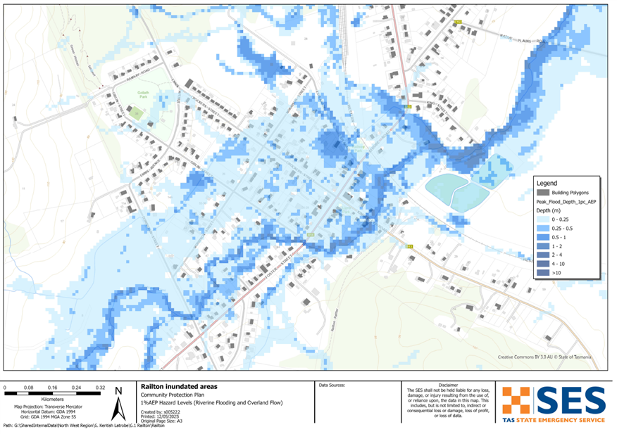
The 2011 flood was similar in magnitude to an event with an Annual Exceedance Probability (AEP) of approximately 1%, meaning it has about a 1 in 100 chance of occurring in any given year. This event inundated 60 houses and 14 businesses, and caused widespread disruption to roads and streets throughout the town.
In past floods, people from Railton have been trapped by flood waters in their cars and on their house roofs. Flooding of Redwater Creek in Railton often occurs at the same time as flooding of other water courses in the area, including the Mersey River and the Dasher River. This means that the roads between Railton and other towns such as Sheffield and Latrobe can be flooded and damaged. Emergency Services from other towns may not be able to access Railton in a flood.
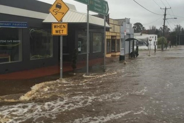
Image: Railton in flood 2016 (source: WMA Water)
どうすればいいですか?
- 自宅や事業所が浸水する可能性があるかどうか、地図で確認してください。.
- ご自宅または事業所を評価し、洪水による被害を最小限に抑える準備をしてください。.
- 洪水時に自宅、職場、学校に安全にたどり着けるか確認してください。.
- 自宅の緊急時計画を準備する。洪水による避難が必要かどうか考慮する。 緊急事態に備えよう– 個人および家庭向けの緊急事態への備えに関するガイド.
- If you are a primary producer, the Farm Flood Readiness Kit provides advice on preparing for a flood to help protect your business and stock.
- If you run a business or other organisation, check out the Tasmanian Government’s Emergency Ready Business tool online
- 孤立する可能性があり、サービスへのアクセスが必要な場合は、早期に避難する必要があるかもしれません。.
- 洪水のおそれのある地域でキャンプをする場合は、常に情報を入手し、洪水が予想される場合は早期に高台に避難するようにしてください。.
地図に示されているような、あるいはそれ以上にひどい洪水は再び起こるでしょう。二つの洪水は同じではありません。.
低地や水域の近くに住んでいる場合、家が浸水する可能性があります。家が安全でも、浸水地域を迂回する必要がある場合や、道路へのアクセスが遮断される場合があります。絶対に浸水した水の中を運転したり、入ったりしないでください。道路や橋が流されたり、安全でなくなったりする可能性があります。洪水時の移動は避けてください。.
何を知っておくべきかを知っておくことは、あなたの命を救い、財産を守るのに役立ちます。ホーム・エマージェンシー・プランを持つことは、準備の最善の方法の1つです。行動を起こす際の気象や降雨の引き金について決定してください。.
警告と重要な情報を理解する
周囲の状況に常に注意を払ってください。予報、観測、警報を定期的に確認してください。.
- お近くのABCラジオ局 または
 |
アドバイス(黄色) インシデントが発生しました。現時点では差し迫った危険はありません。状況が変わる可能性もありますので、随時最新情報をご確認ください。. |
 |
見て行動する(オレンジ) 脅威レベルが上昇しています。状況は変化しており、あなたとご家族を守るための行動を今すぐ開始する必要があります。 |
 |
緊急警報(赤) 緊急警報は最も高いレベルの警報です。危険な状態にあり、今すぐ行動を起こす必要があります。これ以上遅れると、命に危険が及びます。. |
 |
コミュニティアップデート(青): 特定のイベントやインシデントに関する、影響を受けた地域社会への具体的な情報と最新情報。. |
| インシデント(白) インシデントとは、緊急警報になる前の、事象の最初の発生のことです。インシデントが報告されるとすぐに、TasALERTはインシデントの種類や場所を含む基本的な情報を公開します。. |
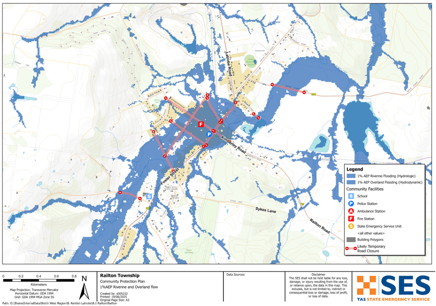
Flood levels at Railton
Severe Weather Warnings and Flood Watches can forecast the amount of rain likely in an area. See detailed rain forecasts for Railton on the MetEye page on the BoM website www.bom.gov.au/tas/forecasts/railton.shtml .
24 hour rainfall totals at Railton can help you estimate how much flooding could occur. Flooding can also occur if a large amount of rain falls quickly in a short time, or it rains for days in a row.
While no two floods are the same, the following describes what you can expect at different flood levels around Railton. Even if your property is not flooded, you need to think about access routes.
10% AEP (10% chance of occurring in any year)
Potential rainfall trigger: About 54 mm of rain in 6 hours @ Sheffield School Farm
What might happen:
-
- Around 80 homes and businesses could flood. This includes parts of Crockers Sr, Esplanade, Foster St, Giblin St, Kimberley Rd, Latrobe Rd and Morrison St.
-
- Local roads such as Dowbiggin, Foster, Giblin Morrison Crockers, Esplanade, Railton, New Bed and Native Plains Roads may be affected by floodwater.
-
- Important places like the fire station, service station, childcare centre, Telstra exchange and some shops could flood or become isolated.
-
- With roads and railway lines cut, travel in and out of town may be affected.
-
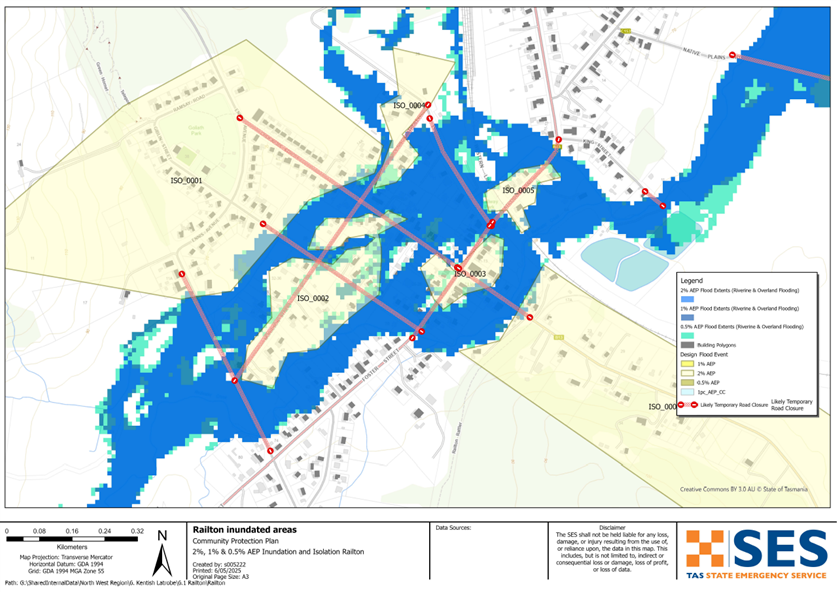
- Parts of the town could be cut off from each other.
2% AEP (2% chance of occurring in any year)
Potential rainfall trigger: About 80 mm of rain in 6 hours @ Sheffield School Farm
What might happen, as per 10% AEP plus:
-
- Flooding spreads further around the town. Around 95 homes and businesses may be flooded or isolated. This includes some properties in Dowbiggin and Calder St.
-
- Some parts of Leake St and King St may flood.
1% AEP (1% chance of occurring in any year)
Potential rainfall trigger: About 86 mm of rain in 6 hours @ Sheffield School Farm
-
- Widespread flooding with around 100 houses at risk being flooded, similar to 2011.
-
- Some unflooded homes may be isolated due to surrounding water.
-
- Sewerage treatment plant near King Street may flood.
-
- Railton could be isolated for longer periods of time.
Go to TasALERT.com or listen to ABC local radio for detailed up to date information and advice during heavy rainfall events.
リスクを知り、準備をして、可能な限りリスクを減らし、他者とつながり、警戒を怠らず、安全に行動しよう。.
洪水の前
緊急事態に備えよう – 個人および家庭向けの緊急事態への備えに関するガイド.
1. リスクを知る
タスマニアではしばしば洪水が発生し、広範囲にわたる甚大な被害をもたらすことがあります。過去200年間で、タスマニアでは洪水に関連した死者は78人にのぼります。このガイドは、お住まいの地域における洪水リスクを理解するのに役立つものです。.
2. ご家庭の準備
嵐や洪水に備えた緊急時対応計画を立てましょう
嵐や洪水が起きた時のことを考えておくということは、より準備ができていることであり、全員がより安全になるということです。家族全員が理解できる緊急時計画を立てましょう。計画を考えるためのチェックリストがありますので、をご覧ください。 緊急事態に備えよう – 個人および家庭向けの緊急事態への備えに関するガイド.
定期的に計画を確認し、世帯の全員で、洪水が発生した場合のシナリオを検討してテストしてください。.
緊急キットを準備する
準備完了
- 電池式ラジオと懐中電灯、予備電池
- 緊急時の計画など、重要な情報
- 緊急電話番号リスト
- 食べ物と水
- 救急箱
- ゴム製または丈夫な革製の手袋
必要に応じて荷造りする
- 暖かい服装、丈夫な靴またはブーツ
- 薬、眼鏡、またはその他の必需品
- 携帯電話と充電器
- ペットフードとその他の必要なもの
- 写真と思い出の品
- お金
- 重要書類、例えば
-
- 保険書類
-
- パスポートと
-
- 出生証明書
ラジオや懐中電灯の電池は定期的にテストしてください。.
3. 可能な限り、洪水によるリスクを減らしましょう
- 建物を購入、維持、開発する際は、嵐、洪水、その他の危険について考慮してください。.
- 自宅、事業所、または敷地内の電線近くにまたがっている木や枝を剪定または除去してください。.
- 雨どいと排水溝をきれいに掃除しておきましょう。.
4. 他の人とつながる
Know your neighbours and get involved in your community. A connected community is a safer and more resilient community in an emergency and can help everyone recover better afterwards. Check that family and neighbours are safe and aware of what’s happening.
その間
5. 最新の状態に保つ
周囲の状況に常に注意を払ってください。予報、観測、警報を定期的に確認してください。.
- お近くのABCラジオ局 または
- the 気象局 ウェブサイト.
6. 安全に行動する
- 子供たちを監督する。.
- 停電、断水、インターネット接続障害に備えましょう。.
- 緊急用キットの準備ができているか確認してください。.
- 排水溝など、浸水している場所には近づかないでください。. 決して 洪水の中を歩いたり、遊んだり、自転車や車で走ったりしないでください。水の下に何があるか、水深がどれくらいか、流れがどれほど速いかは、必ずしも目視では確認できません。わずか20センチほどの浅い場所でも、流れが速ければ流されて溺れる危険があります。洪水は危険です。.
自宅が浸水する可能性のある時期
- 家庭用品を高い場所に置いて、被害を最小限に抑えましょう。.
- 安全であれば、電気とガスを止めてください。.
- 下水が家に戻ってくるのを防ぐのに良い方法は、土のうをビニール袋に入れ、それをトイレに詰まって、排水溝やシンクを覆うことです。.
- 安全に脱出できるうちに立ち去れ。.
避難が必要な場合は
- SES / タスマニア警察からのアドバイスに従ってください。.
- 緊急キットを持って行ってください。.
- より安全な場所や避難所にいる友人や家族のところへ行ってください。.
- あなたの居場所を他の人に知らせてください。.
動物たちの世話をしてあげてください。
You are responsible for your animals in an emergency. If you have pets and other animals it will take you longer to evacuate in a flood or other emergency. Move livestock from flood prone areas well before flood waters may rise. For more information see
- the 一次生産者農業施設洪水対策ツールキット.
嵐の中や嵐の後には旅行を避けてください
- 観光はしないでください。観光客は緊急車両の通行を妨げ、事故の原因となります。.
- 危険にご注意ください(例:
-
- 道路上の水
-
- 損傷した電線
-
- 土砂崩れ
-
- 損傷した道路
-
- 倒木または屋根の鉄板。.
- 洪水の中を車で通行しないでください。洪水による死亡者や救助者のほとんどは、洪水の中を車で通行した人たちです。.
- 冠水していない道路では、速度を落として走行し、ヘッドライトを点灯させてください。.
その後
- ABCローカルラジオの最新情報、道路の再開、地域集会などの情報を引き続きお聞きください。.
- 自宅を出た場合は、SES(State Emergency Service)またはタスマニア警察が安全だと指示するまで帰宅しないでください。.
- 道路上の泥や瓦礫、道路・橋の損傷、清掃・修繕作業員などに注意してください。.
ご自宅が損傷した場合
- 被害状況を確認する際は、地面に留まってください。倒木、割れたガラス、屋根の破片など、危険な物には十分注意してください。.
- 丈夫なブーツ、手袋、保護衣を着用してください。.
- 浸水した建物内では、マッチやろうそくではなく、懐中電灯を使用してください。.
- 水道水が再び安全だと告げられるまで、飲む水はすべて煮沸してください。.
- Do not turn on it is tested by a licensed electrician or gas fitter for safety.
- 自宅が損傷し、他の場所にとどまる必要がある場合は、非常用キットとペットを連れて行ってください
- 安全であれば、損傷箇所の写真を撮って、保険会社に連絡してください。.
- 子供たちを監督する。.
- 近所の人が大丈夫か確認してください。.
詳細については、以下をご覧ください www.ses.tas.gov.au
最新情報とさらなる情報
Current warnings – TasALERT.com
Emergency Broadcasters – お近くのABCラジオ局
TASSES Social Media – facebook.com/sestasmania
洪水緊急事態への備え ses.tas.gov.au/flood-plan/
ナショナルリレーサービス (NRS) relayservice.gov.au
Emergency Broadcasters ABC East Devonport 100.5FM or listen online.
ケントッシュ評議会 www.kentish.tas.gov.au 6491 0200
Developed in partnership with Kentish Council.
免責事項
The maps show potential flooding risks from consistent levels of rainfall across catchments, such as a 1% Annual Exceedance Probability (AEP). In flooding events, rainfall is likely to be more inconsistent across a catchment, so these flood maps should be considered indicative only. The mapped areas of flood risk show higher probability of inundation. Other areas have lower probability of flooding, but in severe and rare events (rarer than 1%AEP), other lower areas may be also at risk of inundation.
本ガイドに記載されている情報は、発行時点での最新情報です。掲載データの有効性および正確性を確保するために万全を期しておりますが、州緊急事態局は、データの誤りや欠落について責任を負いません。標準規定をご参照ください。 タスマニア州政府の著作権および免責事項に関する声明 詳細については.
