フォート ローダーデールからセブンマイルビーチへの洪水ガイド
Coastal Inundation, riverine and direct rainfall flooding information for communities on Acton Creek, other minor waterways, and the coasts of Frederick Henry Bay and Ralphs Bay
Draft version 0.1b September 2025 for community input – email ses@ses.tas.gov.au – see PDF version
地図をより詳細に表示するには、, タスマニア州洪水戦略マップをご覧ください.
洪水リスクを理解し、備えましょう
In a major flood, this area could be widely affected by
- direct rainfall flooding (flash flooding) or
- flooding from the ocean (coastal inundation).
Flooding from rivers and waterways (riverine flooding) would only impact parts of
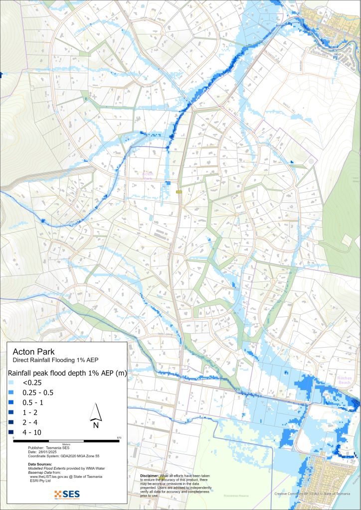
- Acton Park, and
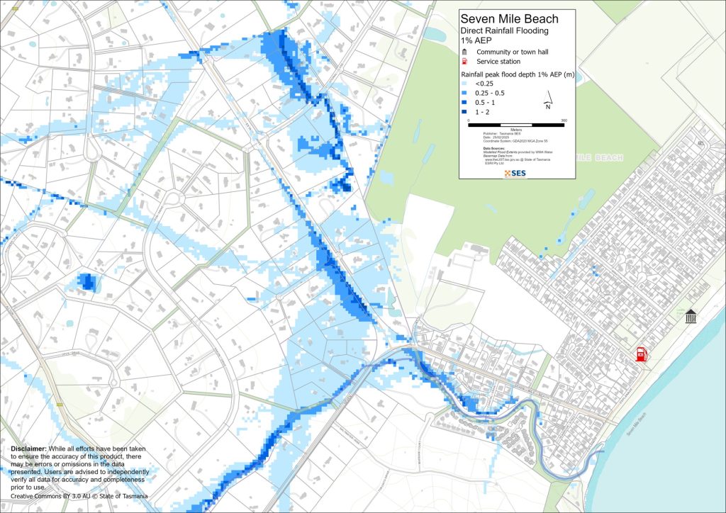
- Seven Mile Beach around Acton Creek.
The coastline of this area may be affected by
- high tides
- waves from storms, and
- erosion.
This could happen during heavy rain and add to other flooding.
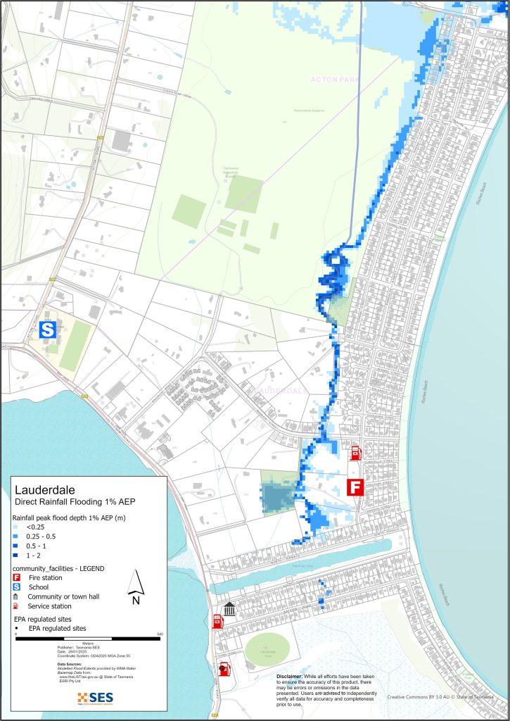
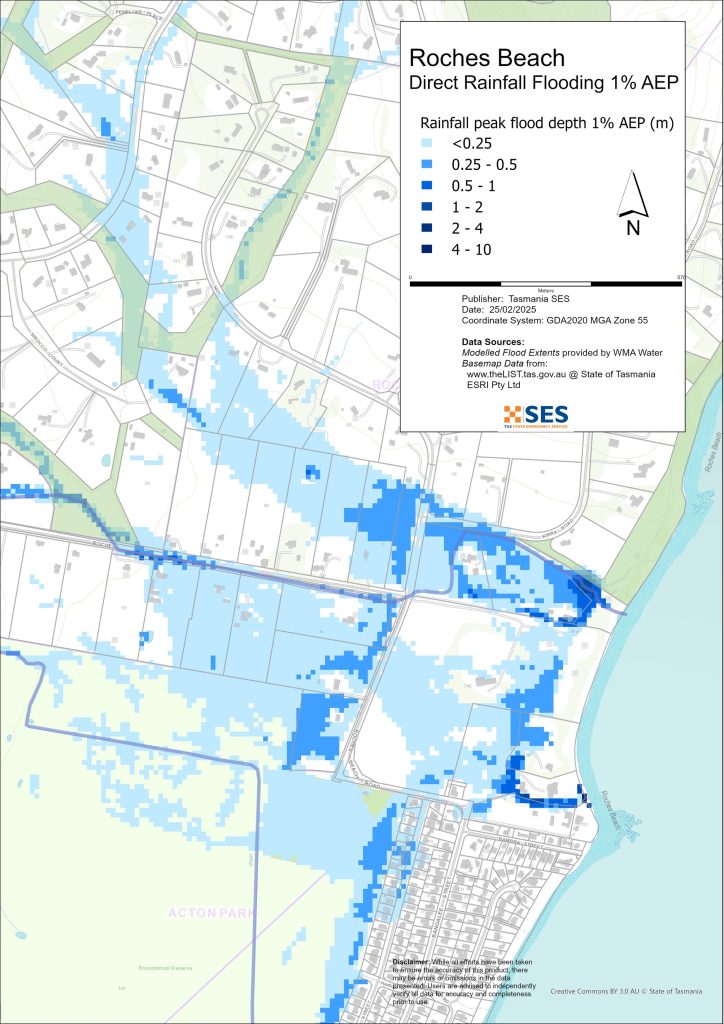
Houses along Acton Creek and between the golf course and Seven Mile Beach Rd are at risk of flooding. The corner of Seven Mile Beach Road and Estate Drive may flood from direct rainfall. Other areas at risk of direct rainfall flooding include
- large parts of Roches Beach
- properties south of Ringwood Rd and Mannata St
- other low-lying streets in Lauderdale and International Close in Acton Park.
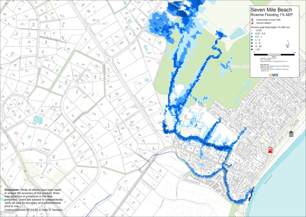
The maps in this guide show the level of flooding that has a 1% chance of happening any year from both rivers and direct rainfall flooding (known as 1% annual exceedance probability, or AEP). You are likely to experience flooding such as that shown in the maps in your lifetime. Tasmanians need to prepare for flood events that may not happen often, as well as the minor flooding they may have experienced.
Clarence City Council has flood mapping across this area that includes the modelled effects of climate change. You can see it online at www.ccc.tas.gov.au/living/your-neighbourhood/flooding/.
Even if your home is not at risk of flooding, you should prepare for isolation plus potential power and telecommunications outages. Depending on where the rain falls and how heavy it is, local and major roads may be impassable. For example, Seven Mile Beach Road may be flooded by Acton Creek, and Acton Road may see flash flooding. Travel in the area is likely to be difficult or impossible until roads are clear. If you are safe at home or elsewhere, it is usually best you stay where you are until the flooding subsides, unless there is an emergency. If you need to evacuate, you should leave early, before flood waters rise.
ABCローカルラジオ936AMで、注意事項とアドバイスをお聞きください。.
洪水のリスクはありますか?
The most serious flood in recent history was in June of 1974. June of 2011 also saw serious flooding in this area. Damaging storms and tides have also been recorded. In July 2011 tides and winds caused flooding and damage in Lauderdale and Roches Beach. This kind of weather may be more common in the future due to increased average temperatures.
ご注意ください
この計画の地図は、タスマニア戦略洪水マッピング(TSFM)プロジェクトのデータを示しています。このデータは、洪水ハザードデータレイヤーで探索できます。 www.thelist.tas.gov.au. Clarence City Council has detailed flood studies for these areas, see www.ccc.tas.gov.au/living/your neighbourhood/flooding/. CCCデータには気候変動予測が含まれており、より浅い深度での浸水を示すため、下記地図に示されるTSFMの範囲よりも洪水範囲がかなり異なり、一般的に広くなります。このデータは過去の降雨量平均に基づいています。.
どうすればいいですか?
- 自宅や事業所が浸水する可能性があるかどうか、地図で確認してください。.
- ご自宅または事業所を評価し、洪水による被害を最小限に抑える準備をしてください。.
- 洪水時に自宅、職場、学校に安全にたどり着けるか確認してください。.
- 自宅の緊急時計画を準備する。洪水による避難が必要かどうか考慮する。 緊急事態に備えよう– 個人および家庭向けの緊急事態への備えに関するガイド.
- If you are a primary producer, the Farm Flood Readiness Kit provides advice on preparing for a flood to help protect your business and stock.
- If you run a business or other organisation, check out the Tasmanian Government’s Emergency Ready Business tool online
- 孤立する可能性があり、サービスへのアクセスが必要な場合は、早期に避難する必要があるかもしれません。.
- 洪水のおそれのある地域でキャンプをする場合は、常に情報を入手し、洪水が予想される場合は早期に高台に避難するようにしてください。.
地図に示されているような、あるいはそれ以上にひどい洪水は再び起こるでしょう。二つの洪水は同じではありません。.
低地や水域の近くに住んでいる場合、家が浸水する可能性があります。家が安全でも、浸水地域を迂回する必要がある場合や、道路へのアクセスが遮断される場合があります。絶対に浸水した水の中を運転したり、入ったりしないでください。道路や橋が流されたり、安全でなくなったりする可能性があります。洪水時の移動は避けてください。.
何を知っておくべきかを知っておくことは、あなたの命を救い、財産を守るのに役立ちます。ホーム・エマージェンシー・プランを持つことは、準備の最善の方法の1つです。行動を起こす際の気象や降雨の引き金について決定してください。.
気象局の予報、警報、観測
局は発行します 大雨による鉄砲水が発生する可能性のある洪水警報、悪天候警報、および/または雷警報 いつでも 大雨 地域で予想されます。警報が出てから大雨が降るまでの時間は、1時間から24時間以上と幅があります。.
There are no formal flood warning levels for waterways in this area.
降雨観測 at Hobart Airport, Hobart, Clifton Beach and other nearby rain gauges can indicate possible flood risks. Given the very short warning times, it is best to act on the predictive BoM warnings rather than wait for any flood alerts during rainfall.
ザ クーンヤ山レーダー is useful to be aware in real-time where heavy rainfall is falling. Radar Rainfall estimates can also fill in gaps in areas where there are no rainfall stations.
警告と重要な情報を理解する
周囲の状況に常に注意を払ってください。予報、観測、警報を定期的に確認してください。.
- お近くのABCラジオ局 または
 |
アドバイス(黄色) インシデントが発生しました。現時点では差し迫った危険はありません。状況が変わる可能性もありますので、随時最新情報をご確認ください。. |
 |
見て行動する(オレンジ) 脅威レベルが上昇しています。状況は変化しており、あなたとご家族を守るための行動を今すぐ開始する必要があります。 |
 |
緊急警報(赤) 緊急警報は最も高いレベルの警報です。危険な状態にあり、今すぐ行動を起こす必要があります。これ以上遅れると、命に危険が及びます。. |
 |
コミュニティアップデート(青): 特定のイベントやインシデントに関する、影響を受けた地域社会への具体的な情報と最新情報。. |
| インシデント(白) インシデントとは、緊急警報になる前の、事象の最初の発生のことです。インシデントが報告されるとすぐに、TasALERTはインシデントの種類や場所を含む基本的な情報を公開します。. |
洪水レベル
While no two floods are the same, the following describes what you can expect at different flood levels around the area. Even if your property is not flooded, you need to think about access. Different levels of rainfall can cause flooding depending on its intensity, duration and how wet the ground is beforehand and where the rain falls. Tide levels are also important, as they affect:
- ocean waves
- coastal erosion
- groundwater level, and
- drainage through the stormwater system.
小規模な洪水
A minor flood can inundate low lying streets, parkland, gardens, orchards and paddocks. Vehicles, livestock and equipment should be moved. There may also be flooding across some minor roads. Paddocks north of Acton and the Royal Hobart Golf Course in Lauderdale may flood in parts.
中程度の洪水
There is more extensive flooding of agricultural land and some buildings may be impacted to above floor height. Properties may be isolated for a few hours as minor roads become flooded. Roads at most risk in moderate flooding include:
- International Close, in Acton Park
- Seven Mile Beach Road, Lewis Avenue, Regal Court and Seabrook Street in Seven Mile Beach.
Some properties in these streets may flood but it is unlikely to be above house floor height.
大規模な洪水
There is at least a 2% chance in any year of major flooding in this area.
This level of flooding could be a result of about 55-60mm of rain over 6 hours at the Hobart Airport, for example.
Major flooding will impact many streets and may flood houses. Acton Creek could flood parts of Acton Park and Seven Mile Beach, including
- International Close
- Seven Mile Beach Road
- Coastal Drive
- Lewis Avenue
- Seabrook Street, and
- Regal Court.
Depending on where and when the rain falls, flash flooding could impact many areas, including
- In Acton Park
- Acton Road
- Estate Drive
- International Close
- properties near Upton Creek and other low-lying streets and houses.
- In Seven Mile Beach, properties on Vivalanett Close and Seven Mile Beach Road
- Possible widespread impacts in Roches Beach
- Terrina Street in the north of Lauderdale
Also at risk are low-lying properties throughout Lauderdale, including on
- Mannata Street
- North Terrace, and
- Bayview Road.
During a major flood, the tide and ocean swell will influence flooding in this area. High tides raise the water table and slow or prevent stormwater drainage, increasing flooding. Waves and high tides can
- cause damage and erosion and
- change the way floodwater moves through this area.
These effects are difficult to predict and are not included on the maps in this plan.
Go to TasALERT.com or listen to ABC local radio for detailed up to date information and advice during heavy rainfall events.
リスクを知り、準備をして、可能な限りリスクを減らし、他者とつながり、警戒を怠らず、安全に行動しよう。.
洪水の前
緊急事態に備えよう – 個人および家庭向けの緊急事態への備えに関するガイド.
1. リスクを知る
タスマニアではしばしば洪水が発生し、広範囲にわたる甚大な被害をもたらすことがあります。過去200年間で、タスマニアでは洪水に関連した死者は78人にのぼります。このガイドは、お住まいの地域における洪水リスクを理解するのに役立つものです。.
2. ご家庭の準備
嵐や洪水に備えた緊急時対応計画を立てましょう
嵐や洪水が起きた時のことを考えておくということは、より準備ができていることであり、全員がより安全になるということです。家族全員が理解できる緊急時計画を立てましょう。計画を考えるためのチェックリストがありますので、をご覧ください。 緊急事態に備えよう – 個人および家庭向けの緊急事態への備えに関するガイド.
定期的に計画を確認し、世帯の全員で、洪水が発生した場合のシナリオを検討してテストしてください。.
緊急キットを準備する
準備完了
- 電池式ラジオと懐中電灯、予備電池
- 緊急時の計画など、重要な情報
- 緊急電話番号リスト
- 食べ物と水
- 救急箱
- ゴム製または丈夫な革製の手袋
必要に応じて荷造りする
- 暖かい服装、丈夫な靴またはブーツ
- 薬、眼鏡、またはその他の必需品
- 携帯電話と充電器
- ペットフードとその他の必要なもの
- 写真と思い出の品
- お金
- 重要書類、例えば
-
- 保険書類
-
- パスポートと
-
- 出生証明書
ラジオや懐中電灯の電池は定期的にテストしてください。.
3. 可能な限り、洪水によるリスクを減らしましょう
- 建物を購入、維持、開発する際は、嵐、洪水、その他の危険について考慮してください。.
- 自宅、事業所、または敷地内の電線近くにまたがっている木や枝を剪定または除去してください。.
- 雨どいと排水溝をきれいに掃除しておきましょう。.
4. 他の人とつながる
Know your neighbours and get involved in your community. A connected community is a safer and more resilient community in an emergency and can help everyone recover better afterwards. Check that family and neighbours are safe and aware of what’s happening.
その間
5. 最新の状態に保つ
周囲の状況に常に注意を払ってください。予報、観測、警報を定期的に確認してください。.
- お近くのABCラジオ局 または
- the 気象局 ウェブサイト.
6. 安全に行動する
- 子供たちを監督する。.
- 停電、断水、インターネット接続障害に備えましょう。.
- 緊急用キットの準備ができているか確認してください。.
- 排水溝など、浸水している場所には近づかないでください。. 決して 洪水の中を歩いたり、遊んだり、自転車や車で走ったりしないでください。水の下に何があるか、水深がどれくらいか、流れがどれほど速いかは、必ずしも目視では確認できません。わずか20センチほどの浅い場所でも、流れが速ければ流されて溺れる危険があります。洪水は危険です。.
自宅が浸水する可能性のある時期
- 家庭用品を高い場所に置いて、被害を最小限に抑えましょう。.
- 安全であれば、電気とガスを止めてください。.
- 下水が家に戻ってくるのを防ぐのに良い方法は、土のうをビニール袋に入れ、それをトイレに詰まって、排水溝やシンクを覆うことです。.
- 安全に脱出できるうちに立ち去れ。.
避難が必要な場合は
- SES / タスマニア警察からのアドバイスに従ってください。.
- 緊急キットを持って行ってください。.
- より安全な場所や避難所にいる友人や家族のところへ行ってください。.
- あなたの居場所を他の人に知らせてください。.
動物たちの世話をしてあげてください。
You are responsible for your animals in an emergency. If you have pets and other animals it will take you longer to evacuate in a flood or other emergency. Move livestock from flood prone areas well before flood waters may rise. For more information see
- the 一次生産者農業施設洪水対策ツールキット.
嵐の中や嵐の後には旅行を避けてください
- 観光はしないでください。観光客は緊急車両の通行を妨げ、事故の原因となります。.
- 危険にご注意ください(例:
-
- 道路上の水
-
- 損傷した電線
-
- 土砂崩れ
-
- 損傷した道路
-
- 倒木または屋根の鉄板。.
- 洪水の中を車で通行しないでください。洪水による死亡者や救助者のほとんどは、洪水の中を車で通行した人たちです。.
- 冠水していない道路では、速度を落として走行し、ヘッドライトを点灯させてください。.
その後
- ABCローカルラジオの最新情報、道路の再開、地域集会などの情報を引き続きお聞きください。.
- 自宅を出た場合は、SES(State Emergency Service)またはタスマニア警察が安全だと指示するまで帰宅しないでください。.
- 道路上の泥や瓦礫、道路・橋の損傷、清掃・修繕作業員などに注意してください。.
ご自宅が損傷した場合
- 被害状況を確認する際は、地面に留まってください。倒木、割れたガラス、屋根の破片など、危険な物には十分注意してください。.
- 丈夫なブーツ、手袋、保護衣を着用してください。.
- 浸水した建物内では、マッチやろうそくではなく、懐中電灯を使用してください。.
- 水道水が再び安全だと告げられるまで、飲む水はすべて煮沸してください。.
- Do not turn on it is tested by a licensed electrician or gas fitter for safety.
- 自宅が損傷し、他の場所にとどまる必要がある場合は、非常用キットとペットを連れて行ってください
- 安全であれば、損傷箇所の写真を撮って、保険会社に連絡してください。.
- 子供たちを監督する。.
- 近所の人が大丈夫か確認してください。.
詳細については、以下をご覧ください www.ses.tas.gov.au
最新情報とさらなる情報
Current warnings – TasALERT.com
Emergency Broadcasters – お近くのABCラジオ局
TASSES Social Media – facebook.com/sestasmania
洪水緊急事態への備え ses.tas.gov.au/flood-plan/
ナショナルリレーサービス (NRS) relayservice.gov.au
Local Emergency Broadcasters ABC 936AM
Clarence City Council ccc.tas.gov.au clarence@ccc.tas.gov.au 6217 9500
免責事項
The maps show potential flooding risks from consistent levels of rainfall across catchments, such as a 1% Annual Exceedance Probability (AEP). In flooding events, rainfall is likely to be more inconsistent across a catchment, so these flood maps should be considered indicative only. The mapped areas of flood risk show higher probability of inundation. Other areas have lower probability of flooding, but in severe and rare events (rarer than 1%AEP), other lower areas may be also at risk of inundation.
本ガイドに記載されている情報は、発行時点での最新情報です。掲載データの有効性および正確性を確保するために万全を期しておりますが、州緊急事態局は、データの誤りや欠落について責任を負いません。標準規定をご参照ください。 タスマニア州政府の著作権および免責事項に関する声明 詳細については.
