
클레어몬트 홍수 안내
몬트로즈(아이슬릿 리블릿)와 블랙 스네이크 리블릿(그랜튼) 사이 지역, 렌럭, 로제타, 시그웰, 베리데일, 오스틴스 페리를 포함한 지역의 강 및 갑작스러운 홍수 정보
또한 가까운 것을 보라 글레노키 시 및 교외 지역을 위한 홍수 안내 (아이슬릿 리블렛 남쪽)
Version 1.1 November 2025 – Download PDF version

지도의 정보를 자세히 보려면 www.gcc.tas.gov.au/residents/your-home/floods-and-stormwater/

홍수 위험을 이해하고 대비하세요
웰링턴 레인지 전역에 폭우를 동반한 심각한 폭풍이 발생하면 로제타에서 그랜턴에 이르는 여러 수로가 범람할 수 있습니다. 도로, 학교, 상업 시설 및 부동산이 침수될 수 있으며 브로커 고속도로가 여러 곳에서 차단될 수 있습니다. 이로 인해 해당 교외의 넓은 지역이 고립될 수 있습니다. 단기간 동안 이동 및 사업 운영이 어렵거나 불가능할 수 있습니다.
개울과 시냇물에서 발생하는 홍수 외에도 폭우가 이 지역에 직접적인 홍수를 유발할 수 있습니다. 이 계획의 지도에서 강과 폭우로 인한 홍수를 모두 확인할 수 있습니다.
폭우가 내리는 동안과 직후, 급경사 지역에서는 산사태 위험이 있어 도로와 재산에 피해를 줄 수 있습니다. 이 계획의 해안 지역을 따라서는 더웬트 강에서의 조수, 폭풍, 홍수로 인한 홍수와 침식도 가능합니다.
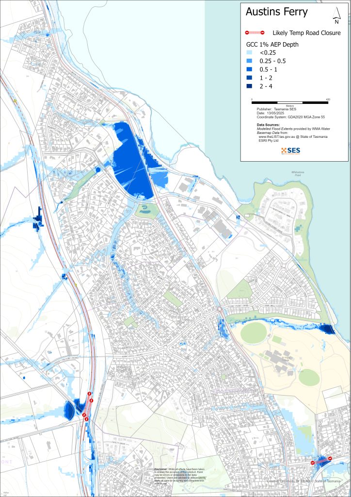
이 안내서의 지도는 매년 1%의 확률로 발생할 수 있는 홍수 수준을 보여줍니다(이를 1% 연간 초과 확률, 즉 AEP라고 합니다). 여러분은 일생 동안 지도에 표시된 것과 같은 홍수를 경험할 가능성이 높습니다. 태즈메이니아 주민들은 자주 발생하지 않을 수 있는 홍수 사태뿐만 아니라, 이미 경험했을 수도 있는 소규모 홍수에도 대비해야 합니다.
집이 침수되지 않더라도 고립되거나 전력 및 통신망이 끊길 가능성에 대비해야 합니다. 예를 들어:
- 브루커 고속도로는 그랜턴, 오스틴스 페리, 클레어몬트, 치그웰, 몬트로즈 가장자리에서 차단될 수 있습니다.
- 주요 도로가 여러 곳에서 침수될 수 있습니다.
- 지하도를 통해 브루커 고속도로를 건너는 도로는 침수될 가능성이 높습니다.
비가 내리는 곳과 강우량에 따라 이 지역의 많은 도로가 통행 불가능해질 수 있습니다. 도로가 정리될 때까지 이 지역에서의 이동은 어렵거나 불가능할 가능성이 높습니다. 안전한 곳에 있거나 집에 있다면, 비상 상황이 아닌 한 홍수가 가라앉을 때까지 그 자리에 머무르는 것이 좋습니다. 대피해야 한다면, 홍수가 높아지기 전에 일찍 떠나야 합니다.
TasALERT.com으로 가거나 ABC 지역 라디오 936AM을 청취하여 경고 및 조언을 받으십시오.
홍수 위험이 있습니까?
쿠나니/마운트 웰링턴의 폭우는 거의 예고 없이 주변 수로 어디에나 돌발 홍수를 일으킬 수 있습니다. 비가 내리는 방식에 따라 개울, 작은 시내, 폭풍우 유출수는 예측하기 어려운 돌발 홍수를 일으킬 수 있습니다.
이 지역의 홍수 피해 기록이 잘 남아 있지 않습니다.
무엇을 해야 할까요?
- 집이나 사업장이 침수될 수 있는지 지도를 확인해 보세요.
- 가정이나 사업장을 평가하고 가능한 홍수 피해를 최소화하도록 준비하세요.
- 홍수 시 집, 직장 또는 학교에 안전하게 갈 수 있는지 확인하세요.
- 집 비상 계획을 준비하세요. 홍수가 발생하기 전에 대피해야 하는지 고려해 보세요. 비상 사태에 대비하세요– 개인 및 가구 비상 대비 안내서.
- 당신이 1차 생산자라면, 농장 홍수 대비 키트 사업체와 재고를 보호하는 데 도움이 되는 홍수 대비 요령을 제공합니다.
- If you run a business or other organisation, check out the Tasmanian Government’s Emergency Ready Business tool online
- 고립될 수 있고 서비스를 이용해야 한다면 조기에 대피해야 할 수도 있습니다.
- 홍수에 취약한 지역에서 캠핑하는 경우, 관련된 정보를 계속 파악하고 홍수가 우려되면 일찍 높은 곳으로 대피하도록 하십시오.
지도에 표시된 것과 같은 홍수, 혹은 그보다 더 심각한 홍수가 다시 발생할 것입니다. 두 번의 홍수가 똑같은 경우는 없습니다.
저지대나 하천 근처에 거주하는 경우, 집이 침수될 수 있습니다. 집이 안전하더라도 침수된 지역을 우회해야 하거나 도로가 차단될 수 있습니다. 절대로 침수된 물 속으로 차를 몰거나 들어가지 마십시오. 도로와 다리가 유실되었거나 위험할 수 있습니다. 홍수 발생 시에는 외출을 삼가십시오.
무엇을 해야 할지 아는 것은 생명을 구하고 재산을 보호하는 데 도움이 될 수 있습니다. 가정 비상 계획을 세우는 것은 대비하는 가장 좋은 방법 중 하나입니다. 행동할 시점을 결정하기 위한 날씨와 강우량 트리거를 결정하십시오.
기상청 예보, 경보 및 관측
국은 발행한다 폭우로 인한 돌발 홍수가 발생할 수 있다는 홍수 경보, 악천후 경보 및/또는 뇌우 경보 언제든지 폭우 예상됩니다. 경고와 폭우 발생 사이의 시간은 한 시간에서 24시간 이상까지 다양할 수 있습니다.
그lenorchy, 호바트, 킹스버로 카운슬은 kunanyi/마운트 웰링턴 주변 지역이 유사한 돌발 홍수 위험과 시간을 공유하기 때문에 홍수 경고 시스템을 공유합니다. 이 시스템을 통해 지역 카운슬과 SES는 홍수 위험을 판단하고 모니터링하며 필요에 따라 경고를 발령할 수 있습니다. 이 지역의 수로는 너무 짧기 때문에 하천에 대한 공식적인 경고 수준은 없습니다.
강우 관측 클레어몬트, 브리지워터, 마운트 드로메더리, 콜린스베일 및 기타 인근 비 측정기를 통해 가능한 홍수 위험을 알 수 있습니다. 경고 시간이 매우 짧기 때문에 강우 중 홍수 경보를 기다리기보다 BOM의 예측 경고에 따라 조치를 취하는 것이 가장 좋습니다.
그 쿤야 산 레이더 is useful to be aware in real-time where heavy rainfall is falling. Radar Rainfall estimates can also fill in gaps in areas where there are no rainfall stations.
경고와 중요 정보를 이해하십시오
주변 상황에 항상 주의를 기울이십시오. 예보, 관측 및 경고를 정기적으로 확인하십시오.
 |
조언 (노랑): 사건이 시작되었습니다. 즉각적인 위험은 없습니다. 상황이 변할 경우 최신 정보를 계속 확인하십시오. |
 |
시청 및 행동 (주황색) 위협 수준이 높아졌습니다. 상황이 변하고 있으니, 귀하와 가족을 보호하기 위해 지금 바로 행동을 시작해야 합니다. |
 |
긴급 경보 (빨강): 긴급 경보는 최고 수준의 경고입니다. 위험에 처해 즉시 조치를 취해야 할 수 있습니다. 지금 지체하면 생명이 위험해질 수 있습니다. |
 |
커뮤니티 업데이트 (파랑): 특정 사건이나 사고에 대한 영향을 받은 지역사회를 위한 구체적인 정보와 업데이트. |
| 사건 (흰색): 사고는 비상 경보가 발령되기 이전의 최초 발생 사건입니다. 사고가 보고되는 즉시 TasALERT는 사고 유형 및 위치를 포함한 기본 정보를 게시합니다. |
홍수 수위
두 번의 홍수가 똑같지는 않지만, 다음은 지역별 다양한 홍수 수준에 대해 예상할 수 있는 내용입니다. 재산이 침수되지 않더라도 접근성에 대해 생각해야 합니다. 강우 강도, 지속 시간, 사전 지면 상태, 강우량 및 강우 지점에 따라 다양한 수준의 강우량이 홍수를 일으킬 수 있습니다.
경미한 침수
저지대, 공원, 과수원, 개울 및 시냇가 주변 지역에 약간의 홍수가 발생할 수 있습니다. 차량과 가축은 안전을 위해 옮겨야 합니다. 일부 작은 도로가 침수될 수 있습니다.
중간 침수
보통 수준의 홍수에서는 더 광범위한 침수가 발생하며 더 많은 토지, 도로 및 일부 건물이 침수될 수 있습니다.
애벗츠필드 리블렛, 힐튼 크릭, 폴크너스 리블렛, 아일렛 리블렛은 중간 규모 홍수 발생 시 일부 건물에 침수 피해를 줄 수 있습니다. 하지만 주택 바닥 높이 이상으로 침수될 가능성은 낮습니다.
대규모 홍수
대규모 홍수가 발생하면 이 지역 전반에 걸쳐 광범위한 홍수가 발생하겠지만 대부분 얕은 물에 잠길 것입니다. 가장 위험한 홍수는 다음 지역에서 발생할 가능성이 높습니다.
- 브루커 하이웨이, 베리데일 로드 근처
- 브루커 고속도로, 박스힐 로드 북쪽, 어퍼 힐튼 로드 근처
- 굴즈 라군 근처 주요 도로
- 클레어몬트 컬리지 캠퍼스 근처 클레어몬트 링크 로드,
- 애벗츠필드 로드, 스트래스 애븐 드라이브, 메리스 호프 로드
- 로스니스 리불렛
이 지역의 작은 강과 개천 근처의 부동산은 대홍수 발생 시 바닥 높이 이상으로 침수될 수 있습니다. 주요 교통로를 포함한 많은 도로가 침수되어 통행이 불가능해질 것입니다.
글렌러스크 호수는 당분간 해안과 분리될 수 있습니다.


Go to TasALERT.com or listen to ABC local radio for detailed up to date information and advice during heavy rainfall events.
위험을 인지하고, 대비하며, 가능한 위험을 줄이고, 다른 사람들과 연결하고, 경계를 늦추지 말고 안전하게 행동하십시오.
홍수 전에
비상 사태에 대비하세요 – 개인 및 가구 비상 대비 안내서.
1. 당신의 위험을 알아라
태즈메이니아에서는 홍수가 자주 발생하며 광범위하고 심각한 피해를 야기할 수 있습니다. 지난 200년 동안 태즈메이니아에서는 홍수와 관련된 사망자가 78명 발생했습니다. 이 가이드는 귀하의 지역에서의 홍수 위험을 이해하는 데 도움을 드리기 위한 것입니다.
2. 집안일 준비
폭풍우와 홍수에 대비한 비상 계획을 세우십시오.
폭풍이나 홍수 상황에서 무엇을 할지 생각해 보는 것은 더 잘 준비되어 있고 모두의 안전을 보장하는 데 도움이 됩니다. 가족 모두가 이해하는 비상 계획을 세우세요. 계획 수립에 도움이 되는 체크리스트가 있습니다. 비상 사태에 대비하세요 – 개인 및 가구 비상 대비 안내서.
주기적으로 계획을 확인하고, 가정에 영향을 미칠 수 있는 홍수 시나리오에 대해 온 가족이 함께 생각해 보며 계획을 시험해 보세요.
비상 용품 준비
준비 완료
- 배터리식 라디오와 손전등, 여분의 배터리
- 비상 계획과 같은 중요 정보
- 비상 전화번호 목록
- 음식과 물
- 구급 상자
- 고무 또는 튼튼한 가죽 장갑
필요할 때 짐을 싸세요
- 따뜻한 옷, 튼튼한 신발 또는 부츠
- 의약품, 안경 또는 기타 필수품
- 휴대폰과 충전기
- 애완동물 사료와 그 외 필요한 모든 것
- 사진과 특별한 기념품
- 돈
- 중요한 서류, 예를 들어
-
- 보험 서류
-
- 여권 및
-
- 출생증명서
라디오와 손전등의 배터리를 정기적으로 점검하세요.
3. 가능한 경우 홍수 위험을 줄이십시오
- 폭풍, 홍수 및 기타 위험 요소를 부동산 구매, 유지 또는 개발 시 고려하십시오.
- 집, 사업체 또는 재산 내 전선 근처에 늘어진 나무나 나뭇가지를 정리하거나 제거하십시오.
- 배수구와 도랑을 깨끗하게 유지하십시오.
4. 다른 사람들과 연결하기
Know your neighbours and get involved in your community. A connected community is a safer and more resilient community in an emergency and can help everyone recover better afterwards. Check that family and neighbours are safe and aware of what’s happening.
동안
5. 최신 정보를 유지하십시오
주변 상황에 항상 주의를 기울이십시오. 예보, 관측 및 경고를 정기적으로 확인하십시오.
- 더 기상청 웹사이트.
6. 안전하게 행동하기
- 어린이들을 감독하다.
- 정전, 단수, 인터넷 끊김 등 비상 상황에 대비하십시오.
- 비상 용품을 준비해 두었는지 확인하세요.
- 배수구와 같이 침수된 지역은 피하십시오. 절대 침수된 물에서 걷거나, 놀거나, 타거나 운전하지 마십시오. 물 아래 무엇이 있는지, 물이 얼마나 깊거나 빠르게 흐르는지 항상 알 수는 없습니다. 빠르게 흐르는 물은 20cm만으로도 휩쓸려 익사하기 쉽습니다. 홍수 물은 위험할 수 있습니다.
집이 침수될 수 있을 때
- 가구 등을 높은 곳에 올려 피해를 최소화하세요.
- 전기 및 가스를 안전하게 차단하십시오.
- 하수구가 집안으로 역류하는 것을 막는 좋은 방법은 모래주머니를 비닐봉지 안에 넣고 변기를 막거나 배수구 및 세면대를 덮는 데 사용하는 것입니다.
- 안전하게 빠져나갈 수 있을 때 나오세요.
대피해야 하는 경우
- SES / 태즈메이니아 경찰의 조언을 따르십시오.
- 비상용품을 챙기세요.
- 안전한 장소나 대피소에 있는 친구나 가족에게 가세요.
- 다른 사람들에게 당신이 어디에 갔는지 알려주세요.
동물을 잘 돌봐주세요
You are responsible for your animals in an emergency. If you have pets and other animals it will take you longer to evacuate in a flood or other emergency. Move livestock from flood prone areas well before flood waters may rise. For more information see
폭풍우가 치는 동안과 폭풍우가 지난 직후에는 여행을 피하십시오.
- 관광을 가지 마세요. 관광객은 응급 서비스 제공을 지연시키고 사고를 유발합니다.
- 위험에 주의하십시오.
-
- 도로 위 물
-
- 전선 손상
-
- 산사태
-
- 도로 파손
-
- 쓰러지는 나무나 함석.
- 침수된 물을 절대 운전하지 마십시오. 홍수 사망 및 구조의 대부분은 침수된 물을 운전하는 사람들로 인해 발생합니다.
- 차량 통행이 가능한 도로는 천천히 운전하고 전조등을 켜세요.
이후
- ABC 지역 라디오 업데이트, 도로 재개, 지역 주민 회의 등에 계속 귀 기울여 주세요.
- 집을 떠났다면, SES나 태즈메이니아 경찰이 안전하다고 할 때까지 집으로 돌아가지 마십시오.
- 도로 위의 흙이나 잔해, 손상된 도로/다리, 청소 및 보수 작업 인원 등 도로 위험 요소를 인지하십시오.
집이 손상되었다면
- 지붕이나 지면에서 손상을 확인하세요. 넘어진 나무, 깨진 유리, 부서진 지붕 또는 기타 위험에 주의하세요.
- 튼튼한 부츠, 장갑, 보호복을 착용하십시오.
- 침수된 건물 내부에서는 성냥이나 촛불을 사용하지 말고, 손전등을 사용하십시오.
- 마실 물은 수돗물이 다시 안전하다는 지시가 있을 때까지 모두 끓이세요.
- Do not turn on it is tested by a licensed electrician or gas fitter for safety.
- 집이 손상되어 다른 곳에 머물러야 한다면, 비상 용품과 반려동물을 챙기세요.
- 가능하다면 안전하게 주변의 손상된 부분을 촬영하고 보험 회사에 연락하십시오.
- 어린이들을 감독하다.
- 이웃들이 괜찮은지 확인해 보세요.
추가 정보는 다음을 참조하십시오 www.ses.tas.gov.au
정보를 얻고 추가 정보를 얻기
Current warnings – TasALERT.com
Emergency Broadcasters – 여러분의 지역 ABC 라디오 방송국
TASSES Social Media – facebook.com/sestasmania
홍수 비상사태 대비 ses.tas.gov.au/flood-plan/
국가 중계 서비스 (NRS) 릴레이서비스.gov.au
글레노키 시의회 6216 6800
Local Emergency Broadcasters ABC 936AM
면책 조항
The maps show potential flooding risks from consistent levels of rainfall across catchments, such as a 1% Annual Exceedance Probability (AEP). In flooding events, rainfall is likely to be more inconsistent across a catchment, so these flood maps should be considered indicative only. The mapped areas of flood risk show higher probability of inundation. Other areas have lower probability of flooding, but in severe and rare events (rarer than 1%AEP), other lower areas may be also at risk of inundation.
이 가이드의 정보는 발행일 기준으로 최신 정보를 제공합니다. 제시된 데이터의 유효성과 정확성을 보장하기 위해 모든 노력을 기울였지만, 주 비상 서비스는 데이터 오류 또는 누락에 대해 책임을 지지 않습니다. 표준을 참조하십시오. 태즈메이니아 정부 저작권 및 면책 조항 더 자세한 내용은.
