里士满至科尔布鲁克及周边地区
Riverine flooding information for communities and properties on the Coal River and its tributaries
DRAFT version 0.1b Please email comments to ses@ses.tas.gov.au – PDF version
要更详细地查看地图,, 查看塔斯马尼亚战略洪水地图.
了解您的洪水风险并做好准备
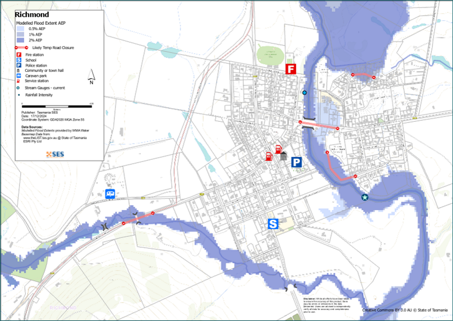
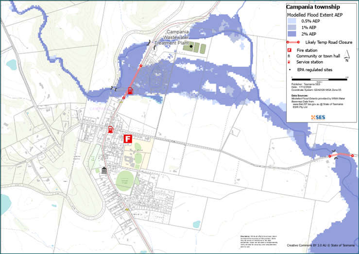
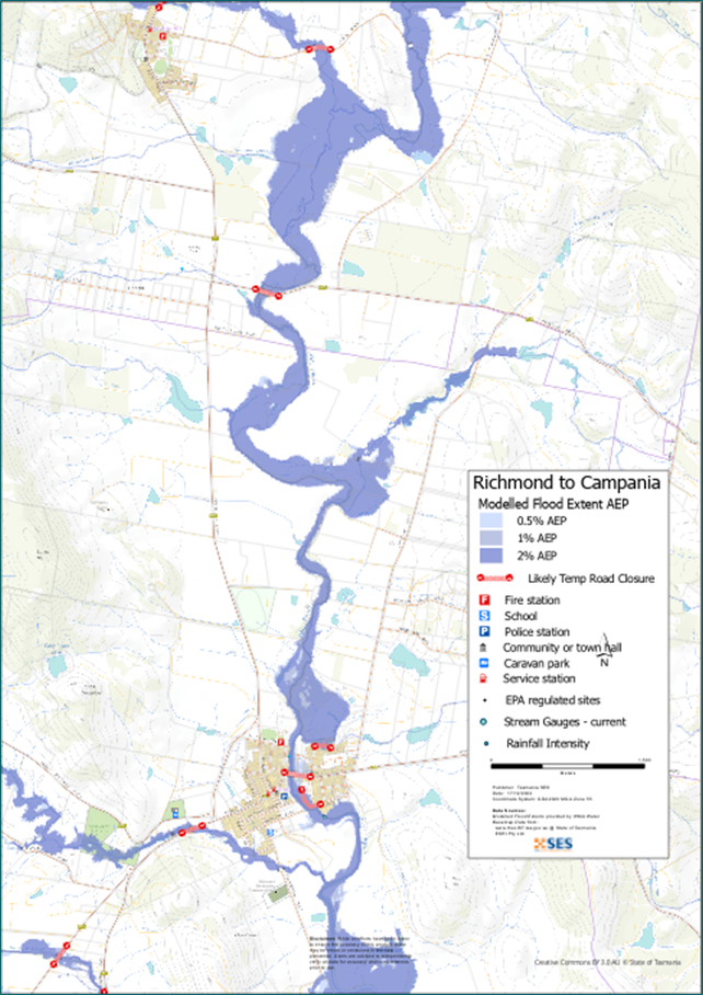
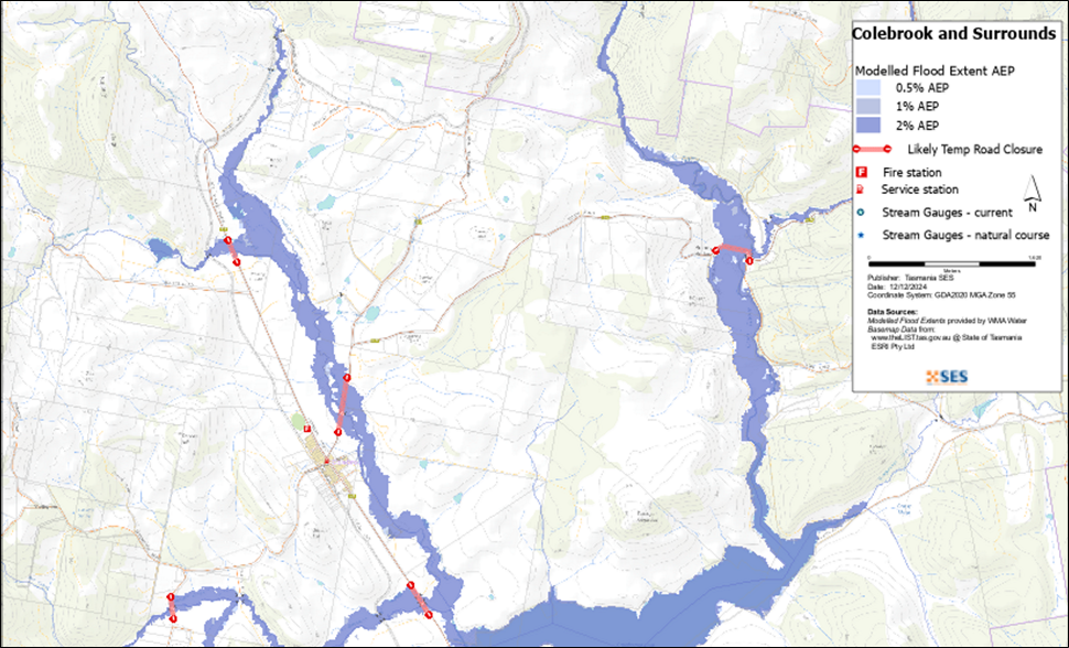
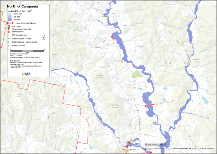
If the Coal River has a major flood, parts of Richmond may flood, including homes. Native Hut Rivulet may also flood parts of Campania, mostly in the north of the town. Agricultural land will flood and bridges and there may be water over bridges and roads.
Flash flooding can also cause local flooding in this area, including in the towns of
- Richmond
- Campania, and
- Colebrook.
Flash flooding is caused directly by heavy rain and is difficult to predict. There may be little or no warning other than forecasts for heavy rain or severe weather.
The maps in this guide show the level of flooding that has a 1% chance of happening any year, this is known as 1% Annual Exceedance Probability (AEP). You are likely to experience flooding such as that shown in the maps in your lifetime. Tasmanians need to prepare for flood events that may not happen often as well as minor flooding they may have experienced.
Even if your home is not inundated, you should prepare for isolation plus potential power and telecommunications outages. Roads in the area may be cut, including
- Colebrook Rd
- Richmond Rd
- Mud Walls Rd
- Fingerpost Rd
- Estate Rd
- Eldon Rd.
Depending on where the rain falls and how heavy it is, other local roads may also be cut. Travel in the area is likely to be difficult or impossible until roads are clear. If you are safe at home or elsewhere, it is usually best you stay where you are until the flooding subsides. If you need to evacuate, you should leave early, before flood waters rise.
收听ABC本地电台936AM收听警告和建议,或访问TasALERT.com。.
您有洪水风险吗?
There have been significant floods in the Coal River in 2011, 2009, 1993 and 1986. Parts of this area were flooded in the well known 1929 flood event, and in 1960 it’s said that the river reached the top of the arches on the Richmond Bridge.
我应该怎么做?
- 查看地图,了解您的住宅或商家是否可能发生洪水。.
- 评估您的住宅或企业,并做好准备以最大程度地减少潜在的洪水损害。.
- 洪水期间,检查您是否能够安全地到达家、工作地点或学校。.
- 准备家庭应急计划。考虑是否需要在洪水来临前撤离。参见 做好应急准备– 个人和家庭应急准备指南。.
- 如果你是初级生产者, 农场防洪应急包 为洪水提供准备建议,以帮助保护您的企业和库存。.
- If you run a business or other organisation, check out the Tasmanian Government’s Emergency Ready Business tool online
- 如果您可能被隔离并且必须获得服务,您可能需要提早撤离。.
- 如果您在易发洪灾的地区露营,请务必随时了解情况,如果可能发生洪水,请及早转移到高地。.
像地图上显示的洪水,或者更糟糕的情况,将会再次发生。没有两次洪水是相同的。.
如果您住在低洼地区或靠近水道,您的房屋可能会被淹没。即使您的家是安全的,您也可能需要绕过洪水地区,或者您的道路通行可能会受到阻碍。切勿驾车进入或进入洪水区域。道路和桥梁可能被冲毁或不安全。请避免在洪水期间出行。.
了解该怎么做可以拯救你的生命并帮助保护你的财产。制定家庭应急计划是准备工作的最佳方法之一。决定天气和降雨触发条件,以便知道何时采取行动。.
澳大利亚气象局天气预报、警告和观测
该局发布 特大暴雨预警,恶劣天气预警和/或雷暴预警,可能导致山洪暴发 每当 大雨 预计在一个地区。警报和暴雨之间的间隔时间可能从一小时到二十四小时或更长。.
Whenever rain that may lead to flooding along the Coal River is expected, the Bureau will issue:
-
- A 洪水观察 – a “heads up” early advice of forecast weather that may lead to flooding
-
- A generalised Flood Warning – giving a prediction of when flooding is likely to develop.
-
- There are no formal flood warning levels for the Coal River or other waterways in this area. Track water levels using the NRE Water Portal. There are four gauges in this area:
-
- Coal River downstream Brown Mountain Road
-
- Coal River upstream White Kangaroo Rivulet
-
- White Kangaroo Rivulet upstream Coal River
-
- Coal River at Richmond
降水观测 at
-
- Colebrook
-
- Tunnack Fire Station
-
- Campania
-
- Richmond and
-
- other nearby rain gauges
can indicate possible flood risks. Given the very short warning times, it is best to act on the predictive BoM warnings rather than wait for any flood alerts during rainfall.
这 库尼亚山雷达 is useful to be aware in real-time where heavy rainfall is falling. Radar Rainfall estimates can also fill in gaps in areas where there are no rainfall stations.
理解警告和关键信息
留意周围发生的事情。定期查看预报、观测和警报。.
 |
建议 (黄色): 事件已发生。无即时危险。请保持关注,以防情况发生变化。. |
 |
观察并行动(橙色): 威胁级别有所提高。情况正在变化,您需要立即开始采取行动来保护您和您的家人 |
 |
紧急警报(红色): 紧急警报是最高级别的警报。您可能面临危险,需要立即采取行动。任何耽搁都可能危及您的生命。. |
 |
社区更新(蓝色): 关于特定事件或事件,受影响社区的具体信息和最新动态。. |
| 事件(白色): 事件是指在成为紧急警报之前的初次发生。一旦报告了事件,TasALERT 就会发布基本信息,包括事件的类型和地点。. |
洪水水位
While no two floods are the same, the following describes what you can expect at different flood levels around the area. Even if your property is not flooded, you need to think about access and services. Different levels of rainfall can cause flooding depending on its intensity, duration, how wet the ground is beforehand and where the rain falls.
轻度洪水
A minor flood can inundate low lying paddocks, orchards and other farmland. Stock should be moved for their safety. There may also be some flooding across some minor roads and parkland areas. In Richmond, minor flooding may begin to inundate low lying streets and properties but would be below floor level.
中度洪水
There is more extensive flooding of agricultural land and some buildings may flood above floor height. Certain streets in Richmond are likely to flood such as
-
- Cosgrove Drive, and
-
- Woodburn Close.
部分房产可能会因小路被淹没而与外界隔绝数小时。.
特大洪灾
There is at least a 2% chance in any year of major flooding that can flood homes and other buildings in parts of
-
- Richmond,
-
- Colebrook,
-
- Campania and
-
- the surrounding areas.
This is known as the Annual Exceedance Probability, or AEP.
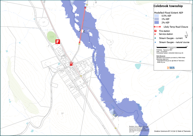
Native Hut Rivulet may flood the northern part of Campania. In Colebrook the main risk is flooded roads from Wallaby Rivulet. In Richmond there are streets that will flood including
-
- Wellington Street
-
- Cosgrove Drive
-
- Woodburn Close, and
-
- St Johns Circle.
This level of flooding could result from about 55-60mm of rain over 6 hours in Richmond, for example. Roads in the flooded areas will be closed, houses may be flooded and surrounding agricultural land will be flooded. This could include infrastructure for electricity, water, phone and internet.
Many major and minor roads will be closed, isolating businesses, houses, farms and towns. There may also be flooding from heavy rainfall that is difficult to predict.
Go to TasALERT.com or listen to ABC local radio for detailed up to date information and advice during heavy rainfall events.
了解风险,做好准备,尽可能降低风险,与他人联系,保持警惕,并安全行事。.
洪水之前
做好应急准备 – 个人和家庭应急准备指南。.
了解您的风险
塔斯马尼亚州经常发生洪水,可能造成广泛而重大的损失。在过去的 200 年里,塔斯马尼亚州有 78 人死于与洪水有关的事故。本指南旨在帮助您了解您所在地区的洪水风险。.
2. 准备您的家庭
制定涵盖风暴和洪水的应急计划
考虑一下在风暴或洪水来临时你会怎么做,这意味着你会有更好的准备,每个人都会更安全。制定一个你的家庭成员都明白的应急计划。有一些清单可以帮助你完善你的计划——请看 做好应急准备 – 个人和家庭应急准备指南。.
定期检查您的计划,并让家中的每一位成员都模拟可能影响您家庭的洪水场景进行演练。.
准备一个应急包
准备好了
- 电池供电的收音机和手电筒,备用电池
- 重要信息,例如您的应急计划
- 紧急电话号码列表
- 食物和水
- 急救箱
- 橡胶或结实的皮革手套
视情况打包
- 保暖衣物、结实的鞋子或靴子
- 药品、眼镜或其他必需品
- 手机和充电器
- 宠物食品以及它们所需的其他任何物品
- 照片和特别的纪念品
- 钱
- 重要文件,例如
-
- 保险单据
-
- 护照和
-
- 出生证明
定期测试收音机和手电筒里的电池。.
3. 尽可能降低洪水风险
- 在购买、维护或开发房产时,请考虑风暴、洪水和其他危险。.
- 修剪或移除您家中、商铺上方或您物业附近电线上方的树木和树枝。.
- 保持雨水槽和排水沟畅通。.
4. 与他人联系
Know your neighbours and get involved in your community. A connected community is a safer and more resilient community in an emergency and can help everyone recover better afterwards. Check that family and neighbours are safe and aware of what’s happening.
于
5. 保持更新
留意周围发生的事情。定期查看预报、观测和警报。.
- 这 气象局 网站.
6. 确保安全
- 看管好孩子。.
- 为应对可能的电力、供水或网络中断做好准备。.
- 检查您的应急包是否已准备好。.
- 避开积水区域,如排水沟。. 永不 在洪水期间徒步、玩耍、骑车或驾车。您无法分辨水下有什么,也无法判断水深或水流速度。在仅 20 厘米的快速流动的水中,很容易被冲走并溺水。洪水可能很危险。.
当地面发生洪水时
- 将家用物品放在高处以最大程度地减少可能的损坏。.
- 如果安全的话,请关闭水电煤气。.
- 一种防止污水倒灌回家的好方法是将沙袋放入塑料袋中,然后用它们堵住马桶、覆盖排水管和水槽。.
- 趁还能安全离开就走。.
如果您需要撤离
- 遵循 SES / 塔斯马尼亚警方 的建议。.
- 带上你的应急包。.
- 去安全地点或避难中心与亲友会合。.
- 让别人知道你去了哪里。.
照顾好您的动物
You are responsible for your animals in an emergency. If you have pets and other animals it will take you longer to evacuate in a flood or other emergency. Move livestock from flood prone areas well before flood waters may rise. For more information see
避免在风暴期间和风暴过后出行
- 不要去观光。游客会延误紧急服务并造成事故。.
- 注意诸如
-
- 路面积水
-
- 受损的电力线
-
- 山体滑坡
-
- 损坏的道路
-
- 倒下的树木或屋面板。.
- 切勿冒险涉水。洪水中的大多数死亡和救援事件都与驾车涉水有关。.
- 在未受洪水影响的路段,请慢行并打开车头灯。.
之后
- 请继续收听 ABC 本地广播电台的最新消息、道路重新开放信息、社区会议等。.
- 如果您离开了家,在紧急事务管理署(SES)或塔斯马尼亚警方告知您可以安全返回之前,请勿回家。.
- 注意道路危险,例如路面上的泥土或碎屑、损坏的道路/桥梁以及正在进行清理和维修的工作人员。.
如果您的房屋遭到损坏
- 在检查损坏时,请留在地面。注意倒下的树木、碎玻璃、松动的屋顶或其他危险。.
- 穿结实的靴子、手套和防护服。.
- 在受洪水影响的建筑物内部,请使用手电筒,切勿使用火柴或蜡烛。.
- 饮用水必须煮沸,直到被告知自来水安全为止。.
- Do not turn on it is tested by a licensed electrician or gas fitter for safety.
- 如果您的房屋受损,需要住到别处,请带上您的应急包和宠物。
- 如果安全,请拍摄任何损坏的照片并联系您的保险公司。.
- 看管好孩子。.
- 检查邻居是否安好。.
欲了解更多信息,请访问 www.ses.tas.gov.au
保持知情和获取更多信息
Current warnings – TasALERT.com
Emergency Broadcasters – 您当地的ABC广播电台
TASSES Social Media – facebook.com/sestasmania
防洪应急准备 ses.tas.gov.au/flood-plan/
全国接力服务 (NRS) relayservice.gov.au
Local Emergency Broadcasters ABC 936AM
Southerm Midlands Council southernmidlands.tas.gov.au 03 6254 5000
Clarence City Council cc.tas.gov.au 03 6217 9500
Mapping Note
本计划中的地图显示了塔斯马尼亚战略洪水测绘 (TSFM) 项目的数据。您可以使用洪水灾害数据图层来探索这些数据,该图层位于 www.thelist.tas.gov.au.
克拉伦斯市议会已为这些地区提供了详细的洪水研究,请参阅 https://www.ccc.tas.gov.au/living/your neighbourhood/flooding/. CCC 数据包括气候变化预测,显示洪水深度较浅,因此洪水范围与下面地图中显示的 TSFM 范围相比,有很大不同,而且通常更大。此数据基于过去的降雨量平均值。.
免责声明
The maps show potential flooding risks from consistent levels of rainfall across catchments, such as a 1% Annual Exceedance Probability (AEP). In flooding events, rainfall is likely to be more inconsistent across a catchment, so these flood maps should be considered indicative only. The mapped areas of flood risk show higher probability of inundation. Other areas have lower probability of flooding, but in severe and rare events (rarer than 1%AEP), other lower areas may be also at risk of inundation.
本指南中的信息在出版日期时是准确的。尽管已尽一切努力确保所提供数据的有效性和准确性,但州应急服务部门不对数据错误或疏漏负责。请参阅标准 塔斯马尼亚州政府版权与免责声明 更多详情.
