拉特罗布及周边地区洪水指南
Riverine flooding information for the lower Mersey River and Kings Creek
Version 1.1 January 2026 – see PDF version
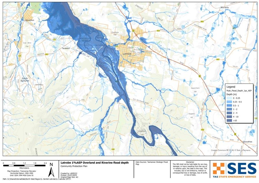
要更详细地查看地图,, 查看塔斯马尼亚战略洪水地图.
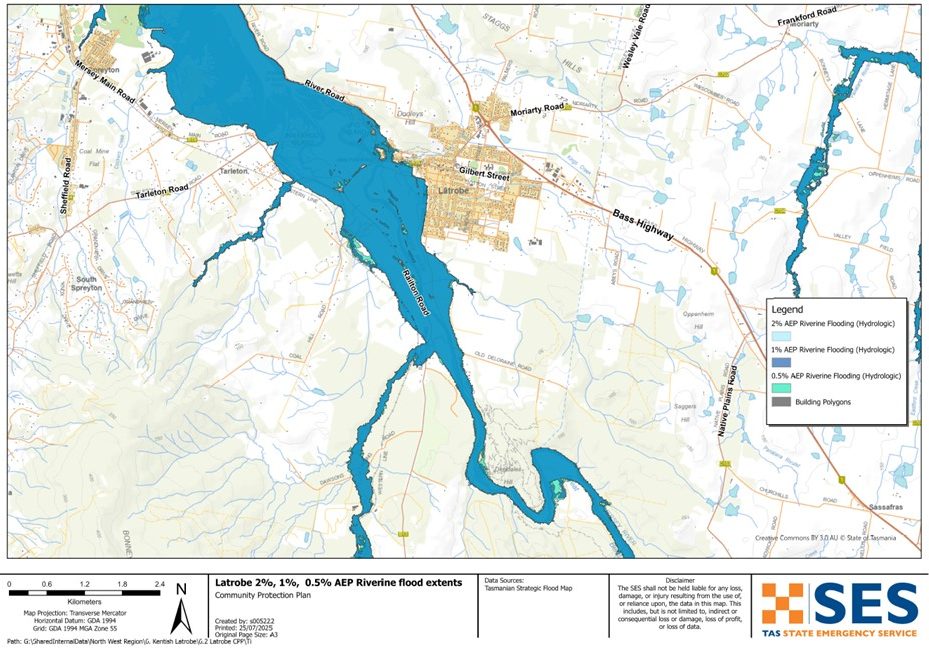
Latrobe and surrounds are likely to be impacted by flooding at the Mersey River and Kings Creek.
- If there is heavy rain upstream in the Mersey River, flood waters may reach and impact Latrobe.
- If there is heavy rain over Latrobe itself, Kings Creek and other stormwater can also cause local flash flooding.
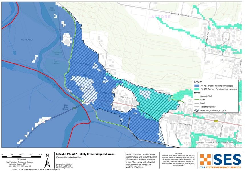
To help reduce flooding in the town, a flood levee and diversion system have recently been built. These are designed to lower the flood risk in parts of Latrobe. Areas inside the levee mitigated areas are expected to flood less often or not as deeply as before.
However, levees are not guaranteed to stop all flooding. SES recommends people evacuate levee protected areas in major flood events. Major flooding could see the levee overtop or fail. Major flooding has a 2% chance (2% Annual Exceedance Probability (AEP) of occurring in any year.
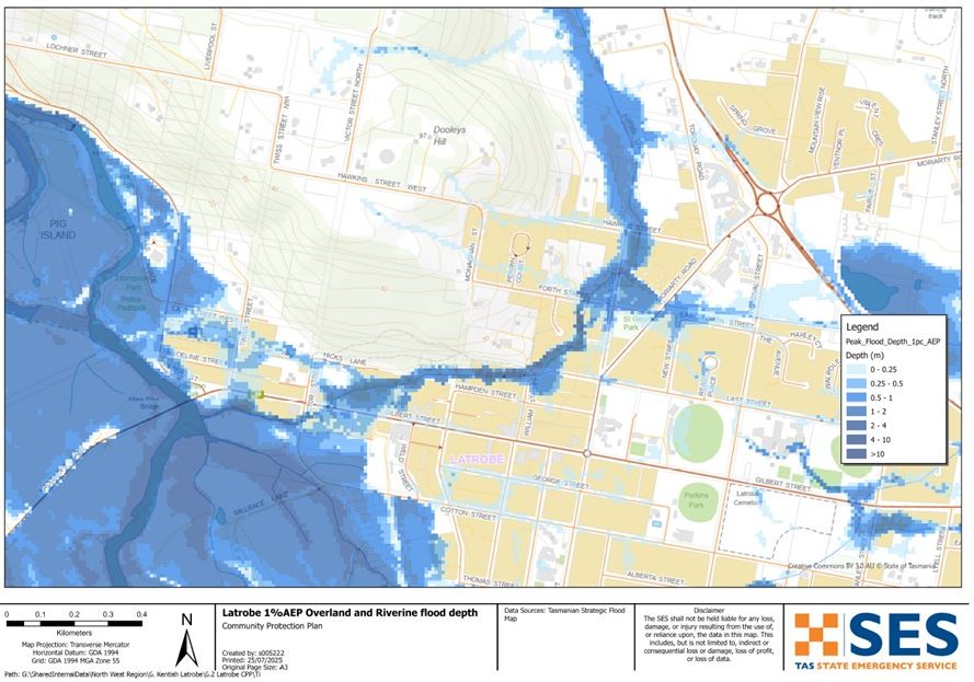
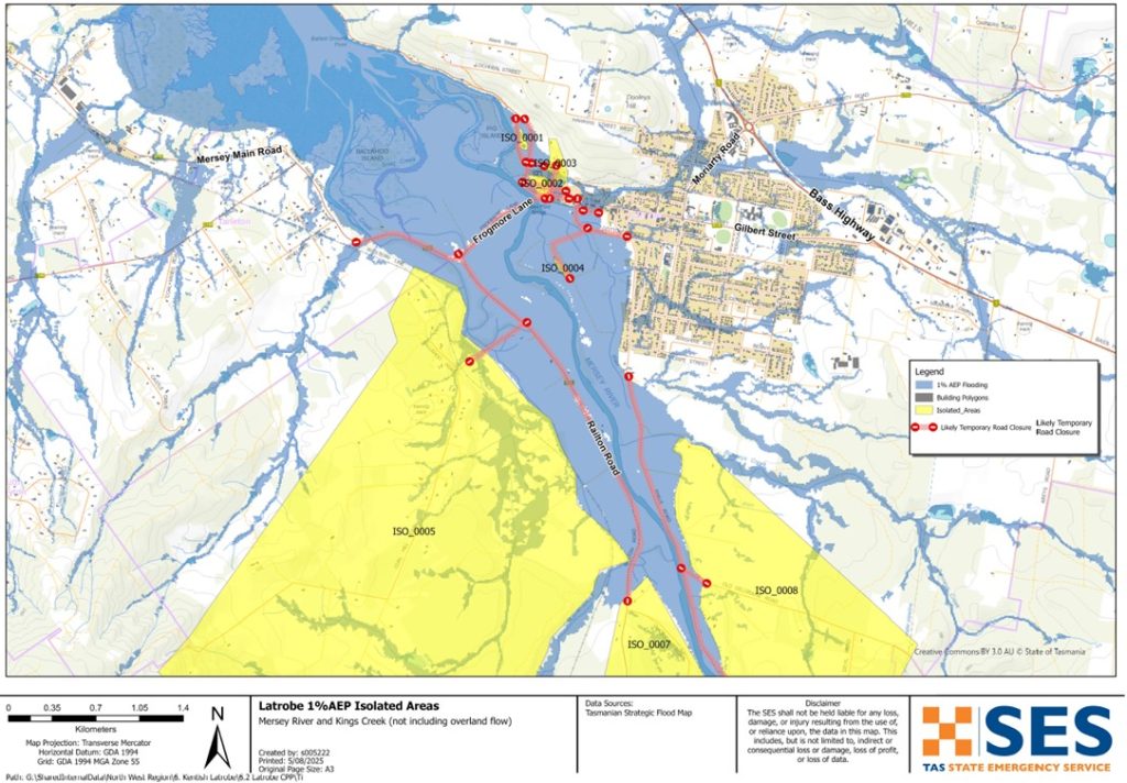
If your property is outside the levee mitigated area, your flood risk has not changed. There is also some uncertainty about how the new infrastructure might affect flooding in other areas nearby. The maps show areas that are likely to be inundated and isolated in a flood.
In a major flood, roads in and around Latrobe will be cut before some areas are flooded. If you need to evacuate, you should leave early, before flood waters rise.
去 www.TasALERT.com 或收听ABC当地电台获取警告和建议。.
洪水可能导致您的住所与外界隔绝数天。即使您的住所没有被淹没,在需要时您也可能无法获得帮助。您应储备至少三天的物资,并为停电和通信中断做好准备。.
您有洪水风险吗?
Past major flooding events around Latrobe since the construction of hydro-electric dams upstream include:
- August 1970 – This major flood was one of the largest recorded floods of the Mersey River and caused extensive inundation and damage to local businesses.
- March 1977 – This flood caused 14 homes to be inundated. Flooding was primarily due to flows in Kings Creek, not the Mersey River, so it occurred with much less warning than usual.
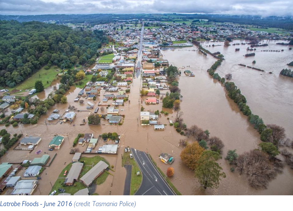
- June 2016 – Highest recorded flood at Latrobe. 121 properties were flooded, and there was significant damage to public infrastructure.
- October 2022 – This flood was similar in scale to the one in 1970, however people were better prepared. Despite widespread inundation, losses were minimised.
Before the dams, there were flooding events in 1884, 1893, 1894, 1923, 1929, 1944 and 1952.
我应该怎么做?
- 查看地图,了解您的住宅或商家是否可能发生洪水。.
- 评估您的住宅或企业,并做好准备以最大程度地减少潜在的洪水损害。.
- 洪水期间,检查您是否能够安全地到达家、工作地点或学校。.
- 准备家庭应急计划。考虑是否需要在洪水来临前撤离。参见 做好应急准备– 个人和家庭应急准备指南。.
- 如果你是初级生产者, 农场防洪应急包 为洪水提供准备建议,以帮助保护您的企业和库存。.
- If you run a business or other organisation, check out the Tasmanian Government’s Emergency Ready Business tool online
- 如果您可能被隔离并且必须获得服务,您可能需要提早撤离。.
- 如果您在易发洪灾的地区露营,请务必随时了解情况,如果可能发生洪水,请及早转移到高地。.
像地图上显示的洪水,或者更糟糕的情况,将会再次发生。没有两次洪水是相同的。.
如果您住在低洼地区或靠近水道,您的房屋可能会被淹没。即使您的家是安全的,您也可能需要绕过洪水地区,或者您的道路通行可能会受到阻碍。切勿驾车进入或进入洪水区域。道路和桥梁可能被冲毁或不安全。请避免在洪水期间出行。.
了解该怎么做可以拯救你的生命并帮助保护你的财产。制定家庭应急计划是准备工作的最佳方法之一。决定天气和降雨触发条件,以便知道何时采取行动。.
澳大利亚气象局天气预报、警告和观测
澳大利亚气象局(气象局)在预计的天气可能在一两天内导致洪水时发布洪水观测预警。洪水观测预警可能:
- be for a specific area such as Latrobe, or
- 并推广到西北河流流域等
The Bureau issues Minor, Moderate and Major flood warnings specifically for the Mersey River, 包括预测的洪水高度。预警和洪水之间可能相隔数小时至一两天。.
降雨监测与观测
River levels and rainfall in the Mersey River catchment (including the Fisher River and Arm River) can be monitored on the Bureau of Meteorology website. Go to www.bom.gov.au/tas/flood/northwestern.shtml
The N.W. Tasmania (West Takone) Radar is useful to be aware of where heavy rainfall is falling. Radar Rainfall estimates can fill in gaps in areas where there are no rainfall stations. Go to: www.bom.gov.au/products/IDR523.loop.shtml .
理解警告和关键信息
留意周围发生的事情。定期查看预报、观测和警报。.
 |
建议 (黄色): 事件已发生。无即时危险。请保持关注,以防情况发生变化。. |
 |
观察并行动(橙色): 威胁级别有所提高。情况正在变化,您需要立即开始采取行动来保护您和您的家人 |
 |
紧急警报(红色): 紧急警报是最高级别的警报。您可能面临危险,需要立即采取行动。任何耽搁都可能危及您的生命。. |
 |
社区更新(蓝色): 关于特定事件或事件,受影响社区的具体信息和最新动态。. |
| 事件(白色): 事件是指在成为紧急警报之前的初次发生。一旦报告了事件,TasALERT 就会发布基本信息,包括事件的类型和地点。. |
Flood levels at Latrobe
While no two flood events are the same, the following table shows what you can expect for different flood levels around Latrobe. Even if your property is not flooded, you should think about access routes.
Minor flood
Rainfall likely to trigger this kind of flooding: 55-110mm/24hrs
River levels: 3.1m to 3.5m @ Mersey Rv at Latrobe Bridge river gauge
Likelihood off occurring in a year (AEP): 50% chance of occurring
Likely flood impacts: Flood water may cover low-lying areas. Farmland surrounding Latrobe is likely to be affected. Farm equipment and livestock in low-lying areas should be moved to higher ground. People living in very low-lying areas in and around Latrobe should be alert and stay informed in case conditions worsen.
中度洪水
Rainfall likely to trigger this kind of flooding: 85-150mm/24hrs
River levels: 3.6m to 3.9m @ Mersey Rv at Latrobe Bridge river gauge
Likelihood off occurring in a year (AEP): 10-20% chance of occurring
Flood impacts
Flood water will cover larger areas of land and enter some homes and other buildings.
Railton Road, Mersey Main Road, Coal Hill Road & Bells Parade may be flooded
In a high moderate flood water may enter houses & businesses in the low-lying areas of the town around:
- Mersey Main Road
- River Road/Twiss Street
- Shale Road
- Tarleton Road and
- Mersey Main Road
特大洪灾
Rainfall likely to trigger this kind of flooding: 85-150mm/24hrs
River levels: 4.0m+ @ Mersey Rv at Latrobe Bridge river gauge
Likelihood off occurring in a year (AEP): 2% chance of occurring
Flood impacts
Widespread flooding may cause significant flooding of homes, businesses and other buildings.
The Mersey River may flood large parts of the town west of the supermarket/Kings Park will likely be inundated.
Flooding from Kings Creek, will likely affected houses in the surrounding area.
Many properties will flood including residences & businesses in::
- Gilbert Street
- Victor Street
- Urquhart Lane
- Twiss Lane
- Twiss Street
- Madeline Street
- Last Street West
- Railton Road
- Shale Road
- Mersey Main Road
- Kobie Lane
Properties in Coal Hill Road, Ballahoo Road, Old Deloraine Road and Devil Road may be isolated for days.
我应该怎么做?
Go to TasALERT.com or listen to ABC local radio for detailed up to date information and advice during heavy rainfall events.
了解风险,做好准备,尽可能降低风险,与他人联系,保持警惕,并安全行事。.
洪水之前
做好应急准备 – 个人和家庭应急准备指南。.
了解您的风险
塔斯马尼亚州经常发生洪水,可能造成广泛而重大的损失。在过去的 200 年里,塔斯马尼亚州有 78 人死于与洪水有关的事故。本指南旨在帮助您了解您所在地区的洪水风险。.
2. 准备您的家庭
制定涵盖风暴和洪水的应急计划
考虑一下在风暴或洪水来临时你会怎么做,这意味着你会有更好的准备,每个人都会更安全。制定一个你的家庭成员都明白的应急计划。有一些清单可以帮助你完善你的计划——请看 做好应急准备 – 个人和家庭应急准备指南。.
定期检查您的计划,并让家中的每一位成员都模拟可能影响您家庭的洪水场景进行演练。.
准备一个应急包
准备好了
- 电池供电的收音机和手电筒,备用电池
- 重要信息,例如您的应急计划
- 紧急电话号码列表
- 食物和水
- 急救箱
- 橡胶或结实的皮革手套
视情况打包
- 保暖衣物、结实的鞋子或靴子
- 药品、眼镜或其他必需品
- 手机和充电器
- 宠物食品以及它们所需的其他任何物品
- 照片和特别的纪念品
- 钱
- 重要文件,例如
-
- 保险单据
-
- 护照和
-
- 出生证明
定期测试收音机和手电筒里的电池。.
3. 尽可能降低洪水风险
- 在购买、维护或开发房产时,请考虑风暴、洪水和其他危险。.
- 修剪或移除您家中、商铺上方或您物业附近电线上方的树木和树枝。.
- 保持雨水槽和排水沟畅通。.
4. 与他人联系
Know your neighbours and get involved in your community. A connected community is a safer and more resilient community in an emergency and can help everyone recover better afterwards. Check that family and neighbours are safe and aware of what’s happening.
于
5. 保持更新
留意周围发生的事情。定期查看预报、观测和警报。.
- 这 气象局 网站.
6. 确保安全
- 看管好孩子。.
- 为应对可能的电力、供水或网络中断做好准备。.
- 检查您的应急包是否已准备好。.
- 避开积水区域,如排水沟。. 永不 在洪水期间徒步、玩耍、骑车或驾车。您无法分辨水下有什么,也无法判断水深或水流速度。在仅 20 厘米的快速流动的水中,很容易被冲走并溺水。洪水可能很危险。.
当地面发生洪水时
- 将家用物品放在高处以最大程度地减少可能的损坏。.
- 如果安全的话,请关闭水电煤气。.
- 一种防止污水倒灌回家的好方法是将沙袋放入塑料袋中,然后用它们堵住马桶、覆盖排水管和水槽。.
- 趁还能安全离开就走。.
如果您需要撤离
- 遵循 SES / 塔斯马尼亚警方 的建议。.
- 带上你的应急包。.
- 去安全地点或避难中心与亲友会合。.
- 让别人知道你去了哪里。.
照顾好您的动物
You are responsible for your animals in an emergency. If you have pets and other animals it will take you longer to evacuate in a flood or other emergency. Move livestock from flood prone areas well before flood waters may rise. For more information see
避免在风暴期间和风暴过后出行
- 不要去观光。游客会延误紧急服务并造成事故。.
- 注意诸如
-
- 路面积水
-
- 受损的电力线
-
- 山体滑坡
-
- 损坏的道路
-
- 倒下的树木或屋面板。.
- 切勿冒险涉水。洪水中的大多数死亡和救援事件都与驾车涉水有关。.
- 在未受洪水影响的路段,请慢行并打开车头灯。.
之后
- 请继续收听 ABC 本地广播电台的最新消息、道路重新开放信息、社区会议等。.
- 如果您离开了家,在紧急事务管理署(SES)或塔斯马尼亚警方告知您可以安全返回之前,请勿回家。.
- 注意道路危险,例如路面上的泥土或碎屑、损坏的道路/桥梁以及正在进行清理和维修的工作人员。.
如果您的房屋遭到损坏
- 在检查损坏时,请留在地面。注意倒下的树木、碎玻璃、松动的屋顶或其他危险。.
- 穿结实的靴子、手套和防护服。.
- 在受洪水影响的建筑物内部,请使用手电筒,切勿使用火柴或蜡烛。.
- 饮用水必须煮沸,直到被告知自来水安全为止。.
- Do not turn on it is tested by a licensed electrician or gas fitter for safety.
- 如果您的房屋受损,需要住到别处,请带上您的应急包和宠物。
- 如果安全,请拍摄任何损坏的照片并联系您的保险公司。.
- 看管好孩子。.
- 检查邻居是否安好。.
欲了解更多信息,请访问 www.ses.tas.gov.au
保持知情和获取更多信息
Current warnings – TasALERT.com
Emergency Broadcasters – 您当地的ABC广播电台
TASSES Social Media – facebook.com/sestasmania
防洪应急准备 ses.tas.gov.au/flood-plan/
全国接力服务 (NRS) relayservice.gov.au
Local Emergency Broadcasters ABC 103.3 FM
Latrobe Council latrobe.tas.gov.au 6426 4444
免责声明
The maps show potential flooding risks from consistent levels of rainfall across catchments, such as a 1% Annual Exceedance Probability (AEP). In flooding events, rainfall is likely to be more inconsistent across a catchment, so these flood maps should be considered indicative only. The mapped areas of flood risk show higher probability of inundation. Other areas have lower probability of flooding, but in severe and rare events (rarer than 1%AEP), other lower areas may be also at risk of inundation.
本指南中的信息在出版日期时是准确的。尽管已尽一切努力确保所提供数据的有效性和准确性,但州应急服务部门不对数据错误或疏漏负责。请参阅标准 塔斯马尼亚州政府版权与免责声明 更多详情.
