霍巴特东岸
盖尔斯顿湾、林迪斯法恩、罗斯湾、罗斯尼、蒙塔古湾、罗斯尼公园、瓦兰、莫宁顿、贝勒里夫、霍华和特兰梅尔郊区沿海淹没、河流和直接降雨洪水信息
DRAFT version 0.1b September 2025 for community input – email ses@ses.tas.gov.au – See PDF version
要更详细地查看地图,, 查看塔斯马尼亚战略洪水地图.
了解您的洪水风险并做好准备
霍巴特东岸的天然水道很少,但有庞大的雨水排水管和涵洞网络,以及广泛的城市发展,这些都会影响洪水泛滥。.
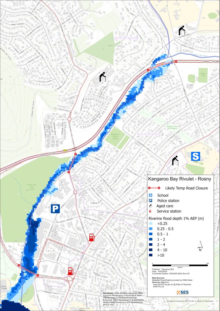
在 Rosny Park 和 Warrane,Kangaroo Bay Rivulet 的一次大洪水可能会淹没房产、道路和 Eastlands 购物中心。在 Geilston Bay,Faggs Gully Creek 的洪水可能会切断
- 盖尔斯顿湾路,和
- 盖尔斯顿溪路.
本指南中的地图显示了水体及直接降雨引发的洪水,其发生概率为1%(即每年有11%的概率发生)。强降雨可能引发山洪暴发。.
您一生中很可能会经历地图所示的洪水。塔斯马尼亚人需要为不经常发生的洪水事件以及他们可能经历过的轻微洪水做好准备。.
即使您的家中未被淹没,您也应该为隔离以及潜在的电力和电信中断做好准备。塔斯马尼亚公路可能会在沃兰和莫宁顿被切断。根据降雨的地点和雨量大小,,
- 南臂公路
- 罗比路,而且
- 南臂路
也可能无法通行,小路和街道也可能如此。在道路清理干净之前,该地区的出行可能会很困难或根本无法出行。如果您在家中或其他地方安全,最好待在原地直到洪水退去,除非情况紧急。如果您需要撤离,应尽早离开,在洪水上涨之前。.
收听ABC本地广播936AM,获取警报和建议。.
您有洪水风险吗?
该地区曾发生过洪水事件。2011年,强降雨引发了广泛的山洪暴发。沙丘后面的区域,如贝勒里夫海滩和霍拉海滩,经常发生洪水,如《信使报》1953年报道的那样。该地区鲜有河流泛滥的记录。.
欲知更多详情,请访问 www.ccc.tas.gov.au/living/your neighbourhood/flooding/
我应该怎么做?
- 查看地图,了解您的住宅或商家是否可能发生洪水。.
- 评估您的住宅或企业,并做好准备以最大程度地减少潜在的洪水损害。.
- 洪水期间,检查您是否能够安全地到达家、工作地点或学校。.
- 准备家庭应急计划。考虑是否需要在洪水来临前撤离。参见 做好应急准备– 个人和家庭应急准备指南。.
- 如果你是初级生产者, 农场防洪应急包 为洪水提供准备建议,以帮助保护您的企业和库存。.
- If you run a business or other organisation, check out the Tasmanian Government’s Emergency Ready Business tool online
- 如果您可能被隔离并且必须获得服务,您可能需要提早撤离。.
- 如果您在易发洪灾的地区露营,请务必随时了解情况,如果可能发生洪水,请及早转移到高地。.
像地图上显示的洪水,或者更糟糕的情况,将会再次发生。没有两次洪水是相同的。.
如果您住在低洼地区或靠近水道,您的房屋可能会被淹没。即使您的家是安全的,您也可能需要绕过洪水地区,或者您的道路通行可能会受到阻碍。切勿驾车进入或进入洪水区域。道路和桥梁可能被冲毁或不安全。请避免在洪水期间出行。.
了解该怎么做可以拯救你的生命并帮助保护你的财产。制定家庭应急计划是准备工作的最佳方法之一。决定天气和降雨触发条件,以便知道何时采取行动。.
澳大利亚气象局天气预报、警告和观测
该局发布 特大暴雨预警,恶劣天气预警和/或雷暴预警,可能导致山洪暴发 每当 大雨 警告和暴雨发生之间的时间可从一小时到 24 小时或更长时间不等。.
该地区水道没有水位测量站或正式的洪水预警。.
降水观测 在霍巴特机场、霍巴特(埃勒斯利路)及附近其他雨量计可以指示可能的洪水风险。鉴于预警时间非常短,最好依据澳大利亚气象局的预测性警告采取行动,而不是等到降雨期间出现任何洪水警报。.
这 库尼亚山雷达 is useful to be aware in real-time where heavy rainfall is falling. Radar Rainfall estimates can also fill in gaps in areas where there are no rainfall stations.
理解警告和关键信息
留意周围发生的事情。定期查看预报、观测和警报。.
 |
建议 (黄色): 事件已发生。无即时危险。请保持关注,以防情况发生变化。. |
 |
观察并行动(橙色): 威胁级别有所提高。情况正在变化,您需要立即开始采取行动来保护您和您的家人 |
 |
紧急警报(红色): 紧急警报是最高级别的警报。您可能面临危险,需要立即采取行动。任何耽搁都可能危及您的生命。. |
 |
社区更新(蓝色): 关于特定事件或事件,受影响社区的具体信息和最新动态。. |
| 事件(白色): 事件是指在成为紧急警报之前的初次发生。一旦报告了事件,TasALERT 就会发布基本信息,包括事件的类型和地点。. |
洪水水位
虽然没有两次洪水是完全相同的,但以下描述了您在该地区不同洪水等级下可能遇到的情况。即使您的房产没有被淹没,也需要考虑通行问题。不同强度的降雨、降雨持续时间、地面预先的湿润程度以及降雨落点都会导致不同程度的洪水。.
轻度洪水
小规模洪水会淹没低洼的公园、花园、果园和牧场。牲畜和设备应移走。低洼的次要道路可能会发生一些洪水。雨水系统可能堵塞,导致局部地区被淹。.
中度洪水
街道和公园的洪水更为广泛,一些建筑可能会受到高于楼层高度的影响。一些房产可能因次要道路被淹没而与外界隔绝数小时。东兰兹购物中心的停车场可能会开始被淹,沿袋鼠湾溪的房产和运动场可能会被淹。.
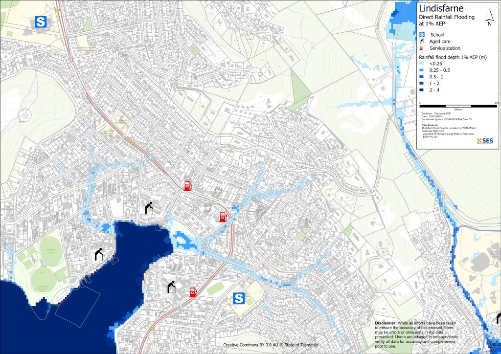
在贝勒里夫海滩和霍巴特海滩附近,可能会发生山洪暴发,尤其是在高潮时。.
特大洪灾
当发生严重洪水时,大片城市和乡村地区将被淹没。许多建筑物——住宅、商业场所和设施——可能会受到水淹影响(高于楼层水平),主要的交通路线将被关闭,并且一些地区将与外界隔绝。.
该地区的主要洪水可能包括:
- 在沃兰和罗斯尼公园,袋鼠湾溪会淹没附近的房产、东兰兹购物中心以及罗斯尼山路以南的体育设施。
- 在贝勒里夫,以及在一定程度上在霍巴特,如果雨水直接落在这些区域,靠近海滩的房产将被淹没
- 盖尔斯顿湾路、罗斯尼山路和塔斯马尼亚公路的部分路段将发生洪水,无法通行。
- 降雨地点和强度不同,其他地区也可能发生洪水。.
Go to TasALERT.com or listen to ABC local radio for detailed up to date information and advice during heavy rainfall events.
了解风险,做好准备,尽可能降低风险,与他人联系,保持警惕,并安全行事。.
洪水之前
做好应急准备 – 个人和家庭应急准备指南。.
了解您的风险
塔斯马尼亚州经常发生洪水,可能造成广泛而重大的损失。在过去的 200 年里,塔斯马尼亚州有 78 人死于与洪水有关的事故。本指南旨在帮助您了解您所在地区的洪水风险。.
2. 准备您的家庭
制定涵盖风暴和洪水的应急计划
考虑一下在风暴或洪水来临时你会怎么做,这意味着你会有更好的准备,每个人都会更安全。制定一个你的家庭成员都明白的应急计划。有一些清单可以帮助你完善你的计划——请看 做好应急准备 – 个人和家庭应急准备指南。.
定期检查您的计划,并让家中的每一位成员都模拟可能影响您家庭的洪水场景进行演练。.
准备一个应急包
准备好了
- 电池供电的收音机和手电筒,备用电池
- 重要信息,例如您的应急计划
- 紧急电话号码列表
- 食物和水
- 急救箱
- 橡胶或结实的皮革手套
视情况打包
- 保暖衣物、结实的鞋子或靴子
- 药品、眼镜或其他必需品
- 手机和充电器
- 宠物食品以及它们所需的其他任何物品
- 照片和特别的纪念品
- 钱
- 重要文件,例如
-
- 保险单据
-
- 护照和
-
- 出生证明
定期测试收音机和手电筒里的电池。.
3. 尽可能降低洪水风险
- 在购买、维护或开发房产时,请考虑风暴、洪水和其他危险。.
- 修剪或移除您家中、商铺上方或您物业附近电线上方的树木和树枝。.
- 保持雨水槽和排水沟畅通。.
4. 与他人联系
Know your neighbours and get involved in your community. A connected community is a safer and more resilient community in an emergency and can help everyone recover better afterwards. Check that family and neighbours are safe and aware of what’s happening.
于
5. 保持更新
留意周围发生的事情。定期查看预报、观测和警报。.
- 这 气象局 网站.
6. 确保安全
- 看管好孩子。.
- 为应对可能的电力、供水或网络中断做好准备。.
- 检查您的应急包是否已准备好。.
- 避开积水区域,如排水沟。. 永不 在洪水期间徒步、玩耍、骑车或驾车。您无法分辨水下有什么,也无法判断水深或水流速度。在仅 20 厘米的快速流动的水中,很容易被冲走并溺水。洪水可能很危险。.
当地面发生洪水时
- 将家用物品放在高处以最大程度地减少可能的损坏。.
- 如果安全的话,请关闭水电煤气。.
- 一种防止污水倒灌回家的好方法是将沙袋放入塑料袋中,然后用它们堵住马桶、覆盖排水管和水槽。.
- 趁还能安全离开就走。.
如果您需要撤离
- 遵循 SES / 塔斯马尼亚警方 的建议。.
- 带上你的应急包。.
- 去安全地点或避难中心与亲友会合。.
- 让别人知道你去了哪里。.
照顾好您的动物
You are responsible for your animals in an emergency. If you have pets and other animals it will take you longer to evacuate in a flood or other emergency. Move livestock from flood prone areas well before flood waters may rise. For more information see
避免在风暴期间和风暴过后出行
- 不要去观光。游客会延误紧急服务并造成事故。.
- 注意诸如
-
- 路面积水
-
- 受损的电力线
-
- 山体滑坡
-
- 损坏的道路
-
- 倒下的树木或屋面板。.
- 切勿冒险涉水。洪水中的大多数死亡和救援事件都与驾车涉水有关。.
- 在未受洪水影响的路段,请慢行并打开车头灯。.
之后
- 请继续收听 ABC 本地广播电台的最新消息、道路重新开放信息、社区会议等。.
- 如果您离开了家,在紧急事务管理署(SES)或塔斯马尼亚警方告知您可以安全返回之前,请勿回家。.
- 注意道路危险,例如路面上的泥土或碎屑、损坏的道路/桥梁以及正在进行清理和维修的工作人员。.
如果您的房屋遭到损坏
- 在检查损坏时,请留在地面。注意倒下的树木、碎玻璃、松动的屋顶或其他危险。.
- 穿结实的靴子、手套和防护服。.
- 在受洪水影响的建筑物内部,请使用手电筒,切勿使用火柴或蜡烛。.
- 饮用水必须煮沸,直到被告知自来水安全为止。.
- Do not turn on it is tested by a licensed electrician or gas fitter for safety.
- 如果您的房屋受损,需要住到别处,请带上您的应急包和宠物。
- 如果安全,请拍摄任何损坏的照片并联系您的保险公司。.
- 看管好孩子。.
- 检查邻居是否安好。.
欲了解更多信息,请访问 www.ses.tas.gov.au
保持知情和获取更多信息
Current warnings – TasALERT.com
Emergency Broadcasters – 您当地的ABC广播电台
TASSES Social Media – facebook.com/sestasmania
防洪应急准备 ses.tas.gov.au/flood-plan/
全国接力服务 (NRS) relayservice.gov.au
Local Emergency Broadcasters ABC 936AM
Clarence City Council ccc.tas.gov.au clarence@ccc.tas.gov.au 6217 9500
请注意
本计划中的地图显示了塔斯马尼亚战略洪水测绘 (TSFM) 项目的数据。您可以使用洪水灾害数据图层来探索这些数据,该图层位于 www.thelist.tas.gov.au.
克拉伦斯市议会已为这些地区提供了详细的洪水研究,请参阅 https://www.ccc.tas.gov.au/living/your neighbourhood/flooding/. CCC 数据包括气候变化预测,显示洪水深度较浅,因此洪水范围与下面地图中显示的 TSFM 范围相比,有很大不同,而且通常更大。此数据基于过去的降雨量平均值。.
免责声明
The maps show potential flooding risks from consistent levels of rainfall across catchments, such as a 1% Annual Exceedance Probability (AEP). In flooding events, rainfall is likely to be more inconsistent across a catchment, so these flood maps should be considered indicative only. The mapped areas of flood risk show higher probability of inundation. Other areas have lower probability of flooding, but in severe and rare events (rarer than 1%AEP), other lower areas may be also at risk of inundation.
本指南中的信息在出版日期时是准确的。尽管已尽一切努力确保所提供数据的有效性和准确性,但州应急服务部门不对数据错误或疏漏负责。请参阅标准 塔斯马尼亚州政府版权与免责声明 更多详情.
