St Marys community flood guide
Riverine and flash flooding information for Newmans Creek, St Patricks Creek, and St Marys Rivulet at St Marys
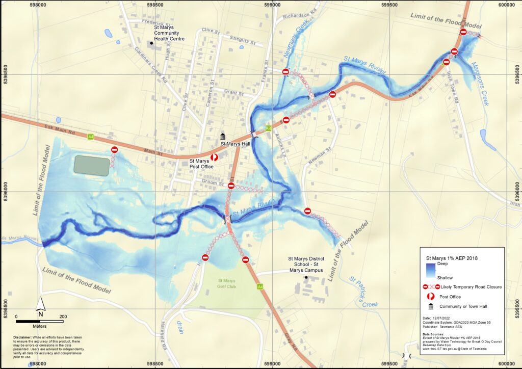
St Marys is subject to flash flooding from St Marys Rivulet and its tributaries, particularly Newmans Creek and St Patricks Creek. The map shows the expected 1% Annual Exceedance Probability (AEP) Flood level in St Marys. You are likely to experience a flood of this size in your lifetime.
In a major flooding event, roads in and around St Marys are likely to be cut and some areas inundated. If you need to evacuate, you should leave early, before flood waters rise. Note the school in the area may become isolated due to flood waters. Listen to ABC local radio for warnings and advice.
In such flooding events, the St Marys area may be isolated due to flooding of the Esk Main Road, Main Street and Story Street. Minor roads may also be cut by flooding, landslips or fallen trees. It is dangerous to drive through flooded roads, particularly in isolated areas.
Even if your home is not inundated, you may be isolated for several days before flood waters recede. You should have supplies for up to three days and be prepared for power and telecommunications outages. Note if you are isolated, you may not be able to access medical or other help if needed.
Are you at risk of flood?
- St Marys has a long history of significant flooding, including in 1926,1929 and 2010.
- A series of floods during 2016, with a major flooding event in January and further significant flood events occurring in June and November.
What should I do?
- Check the map to see whether your home or business is likely to be at risk during a flood.
- Check if you might not be able to safely get to your home, work, or school during a flood.
- Prepare a Home Emergency Plan. Consider if you need to evacuate before a flood.
- Assess your home or business and prepare it to minimise possible flood damage.
Bureau of Meteorology Forecasts, Warnings, and Observations
The Bureau of Meteorology (the Bureau) issues a Flood Watch when predicted weather might cause floods in one or two days. A Flood Watch may
- be for a specific area such as St Marys, or
- be generalised such as for North-East river basins or East Coast forecast district.
The Bureau issues a Severe Weather Warning for very heavy rain that may lead to flash flooding whenever this weather is occurring or is expected in an area. The amount of time between the warning and the arrival of the heavy rain can vary from an hour to 24 hours or sometimes more.
Neither the Bureau nor SES issue Flood Warnings with specific flood heights for the St Marys Rivulet as there is no flood gauge within the catchment to provide warnings of flood heights.
The Break O’Day Council has a Flash Flood Warning System that issues warnings of expected flash flooding events from monitored rainfall stationswithin the catchment area (at Gray and St Patricks Head). The system issues SMS text or email alerts for:
- 5% AEP flood event – a “Moderate” Flood event
- 1% AEP flood event – a “Major” Flood event
- Conditions Easing.
No two floods are the same. Floods like the one shown in the map or worse will occur again.
If you live in a low-lying area you may be at risk of flooding. Even if your home is safe, you may need to detour around flooded areas. Never drive through or enter flood waters.
Knowing what to do can save your life and help protect your property. Preparing a Home Emergency Plan is one of the best ways to prepare.
Include weather and rainfall triggers for action in your Home Emergency Plan.
Flood levels at St Marys
While no two floods are the same, the following table shows what you can expect at different flood levels around St Marys. Even if your property is not flooded, you need to think about access routes.
A minor flood means:
- River channels may fill and spill over into some low-lying areas.
- Wombat Walk and the Bicycle Park at Groom Street, areas can be inundated.
- Flood waters do not reach building floor levels but may impact some buildings below floor level.
- Livestock should be moved from low lying land.
- Main Street near The Flat intersection and The Flat near the St Marys Rivulet bridge starts to have shallow water over the roadways.
A moderate flood means:
- Spill over riverbanks and cover larger areas of land, impacting some homes and other buildings.
- Gray and Harefield Roads start to have shallow water over the roadways.
- Shallow water depths around impacted properties, above floor level flooding of residences is unlikely.
- Areas may be isolated from the town such as:
• Harefield Road
• Gray Road
• St Marys School
• Properties along The Flat
Stock downstream of Story Street may need to be moved. - Close traffic routes such as:
• Story Street through to Harefield and Gray Roads, and to Elephant Pass Road.
• Main Street near the intersection with The Flat.
• The Flat.
A major flood means:
- Widespread flooding isolating St Marys, plus significant flooding of homes and other buildings.
- Overtopping of the bridge on the Esk Main Road near the Irish Town Road intersection.
- More buildings inundated, above floor level flooding of some residences.
There may be utility outages (power, water, sewerage etc). - Residences within inundation areas along Main Street, Story Street, Groom Street, Aulichs Lane and The Flat should be evacuated.
Residents of Irish Town Road may become isolated. - Closed major roads:
• Access to the town from the south, east and west likely to be closed.
• Residents to the east of the bridge over St Marys Rivulet on Main Street may become isolated.
Know your risk, get ready, reduce risk where you can, connect with others, stay alert and act safe.
Before a flood
1. Know your risk
Flooding often happens in Tasmania and can cause widespread and significant damage. In the past 200 years there have been 78 flood related deaths in Tasmania. This guide is to help you understand flood risk in your area.
2. Prepare your household
Have an emergency plan that covers storms and floods
Thinking about what you would do in a storm or flood means you are more prepared and everyone is safer. Have an emergency plan that everyone in your household understands. There are checklists to help you think through your plan – see the SES website or Red Cross Rediplan.
Check your plan regularly and test it by everyone in the household thinking through a flooding scenario that may affect your household.
Prepare an Emergency Kit
Ready to Go
Battery powered radio and torch, spare batteries
Important information, such as your emergency plan
A list of emergency numbers
Food and water
First aid kit
Rubber or strong leather gloves
Pack when needed
Warm clothes, sturdy shoes or boots
Medicine, glasses or other essential items
Mobile phone and phone charger
Pet food and anything else they need
Photos and special keepsakes
Important documents, for example
– insurance papers
– passports and
– birth certificates
Regularly test batteries in radios and torches.
3. Reduce your risk from flooding where you can
- Think about storms, flooding and other hazards when buying, maintaining or developing property.
- Trim or remove trees and branches overhanging your home, business or near powerlines on your property.
- Keep your gutters and drains clear.
4. Connect with others
Know your neighbours and get involved in your community. A connected community is a safer and more resilient community in an emergency and can help everyone recover better afterwards. Check that family and neighbours are safe and aware of what’s happening.
During
5. Keep up to date
Keep aware of what is happening around you. Check forecasts, observations and warnings regularly.
- Tasalert – alert.tas.gov.au
- your local ABC radio station or
- the Bureau of Meteorology’s website.
Understand the warnings and key information
 | Advice (Yellow): an incident has started. There is no immediate danger. Stay up to date in case the situation changes. |
 | Watch and Act (Orange): There is a heightened level of threat. Conditions are changing and you need to start taking action now to protect you and your family |
 | Emergency Warning (Red): An Emergency Warning is the highest level of warning. You may be in danger and need to take action immediately. Any delay now puts your life at risk. |
 | Community update (Blue): Specific information and updates for affected communities regarding a particular event or incident. |
| Incident (White): an incident is the initial occurrence of an event before it becomes an emergency warning. As soon as an incident is reported, TasALERT published basic information including the type and location of incident. |
6. Act Safe
- Supervise children.
- Prepare for possible power, water or internet outages.
- Check your emergency kit is ready to go.
- Keep clear of flooded areas such as drains. NEVER walk, play, ride or drive in floodwater. You can’t always see what is under the water or how deep or fast-moving the water is. It is easy to be swept away and drown in as little as 20cm of fast-moving water. Flood water can be dangerous.
When your home may be flooded
- Put household items up high to minimise possible damage.
- Turn off the electricity and gas if it is safe to do so.
- A great way to stop sewerage flowing back into your home is to place sandbags inside plastic bags and use them to block toilets and cover drains and sinks.
- Leave while you can get out safely.
If you need to evacuate
- Follow the advice from SES / Tasmania Police.
- Take your emergency kit.
- Go to friends or family in a safer place or an evacuation centre.
- Let others know where you have gone.
Look after your animals
You are responsible for your animals in an emergency. If you have pets and other animals it will take you longer to evacuate in a flood or other emergency. Move livestock from flood prone areas well before flood waters may rise. For more information see
- RSPCA’s guidance on preparing for animals in an emergency
- Huon Valley Council’s advice on preparing an emergency pet plan
- the Primary producer farm flood readiness toolkit
Avoid travelling during and after storms
- Do not go sightseeing. Sightseers delay emergency services and cause accidents.
- Watch out for hazards such as
- water over roads
- damaged powerlines
- landslides
- damaged roads
- falling trees or roofing iron.
- Never drive through flood waters. Most deaths and rescues in floods are from people driving through flood waters.
- Drive slowly and turn your headlights on roads not affected by flood waters.
After
- Keep listening for ABC Local Radio updates, road re-openings, community meetings, etc.
- If you left your home, do not return home until SES or Tasmania Police tell you it is safe to do so.
- Be aware of road hazards, such as mud or debris on the road, damaged roads/bridges and crews working on clean-up and repairs.
If your home has been damaged
- Stay at ground level while checking for damage. Be careful of fallen trees, broken glass, loose roofing or other hazards.
- Wear strong boots, gloves and protective clothes.
- Use a torch, never use matches or candles inside flood affected buildings.
- Boil all drinking water until you are told the tap water is safe again.
- Do not turn on it is tested by a licensed electrician or gas fitter for safety.
- If your home is damaged and you need to stay somewhere else, take your emergency kit and pets with you
- Take photos of any damage if safe for you to do so and contact your insurance company.
- Supervise children.
- Check neighbours are okay.
For further information go to www.ses.tas.gov.au
Staying informed and further information
Current warnings (TasAlerts) alerts.tas.gov.au
Bureau of Meteorology (BoM) bom.gov.au/tas/warnings
Emergency Broadcasters ABC 936AM
TAS SES Social Media
facebook.com/sestasmania
twitter.com/sestasmania
SES – Preparing for Flood Emergencies