Riverine flooding information for the Leven River
Version 1.0 September 2023
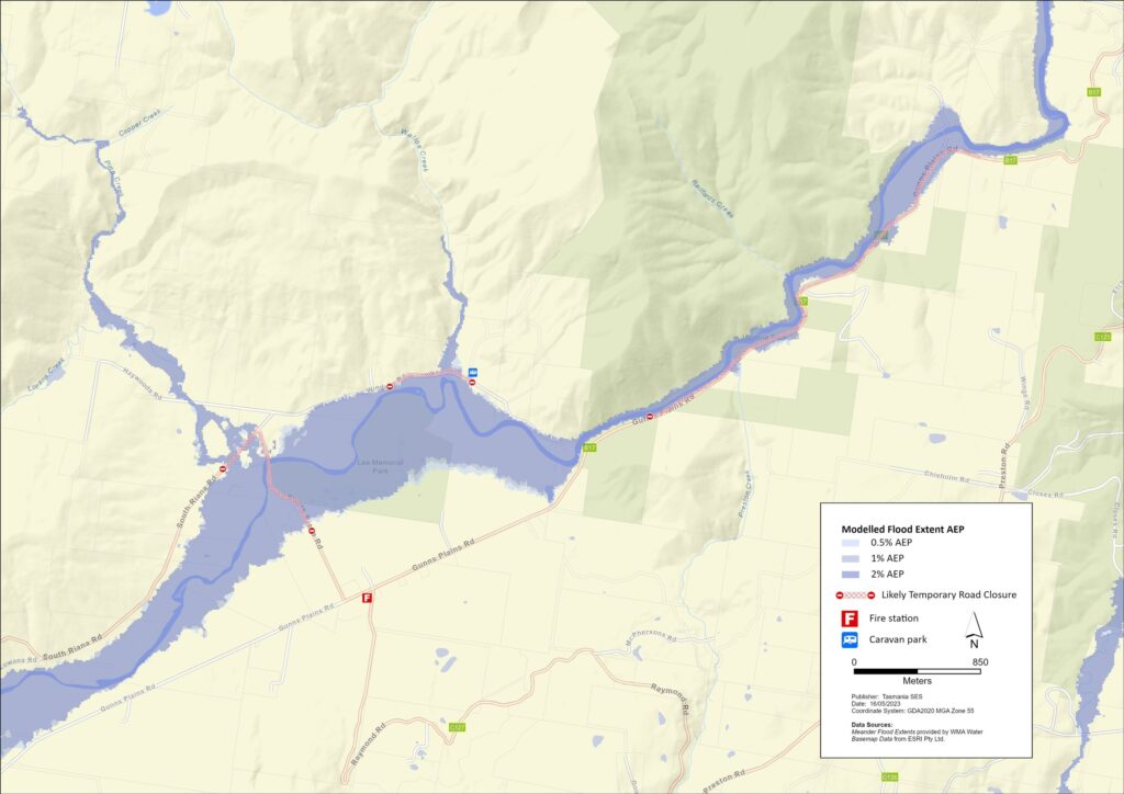
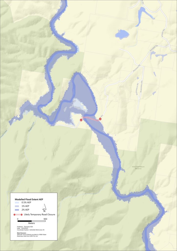
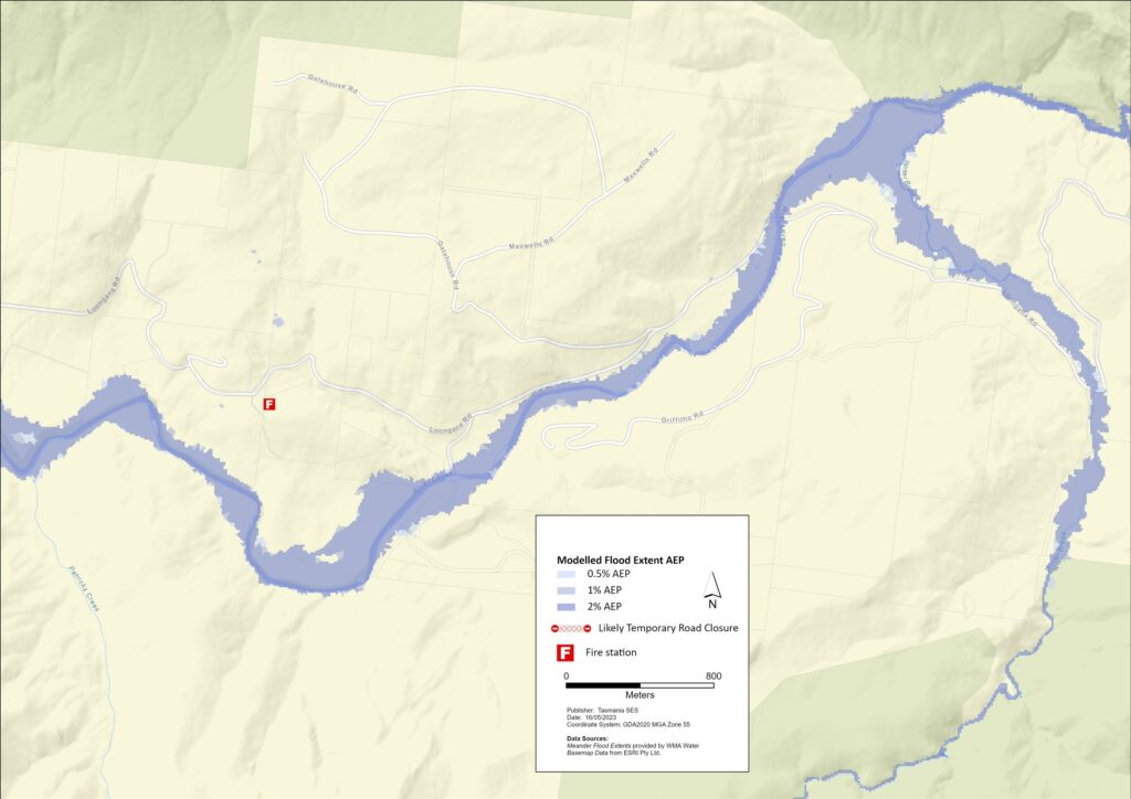
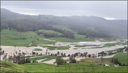
The Leven River can cause flooding in and around Gunns Plains, Loongana & Foggs (Purtons) Flats. The maps show where a flood is likely to reach. The darker blue areas are the most likely to flood.
An extensive network of underground caves and streams exists in Gunns Plains & Loongana. Flooding in these streams can cause sinkholes to appear unexpectedly, or underground flood water can make it to the surface and cause damage in areas not usually prone to flooding.
In a major flood, roads in and around Gunns Plains and Loongana will be cut before some areas are flooded. If you need to evacuate, you should leave early, before flood waters rise. Go to www.tasalert.com or listen to ABC local radio for warnings and advice.
Flood waters may isolate your home for several days. Even if your home is not flooded, you may not be able to access help if needed. You should have supplies for at least three days and prepare for power and telecommunications outages.
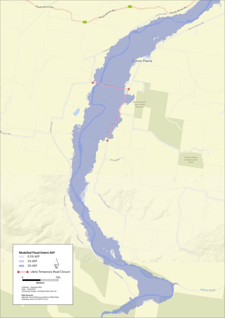
Are you at risk of flood?
Past recent flooding events around Gunns Plains and Loongana include:
- January 2011 – This flood was unusual in that it occurred in summer and due to rainfall mostly in the mid to lower catchment, catching many by surprise. Severe damage was caused through Gunns Plains and 2 significant bridges over the Leven River were washed away. Some residents were isolated for weeks.
- June 2016 – Highest recorded flood in the Leven River. Some businesses were flooded, and there was significant damage to public infrastructure including roads and bridges.
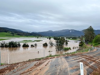
- October 2022 –Severe damage occurred to some businesses as well as roads and other infrastructure. Bridge damage and several landslips around Gunns Plains and Loongana caused extended road closures and some residents to be isolated for many days.
- June 2023 – With as little as 80mm of rain falling overnight, Marshalls Road and South Riana Road were inundated. Wings Wildlife Park was isolated and some cattle in Gunns Plains were surrounded by floodwater and may have been lost if the floodwater had risen further.
What should I do?
- Check the map to see whether your home or business could flood or be isolated.
- Check if you can safely get to your home, work, or school during a flood.
- Prepare a Home Emergency Plan.
- If you are a primary producer, the Farm Flood Readiness Kit provides advice on preparing for a flood to help protect your
- If you will be isolated you may need to evacuate early.
- Assess your home or business and prepare it to minimise possible flood damage.
- If you are camping in a flood prone area, make sure you stay informed and move to higher ground early if a flood is likely.
Floods like the one shown in the map or worse will occur again. No two floods are the same.
If you live in a low-lying area, your house may flood. Even if your home is safe, you may need to detour around flooded areas or your road access may be cut. Never drive into or enter flood waters. Roads and bridges may be washed out or unsafe.
Knowing what to do can save your life and help protect your property. Having a Home Emergency Plan is one of the best ways to prepare. Decide on weather and rainfall triggers for when to act.
Forecasts, Warnings, and Observations
The Bureau of Meteorology (the Bureau) issues a Flood Watch when predicted weather might cause floods in one or two days. A Flood Watch may:
- be for a specific area such as Gunns Plains, or
- be generalised such as for north-west river basins
The Bureau of Meteorology does not provide a specific flood warning for the Leven River.
Rainfall Monitoring and Observations
Whilst the Leven River catchment has no sub-daily Bureau of Meteorology rainfall stations, rainfall in surrounding areas can provide a good idea of what rain is falling in the upper catchment of the Leven River. Rainfall at Lake Gardiner and Waratah can be monitored on the Hydro Tasmania website. Rainfall at Sheffield can be monitored on the Bureau website.
The N.W. Tasmania (West Takone) Radar is useful to be aware of where heavy rainfall is falling. Radar Rainfall estimates can fill in gaps in areas where there are no rainfall stations. Go to: http://www.bom.gov.au/products/IDR523.loop.shtml
Understand the warnings and key information
Keep aware of what is happening around you. Check forecasts, observations and warnings regularly.
- TasALERT.com
- your local ABC radio station or
- the Bureau of Meteorology’s website.
SES will issue flood warnings on tasalert.com based on forecasts from the Bureau in line with the Australian Warning System.
 | Advice (Yellow): an incident has started. There is no immediate danger. Stay up to date in case the situation changes. |
 | Watch and Act (Orange): There is a heightened level of threat. Conditions are changing and you need to start taking action now to protect you and your family |
 | Emergency Warning (Red): An Emergency Warning is the highest level of warning. You may be in danger and need to take action immediately. Any delay now puts your life at risk. |
 | Community update (Blue): Specific information and updates for affected communities regarding a particular event or incident. |
| Incident (White): an incident is the initial occurrence of an event before it becomes an emergency warning. As soon as an incident is reported, TasALERT published basic information including the type and location of incident. |
Know your risk, get ready, reduce risk where you can, connect with others, stay alert and act safe.
Before a flood
1. Know your risk
Flooding often happens in Tasmania and can cause widespread and significant damage. In the past 200 years there have been 78 flood related deaths in Tasmania. This guide is to help you understand flood risk in your area.
2. Prepare your household
Have an emergency plan that covers storms and floods
Thinking about what you would do in a storm or flood means you are more prepared and everyone is safer. Have an emergency plan that everyone in your household understands. There are checklists to help you think through your plan – see the SES website or Red Cross Rediplan.
Check your plan regularly and test it by everyone in the household thinking through a flooding scenario that may affect your household.
Prepare an Emergency Kit
Ready to Go
Battery powered radio and torch, spare batteries
Important information, such as your emergency plan
A list of emergency numbers
Food and water
First aid kit
Rubber or strong leather gloves
Pack when needed
Warm clothes, sturdy shoes or boots
Medicine, glasses or other essential items
Mobile phone and phone charger
Pet food and anything else they need
Photos and special keepsakes
Important documents, for example
– insurance papers
– passports and
– birth certificates
Regularly test batteries in radios and torches.
3. Reduce your risk from flooding where you can
- Think about storms, flooding and other hazards when buying, maintaining or developing property.
- Trim or remove trees and branches overhanging your home, business or near powerlines on your property.
- Keep your gutters and drains clear.
4. Connect with others
Know your neighbours and get involved in your community. A connected community is a safer and more resilient community in an emergency and can help everyone recover better afterwards. Check that family and neighbours are safe and aware of what’s happening.
During
5. Keep up to date
Keep aware of what is happening around you. Check forecasts, observations and warnings regularly.
- www.TasALERT.gov.au
- your local ABC radio station or
- the Bureau of Meteorology’s website.
6. Act Safe
- Supervise children.
- Prepare for possible power, water or internet outages.
- Check your emergency kit is ready to go.
- Keep clear of flooded areas such as drains. NEVER walk, play, ride or drive in floodwater. You can’t always see what is under the water or how deep or fast-moving the water is. It is easy to be swept away and drown in as little as 20cm of fast-moving water. Flood water can be dangerous.
When your home may be flooded
- Put household items up high to minimise possible damage.
- Turn off the electricity and gas if it is safe to do so.
- A great way to stop sewerage flowing back into your home is to place sandbags inside plastic bags and use them to block toilets and cover drains and sinks.
- Leave while you can get out safely.
If you need to evacuate
- Follow the advice from SES / Tasmania Police.
- Take your emergency kit.
- Go to friends or family in a safer place or an evacuation centre.
- Let others know where you have gone.
Look after your animals
You are responsible for your animals in an emergency. If you have pets and other animals it will take you longer to evacuate in a flood or other emergency. Move livestock from flood prone areas well before flood waters may rise. For more information see
- RSPCA’s guidance on preparing for animals in an emergency
- Huon Valley Council’s advice on preparing an emergency pet plan
- City of Hobart’s advice on Pet Management and Emergencies
Avoid travelling during and after storms
- Do not go sightseeing. Sightseers delay emergency services and cause accidents.
- Watch out for hazards such as
- water over roads
- damaged powerlines
- landslides
- damaged roads
- falling trees or roofing iron.
- Never drive through flood waters. Most deaths and rescues in floods are from people driving through flood waters.
- Drive slowly and turn your headlights on roads not affected by flood waters.
After
- Keep listening for ABC Local Radio updates, road re-openings, community meetings, etc.
- If you left your home, do not return home until SES or Tasmania Police tell you it is safe to do so.
- Be aware of road hazards, such as mud or debris on the road, damaged roads/bridges and crews working on clean-up and repairs.
If your home has been damaged
- Stay at ground level while checking for damage. Be careful of fallen trees, broken glass, loose roofing or other hazards.
- Wear strong boots, gloves and protective clothes.
- Use a torch, never use matches or candles inside flood affected buildings.
- Boil all drinking water until you are told the tap water is safe again.
- Do not turn on it is tested by a licensed electrician or gas fitter for safety.
- If your home is damaged and you need to stay somewhere else, take your emergency kit and pets with you
- Take photos of any damage if safe for you to do so and contact your insurance company.
- Supervise children.
- Check neighbours are okay.
For further information go to www.ses.tas.gov.au
Staying informed and further information
Current warnings (TasAlerts) alerts.tas.gov.au
Bureau of Meteorology bom.gov.au/tas/warnings
Emergency Broadcasters ABC 936AM
TAS SES Social Media
- facebook.com/sestasmania
- twitter.com/sestasmania
SES – Preparing for Flood Emergencies
Central Coast Council 6429 8900 (or after hours 6429 8999 for emergencies only)