Geeveston Flood Guide
Riverine flooding information for the Kermandie River
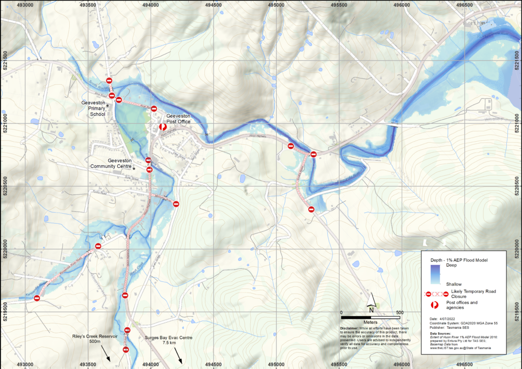
The Kermandie River, Rileys Creek and Scotts Rivulet can cause flooding in Geeveston. The map shows where a flood may reach. The darker blue areas are the most likely to flood.
In a major flood, roads in and around Geeveston will be cut before some areas are flooded. Schools in the area may become isolated due to flood waters. If you need to evacuate, you should leave early, before flood waters rise. Listen to ABC local radio for warnings and advice.
Flooding near Franklin and along the Huon River can also isolate areas around Geeveston. Backroads may be cut by floodwater, landslips or fallen trees, making it dangerous to drive in isolated areas.
Flood waters may isolate your home for several days. Even if your home is not flooded, you may not be able to access help if needed. You should have supplies for at least three days and prepare for power and telecommunications outages.
Are you at risk of flood?
Past flooding events around Geeveston include:
- In December 1995 houses were flooded in Arve Road. The Huon Highway was cut at the junction of Scott’s Road, isolating Geeveston and communities further south. There was further flooding in early 1996.
- In 1947, high rainfall isolated Geeveston for four days from 16-19 June.
Extensive willow and debris removal since the late 1990s has reduced flood risks around Geeveston. However, parts of the township are at risk of being inundated, and extensive areas can become isolated due to flood waters cutting access routes around Geeveston plus surrounding areas.
What should I do?
- Check the map to see whether your home or business could flood.
- Check if you can safely get to your home, work, or school during a flood.
- Prepare a Home Emergency Plan.
- If you will be isolated you may need to evacuate early.
- Assess your home or business and prepare it to minimise possible flood damage.
Floods like the one shown in the map or worse will occur again. No two floods are the same.
If you live in a low-lying area, your house may flood. Even if your home is safe, you may need to detour around flooded areas or your road access may be cut. Never drive into or enter flood waters. Roads and bridges may be washed out or unsafe.
Knowing what to do can save your life and help protect your property. Having a Home Emergency Plan is one of the best ways to prepare. Decide on weather and rainfall triggers for when to act.
Bureau of Meteorology (BoM) Forecasts, Warnings, and Observations
BoM issues a Severe Weather Warning and/or Thunderstorm Warning for heavy rainfall that may lead to flash flooding whenever heavy rain is expected in an area. The time between the warning and heavy rain occurring can vary from an hour to 24 hours or sometimes more.
BoM may issue a Flood Watch when predicted weather might cause floods over the next couple of days. The Flood Watch may include generalized areas when there is a risk of significant rainfall. “Channel Coastal Rivers” is the name of the flood watch area that includes Kermandie/Rileys/Scotts.
BoM do not have a riverine flood warning service for the Kermandie River, Rileys Creek and Scotts Rivulet, . Flood monitoring is also not available, as there not sufficient rainfall and river level gauges within the catchment.
Rainfall Monitoring and Observations
The Mt Koonya Radar is useful for real-time situation awareness of where heavy rainfall is falling. Radar Rainfall estimates are also available to fill in gaps in areas where there are no rainfall stations.
There are no real-time rainfall stations in the Kermandie River catchment. Nearby rainfall stations at Hartz Mountain. Cannells Hills, Dover and Warra may provide useful observations, although rainfall can vary significantly across the area. The Geeveston area is prone to flash flooding from torrential downpours so there may be little warning. Historically intense South-Easterly weather systems have produced the most significant flood events for Geeveston.
Flood levels at Geeveston
While no two flood events are the same, the following table shows what you can expect for different flood levels around Geeveston. Even if your property is not flooded, you need to think about access routes.
A minor flood
- Flood water may cover low-lying areas.
- Heritage Park and Memorial Park, including the campgrounds in those areas can be flooded.
- Flood water may reach some building floor levels and will impact low-lying paths, parks and backyards.
- Low-level bridges and backroads may be flooded, for example, Donnelleys Road, Kermandie River Road, Hankin and Roberts Road, isolated some properties.
- Livestock in potential flood areas should be moved to higher ground.
A moderate flood (10%AEP)
- May be for example because of 96mm in 24 hours or more. may need to be moved.
- Flood water may cover larger areas of land and enter some homes and other buildings.
- The Rileys Creek Bridge, and the Huon Highway Bridge near School Road may be inundated.
- Flood water may enter houses:
- Northside of Arve Road to near Cemetery Rd, plus the bottom end of Fourfoot Road
- East side of Huon Highway between School Road and Kermandie River Road; west-side between School Road and Duke Street
- Memorial Drive and surrounds
- Areas may be isolated such as.
- O’Hallorans Road
- Fourfoot Road and surrounds
- Upper Kermandie Road
- Rileys Creek Road
- Potentially Ford Street and Duke Street
- Livestock in these areas should be moved to higher ground.
A major flood (1%AEP)
- May be for example because of 157mm in 24 hours or more.
- Widespread flooding will isolate Geeveston, and there will be significant flooding of homes and other buildings.
- The bridge on the Huon Highway near Scotts Road will be flooded.
- More buildings are flooded including
- some low-lying buildings in Geeveston centre
- Along Kermandie River Road to near Knights Road junction
- Utility services may be affected. There may be power outages and sewers backed up.
- Significant areas in and around Geeveston should evacuate or prepare for isolation.
- Geeveston town centre from the North (can travel southwards towards Dover along Kent Street)
- School Road and surrounds from Geeveston town centre and Arve Road
Know your risk, get ready, reduce risk where you can, connect with others, stay alert and act safe.
Before a flood
1. Know your risk
Flooding often happens in Tasmania and can cause widespread and significant damage. In the past 200 years there have been 78 flood related deaths in Tasmania. This guide is to help you understand flood risk in your area.
2. Prepare your household
Have an emergency plan that covers storms and floods
Thinking about what you would do in a storm or flood means you are more prepared and everyone is safer. Have an emergency plan that everyone in your household understands. There are checklists to help you think through your plan – see the SES website or Red Cross Rediplan.
Check your plan regularly and test it by everyone in the household thinking through a flooding scenario that may affect your household.
Prepare an Emergency Kit
Ready to Go
- Battery powered radio and torch, spare batteries
- Important information, such as your emergency plan
- A list of emergency numbers
- Food and water
- First aid kit
- Rubber or strong leather gloves
Pack when needed
- Warm clothes, sturdy shoes or boots
- Medicine, glasses or other essential items
- Mobile phone and phone charger
- Pet food and anything else they need
- Photos and special keepsakes
- Money
- Important documents, for example
- insurance papers
- passports and
- birth certificates
Regularly test batteries in radios and torches.
3. Reduce your risk from flooding where you can
- Think about storms, flooding and other hazards when buying, maintaining or developing property.
- Trim or remove trees and branches overhanging your home, business or near powerlines on your property.
- Keep your gutters and drains clear.
4. Connect with others
Know your neighbours and get involved in your community. A connected community is a safer and more resilient community in an emergency and can help everyone recover better afterwards. Check that family and neighbours are safe and aware of what’s happening.
See for example the Huon Valley Good Neighbour project.
During
5. Keep up to date
Keep aware of what is happening around you. Check forecasts, observations and warnings regularly.
- TasALERT
- your local ABC radio station or
- the Bureau of Meteorology’s website.
Understand the warnings and key information
 | Advice (Yellow): an incident has started. There is no immediate danger. Stay up to date in case the situation changes. |
 | Watch and Act (Orange): There is a heightened level of threat. Conditions are changing and you need to start taking action now to protect you and your family |
 | Emergency Warning (Red): An Emergency Warning is the highest level of warning. You may be in danger and need to take action immediately. Any delay now puts your life at risk. |
 | Community update (Blue): Specific information and updates for affected communities regarding a particular event or incident. |
| Incident (White): an incident is the initial occurrence of an event before it becomes an emergency warning. As soon as an incident is reported, TasALERT published basic information including the type and location of incident. |
6. Act Safe
- Supervise children.
- Prepare for possible power, water or internet outages.
- Check your emergency kit is ready to go.
- Keep clear of flooded areas such as drains. NEVER walk, play, ride or drive in floodwater. You can’t always see what is under the water or how deep or fast-moving the water is. It is easy to be swept away and drown in as little as 20cm of fast-moving water. Flood water can be dangerous.
When your home may be flooded
- Put household items up high to minimise possible damage.
- Turn off the electricity and gas if it is safe to do so.
- A great way to stop sewerage flowing back into your home is to place sandbags inside plastic bags and use them to block toilets and cover drains and sinks.
- Leave while you can get out safely.
If you need to evacuate
- Follow the advice from SES / Tasmania Police.
- Take your emergency kit.
- Go to friends or family in a safer place or an evacuation centre.
- Let others know where you have gone.
Look after your animals
You are responsible for your animals in an emergency. If you have pets and other animals it will take you longer to evacuate in a flood or other emergency. Move livestock from flood prone areas well before flood waters may rise. For more information see
- RSPCA’s guidance on preparing for animals in an emergency
- Huon Valley Council’s advice on preparing an emergency pet plan
- the Primary producer farm flood readiness toolkit.
Avoid travelling during and after storms
- Do not go sightseeing. Sightseers delay emergency services and cause accidents.
- Watch out for hazards such as
- water over roads
- damaged powerlines
- landslides
- damaged roads
- falling trees or roofing iron.
- Never drive through flood waters. Most deaths and rescues in floods are from people driving through flood waters.
- Drive slowly and turn your headlights on roads not affected by flood waters.
After
- Keep listening for ABC Local Radio updates, road re-openings, community meetings, etc.
- If you left your home, do not return home until SES or Tasmania Police tell you it is safe to do so.
- Be aware of road hazards, such as mud or debris on the road, damaged roads/bridges and crews working on clean-up and repairs.
If your home has been damaged
- Stay at ground level while checking for damage. Be careful of fallen trees, broken glass, loose roofing or other hazards.
- Wear strong boots, gloves and protective clothes.
- Use a torch, never use matches or candles inside flood affected buildings.
- Boil all drinking water until you are told the tap water is safe again.
- Do not turn on it is tested by a licensed electrician or gas fitter for safety.
- If your home is damaged and you need to stay somewhere else, take your emergency kit and pets with you
- Take photos of any damage if safe for you to do so and contact your insurance company.
- Supervise children.
- Check neighbours are okay.
For further information go to www.ses.tas.gov.au
Staying informed and further information
Current warnings (TasAlerts) alerts.tas.gov.au
Bureau of Meteorology (BoM)
Emergency Broadcasters ABC 936AM
TASSES Social Media
facebook.com/sestasmania
twitter.com/sestasmania
Preparing for Flood Emergencies ses.tas.gov.au/plan-prepare/flood
Huon Valley Council huonvalley.tas.gov.au 6264 0300
National Relay Service (NRS) relayservice.gov.au