Riverine flooding information for areas south of Geeveston
DRAFT – Please email comments to ses@ses.tas.gov.au
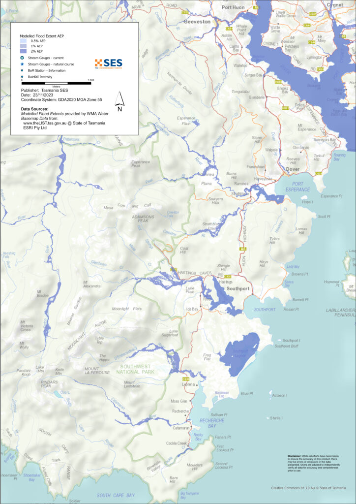
Low lying areas along the Huon River can be at risk of flooding if the Huon River has a major flood.
Parts of Dover and surrounding areas are subject to flash flooding from other waterways such as Dover Rivulet, Esperance River and Lune River if there is heavy local rain.
You are likely to experience flooding such as that shown in the maps at least once in your lifetime. Flash flooding means there is often little specific warning of flooding beyond forecasts for heavy rain or severe weather.
Even if your home is not inundated, you should be prepared for isolation plus potential power and telecommunications outages. Key access roads may be cut at Huonville, Geeveston and some other places during a major flood event. Travel in the area is likely to be difficult or impossible until roads are clear and safe. If you are safe at home or elsewhere, it is usually best you stay where you are until the flooding subsides, unless there is an emergency. If you need to evacuate, you should leave early, before flood waters rise.
Caves in the area can flood and heavy rainfall can cause cave instability. Do not enter caves in the area if heavy rain is forecast.
Listen to ABC local radio 936AM for warnings and advice.
Are you at risk of flood?
The Huon River has a long history of flooding, with major flood events in 1901, 1947, 1958, 1960, 1975, 1996, 2016 and 2022. The area often has minor flooding.
Dover and the areas south of Geeveston are exposed to weather systems from the West, South and East. The area often has heavy rain, and has had flooding before, for example in December 1995. Tasmanians need to be prepared for flood events that may not happen often, as well as the more minor flooding they may have experienced.
What should I do?
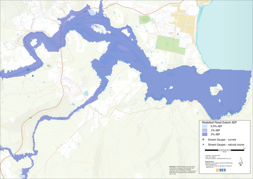
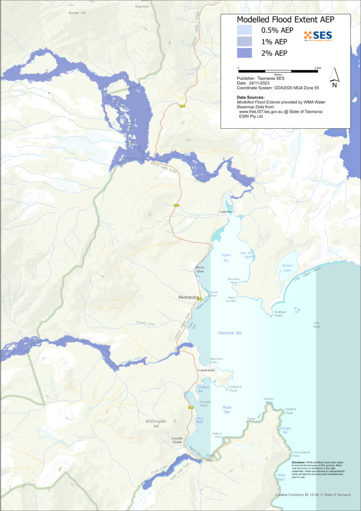
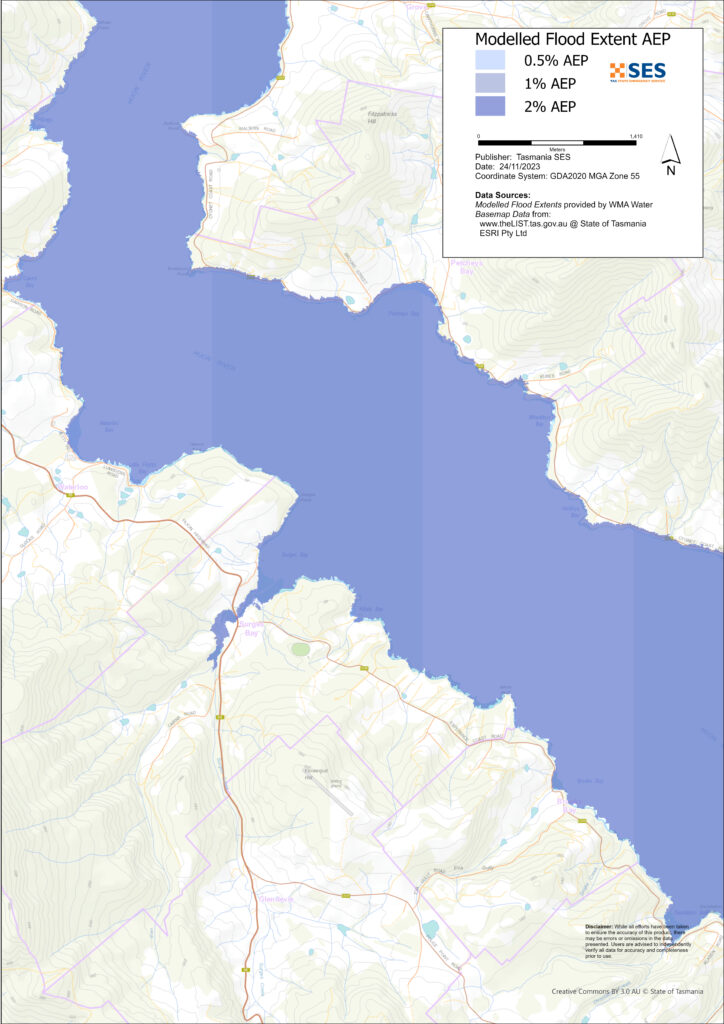
- Check the map to see whether your home or business could flood.
- Assess your home or business and prepare it to minimise possible flood damage.
- Check if you can safely get to your home, work, or school during a flood.
- Prepare a Home Emergency Plan.
- If you may be isolated and you must have access to services, you may need to evacuate early.
Avoid travel during floods.
Floods like the one shown in the map, or worse, will occur again. No two floods are the same.
If you live in a low-lying area or near a watercourse, your house may flood. Even if your home is safe, you may need to detour around flooded areas or your road access may be cut. Never drive into or enter flood waters. Roads and bridges may be washed out or unsafe.
Knowing what to do can save your life and help protect your property. Having a Home Emergency Plan is one of the best ways to prepare. Decide on weather and rainfall triggers for when to act.
Bureau of Meteorology Forecasts, Warnings, and Observations
The Bureau issues a Flood Warning, Severe Weather Warning and/or Thunderstorm Warning for heavy rainfall that may lead to flash floodingwhenever heavy rainis expected in an area. The time between the warning and heavy rain occurring can vary from an hour to 24 hours or more.
Whenever rain that may lead to flooding along the Huon River is expected, the Bureau will issue:
SES and the Bureau will issue warnings when the Huon River reaches the following levels.
| River gauges | Alert | Minor | Moderate | Major |
| Huon River at Harrison’s Opening | 5.0 | 5.0 | n/a | n/a |
| Huon River at Tahune Bridge | 4.0 | 5.0 | 6.3 | |
| Huon River at Judbury | 3.0 | 4.0 | 5.3 | 6.0 |
| Huon River at Huonville | 2.5 | 3.0 | 3.6 | 4.0 |
There are no formal warning levels for other waterways in the area as the river systems are too short.
Rainfall Observations at Dover, Southport, Hartz Mountain, Mt Bobs, Cape Bruny and/or Maatsuyker Island can indicate possible flood risks. Given the very short warning times, you are encouraged to act on the predictive BoM warnings rather than wait for any flood alerts during rainfall.
The Mt Koonya Radar is useful to be aware in real-time where heavy rainfall is falling. Radar Rainfall estimates can also fill in gaps in areas where there are no rainfall stations.
Understand the warnings and key information
Keep aware of what is happening around you. Check forecasts, observations and warnings regularly.
- TasALERT.com
- your local ABC radio station or
- the Bureau of Meteorology’s website.
 |
Advice (Yellow): an incident has started. There is no immediate danger. Stay up to date in case the situation changes. |
 |
Watch and Act (Orange): There is a heightened level of threat. Conditions are changing and you need to start taking action now to protect you and your family |
 |
Emergency Warning (Red): An Emergency Warning is the highest level of warning. You may be in danger and need to take action immediately. Any delay now puts your life at risk. |
 |
Community update (Blue): Specific information and updates for affected communities regarding a particular event or incident. |
| Incident (White): an incident is the initial occurrence of an event before it becomes an emergency warning. As soon as an incident is reported, TasALERT published basic information including the type and location of incident. |
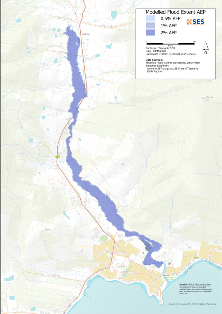
Flood levels
While no two floods are the same, the following shows what you can expect at different flood levels around the area. Even if your property is not flooded, you need to think about access. The example rainfall to cause such an event is an example: other levels of rainfall can cause flooding depending on its intensity, duration and how wet the ground is beforehand and where the rain falls.
Huon River major flooding
If there is major flooding along the Huon River, and depending on the tides, there may be flooding in low-lying areas close to the river between Geeveston and Surveyors Bay. The Huon Highway may be inundated around Surges Creek, as well as areas further north such as at Huonville, and/or Geeveston if the Kermandie River floods.
A major flood on the Huon River means the river height is at least:
- 6 metres at Judbury and
- 4 metres at Huonville Bridge.
That level of flooding is approximately the level of the 2016 floods and there is about a 10% chance of such a flood happening any year. Tasmanians need to be prepared for floods that have a 1% chance of happening every year. In this level of flooding, the river height would be about:
- 9.5 meters at Judbury and
- 5.6 meters at Huonville Bridge.
Minor or Moderate flooding along the Huon River is unlikely to cause any significant impacts in the lower areas of the river south of Geeveston, unless there is a particularly high tide.
Flooding from other waterways
Minor flooding
A minor flood can inundate low lying paddocks, orchards and other farmland. Stock should be moved for their safety. There may also be some flooding across some minor roads and parkland areas.
Moderate flooding
There is more extensive flooding of agricultural land and some buildings may be impacted to above floor height. Some properties may be isolated for a few hours as more minor roads become flooded.
Major flooding
There is at least a 2% chance in any year of major flooding along Dover Rivulet, the Esperance River, Lune River or other smaller waterways impacting Dover and surrounding communities.
This level of flooding could be as a result of about 50mm of rain over 6 hours around Dover, for example. Depending on where the rain falls, this level of flooding is likely to
- Close the Huon Highway in several places
- Flood some properties in low lying areas on the northern side of Dover around Exters Road, Ida Road and also Slaughterhouse Road
- Flood some low-lying properties around Lune River and along Esperance River Road
- Isolate popular tourist places like Hastings Caves, Lune River, Ida Bay and Cockle Creek plus wilderness areas.
Know your risk, get ready, reduce risk where you can, connect with others, stay alert and act safe.
Before a flood
1. Know your risk
Flooding often happens in Tasmania and can cause widespread and significant damage. In the past 200 years there have been 78 flood related deaths in Tasmania. This guide is to help you understand flood risk in your area.
2. Prepare your household
Have an emergency plan that covers storms and floods
Thinking about what you would do in a storm or flood means you are more prepared and everyone is safer. Have an emergency plan that everyone in your household understands. There are checklists to help you think through your plan – see the SES website or Red Cross Rediplan.
Check your plan regularly and test it by everyone in the household thinking through a flooding scenario that may affect your household.
Prepare an Emergency Kit
Ready to Go
- Battery powered radio and torch, spare batteries
- Important information, such as your emergency plan
- A list of emergency numbers
- Food and water
- First aid kit
- Rubber or strong leather gloves
Pack when needed
- Warm clothes, sturdy shoes or boots
- Medicine, glasses or other essential items
- Mobile phone and phone charger
- Pet food and anything else they need
- Photos and special keepsakes
- Money
- Important documents, for example
- insurance papers
- passports and
- birth certificates
Regularly test batteries in radios and torches.
3. Reduce your risk from flooding where you can
- Think about storms, flooding and other hazards when buying, maintaining or developing property.
- Trim or remove trees and branches overhanging your home, business or near powerlines on your property.
- Keep your gutters and drains clear.
4. Connect with others
Know your neighbours and get involved in your community. A connected community is a safer and more resilient community in an emergency and can help everyone recover better afterwards. Check that family and neighbours are safe and aware of what’s happening.
See for example the Huon Valley Good Neighbour project.
During
5. Keep up to date
Keep aware of what is happening around you. Check forecasts, observations and warnings regularly.
- TasALERT
- your local ABC radio station or
- the Bureau of Meteorology’s website.
6. Act Safe
- Supervise children.
- Prepare for possible power, water or internet outages.
- Check your emergency kit is ready to go.
- Keep clear of flooded areas such as drains. NEVER walk, play, ride or drive in floodwater. You can’t always see what is under the water or how deep or fast-moving the water is. It is easy to be swept away and drown in as little as 20cm of fast-moving water. Flood water can be dangerous.
When your home may be flooded
- Put household items up high to minimise possible damage.
- Turn off the electricity and gas if it is safe to do so.
- A great way to stop sewerage flowing back into your home is to place sandbags inside plastic bags and use them to block toilets and cover drains and sinks.
- Leave while you can get out safely.
If you need to evacuate
- Follow the advice from SES / Tasmania Police.
- Take your emergency kit.
- Go to friends or family in a safer place or an evacuation centre.
- Let others know where you have gone.
Look after your animals
You are responsible for your animals in an emergency. If you have pets and other animals it will take you longer to evacuate in a flood or other emergency. Move livestock from flood prone areas well before flood waters may rise. For more information see
- RSPCA’s guidance on preparing for animals in an emergency
- Huon Valley Council’s advice on preparing an emergency pet plan
- the Primary producer farm flood readiness toolkit.
Avoid travelling during and after storms
- Do not go sightseeing. Sightseers delay emergency services and cause accidents.
- Watch out for hazards such as
- water over roads
- damaged powerlines
- landslides
- damaged roads
- falling trees or roofing iron.
- Never drive through flood waters. Most deaths and rescues in floods are from people driving through flood waters.
- Drive slowly and turn your headlights on roads not affected by flood waters.
After
- Keep listening for ABC Local Radio updates, road re-openings, community meetings, etc.
- If you left your home, do not return home until SES or Tasmania Police tell you it is safe to do so.
- Be aware of road hazards, such as mud or debris on the road, damaged roads/bridges and crews working on clean-up and repairs.
If your home has been damaged
- Stay at ground level while checking for damage. Be careful of fallen trees, broken glass, loose roofing or other hazards.
- Wear strong boots, gloves and protective clothes.
- Use a torch, never use matches or candles inside flood affected buildings.
- Boil all drinking water until you are told the tap water is safe again.
- Do not turn on it is tested by a licensed electrician or gas fitter for safety.
- If your home is damaged and you need to stay somewhere else, take your emergency kit and pets with you
- Take photos of any damage if safe for you to do so and contact your insurance company.
- Supervise children.
- Check neighbours are okay.
For further information go to www.ses.tas.gov.au
Staying informed and further information
Current warnings (TasAlerts) alerts.tas.gov.au
Bureau of Meteorology (BoM)
Emergency Broadcasters ABC 936AM
TASSES Social Media
- facebook.com/sestasmania
- twitter.com/sestasmania
Preparing for Flood Emergencies ses.tas.gov.au/plan-prepare/flood
Huon Valley Council huonvalley.tas.gov.au 6264 0300
National Relay Service (NRS) relayservice.gov.au