Riverine and flash flooding flooding information for communities on the Derwent River and its tributaries around Bushy Park, Glenora, Plenty, Gretna and Hayes.
DRAFT – Please email any comments to ses@ses.tas.gov.au
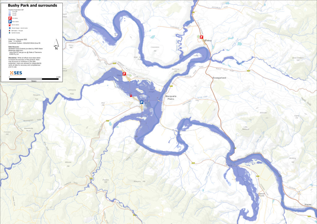
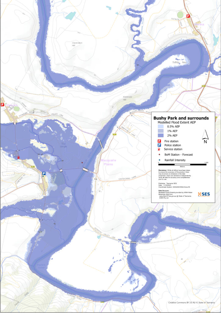
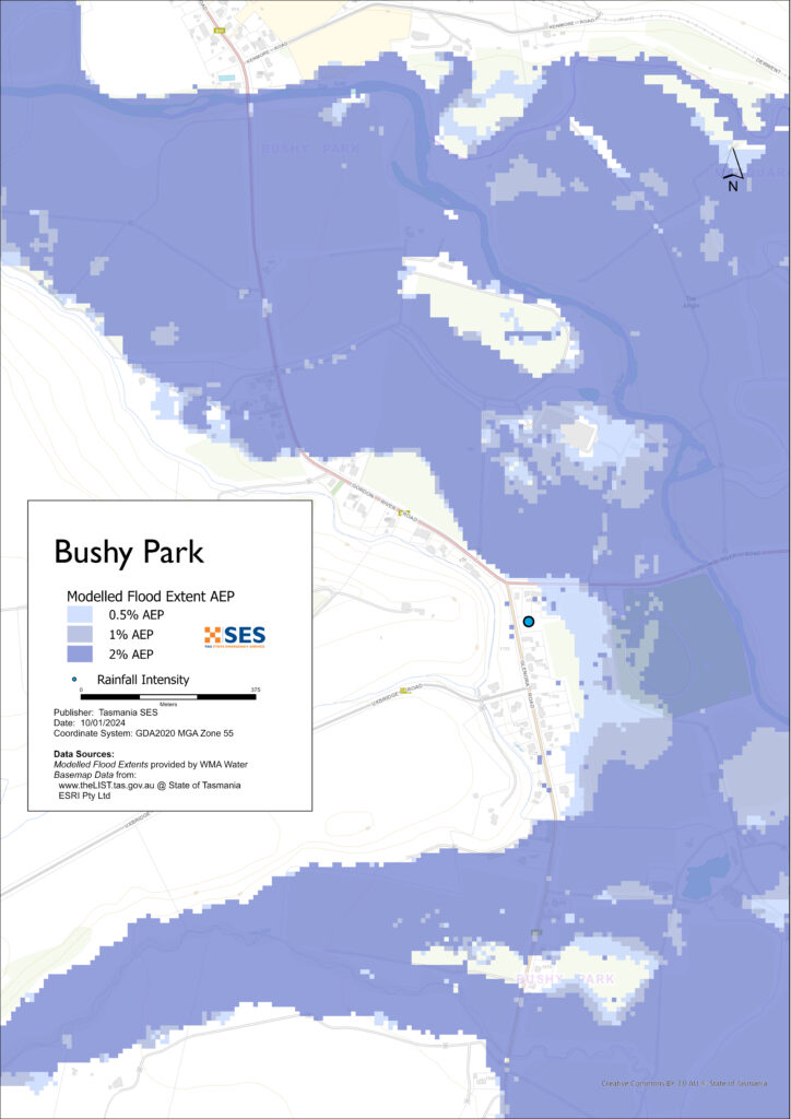
Parts of Bushy Park, Macquarie Plains, Glenora, Plenty, Gretna, Hayes and surrounding areas are subject to flooding from the Derwent and/or its tributaries, such as the Styx River and the Plenty River. The Derwent River and its tributaries may flood at the same time or at different times. Low lying areas may also be impacted by storm water runoff following local high rainfall events.
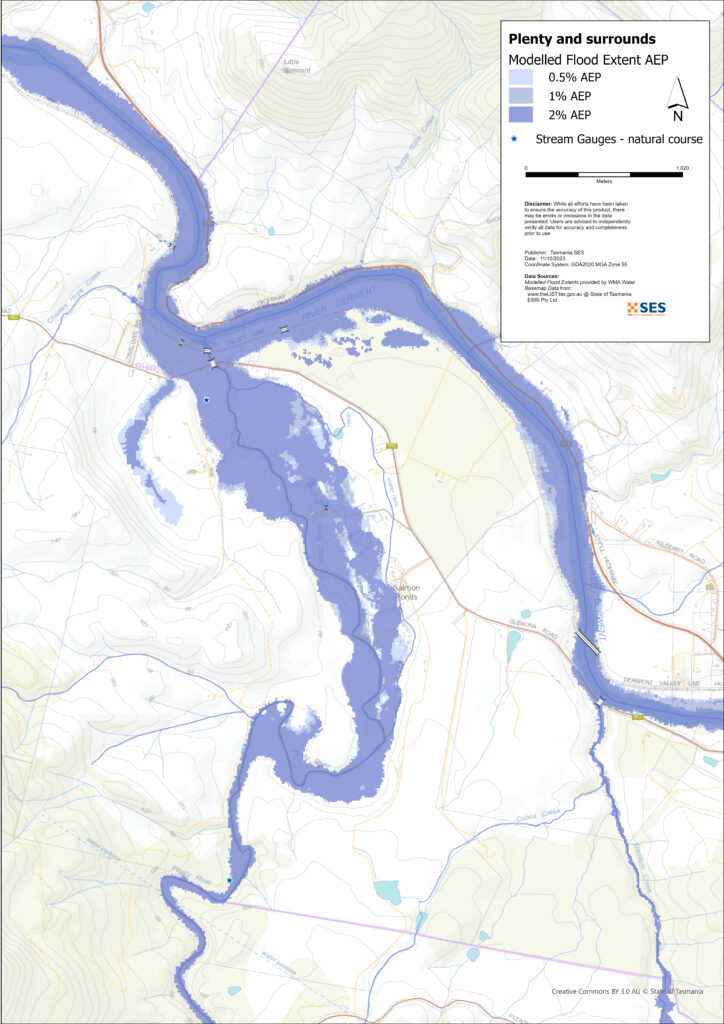
The maps show the estimated flood levels for widespread rain that has a 2%, 1% and 0.5% chance of happening any year (2%, 1% and 0.5% Annual Exceedance Probability (AEP)). You are likely to experience this level of flooding at least once in your lifetime.
Widespread heavy rainfall in the Derwent catchment can cause widespread flooding particularly around Bushy Park and Glenora’s agricultural areas and nearby homes and other property.
Melting snow, rain on snow, the level of soil moisture and the dam levels can impact flood levels. However, dam level management is not likely to have any significant impact during a major flood event.
Styx River flooding can impact agricultural land around Glenora and Bushy Park.
Flooding in the Plenty River can flood areas around Salmon Ponds, and properties near where the Plenty River joins the Derwent, particularly if the Derwent River is in flood.
Are you at risk of flood?
The area has a long history of flooding. The most significant flood since European settlement in 1960 flooded large areas of farmland, many homes and other buildings and isolated the area. Flooding also happened in 1916, 1922, 1923, 1924, 1946, 1947, 1948, 1951, 1952, 1953, 1958, 1962, 1970, 1971, 1974, 1975, 1980, 1988, 1991, 1994, 2007, 2009, 2011, 2016 and 2018.
It is important to be prepared for flooding events that may not have happened within most people’s living memory.
What should I do?
- Check the map opposite to see whether your home or business is likely to be at risk of flooding during a flood.
- Prepare a Home Emergency Plan, including whether you need to evacuate in advance of a flood, where you will go and what you need to take.
- If you have a business in the area, you should have a plan that covers flooding. Business Tasmania can help– see www.business.tas.gov.au/manage_a_business/
- If you need to evacuate or return home during a flood, make sure your route is safe.
- Asses your home or business and know what you need to do to prepare it to minimise possible damage from water inundation.
Floods like the one shown on the map, or worse, will occur again. No two floods are the same.
If you live in a low-lying area or near a watercourse, your house may flood. Even if your home is safe, you may need to detour around flooded areas or your road access may be cut. Never drive into or enter flood waters. Roads and bridges may be washed out or unsafe. Avoid travel during floods.
Knowing what to do can save your life and help protect your property. Having a Home Emergency Plan is one of the best ways to prepare. Decide on weather and rainfall triggers for when to act.
Bureau of Meteorology Forecasts, Warnings, and Observations
The Bureau of Meteorology monitors rainfall and river levels in the upper reaches of the Derwent River. They issue flood warnings when river levels are likely to reach the following heights. SES works closely with the Bureau to provide timely warnings where possible.
| River gauges | Alert | Minor | Moderate | Major |
| Ouse River at Ashton | 2.4m | 2.4m | 3.2 | 4.5 |
| Ouse River at 3B Weir | 3.0 | 3.7 | 4.3 | |
| Clyde River at Bothwell | 0.9m | 2.0m | 3.0 | 4.0 |
| Styx River at Bruces Bridge | 2.0m | n/a | n/a | |
| Derwent River below Meadowbank Dam | 4.1m | 4.1m | 6.1m | 7.3m |
| Derwent River at Macquarie Plains | 4.0m | 4.0m | 5.0m | 6.7m |
| Plenty River at Feilton | 2.8m | n/a | n/a | |
| Derwent River at New Norfolk | 2.0m (2.3m estimated 50% AEP) | 4.0m (4.31m estimated 10%AEP) | 6.0 (6.3m estimated 1% AEP) |
Notes
- % AEP (Annual Exceedance Probability) is estimated and only a rough guide. Rainfall levels and so flood levels can differ greatly across the catchment in a flooding event. More precise estimates of gauge and flood warning levels is a work in progress.
- A major level in the upper catchment may not translate to a major level at New Norfolk if there is not high rainfall in other parts of the catchment.
- While previously the 1960 flood was considered about a 0.75%AEP event (1 in 150 year event), more recent information suggests the event was more rare, that is, with less than a 0.5% chance of happening any year.
For information on flood warnings in the Lachlan River see the related Lachlan River Flood Guide. In summary, there are no water level gauges on this river – the short catchment does not give enough time to issue a warning before flooding arrives. Keep an eye on rainfall on kunanyi/ the Wellington Range.
Whenever heavy rain is expected in an area that may lead to flooding, the Bureau issues
- Severe Weather Warning and/or
- Thunderstorm Warning for heavy rainfall that may lead to flash flooding.
Download BOM Weather app and set your location to receive push notifications of warnings (more details at www.bom.gov.au/app/) .
Listen to ABC 936AM or go to tasalert.com for warnings.
Understand the warnings and key information
Keep aware of what is happening around you. Check forecasts, observations and warnings regularly.
- TasALERT.com
- your local ABC radio station or
- the Bureau of Meteorology’s website.
 |
Advice (Yellow): an incident has started. There is no immediate danger. Stay up to date in case the situation changes. |
 |
Watch and Act (Orange): There is a heightened level of threat. Conditions are changing and you need to start taking action now to protect you and your family |
 |
Emergency Warning (Red): An Emergency Warning is the highest level of warning. You may be in danger and need to take action immediately. Any delay now puts your life at risk. |
 |
Community update (Blue): Specific information and updates for affected communities regarding a particular event or incident. |
| Incident (White): an incident is the initial occurrence of an event before it becomes an emergency warning. As soon as an incident is reported, TasALERT published basic information including the type and location of incident. |
Flood levels around the Derwent River
While no two floods are the same, the following describes what is likely to happen if there is flooding around the area. Even if your property is not flooded, you need to think about access.
The rainfall amounts that might cause such an event are examples. Other levels of rainfall can cause flooding depending on
- where the rain falls
- how heavy the rain is
- how long the rain lasts, and
- how wet the ground is beforehand.
Melting snow can also contribute to flooding.
Minor flooding
Derwent River levels at Macquarie Plains are at least 4m and/or Styx River at Bruces Bridge at least 2m and/or the Plenty River at Feilton is at least 2.8m
- Water spills over riverbanks and covers nearby low-lying areas.
- Agricultural and horticultural land on river flats may be at risk. Livestock should be moved from these areas.
Moderate flooding
River levels at Macquarie Plains are at least 5m
- There is more extended and deeper flooding of agricultural land along river flats with some stock losses if not moved. There may be damage to fences and equipment such as pumps.
- Some low lying areas of the Lyell Highway and Glenora Road may begin to flood
- Flooding may reach above floor heights of some low-lying houses and other buildings.
- Some properties above low-lying bridges may become isolated.
Major flooding
Derwent River levels at Macquarie Plains are at least 6.7m
Widespread heavy rainfall across the catchment that has a 1- 2% chance or less of happening can cause major flooding. This level of rainfall might be for example more than:
- 53mm over 6 hours
- 73mm over 12 hours
- 101 mm over 24 hours
- 132mm over 48 hours
Note the level of flooding can depend on many factors, such as where the rain falls and how widespread it is, and how wet the catchment is beforehand. Areas that are likely to be flooded from Derwent River flooding include on the Southwest side of the river:.
- The Bushy Park Roadhouse and surrounds
- Bushy Park to the north of Gordon River Rd
- Salmon Ponds and surrounds
- Parts of the Plenty Valley Road at Fielton and some low-lying sheds
- Glenora Road near Raynor’s Corner and nearby low lying properties
The Styx River can also cause flooding in agricultural land around Glenora and Bushy Park.
Areas at risk of inundation on the Northeast side of the river include:
- Marked Hill Road, Clarendon Road, Askrigg Road and the Lyell Highway near Gretna
- Several areas of the Lyell Highway at Hayes, plus nearby surrounding properties.
The area is likely to become isolated from New Norfolk and upstream areas due to flooding across the Lyell Highway and Glenora Road. Other potential areas of isolation are:
- SE New Norfolk/ Brookside
- New Norfolk CBD south side Derwent
- New Norfolk north side river, Lawitta, Magra
- Pulpit Rock Road
- Glenora Road West of New Norfolk
- Glenfern Road and surrounds
If flooding levels reach the same heights as the 1960 floods in New Norfolk (6.8m), flooding in the areas already listed will be deeper, and could spread to the following areas:
- Glenora
- Bushy Park/ Uxbridge Rd
- Glenora Rd various areas
- Plenty
- Rosegarland
- Hayes
Go to tasalert.tas.gov.au or listen to ABC local radio for detailed up to date information and advice during heavy rainfall events.
Know your risk, get ready, reduce risk where you can, connect with others, stay alert and act safe.
Before a flood
1. Know your risk
Flooding often happens in Tasmania and can cause widespread and significant damage. In the past 200 years there have been 78 flood related deaths in Tasmania. This guide is to help you understand flood risk in your area.
2. Prepare your household
Have an emergency plan that covers storms and floods
Thinking about what you would do in a storm or flood means you are more prepared and everyone is safer. Have an emergency plan that everyone in your household understands. There are checklists to help you think through your plan – see the SES website or Red Cross Rediplan.
Check your plan regularly and test it by everyone in the household thinking through a flooding scenario that may affect your household.
Prepare an Emergency Kit
Ready to Go
- Battery powered radio and torch, spare batteries
- Important information, such as your emergency plan
- A list of emergency numbers
- Food and water
- First aid kit
- Rubber or strong leather gloves
Pack when needed
- Warm clothes, sturdy shoes or boots
- Medicine, glasses or other essential items
- Mobile phone and phone charger
- Pet food and anything else they need
- Photos and special keepsakes
- Money
- Important documents, for example
- insurance papers
- passports and
- birth certificates
Regularly test batteries in radios and torches.
3. Reduce your risk from flooding where you can
- Think about storms, flooding and other hazards when buying, maintaining or developing property.
- Trim or remove trees and branches overhanging your home, business or near powerlines on your property.
- Keep your gutters and drains clear.
4. Connect with others
Know your neighbours and get involved in your community. A connected community is a safer and more resilient community in an emergency and can help everyone recover better afterwards. Check that family and neighbours are safe and aware of what’s happening.
See for example the Huon Valley Good Neighbour project.
During
5. Keep up to date
Keep aware of what is happening around you. Check forecasts, observations and warnings regularly.
- TasALERT
- your local ABC radio station or
- the Bureau of Meteorology’s website.
6. Act Safe
- Supervise children.
- Prepare for possible power, water or internet outages.
- Check your emergency kit is ready to go.
- Keep clear of flooded areas such as drains. NEVER walk, play, ride or drive in floodwater. You can’t always see what is under the water or how deep or fast-moving the water is. It is easy to be swept away and drown in as little as 20cm of fast-moving water. Flood water can be dangerous.
When your home may be flooded
- Put household items up high to minimise possible damage.
- Turn off the electricity and gas if it is safe to do so.
- A great way to stop sewerage flowing back into your home is to place sandbags inside plastic bags and use them to block toilets and cover drains and sinks.
- Leave while you can get out safely.
If you need to evacuate
- Follow the advice from SES / Tasmania Police.
- Take your emergency kit.
- Go to friends or family in a safer place or an evacuation centre.
- Let others know where you have gone.
Look after your animals
You are responsible for your animals in an emergency. If you have pets and other animals it will take you longer to evacuate in a flood or other emergency. Move livestock from flood prone areas well before flood waters may rise. For more information see
- RSPCA’s guidance on preparing for animals in an emergency
- Huon Valley Council’s advice on preparing an emergency pet plan
- the Primary producer farm flood readiness toolkit.
Avoid travelling during storms and after storms
- Do not go sightseeing. Sightseers delay emergency services and cause accidents.
- Watch out for hazards such as
- water over roads
- damaged powerlines
- landslides
- damaged roads
- falling trees or roofing iron.
- Never drive through flood waters. Most deaths and rescues in floods are from people driving through flood waters.
- Drive slowly and turn your headlights on roads not affected by flood waters.
After
- Keep listening for ABC Local Radio updates, road re-openings, community meetings, etc.
- If you left your home, do not return home until SES or Tasmania Police tell you it is safe to do so.
- Be aware of road hazards, such as mud or debris on the road, damaged roads/bridges and crews working on clean-up and repairs.
If your home has been damaged
- Stay at ground level while checking for damage. Be careful of fallen trees, broken glass, loose roofing or other hazards.
- Wear strong boots, gloves and protective clothes.
- Use a torch, never use matches or candles inside flood affected buildings.
- Boil all drinking water until you are told the tap water is safe again.
- Do not turn on it is tested by a licensed electrician or gas fitter for safety.
- If your home is damaged and you need to stay somewhere else, take your emergency kit and pets with you
- Take photos of any damage if safe for you to do so and contact your insurance company.
- Supervise children.
- Check neighbours are okay.
For further information go to www.ses.tas.gov.au
Staying informed and further information
Current warnings (TasAlerts) alerts.tas.gov.au
Bureau of Meteorology (BoM)
Emergency Broadcasters ABC 936AM
TASSES Social Media
- facebook.com/sestasmania
- twitter.com/sestasmania
Preparing for Flood Emergencies ses.tas.gov.au/plan-prepare/flood
Derwent Valley Council derwentvalley.tas.gov.au 6261 8500
National Relay Service (NRS) relayservice.gov.au