Railton Flood Guide
Riverine flooding information for Redwater Creek
Railton is subject to flooding from:
- Redwater Creek
- Overland Flow
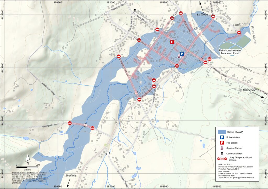
The map shows the expected 1% Annual Exceedance Probability Flood level in Railton. Railton is likely to experience a flood of this size at least once every 100 years.
Flooding of Redwater Creek is not measured by a flood gauge, so you will not receive warnings from the Bureau of Meteorology or the State Emergency Service that give you specific flood heights.
Flooding can occur in Railton soon after rain falls, with little or no warning. Redwater Creek breaks its banks when flooding Railton. Floodwaters find many overland flow paths. Flooding quickly affects many lower lying areas in Railton near to and away from the Creek.
Are you at risk of flood?
Railton has a history of significant flooding, including in 1876, 1894, 1929, 1970, 1973, 2011 and 2016. The flood in 2011 was approximately equal to, or just exceeded, the 1% Annual Exceedance Probability (AEP) level. This flood affected 60 houses, 14 businesses plus roads and streets throughout the town. Check the map to see whether your home or business could flood.
In past floods people from Railton have been trapped by flood waters in their cars and house roofs. Flooding of Redwater Creek in Railton often occurs at the same time as flooding of other water courses in the area, including the Mersey River and the Dasher River. This means that the roads between Railton and other towns such as Sheffield and Latrobe can be flooded and damaged. Emergency Services from other towns may not be able to access Railton in the event of a flood. You should be prepared to respond to, and recover from, a flood with the help from other members of the Railton community.
Bureau of Meteorology Forecasts, Warnings, and Observations
A Flood Watch or Flood Warnings is issued when predicted weather might cause floods in one or two days. A Flood Watch may
- be for a specific area such as Railton, or
- be generalised such as for Northern river basins or the Central North forecast district.
Flood Warnings are expressed as Minor, Moderate, or Major.
Severe Weather Warning for very heavy rain that may lead to flash flooding are issued whenever this weather is occurring or is expected to move into an area. The amount of time between the warning and the arrival of the heavy rain can vary from just an hour to 24 hours or sometimes more.
Rainfall Observations for Sheffield and Kimberley can provide an indication of the rainfall in the catchments around Railton. Tasmania weather can be unpredictable. You will need to make decisions based on local conditions. You may not receive any warnings.
Flood levels at Railton
Severe Weather Warnings and Flood Watches issued by the Bureau of Meteorology can include a forecast of the amount of rain likely to be experienced in an area. See detailed rain forecasts for Railton on the MetEye page on the BoM website.
While no two floods are the same, 24 hour rainfall totals at Railton can help you estimate how much flooding could occur. Flooding can also occur if a large amount of rain falls quickly in a short time, or it rains for days in a row.
While no two floods are the same, the following table shows what you can expect at different flood levels around Geeveston. Even if your property is not flooded, you need to think about access routes.
Note there are planned mitigation works to reduce flood risk around Railton. See the Kentish Council website for more information.
A 1:10 year/10%AEP event
- For example, be a result of about 54 mm rain in 6 hours
- May inundate parts of Latrobe Road, the Esplanade, Crockers St, Morrison St, Giblin Street Dowbiggen Road and surrounding properties plus the railway line in some places.
- Unflooded parts of Kimberley Road may be isolated as the road is flooded near Kimberley.
- The school is unlikely to be flooded but students may not be able to travel north or east.
- Water may come up through drains in streets and cover some minor roads paths, tracks and low-level bridges on back roads.
A 1:50 year / 5%AEP event
- For example, be a result of about 76 mm of rain in 6 hours.
- Extend flooding around the township, for example, Latrobe Street to near the intersection with King Street, plus surrounding properties.
- Create flood island around the township, isolated households. Inundate shops in the centre of the township.
- Flooding in surrounding areas may also impact transport.
A 1:100 year /1%AEP event
- For example, be a result of about 86 mm of rain in 6 hours.
- Be similar to the flooding in 2011.
- Extend flooding, for example, around the intersection of Leake Street, Foster Street and surrounding properties, Kimberley St near the intersection with Latrobe Road.
- Isolate some unflooded parts of Foster Street and some back roads, such as the intersection of Leake Street and Foster Street and New Bed Road west of the school.
- Inundate the sewerage works off King St.
Know your risk, get ready, reduce risk where you can, connect with others, stay alert and act safe.
Before a flood
1. Know your risk
Flooding often happens in Tasmania and can cause widespread and significant damage. In the past 200 years there have been 78 flood related deaths in Tasmania. This guide is to help you understand flood risk in your area. Familiarise yourself with evacuation routes or higher places that will be safer from flooding, noting a flood event in Railton is unlikely to last more than 12 hours.
2. Prepare your household
Have an emergency plan that covers storms and floods
Thinking about what you would do in a storm or flood means you are more prepared and everyone is safer. Have an emergency plan that everyone in your household understands. There are checklists to help you think through your plan – see the SES website or Red Cross Rediplan.
Check your plan regularly and test it by everyone in the household thinking through a flooding scenario that may affect your household.
Prepare and emergency kit
Ready to Go
Battery powered radio and torch, spare batteries
Important information, such as your emergency plan
A list of emergency numbers
Food and water
First aid kit
Rubber or strong leather gloves
Pack when needed
Warm clothes, sturdy shoes or boots
Medicine, glasses or other essential items
Mobile phone and phone charger
Pet food and anything else they need
Photos and special keepsakes
Important documents, for example
– insurance papers
– passports and
– birth certificates
Regularly test batteries in radios and torches.
3. Reduce your risk from flooding where you can
- Think about storms, flooding and other hazards when buying, maintaining or developing property.
- Trim or remove trees and branches overhanging your home, business or near powerlines on your property.
- Keep your gutters and drains clear.
4. Connect with others
Know your neighbours and get involved in your community. A connected community is a safer and more resilient community in an emergency and can help everyone recover better afterwards. Check that family and neighbours are safe and aware of what’s happening.
During
5. Keep up to date
Keep aware of what is happening around you. Check forecasts, observations and warnings regularly.
- TasALERT
- your local ABC radio station or
- the Bureau of Meteorology’s website.
Understand the warnings and key information
 | Advice (Yellow): an incident has started. There is no immediate danger. Stay up to date in case the situation changes. |
 | Watch and Act (Orange): There is a heightened level of threat. Conditions are changing and you need to start taking action now to protect you and your family |
 | Emergency Warning (Red): An Emergency Warning is the highest level of warning. You may be in danger and need to take action immediately. Any delay now puts your life at risk. |
 | Community update (Blue): Specific information and updates for affected communities regarding a particular event or incident. |
| Incident (White): an incident is the initial occurrence of an event before it becomes an emergency warning. As soon as an incident is reported, TasALERT published basic information including the type and location of incident. |
6. Act Safe
- Supervise children.
- Prepare for possible power, water or internet outages.
- Check your emergency kit is ready to go.
- Keep clear of flooded areas such as drains. NEVER walk, play, ride or drive in floodwater. You can’t always see what is under the water or how deep or fast-moving the water is. It is easy to be swept away and drown in as little as 20cm of fast-moving water. Flood water can be dangerous.
When your home may be flooded
- Put household items up high to minimise possible damage.
- Turn off the electricity and gas if it is safe to do so.
- A great way to stop sewerage flowing back into your home is to place sandbags inside plastic bags and use them to block toilets and cover drains and sinks.
- Leave while you can get out safely.
If you need to evacuate
- Follow the advice from SES / Tasmania Police.
- Take your emergency kit.
- Go to friends or family in a safer place or an evacuation centre.
- Let others know where you have gone.
Look after your animals
You are responsible for your animals in an emergency. If you have pets and other animals it will take you longer to evacuate in a flood or other emergency. Move livestock from flood prone areas well before flood waters may rise. For more information see
- RSPCA’s guidance on preparing for animals in an emergency
- Huon Valley Council’s advice on preparing an emergency pet plan
- the Primary producer farm flood readiness toolkit
Avoid travelling during and after storms
- Do not go sightseeing. Sightseers delay emergency services and cause accidents.
- Watch out for hazards such as
- water over roads
- damaged powerlines
- landslides
- damaged roads
- falling trees or roofing iron.
- Never drive through flood waters. Most deaths and rescues in floods are from people driving through flood waters.
- Drive slowly and turn your headlights on roads not affected by flood waters.
After
- Keep listening for ABC Local Radio updates, road re-openings, community meetings, etc.
- If you left your home, do not return home until SES or Tasmania Police tell you it is safe to do so.
- Be aware of road hazards, such as mud or debris on the road, damaged roads/bridges and crews working on clean-up and repairs.
If your home has been damaged
- Stay at ground level while checking for damage. Be careful of fallen trees, broken glass, loose roofing or other hazards.
- Wear strong boots, gloves and protective clothes.
- Use a torch, never use matches or candles inside flood affected buildings.
- Boil all drinking water until you are told the tap water is safe again.
- Do not turn on it is tested by a licensed electrician or gas fitter for safety.
- If your home is damaged and you need to stay somewhere else, take your emergency kit and pets with you
- Take photos of any damage if safe for you to do so and contact your insurance company.
- Supervise children.
- Check neighbours are okay.
For further information go to www.ses.tas.gov.au
Staying informed and further information
Bureau of Meteorology (BoM) bom.gov.au/tas/warnings
Emergency Broadcasters ABC East Devonport 100.5FM or listen online.
TASSES Social Media
Preparing for Flood Emergencies
National Relay Service (NRS)
Developed in partnership with Kentish Council.