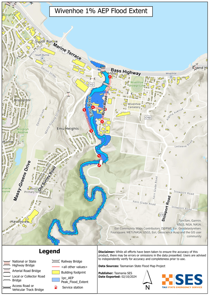
Riverine flooding information for areas surrounding Emu River
DRAFT version 0.5 APRIL 2025 – email comments to ses@ses.tas.gov.au
To see the maps in more detail, see the Tasmanian Strategic Flood Maps.
Emu River
If there is heavy sustained rain, Emu River may flood its surrounds in Wivenhoe, particularly when tides are high.
- Businesses located south of the TasRail line are most likely to be inundated.
- Fern Glade parklands may flood.
- River Road may become impassable and isolate some businesses until river levels drop.
- Debris may build up around water crossings, including the rail bridge and fuel/gas pipeline. If this happens, these water crossings may be closed for safety reasons.
Flash flooding can affect across Wivenhoe and along the Emu River. Flash flooding means there can be little specific warning beyond forecasts for heavy rain or severe weather.
The maps in this guide show the level of flooding that has a 1% chance of happening any year (1% Annual Exceedance Probability (AEP)). You are likely to experience flooding such as that shown in the maps in your lifetime. Tasmanians need to prepare for flood events that may not happen often as well as the minor flooding they may have experienced.
Even if your business or home is not inundated, you should be prepared for isolation plus potential power and telecommunications outages.
Travel in the area is likely to be difficult or impossible until roads are clear. If you are safe at home, your work or elsewhere, it is usually best you stay where you are until the flooding subsides, unless there is an emergency. If you need to evacuate, you should leave early, before flood waters rise.
If the Wivenhoe area is at risk of flooding, there is likely to also be flooding in surrounding areas. This may impact your employees, and their ability to work for you during the flooding event.
If you own or manage a business, you should have an emergency plan that covers floods. This can help you to reduce your losses from flooding and other emergencies. It can also help you to continue operating during and after a major flood. Business Tasmania has resources and support to help – see: www.business.tas.gov.au/managing/risk_management.
Go to TasALERT.com or listen to ABC local radio 102.5 FM for warnings and advice.
Are you at risk of flood?
Past flooding events around Wivenhoe include:
- 1929 – Bass Highway & Fern Glade Road bridges were washed away. There was significant debris at Railway Bridge.
- 2011 – Fern Glade Road bridge was severely damaged. Low-lying properties in River Road were flooded. There was again a lot of debris at Railway Bridge
- 2016 – Widespread inundation of River Road industrial area, caused significant economic loss. Debris such as trees and branches at railway bridge impacted nearby assets.
- 2022 – Significant inundation of low-lying properties in River Road. There was again woody debris pushed against Railway Bridge.
As an example, the 2016 widespread flooding of the River Road industrial area caused
- significant economic loss to local businesses, and
- the wider effects of disruption to business activity.
What should I do?
- Check the map to see whether your business could flood.
- Assess your business premises and prepare it to minimise possible flood damage.
- Determine if your employees can safely access the workplace during a flood event.
- Prepare a Business Emergency Plan and Business Continuity Plan to ensure operational resilience.
- If your business relies on supply chains or customer access, consider early closure and evacuation, with alternative solutions to minimise disruptions.
Floods like the one shown in the maps, or worse, will occur again. No two floods are the same. If your business is in a low-lying area or near a watercourse, it may be at risk of flooding. Even if your premises are not directly impacted, road closures and infrastructure damage may impact your operations. Never drive into or enter flood waters. Roads and bridges may be washed out or unsafe. Avoid travel during floods.
Understanding your flood risk and preparing in advance can help protect your business assets and employees. Having a Business Emergency Plan is one of the best ways to prepare. Decide on weather and rainfall triggers for when to act.
Burnie City Council has install local river and rainfall gauging for the Emu River. Access via the Orion Portal. Use the following login credentials to access the portal:
- Username: EmuRiver
- Password: EmuRiver7320!
Bureau of Meteorology Forecasts, Warnings, and Observations
The Emu River catchment has no formal flood warnings or flood classification levels. The river catchment is too short to give timely warnings based on river rises.
Whenever heavy rain is expected in an area that may lead to flooding, the Bureau issues
- Severe Weather Warning, and/or
- Thunderstorm Warning for heavy rainfall that may lead to flash flooding.
The time between the warning and heavy rain falling can vary from an hour to 24 hours or more.
Rainfall Observations at Burnie (Park Grove) and Yolla and other nearby rain gauges can indicate possible flood risks. Given the very short warning times, it is best to act on the BoM warnings rather than wait for specific flood alerts during rainfall.
The N.W. Tasmania (West Takone) radar is useful to be aware in real-time where heavy rainfall is falling. Radar Rainfall estimates can also fill in gaps in areas where there are no rainfall stations.
Understand the warnings and key information
Keep aware of what is happening around you. Check forecasts, observations and warnings regularly.
- TasALERT.com
- your local ABC radio station or
- the Bureau of Meteorology’s website.
 |
Advice (Yellow): an incident has started. There is no immediate danger. Stay up to date in case the situation changes. |
 |
Watch and Act (Orange): There is a heightened level of threat. Conditions are changing and you need to start taking action now to protect you and your family |
 |
Emergency Warning (Red): An Emergency Warning is the highest level of warning. You may be in danger and need to take action immediately. Any delay now puts your life at risk. |
 |
Community update (Blue): Specific information and updates for affected communities regarding a particular event or incident. |
 |
Incident (White): an incident is the initial occurrence of an event before it becomes an emergency warning. As soon as an incident is reported, TasALERT publishes basic information including the type and location of incident. |
For more information see www.ses.tas.gov.au/warnings/ .
Flood levels
While no two floods are the same, the following describes what is likely to happen if there is flooding around the area. Even if your property is not flooded, you need to think about access.
The rainfall amounts that might cause such an event are examples. Other levels of rainfall can cause flooding depending on
- where the rain falls
- how heavy the rain is
- how long the rain lasts, and
- how wet the ground is beforehand.
- Melting snow can also contribute to flooding.
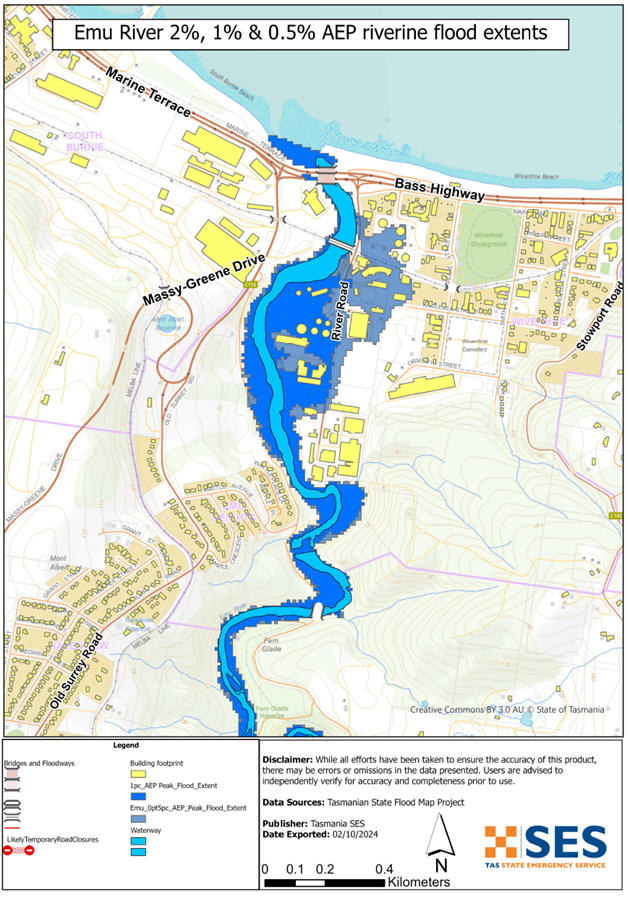
Minor flooding (5%-10% chance annually)
- Some low-lying businesses and parkland along River Road may experience flooding.
- Parts of River Road may have minor water accumulation but remain passable.
- Heavy rain may lead to localised stormwater runoff affecting business premises.
Moderate Flooding (2%-5% chance annually)
- River Road may become impassable.
- More low-lying businesses along River Road may experience significant flooding.
Major Flooding (1% chance annually – comparable to 2022 floods):
- River Road will be inundated, isolating surrounding commercial properties.
- Businesses in reclaimed or low-lying areas may experience above-floor flooding.
- Flooding may extend to Fern Glade Reserve and Fern Glade Road.
Emu River flooding
Depending on where the rain falls and the tide level, major flooding is likely to inundate
- River Road roadway, isolating surrounding properties
- Commercial properties above floor level, particularly those in the low-lying and reclaimed areas along River Road
- Fern Glade Reserve and Fern Glade Road
Flooding from other waterways
If there is heavy local rainfall, there can be flash flooding around.
- Old Park River and Pet River (Emu River tributaries)
- Other low lying areas of Wivenhoe
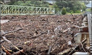
Image: Debris accumulation at Railway Bridge in the October 2022 flood event (SES)
Know your risk, get ready, reduce risk where you can, connect with others, stay alert and act safe.
Before a flood
1. Know your risk
Flooding often happens in Tasmania and can cause widespread and significant damage. In the past 200 years there have been 78 flood related deaths in Tasmania. This guide is to help you understand flood risk in your area.
2. Prepare your household
Have an emergency plan that covers storms and floods
Thinking about what you would do in a storm or flood means you are more prepared and everyone is safer. Have an emergency plan that everyone in your household understands. There are checklists to help you think through your plan – see Get Ready for Emergencies – A guide for individuals and households to prepare for emergencies.
Check your plan regularly and test it by everyone in the household thinking through a flooding scenario that may affect your household.
Prepare an Emergency Kit
Ready to Go
- Battery powered radio and torch, spare batteries
- Important information, such as your emergency plan
- A list of emergency numbers
- Food and water
- First aid kit
- Rubber or strong leather gloves
Pack when needed
- Warm clothes, sturdy shoes or boots
- Medicine, glasses or other essential items
- Mobile phone and phone charger
- Pet food and anything else they need
- Photos and special keepsakes
- Money
- Important documents, for example
- insurance papers
- passports and
- birth certificates
Regularly test batteries in radios and torches.
3. Reduce your risk from flooding where you can
- Think about storms, flooding and other hazards when buying, maintaining or developing property.
- Trim or remove trees and branches overhanging your home, business or near powerlines on your property.
- Keep your gutters and drains clear.
4. Connect with others
Know your neighbours and get involved in your community. A connected community is a safer and more resilient community in an emergency and can help everyone recover better afterwards. Check that family and neighbours are safe and aware of what’s happening.
During
5. Keep up to date
Keep aware of what is happening around you. Check forecasts, observations and warnings regularly.
- TasALERT
- your local ABC radio station or
- the Bureau of Meteorology’s website.
6. Act Safe
- Supervise children.
- Prepare for possible power, water or internet outages.
- Check your emergency kit is ready to go.
- Keep clear of flooded areas such as drains. NEVER walk, play, ride or drive in floodwater. You can’t always see what is under the water or how deep or fast-moving the water is. It is easy to be swept away and drown in as little as 20cm of fast-moving water. Flood water can be dangerous.
When your home may be flooded
- Put household items up high to minimise possible damage.
- Turn off the electricity and gas if it is safe to do so.
- A great way to stop sewerage flowing back into your home is to place sandbags inside plastic bags and use them to block toilets and cover drains and sinks.
- Leave while you can get out safely.
If you need to evacuate
- Follow the advice from SES / Tasmania Police.
- Take your emergency kit.
- Go to friends or family in a safer place or an evacuation centre.
- Let others know where you have gone.
Look after your animals
You are responsible for your animals in an emergency. If you have pets and other animals it will take you longer to evacuate in a flood or other emergency. Move livestock from flood prone areas well before flood waters may rise. For more information see
- RSPCA’s guidance on preparing for animals in an emergency
- Huon Valley Council’s advice on preparing an emergency pet plan
- the Primary producer farm flood readiness toolkit.
Avoid travelling during storms and after storms
- Do not go sightseeing. Sightseers delay emergency services and cause accidents.
- Watch out for hazards such as
- water over roads
- damaged powerlines
- landslides
- damaged roads
- falling trees or roofing iron.
- Never drive through flood waters. Most deaths and rescues in floods are from people driving through flood waters.
- Drive slowly and turn your headlights on roads not affected by flood waters.
After
- Keep listening for ABC Local Radio updates, road re-openings, community meetings, etc.
- If you left your home, do not return home until SES or Tasmania Police tell you it is safe to do so.
- Be aware of road hazards, such as mud or debris on the road, damaged roads/bridges and crews working on clean-up and repairs.
If your home has been damaged
- Stay at ground level while checking for damage. Be careful of fallen trees, broken glass, loose roofing or other hazards.
- Wear strong boots, gloves and protective clothes.
- Use a torch, never use matches or candles inside flood affected buildings.
- Boil all drinking water until you are told the tap water is safe again.
- Do not turn on electricity or gas until it is tested by a licensed electrician or gas fitter for safety.
- If your home is damaged and you need to stay somewhere else, take your emergency kit and pets with you
- Take photos of any damage if safe for you to do so and contact your insurance company.
- Supervise children.
- Check neighbours are okay.
For further information go to www.ses.tas.gov.au .
Staying informed and further information
Current warnings (TasAlerts) alerts.tas.gov.au
Bureau of Meteorology (BoM) bom.gov.au/tas/warnings
Emergency Broadcasters ABC 91.7FM | 102.5FM
TASSES Social Media facebook.com/sestasmania
Preparing for Flood Emergencies ses.tas.gov.au /flood-plan/
Burnie City Council burnie.tas.gov.au 6430 5700
National Relay Service (NRS) relayservice.gov.au
Business Tasmania business.tas.gov.au
Disclaimer
The information in this guide is current at the date of publication. While every effort has been taken to ensure the validity and accuracy of the data presented, the State Emergency Service does not take responsibility for data error or omission. Please see the standard Tasmanian Government’s Copyright and Disclaimer Statement for more details https://www.tas.gov.au/codi .
The maps show potential flooding risks from consistent levels of rainfall across catchments, such as a 1% Annual Exceedance Probability (AEP). In flooding events, rainfall is likely to be more inconsistent across a catchment, so these flood maps should be considered indicative only. The mapped areas of flood risk show higher probability of inundation. Other areas have lower probability of flooding, but in severe and rare events (rarer than 1%AEP), other lower areas may be also at risk of inundation.