Riverine flooding information for the Welcome River, Montagu River, Duck River, Black River and Detention River catchments
Version 1.0 October 2025
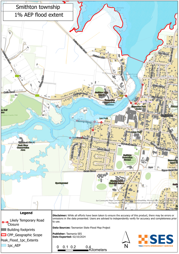
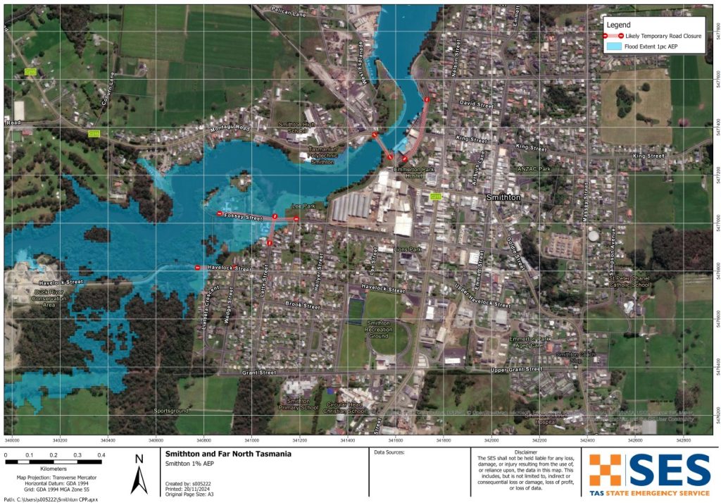
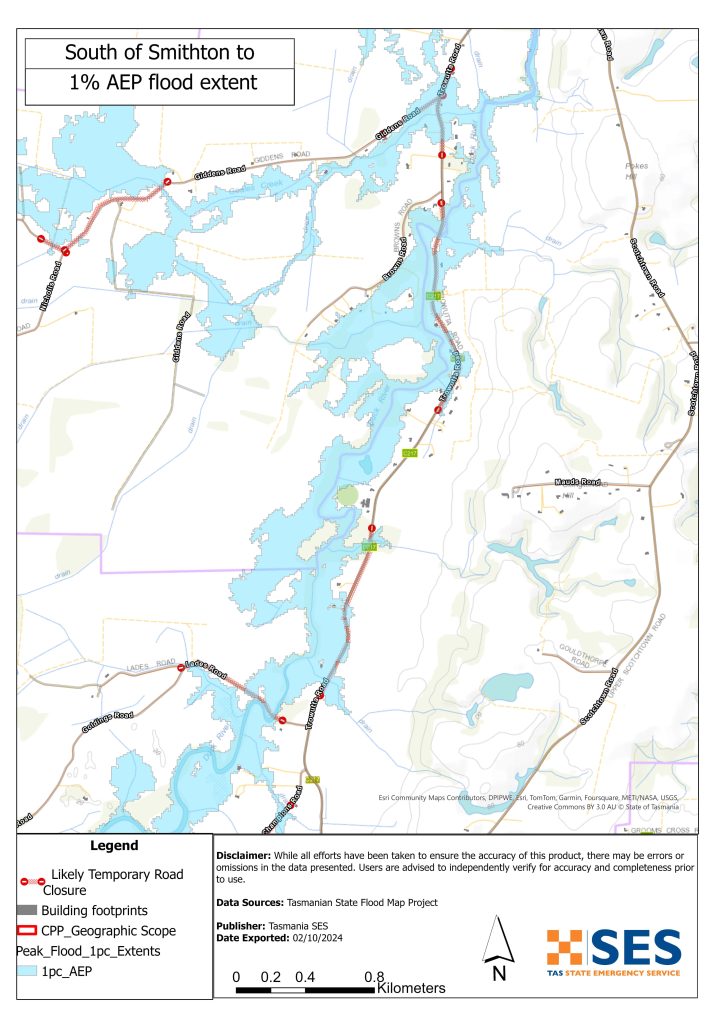
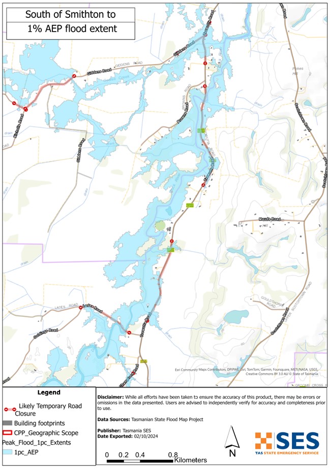
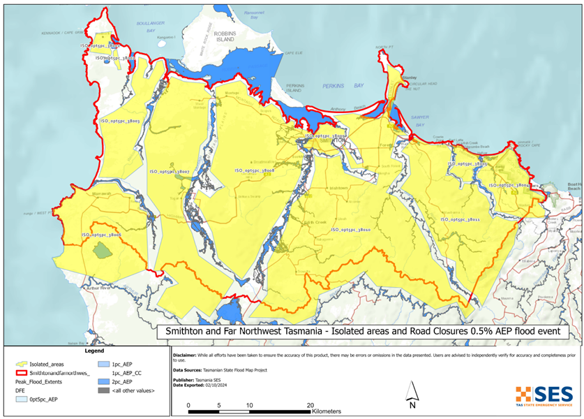
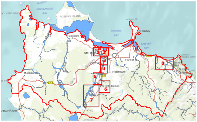
To see the maps in more detail, see the Tasmanian Strategic Flood Maps.
The far northwest of Tasmania has several rivers, including the
- Welcome
- Montagu
- Duck
- Black, and
- Detention Rivers.
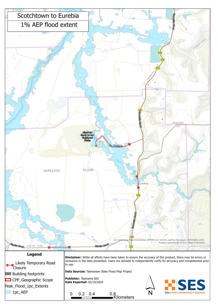
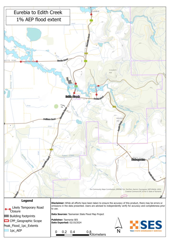
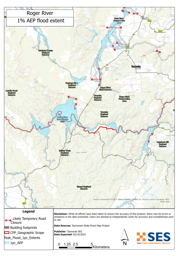
The Duck and Black Rivers, along with their smaller streams, can cause flooding in
- Smithton
- Scotchtown
- Edith Creek
- Roger River, and
- Forest.
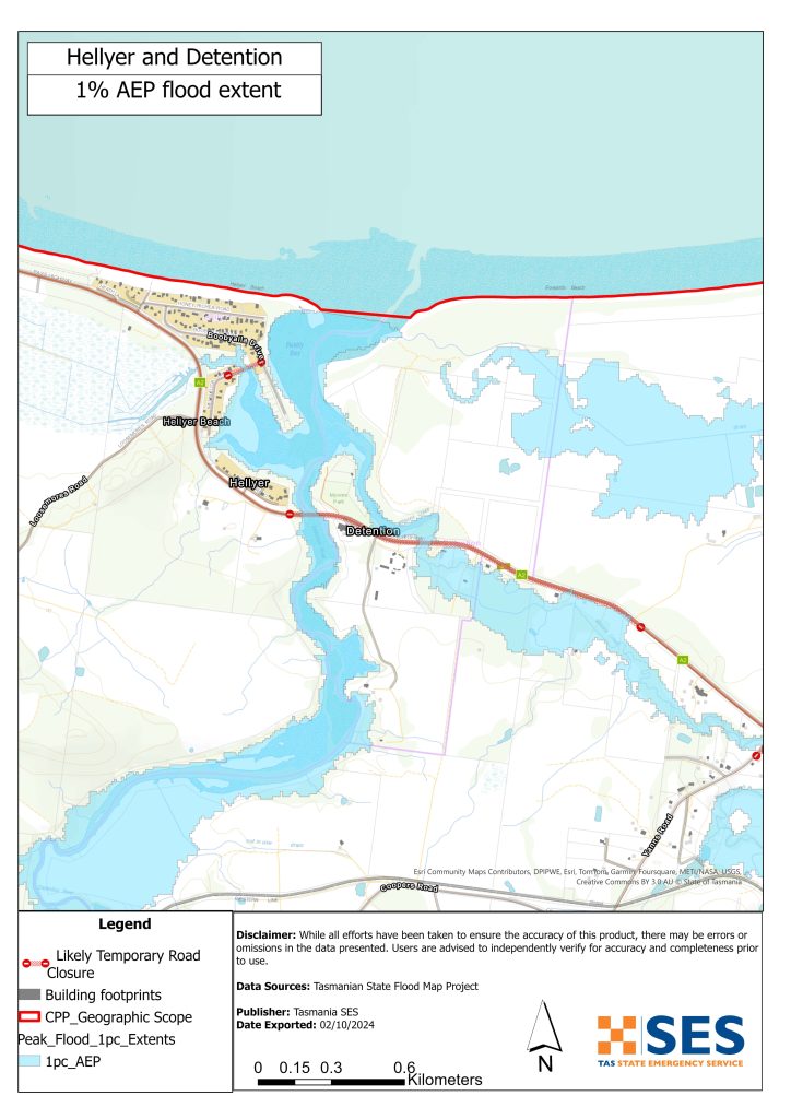
The Detention River can also cause flooding in
- Hellyer
- Rocky Cape, and
- Detention.
These maps show floods that have a 1% chance of happening in any year (Annual Exceedance probability (AEP).
Flood levels near the lower part of the of these rivers can change depending on when the flood peak and high tide happen.
In a moderate to major flood, roads in this region could be cut off for some time. If you need to leave your home, it’s important to go early, before floodwaters rise. Check warnings and advice at www.tasalert.com or listen to ABC local radio.
Floodwaters could leave your home isolated for several days. Even if your home doesn’t flood, you might not be able to get help if needed. Make sure you have enough food, water, and supplies for at least three days, and be ready for power and phone outages.
Are you at risk of flood?
Past recent flooding events across these catchments include:
- July 2000 – 3.45m at Duck River.
- October 2022 – At least six houses were close to inundation and many roads cut.
What should I do?
- Check the map to see whether your home or business could flood or be isolated.
- Check if you can safely get to your home, work, or school during a flood.
Prepare a Home Emergency Plan. See Get Ready for Emergencies – A guide for individuals and households to prepare for emergencies.
- If you are a primary producer, the SES Farm Flood Readiness Kit provides advice on preparing for a flood to help protect your animals and property. See www.ses.tas.gov.au/plan-prepare/flood-plan/ .
- If you will be isolated you may need to evacuate early.
- Assess your home or business and prepare it to minimise possible flood damage.
- If you are camping in a flood prone area, make sure you stay informed and move to higher ground early if a flood is likely.
No two floods are the same. Floods like the one shown in the map or worse will occur.
If you live in a low-lying area you may be at risk of flooding. Even if your home is safe, you may need to detour around flooded areas. Never drive through or enter flood waters.
Knowing what to do can save your life and help protect your property. Preparing a Home Emergency Plan is one of the best ways to prepare.
Include weather and rainfall triggers for action in your Home Emergency Plan.
Bureau of Meteorology (BoM) Forecasts, Warnings, and Observations
The Bureau of Meteorology (the Bureau) issues a Flood Watch when predicted weather might cause floods in one or two days. A Flood Watch may:
- be for a specific area such as Northwest Coast forecast district, or
- be generalised such as for northwest river systems
The Bureau of Meteorology (The Bureau) issues Severe Weather Warning for Heavy rain with the potential to cause flash flooding when forecast or observed weather may cause flash flooding. A Severe Weather Warning may:
- be for a specific area such as Smithton and surrounds; or
- a generalised areas such as northwest coast between Cape Grim and Table Cape and north of a line between Arthur River and Yolla.
The Bureau of Meteorology does not provide a specific flood warning for the Duck River.
Rainfall Monitoring and Observations
There is a BoM sub-daily rainfall gauge at Smithton Aerodrome, located on the northern edge of the Duck River catchment, and another at Luncheon Hill just beyond the southern edge of the catchment. Rainfall at Smithton Aerodrome and Luncheon Hill can be monitored on the Bureau website.
The N.W. Tasmania (West Takone) Radar is useful to be aware of where heavy rainfall is falling. Radar Rainfall estimates can fill in gaps in areas where there are no rainfall stations. Go to: http://www.bom.gov.au/products/IDR523.loop.shtml .
Understand the warnings and key information
Keep aware of what is happening around you. Check forecasts, observations and warnings regularly.
- TasALERT.com
- your local ABC radio station or
- the Bureau of Meteorology’s website.
 |
Advice (Yellow): an incident has started. There is no immediate danger. Stay up to date in case the situation changes. |
 |
Watch and Act (Orange): There is a heightened level of threat. Conditions are changing and you need to start taking action now to protect you and your family |
 |
Emergency Warning (Red): An Emergency Warning is the highest level of warning. You may be in danger and need to take action immediately. Any delay now puts your life at risk. |
 |
Community update (Blue): Specific information and updates for affected communities regarding a particular event or incident. |
 |
Incident (White): an incident is the initial occurrence of an event before it becomes an emergency warning. As soon as an incident is reported, TasALERT publishes basic information including the type and location of incident. |
For more information see www.ses.tas.gov.au/warnings/ .
Know your risk, get ready, reduce risk where you can, connect with others, stay alert and act safe.
Before a flood
1. Know your risk
Flooding often happens in Tasmania and can cause widespread and significant damage. In the past 200 years there have been 78 flood related deaths in Tasmania. This guide is to help you understand flood risk in your area.
2. Prepare your household
Have an emergency plan that covers storms and floods
Thinking about what you would do in a storm or flood means you are more prepared and everyone is safer. Have an emergency plan that everyone in your household understands. There are checklists to help you think through your plan – see Get Ready for Emergencies – A guide for individuals and households to prepare for emergencies.
Check your plan regularly and test it by everyone in the household thinking through a flooding scenario that may affect your household.
Prepare an Emergency Kit
Ready to Go
- Battery powered radio and torch, spare batteries
- Important information, such as your emergency plan
- A list of emergency numbers
- Food and water
- First aid kit
- Rubber or strong leather gloves
Pack when needed
- Warm clothes, sturdy shoes or boots
- Medicine, glasses or other essential items
- Mobile phone and phone charger
- Pet food and anything else they need
- Photos and special keepsakes
- Money
- Important documents, for example
- insurance papers
- passports and
- birth certificates
Regularly test batteries in radios and torches.
3. Reduce your risk from flooding where you can
- Think about storms, flooding and other hazards when buying, maintaining or developing property.
- Trim or remove trees and branches overhanging your home, business or near powerlines on your property.
- Keep your gutters and drains clear.
4. Connect with others
Know your neighbours and get involved in your community. A connected community is a safer and more resilient community in an emergency and can help everyone recover better afterwards. Check that family and neighbours are safe and aware of what’s happening.
During
5. Keep up to date
Keep aware of what is happening around you. Check forecasts, observations and warnings regularly.
- TasALERT
- your local ABC radio station or
- the Bureau of Meteorology’s website.
6. Act Safe
- Supervise children.
- Prepare for possible power, water or internet outages.
- Check your emergency kit is ready to go.
- Keep clear of flooded areas such as drains. NEVER walk, play, ride or drive in floodwater. You can’t always see what is under the water or how deep or fast-moving the water is. It is easy to be swept away and drown in as little as 20cm of fast-moving water. Flood water can be dangerous.
When your home may be flooded
- Put household items up high to minimise possible damage.
- Turn off the electricity and gas if it is safe to do so.
- A great way to stop sewerage flowing back into your home is to place sandbags inside plastic bags and use them to block toilets and cover drains and sinks.
- Leave while you can get out safely.
If you need to evacuate
- Follow the advice from SES / Tasmania Police.
- Take your emergency kit.
- Go to friends or family in a safer place or an evacuation centre.
- Let others know where you have gone.
Look after your animals
You are responsible for your animals in an emergency. If you have pets and other animals it will take you longer to evacuate in a flood or other emergency. Move livestock from flood prone areas well before flood waters may rise. For more information see
- RSPCA’s guidance on preparing for animals in an emergency
- Huon Valley Council’s advice on preparing an emergency pet plan
- the Primary producer farm flood readiness toolkit.
Avoid travelling during storms and after storms
- Do not go sightseeing. Sightseers delay emergency services and cause accidents.
- Watch out for hazards such as
- water over roads
- damaged powerlines
- landslides
- damaged roads
- falling trees or roofing iron.
- Never drive through flood waters. Most deaths and rescues in floods are from people driving through flood waters.
- Drive slowly and turn your headlights on roads not affected by flood waters.
After
- Keep listening for ABC Local Radio updates, road re-openings, community meetings, etc.
- If you left your home, do not return home until SES or Tasmania Police tell you it is safe to do so.
- Be aware of road hazards, such as mud or debris on the road, damaged roads/bridges and crews working on clean-up and repairs.
If your home has been damaged
- Stay at ground level while checking for damage. Be careful of fallen trees, broken glass, loose roofing or other hazards.
- Wear strong boots, gloves and protective clothes.
- Use a torch, never use matches or candles inside flood affected buildings.
- Boil all drinking water until you are told the tap water is safe again.
- Do not turn on electricity or gas until it is tested by a licensed electrician or gas fitter for safety.
- If your home is damaged and you need to stay somewhere else, take your emergency kit and pets with you
- Take photos of any damage if safe for you to do so and contact your insurance company.
- Supervise children.
- Check neighbours are okay.
For further information go to www.ses.tas.gov.au .
Staying informed and further information
Current warnings (TasAlerts) TasALERT.com
Bureau of Meteorology (BoM) bom.gov.au/tas/warnings
Emergency Broadcasters ABC 103.3 FM
TASSES Social Media facebook.com/sestasmania
Preparing for Flood Emergencies ses.tas.gov.au/flood-plan/
Circular Head Council www.circularhead.tas.gov.au | 6452 4800
Waratah-Wynyard Council warwyn.tas.gov.au | 6443 8333
National Relay Service (NRS) relayservice.gov.au
Disclaimer
The information in this guide is current at the date of publication. While every effort has been taken to ensure the validity and accuracy of the data presented, the State Emergency Service does not take responsibility for data error or omission. Please see the standard Tasmanian Government’s Copyright and Disclaimer Statement for more details https://www.tas.gov.au/codi .
The maps show potential flooding risks from consistent levels of rainfall across catchments, such as a 1% Annual Exceedance Probability (AEP). In flooding events, rainfall is likely to be more inconsistent across a catchment, so these flood maps should be considered indicative only. The mapped areas of flood risk show higher probability of inundation. Other areas have lower probability of flooding, but in severe and rare events (rarer than 1%AEP), other lower areas may be also at risk of inundation.