Flooding and coastal inundation information for communities and properties in Penguin, Sulphur Creek, Heybridge, Riana and surrounding areas
Version 1.0 January 2026
To see the maps in more detail, see the Tasmanian Strategic Flood Maps.
Know your flood risk and get ready
In a major flood, Penguin Creek may flood the town of Penguin. Other waterways in this area that could flood include
- Sulphur Creek, in the suburb of Sulphur Creek
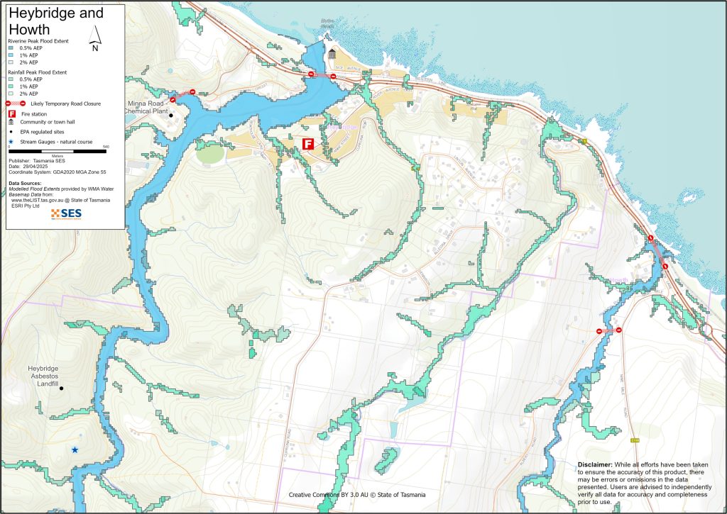
- Heybridge Rivulet, in Howth
- Blythe River, in Heybridge and Camena
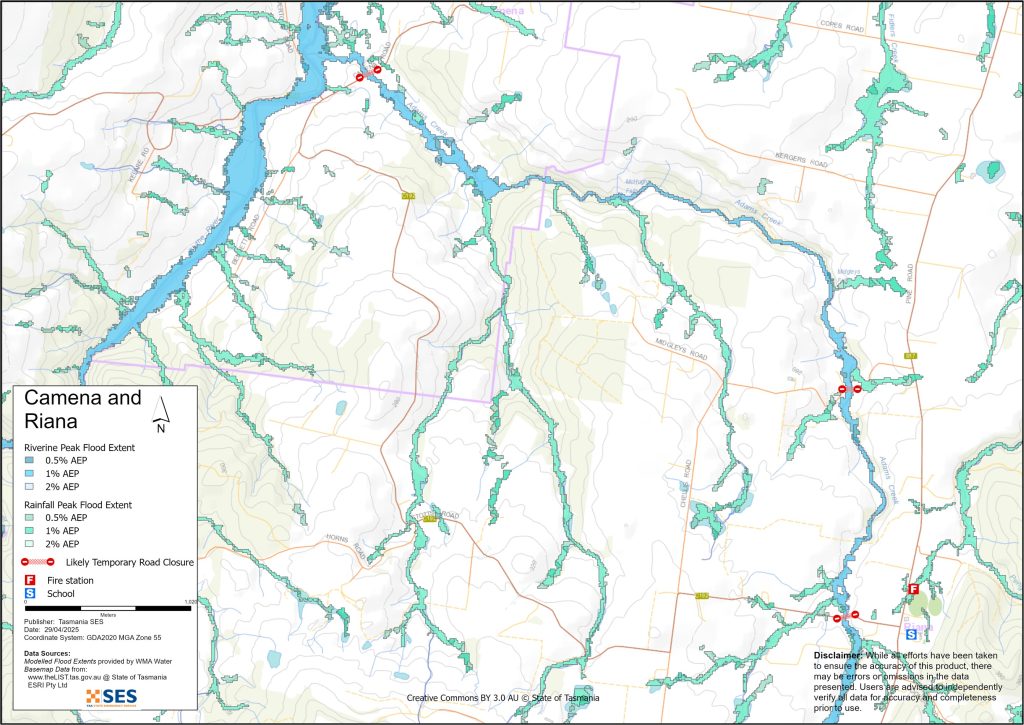
- Adams Creek, in Riana.
There could also be flooding caused by direct rainfall, or flash flooding, depending on where the rain falls and how heavy it is. If there is a storm during a high tide, or with big waves, there may also be coastal flooding in some parts.
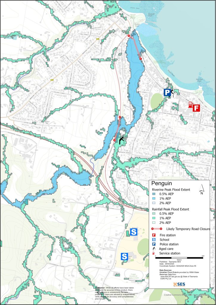
In the town of Penguin some streets around the creek may flood in moderate to major events. These include
- The bridge on Hayward Street over Penguin Creek may flood preventing access to
- Stubbs Court
- Howe Lane
- Killara Avenue
- Melli Court, and
- Carroo Court.
- In this part of Penguin, multiple houses may flood above floor height in a major event.
- Browns Lane may flood, cutting off several properties
- Deviation Creek may rise, causing local flooding on Deviation Street and Main Road
- Very heavy rain could overwhelm the stormwater system and flood low lying properties and parkland throughout the town.
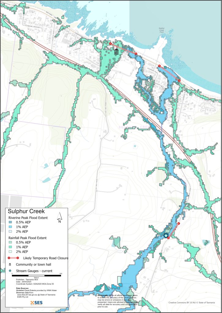
In Sulphur Creek a major flood could affect Preservation Drive, closing the road, and properties on
- Waterford Drive
- Bayvista Crescent, and
- Sandhaven Crescent.
In Preservation Bay there may be local flooding caused by heavy rain, mostly at the eastern end of the settlement. This will likely be for only a short time.
In Heybridge, Howth, Camena and Riana, flooding could close local roads, isolating some properties. The maps in this guide show the level of flooding that has a 1% chance of happening any year, known as the Annual Exceedance Probability (AEP). You are likely to experience flooding such as that shown in the maps in your lifetime. Tasmanians need to prepare for flood events that may not happen often as well as the minor flooding they may have experienced.
Even if your home does not flood, you should prepare for isolation plus potential power and telecommunications outages. For example
- Preservation Drive may flood in several places, mostly in Sulphur Creek
- The Hayward Street Bridge in Penguin could be under water
- The western end of Main Street in Penguin could be closed
- Camena Road, Stotts Road, Midgleys Road and other rural roads may be impassable.
Travel in the area is likely to be difficult or impossible until roads are clear. If you are safe at home or elsewhere, it is usually best you stay where you are until the flooding subsides, unless there is an emergency. If you need to evacuate, you should leave early, before flood waters rise.
Go to TasALERT.com or listen to ABC local radio 91.7 FM for warnings and advice.
Are you at risk of flood?
Penguin Creek has flooded on several occasions in recent history.
- Houses were flooded in 1977
- In January 2011 the area experienced extensive flooding with widespread damage and isolation.
- In October 2022 there was moderate flood damage along Penguin Creek and roads in the area, but not above the floor level of houses.
What should I do?
- Check the map to see whether your home or business could flood.
- Assess your home or business and prepare it to minimise possible flood damage.
- Check if you can safely get to your home, work, or school during a flood.
- Prepare your home or business to minimise possible flood damage. There is a guide to help you Get ready for emergencies – see ses.tas.gov.au.
- If you may be isolated. If you must have access to services, you may need to evacuate early.
Floods like the one shown in the maps, or worse, will occur again. No two floods are the same.
If you live in a low-lying area or near a watercourse, your house may flood. Even if your home is safe, you may need to detour around flooded areas or your road access may be cut. Never drive into or enter flood waters. Roads and bridges may be washed out or unsafe. Avoid travel during floods.
Knowing what to do can save your life and help protect your property. Having a Home Emergency Plan is one of the best ways to prepare. Decide on weather and rainfall triggers for when to act.
Bureau of Meteorology Forecasts, Warnings, and Observations
The Bureau issues a Flood Warning, Severe Weather Warning and/or Thunderstorm Warning for heavy rainfall that may lead to flash flooding whenever heavy rain is expected in an area. The time between the warning andheavy rain occurring can vary from an hour to 24 hours or more.
Whenever rain that may lead to flooding in this area is expected, the Bureau will issue:
- A Flood Watch – a “heads up” early advice of forecast weather that may lead to flooding
- A Flood Warning – giving a prediction of when flooding is likely to develop at gauge locations and possibly forecasting the likely peak river level. Warnings are updated regularly.
Rainfall Observations at Forthside, Burnie and Sprent can indicate possible flood risks. Given the very short warning times, it is best to act on the predictive BoM warnings rather than wait for any flood alerts during rainfall. There are no formal warning levels for waterways in this area.
The West Takone Radar is useful to be aware in real-time where heavy rainfall is falling. Radar Rainfall estimates can also fill in gaps in areas where there are no rainfall stations.
Understand the warnings and key information
Keep aware of what is happening around you. Check forecasts, observations and warnings regularly.
- TasALERT.com
- your local ABC radio station or
- the Bureau of Meteorology’s website.
 |
Advice (Yellow): an incident has started. There is no immediate danger. Stay up to date in case the situation changes. |
 |
Watch and Act (Orange): There is a heightened level of threat. Conditions are changing and you need to start taking action now to protect you and your family |
 |
Emergency Warning (Red): An Emergency Warning is the highest level of warning. You may be in danger and need to take action immediately. Any delay now puts your life at risk. |
 |
Community update (Blue): Specific information and updates for affected communities regarding a particular event or incident. |
 |
Incident (White): an incident is the initial occurrence of an event before it becomes an emergency warning. As soon as an incident is reported, TasALERT publishes basic information including the type and location of incident. |
For more information see www.ses.tas.gov.au/warnings/ .
Flood levels
While no two floods are the same, the following describes what you can expect at different flood levels around the area. Even if your property is not flooded, you need to think about access. Different levels of rainfall can cause flooding depending on its intensity, duration and how wet the ground is beforehand and where the rain falls.
Minor flooding
A minor flood can inundate parkland, drainage areas, low lying paddocks, orchards and other farmland as well as creekside areas in the town of Penguin. If stormwater systems are blocked, local areas of flooding may occur. In coastal areas, if heavy rain occurs during a high tide, this can be more common. Equipment and stock should be moved for their safety, and pets secured. There may also be some flooding across minor roads and low-lying streets.
Moderate flooding
There is more extensive flooding of parkland and agricultural land. Some buildings may flood to above floor height. Some properties may be isolated for a few hours as minor roads become flooded. The pedestrian and traffic bridges over Penguin Creek may begin to collect flood debris, increasing flooding risks.
Major flooding
During a major flood in this area, houses and streets near Penguin Creek will be at risk.
- Multiple properties in the area across the Hayward Street bridge will be flooded or isolated, and the bridge and surrounding streets closed.
- The creek will be hazardous, with debris gathering at pedestrian and traffic bridges and a very fast flow.
- Hiscutt Park will be covered in water and many adjoining backyards could flood.
Houses on the coast at Sulphur Creek are at risk of flooding, and Preservation Drive will be closed in several places. Multiple properties may be flooded and isolated.
The Blythe River and Heybridge Rivulet will rise, possibly flooding roads in Heybridge and Howth. And in rural inland areas, driveways and roads will be flooded and impassable and properties may be isolated for unpredictable lengths of time.
This level of flooding could be as a result of about 100mm of rain over 24 hours in South Riana, for example.
Know your risk, get ready, reduce risk where you can, connect with others, stay alert and act safe.
Before a flood
1. Know your risk
Flooding often happens in Tasmania and can cause widespread and significant damage. In the past 200 years there have been 78 flood related deaths in Tasmania. This guide is to help you understand flood risk in your area.
2. Prepare your household
Have an emergency plan that covers storms and floods
Thinking about what you would do in a storm or flood means you are more prepared and everyone is safer. Have an emergency plan that everyone in your household understands. There are checklists to help you think through your plan – see Get Ready for Emergencies – A guide for individuals and households to prepare for emergencies.
Check your plan regularly and test it by everyone in the household thinking through a flooding scenario that may affect your household.
Prepare an Emergency Kit
Ready to Go
- Battery powered radio and torch, spare batteries
- Important information, such as your emergency plan
- A list of emergency numbers
- Food and water
- First aid kit
- Rubber or strong leather gloves
Pack when needed
- Warm clothes, sturdy shoes or boots
- Medicine, glasses or other essential items
- Mobile phone and phone charger
- Pet food and anything else they need
- Photos and special keepsakes
- Money
- Important documents, for example
- insurance papers
- passports and
- birth certificates
Regularly test batteries in radios and torches.
3. Reduce your risk from flooding where you can
- Think about storms, flooding and other hazards when buying, maintaining or developing property.
- Trim or remove trees and branches overhanging your home, business or near powerlines on your property.
- Keep your gutters and drains clear.
4. Connect with others
Know your neighbours and get involved in your community. A connected community is a safer and more resilient community in an emergency and can help everyone recover better afterwards. Check that family and neighbours are safe and aware of what’s happening.
During
5. Keep up to date
Keep aware of what is happening around you. Check forecasts, observations and warnings regularly.
- TasALERT
- your local ABC radio station or
- the Bureau of Meteorology’s website.
6. Act Safe
- Supervise children.
- Prepare for possible power, water or internet outages.
- Check your emergency kit is ready to go.
- Keep clear of flooded areas such as drains. NEVER walk, play, ride or drive in floodwater. You can’t always see what is under the water or how deep or fast-moving the water is. It is easy to be swept away and drown in as little as 20cm of fast-moving water. Flood water can be dangerous.
When your home may be flooded
- Put household items up high to minimise possible damage.
- Turn off the electricity and gas if it is safe to do so.
- A great way to stop sewerage flowing back into your home is to place sandbags inside plastic bags and use them to block toilets and cover drains and sinks.
- Leave while you can get out safely.
If you need to evacuate
- Follow the advice from SES / Tasmania Police.
- Take your emergency kit.
- Go to friends or family in a safer place or an evacuation centre.
- Let others know where you have gone.
Look after your animals
You are responsible for your animals in an emergency. If you have pets and other animals it will take you longer to evacuate in a flood or other emergency. Move livestock from flood prone areas well before flood waters may rise. For more information see
- RSPCA’s guidance on preparing for animals in an emergency
- Huon Valley Council’s advice on preparing an emergency pet plan
- the Primary producer farm flood readiness toolkit.
Avoid travelling during storms and after storms
- Do not go sightseeing. Sightseers delay emergency services and cause accidents.
- Watch out for hazards such as
- water over roads
- damaged powerlines
- landslides
- damaged roads
- falling trees or roofing iron.
- Never drive through flood waters. Most deaths and rescues in floods are from people driving through flood waters.
- Drive slowly and turn your headlights on roads not affected by flood waters.
After
- Keep listening for ABC Local Radio updates, road re-openings, community meetings, etc.
- If you left your home, do not return home until SES or Tasmania Police tell you it is safe to do so.
- Be aware of road hazards, such as mud or debris on the road, damaged roads/bridges and crews working on clean-up and repairs.
If your home has been damaged
- Stay at ground level while checking for damage. Be careful of fallen trees, broken glass, loose roofing or other hazards.
- Wear strong boots, gloves and protective clothes.
- Use a torch, never use matches or candles inside flood affected buildings.
- Boil all drinking water until you are told the tap water is safe again.
- Do not turn on electricity or gas until it is tested by a licensed electrician or gas fitter for safety.
- If your home is damaged and you need to stay somewhere else, take your emergency kit and pets with you
- Take photos of any damage if safe for you to do so and contact your insurance company.
- Supervise children.
- Check neighbours are okay.
For further information go to www.ses.tas.gov.au .
Staying informed and further information
Current warnings (TasAlerts) TasALERT.com
Bureau of Meteorology (BoM) bom.gov.au/tas/warnings
Emergency Broadcasters ABC 103.3 FM
TASSES Social Media facebook.com/sestasmania
Preparing for Flood Emergencies ses.tas.gov.au/flood-plan/
Central Coast Council centralcoast.tas.gov.au 64274646
National Relay Service (NRS) relayservice.gov.au
Disclaimer
The maps show potential flooding risks from consistent levels of rainfall across catchments, such as a 1% Annual Exceedance Probability (AEP). In flooding events, rainfall is likely to be more inconsistent across a catchment, so these flood maps should be considered indicative only. The mapped areas of flood risk show higher probability of inundation. Other areas have lower probability of flooding, but in severe and rare events (rarer than 1% AEP), other lower areas may be also at risk of inundation.
The information in this guide is current at the date of publication. While every effort has been taken to ensure the validity and accuracy of the data presented, the State Emergency Service does not take responsibility for data error or omission. Please see the standard Tasmanian Government’s Copyright and Disclaimer Statement for more details.