Riverine flooding and flash flooding information for communities along the Pipers River and its tributaries
- Lilydale
- Underwood
- Karoola
- Lalla
- Turners Marsh
- Lower Turners Marsh
- Bangor
- North Lilydale
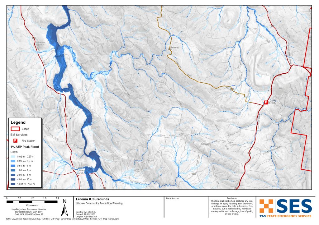
- Lebrina
- Retreat
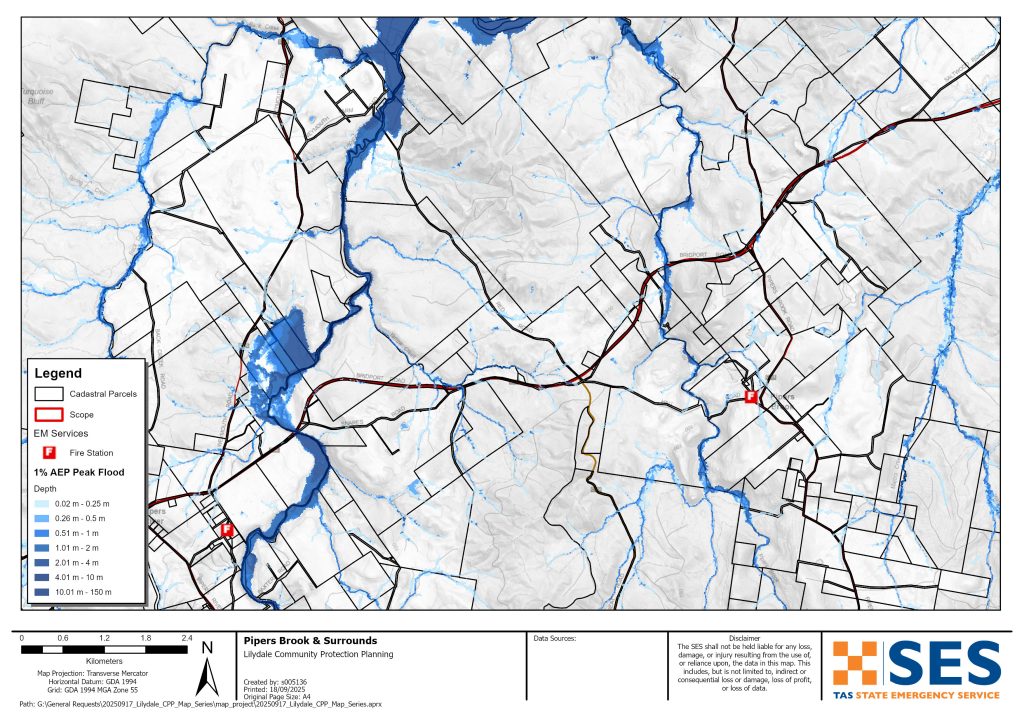
- Pipers Brook and
- Pipers River
- Bellingham
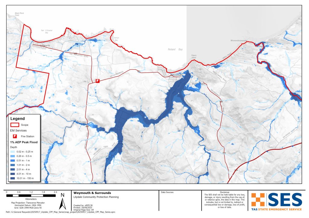
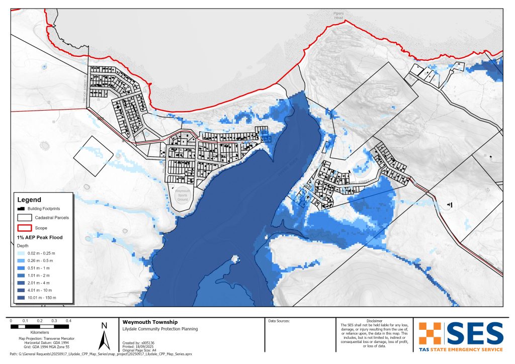
- Weymouth and
- Lulworth
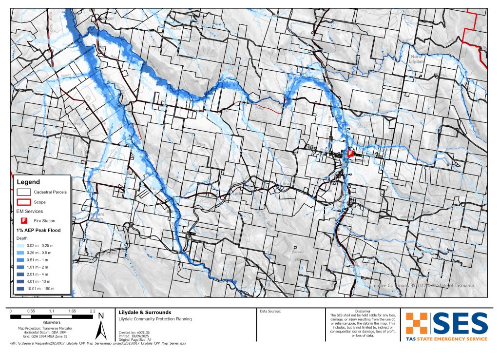
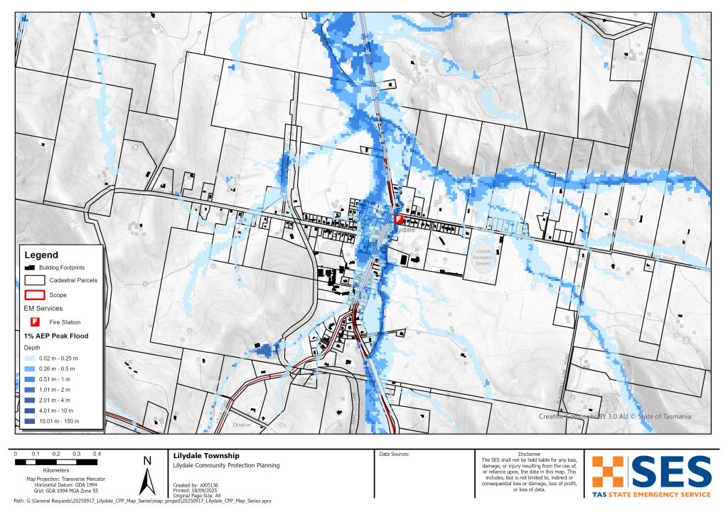
To see the maps in more detail, see the Tasmanian Strategic Flood Maps.
Parts of Lilydale township are prone to flash flooding from Rocky Creek after heavy rain, including Main Road. This flooding can be hard to predict. It can be difficult to give accurate and timely warnings.
Parts of communities near the mouth of the Pipers River can also flood, particularly at high tide. This includes parts of
- Bellingham
- Weymouth, and
- Lulworth.
Some properties around Karoola could also flood.
Flooding can cut many roads around the area for a short time after heavy rain. This can make driving dangerous. Areas around the Pipers River can become isolated for short periods as low-lying roads flood. Even if your home is not inundated, you should be prepared for
- major traffic routes to be cut plus
- potential power and telecommunications outages.
Are you at risk of flood?
- Areas around Lilydale and the Pipers River flooded in 1915, 1923, 1937, 1939, 2011, 2013, 2014 and 2016. Parts of Lilydale also flooded in October 2022.
What should I do?
- Check the map to see whether your home or business could flood. To see the maps in more detail, go to the Tasmanian Strategic Flood Maps online.
- Assess your home or business. Prepare it to minimise possible flood damage.
- Check if you can safely get to your home, work, or school during a flood.
- Prepare a Home Emergency Plan. See Get Ready for Emergencies – A guide for individuals and households to prepare for emergencies. If you run a business, check out the support by Business Tasmania to prepare for emergencies.
- If you may be isolated and you must have access to services, you may need to evacuate early, before floodwaters rise.
Floods like the one shown in the maps, or worse, will occur again. No two floods are the same.
If you live in a low-lying area or near a watercourse, your house may flood. Even if your home is safe, you may need to detour around flooded areas or your road access may be cut. Never drive into or enter flood waters. Roads and bridges may be washed out or unsafe. Avoid travel during floods.
Knowing what to do can save your life and help protect your property. Having a Home Emergency Plan is one of the best ways to prepare. Decide on weather and rainfall triggers for when to act.
The Bureau issues a Flood Watch when predicted weather might cause floods in the area. A Flood Watch for this area would be a generalised one for Central North river basins – a “heads up” early advice of forecast weather that may lead to flooding.
BoM does not issue formal flood level warnings for the Pipers River catchment. There are river level gauges on the Pipers River at
- Underwood, and
- Downstream of Yarrow Creek.
As the Pipers River is a short catchment, these gauges cannot give enough warning time.
It is best to act on BoM’s generalised flood watch warning, and observed rainfall, particularly at
- Mount Arthur Summit
- Pipers River Upstream of Yarrow Creek.
See www.bom.gov.au/tas/flood/northern.shtml
SES will issue TasALERT warnings if predicted or observed rainfall could cause flooding in the area. However, sometimes it is not possible to issue those warnings in a timely manner as the area is prone to localised flash flooding that can happen quickly.
Understand the warnings and key information
Keep aware of what is happening around you. Check forecasts, observations and warnings regularly.
- TasALERT.com
- your local ABC radio station or
- the Bureau of Meteorology’s website.
 |
Advice (Yellow): an incident has started. There is no immediate danger. Stay up to date in case the situation changes. |
 |
Watch and Act (Orange): There is a heightened level of threat. Conditions are changing and you need to start taking action now to protect you and your family |
 |
Emergency Warning (Red): An Emergency Warning is the highest level of warning. You may be in danger and need to take action immediately. Any delay now puts your life at risk. |
 |
Community update (Blue): Specific information and updates for affected communities regarding a particular event or incident. |
 |
Incident (White): an incident is the initial occurrence of an event before it becomes an emergency warning. As soon as an incident is reported, TasALERT publishes basic information including the type and location of incident. |
For more information see www.ses.tas.gov.au/warnings/ .
Flood levels
While no two floods are the same, the following describes what you can expect at different flood levels around the area. Even if your property is not flooded, you need to think about access. Different levels of rainfall can cause flooding depending on its intensity, duration and how wet the ground is beforehand and where the rain falls.
Do not drive through flooded roads – it is dangerous. It is best to avoid travel during heavy rain. Most flooding in the area will only last for a short period after rain stops. Flooding around Pipers River is generally only for a few hours or less.
Minor and moderate flooding
Low lying parts of some roads around the area can flood for short periods of time after heavy rain. Depending where rain falls, main roads that could be flooded for a short time in low lying parts include:
- Bridport Road near Pipers River crossing, near Ferny Hill Road and near #2431
- Lilydale Road south of Garcias Road
- Underwood Road near Jones Road
- Bangor Road east from Pipers River Rd turnoff and Second River Crossing
- Lalla Road Pipers River crossing east of Karoola Road
- Second River Rd east of Merthyr Park and near Second River crossing.
Local roads most at risk include:
- Glenford Farm Road, Underwood, multiple places
- Baxters Road Pipers River Crossing
- Security Road Pipers River crossing
- Lewis Road, Pipers River
- Colgraves Road, Pipers River
- Weymouth Farm Road Back Creek crossing.
Other roads that may flood for a short period include
- Gargias Road, Underwood
- Collins Road, Karoola
- Karoola Road, Pipers River crossing
- Dicksons Road, Karoola
- Back Creek Road, Back Creek crossing
- Weymouth Rod Back Creek crossing
- Lees Road, Bangor, Third River crossing.
If rain is very heavy, some low-lying properties around Lilydale, Bellingham and Weymouth may flood. Check the flood maps for details. The following roads may also flood.
- Venn Road, Pipers Brook Pipers Brook crossing
- Langs Road, Pipers Brook, Pipers Brook crossing
- Goullees Road, Underwood, Butchers Creek crossing
- Gollconda Road north of Lilydale, several places
- North Lilydale Road, North Lilydale, Second River crossing.
- Doaks Road, Lilydale township
- Parrys Road, Pipers River
- South Retreat Rd, Retreat Montgomery Creek crossing, also west of Geiss Road
- Lyndon Avenue, Bellingham
- Mahnkens Road, North Lilydale
Flooding may also cut main roads to the south, east and west of this area. Flooding could isolate many properties and communities for a short time.
Major floodingThis area has more than a 2% chance of major flooding any year (annual exceedance probability (AEP)). A 2% AEP level event may be as a result of, for example:
- At Mount Arthur, about 57mm rain in 2 hours, or 94mm in 6 hours
- At Lilydale about 32mm rain in 1 hour, or 47mm in 3 hours
- At Pipers River township, 33mm rain in 1 hour or 53 mm in 3 hours
With this level of rainfall, or less
- Flooding will likely cut most roads around the area for short periods. Delay travel, if possible, for your safety.
- In Lilydale up to 45 properties may flood, including along
- Main Road/ Lilydale Road/ Golconda Road,
- Station Road
- Charob Avenue.
While in many cases this flooding will be shallow and below floor height, in some places water could be dangerously deep as well as fast moving. If your property floods and you have to leave quickly, move overland uphill to a safer place.
This flooding is likely to be for a short time. Follow TasALERT for information on evacuation options.
A flood that has a 1% chance of happening any year is also likely to impact low lying homes and other buildings in the following areas.
- Karoola – 4 properties along Pipers River Road, Karoola Road and Lalla RoadBellingham – 10 properties mostly in Lyndon Street, but also Albert Street and Clifford StreetWeymouth – 5 properties in Major Street or along the Esplanade
- Lulworth – low level overland may impact 2 properties
- Stormwater run-off (direct rainfall impacts from very heavy rain) can also affect some other properties.
- Coastal inundation, coastal erosion, plus high tides can also affect Bellingham, Weymouth and Lulworth.
If there is particularly heavy rain, there is likely to be an extra 12 properties flooded around Lilydale, Karoola, Bellingham and Wymouth (0.5% AEP). Flooding on roads listed is likely to be deeper and more dangerous.
Know your risk, get ready, reduce risk where you can, connect with others, stay alert and act safe.
Before a flood
1. Know your risk
Flooding often happens in Tasmania and can cause widespread and significant damage. In the past 200 years there have been 78 flood related deaths in Tasmania. This guide is to help you understand flood risk in your area.
2. Prepare your household
Have an emergency plan that covers storms and floods
Thinking about what you would do in a storm or flood means you are more prepared and everyone is safer. Have an emergency plan that everyone in your household understands. There are checklists to help you think through your plan – see Get Ready for Emergencies – A guide for individuals and households to prepare for emergencies.
Check your plan regularly and test it by everyone in the household thinking through a flooding scenario that may affect your household.
Prepare an Emergency Kit
Ready to Go
- Battery powered radio and torch, spare batteries
- Important information, such as your emergency plan
- A list of emergency numbers
- Food and water
- First aid kit
- Rubber or strong leather gloves
Pack when needed
- Warm clothes, sturdy shoes or boots
- Medicine, glasses or other essential items
- Mobile phone and phone charger
- Pet food and anything else they need
- Photos and special keepsakes
- Money
- Important documents, for example
- insurance papers
- passports and
- birth certificates
Regularly test batteries in radios and torches.
3. Reduce your risk from flooding where you can
- Think about storms, flooding and other hazards when buying, maintaining or developing property.
- Trim or remove trees and branches overhanging your home, business or near powerlines on your property.
- Keep your gutters and drains clear.
4. Connect with others
Know your neighbours and get involved in your community. A connected community is a safer and more resilient community in an emergency and can help everyone recover better afterwards. Check that family and neighbours are safe and aware of what’s happening.
During
5. Keep up to date
Keep aware of what is happening around you. Check forecasts, observations and warnings regularly.
- TasALERT
- your local ABC radio station or
- the Bureau of Meteorology’s website.
6. Act Safe
- Supervise children.
- Prepare for possible power, water or internet outages.
- Check your emergency kit is ready to go.
- Keep clear of flooded areas such as drains. NEVER walk, play, ride or drive in floodwater. You can’t always see what is under the water or how deep or fast-moving the water is. It is easy to be swept away and drown in as little as 20cm of fast-moving water. Flood water can be dangerous.
When your home may be flooded
- Put household items up high to minimise possible damage.
- Turn off the electricity and gas if it is safe to do so.
- A great way to stop sewerage flowing back into your home is to place sandbags inside plastic bags and use them to block toilets and cover drains and sinks.
- Leave while you can get out safely.
If you need to evacuate
- Follow the advice from SES / Tasmania Police.
- Take your emergency kit.
- Go to friends or family in a safer place or an evacuation centre.
- Let others know where you have gone.
Look after your animals
You are responsible for your animals in an emergency. If you have pets and other animals it will take you longer to evacuate in a flood or other emergency. Move livestock from flood prone areas well before flood waters may rise. For more information see
- RSPCA’s guidance on preparing for animals in an emergency
- Huon Valley Council’s advice on preparing an emergency pet plan
- the Primary producer farm flood readiness toolkit.
Avoid travelling during storms and after storms
- Do not go sightseeing. Sightseers delay emergency services and cause accidents.
- Watch out for hazards such as
- water over roads
- damaged powerlines
- landslides
- damaged roads
- falling trees or roofing iron.
- Never drive through flood waters. Most deaths and rescues in floods are from people driving through flood waters.
- Drive slowly and turn your headlights on roads not affected by flood waters.
After
- Keep listening for ABC Local Radio updates, road re-openings, community meetings, etc.
- If you left your home, do not return home until SES or Tasmania Police tell you it is safe to do so.
- Be aware of road hazards, such as mud or debris on the road, damaged roads/bridges and crews working on clean-up and repairs.
If your home has been damaged
- Stay at ground level while checking for damage. Be careful of fallen trees, broken glass, loose roofing or other hazards.
- Wear strong boots, gloves and protective clothes.
- Use a torch, never use matches or candles inside flood affected buildings.
- Boil all drinking water until you are told the tap water is safe again.
- Do not turn on electricity or gas until it is tested by a licensed electrician or gas fitter for safety.
- If your home is damaged and you need to stay somewhere else, take your emergency kit and pets with you
- Take photos of any damage if safe for you to do so and contact your insurance company.
- Supervise children.
- Check neighbours are okay.
For further information go to www.ses.tas.gov.au .
Disclaimer
The maps show potential flooding risks from consistent levels of rainfall across catchments, such as a 1% Annual Exceedance Probability (AEP). In flooding events, rainfall is likely to be more inconsistent across a catchment, so these flood maps should be considered indicative only. The mapped areas of flood risk show higher probability of inundation. Other areas have lower probability of flooding, but in severe and rare events (rarer than 1% AEP), other lower areas may be also at risk of inundation.
The information in this guide is current at the date of publication. While every effort has been taken to ensure the validity and accuracy of the data presented, the State Emergency Service does not take responsibility for data error or omission. Please see the standard Tasmanian Government’s Copyright and Disclaimer Statement for more details.
Staying informed and further information
Current warnings (TasAlerts) TasALERT.com
Bureau of Meteorology (BoM) bom.gov.au/tas/warnings
Emergency Broadcasters ABC 91.7FM
TASSES Social Media facebook.com/sestasmania
Preparing for Flood Emergencies ses.tas.gov.au/ /flood-plan/
City of Launceston launceston.tas.gov.au 6323 3000
City of Launceston Emergency Management Hub
George Town Council georgetown.tas.gov.au
National Relay Service (NRS) relayservice.gov.au