Riverine flooding information for the lower Mersey River and Kings Creek
Version 1.0 January 2026
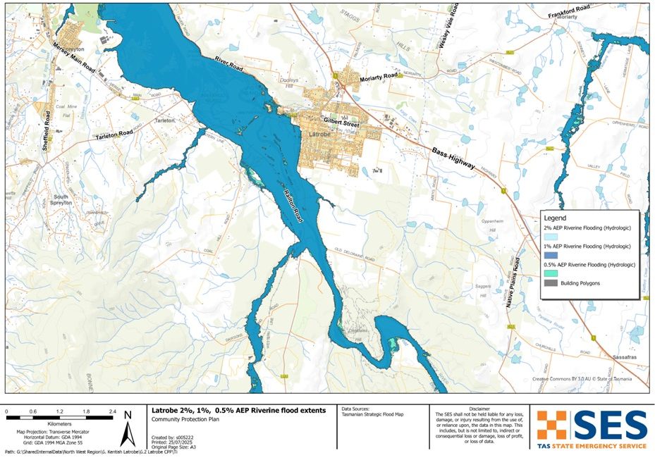
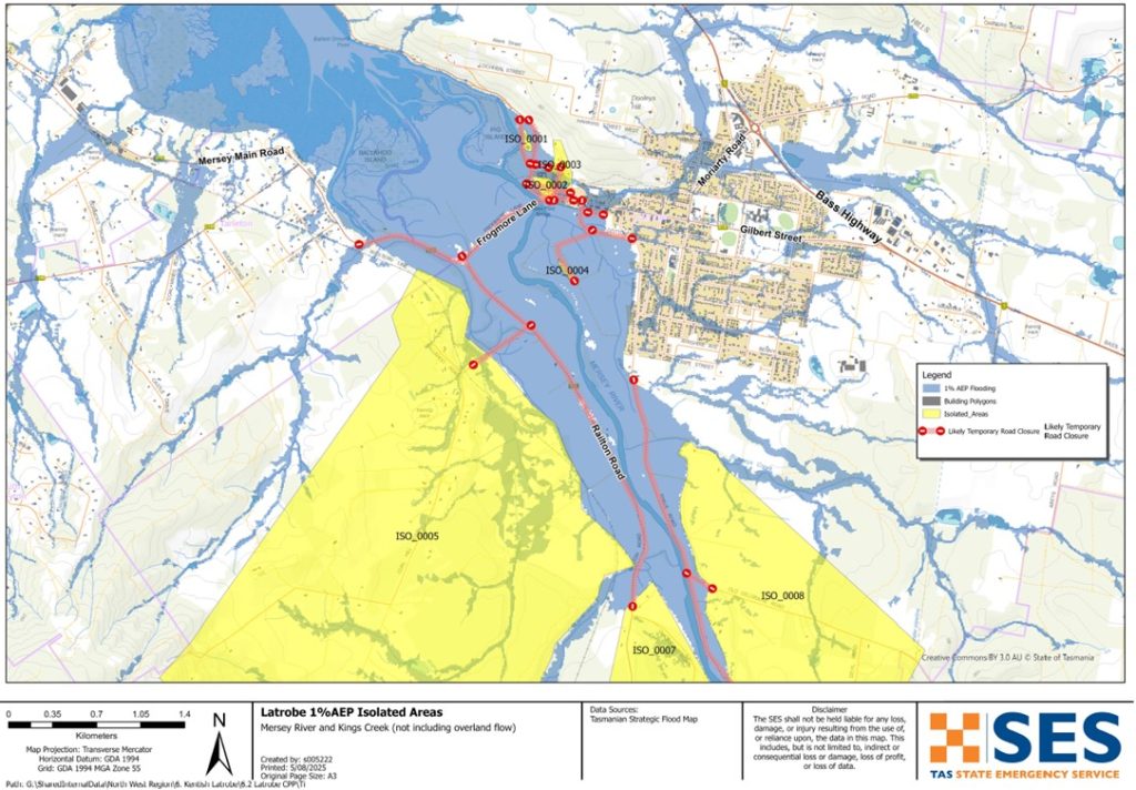
To see the maps in more detail, see the Tasmanian Strategic Flood Maps.
Latrobe and surrounds are likely to be impacted by flooding at the Mersey River and Kings Creek.
- If there is heavy rain upstream in the Mersey River, flood waters may reach and impact Latrobe.
- If there is heavy rain over Latrobe itself, Kings Creek and other stormwater can also cause local flash flooding.
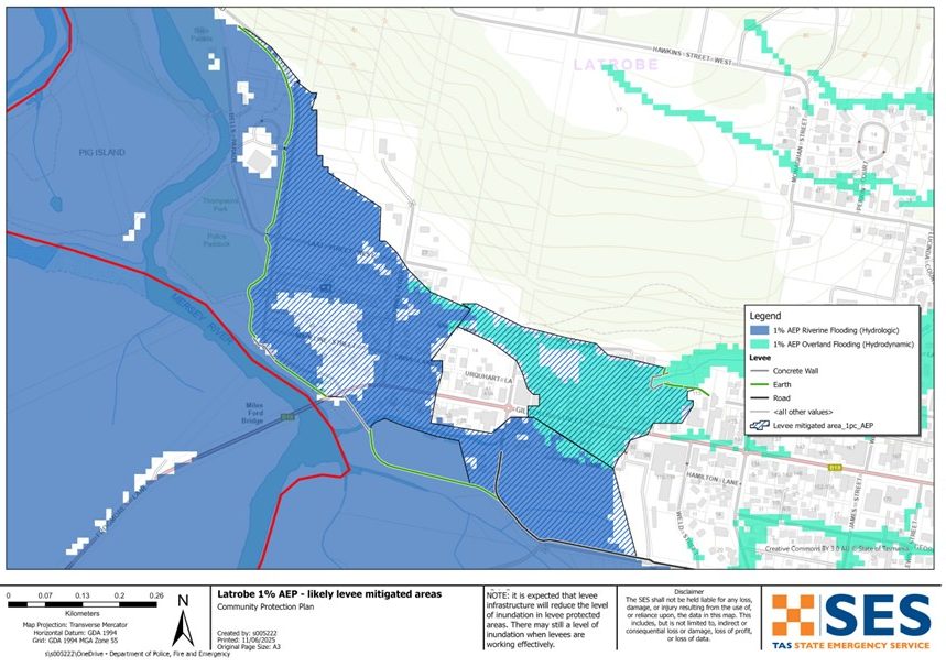
To help reduce flooding in the town, a flood levee and diversion system have recently been built. These are designed to lower the flood risk in parts of Latrobe. Areas inside the levee mitigated areas are expected to flood less often or not as deeply as before.
However, levees are not guaranteed to stop all flooding. SES recommends people evacuate levee protected areas in major flood events. Major flooding could see the levee overtop or fail. Major flooding has a 2% chance (2% Annual Exceedance Probability (AEP) of occurring in any year.
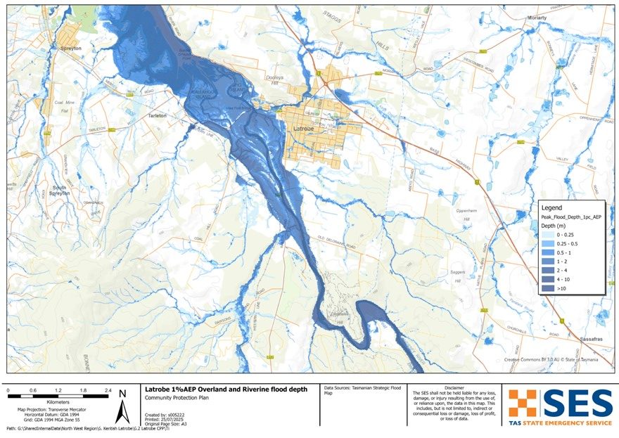
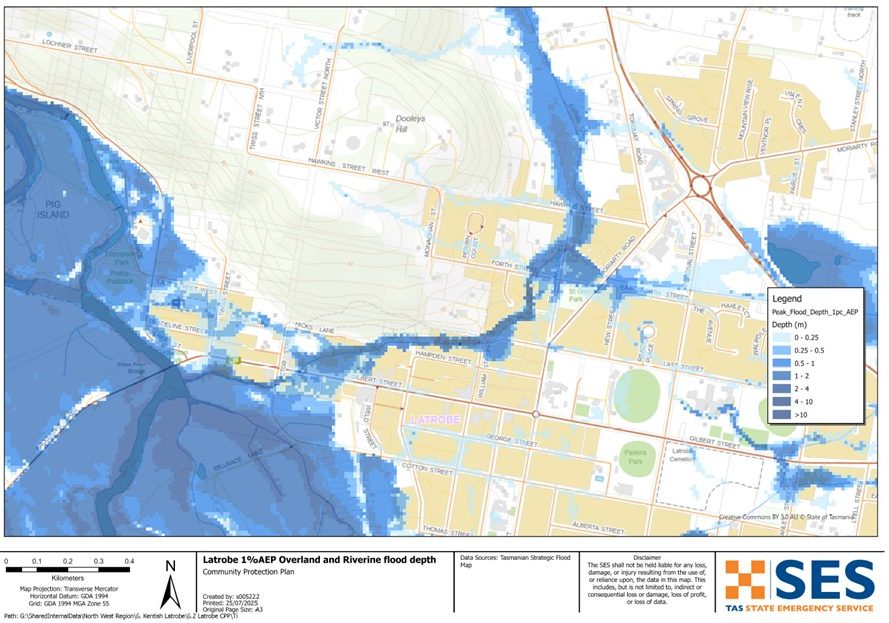
If your property is outside the levee mitigated area, your flood risk has not changed. There is also some uncertainty about how the new infrastructure might affect flooding in other areas nearby. The maps show areas that are likely to be inundated and isolated in a flood.
In a major flood, roads in and around Latrobe will be cut before some areas are flooded. If you need to evacuate, you should leave early, before flood waters rise.
Go to www.TasALERT.com or listen to ABC local radio for warnings and advice.
Flood waters may isolate your home for several days. Even if your home is not flooded, you may not be able to access help if needed. You should have supplies for at least three days and prepare for power and telecommunications outages.
Are you at risk of flood?
Past major flooding events around Latrobe since the construction of hydro-electric dams upstream include:
- August 1970 – This major flood was one of the largest recorded floods of the Mersey River and caused extensive inundation and damage to local businesses.
- March 1977 – This flood caused 14 homes to be inundated. Flooding was primarily due to flows in Kings Creek, not the Mersey River, so it occurred with much less warning than usual.
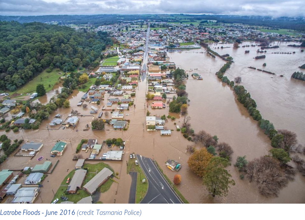
- June 2016 – Highest recorded flood at Latrobe. 121 properties were flooded, and there was significant damage to public infrastructure.
- October 2022 – This flood was similar in scale to the one in 1970, however people were better prepared. Despite widespread inundation, losses were minimised.
Before the dams, there were flooding events in 1884, 1893, 1894, 1923, 1929, 1944 and 1952.
Flood levels at Latrobe
While no two flood events are the same, the following table shows what you can expect for different flood levels around Latrobe. Even if your property is not flooded, you should think about access routes.
Minor flood
Rainfall likely to trigger this kind of flooding: 55-110mm/24hrs
River levels: 3.1m to 3.5m @ Mersey Rv at Latrobe Bridge river gauge
Likelihood off occurring in a year (AEP): 50% chance of occurring
Likely flood impacts: Flood water may cover low-lying areas. Farmland surrounding Latrobe is likely to be affected. Farm equipment and livestock in low-lying areas should be moved to higher ground. People living in very low-lying areas in and around Latrobe should be alert and stay informed in case conditions worsen.
Moderate flooding
Rainfall likely to trigger this kind of flooding: 85-150mm/24hrs
River levels: 3.6m to 3.9m @ Mersey Rv at Latrobe Bridge river gauge
Likelihood off occurring in a year (AEP): 10-20% chance of occurring
Flood impacts
Flood water will cover larger areas of land and enter some homes and other buildings.
Railton Road, Mersey Main Road, Coal Hill Road & Bells Parade may be flooded
In a high moderate flood water may enter houses & businesses in the low-lying areas of the town around:
- Mersey Main Road
- River Road/Twiss Street
- Shale Road
- Tarleton Road and
- Mersey Main Road
Major flooding
Rainfall likely to trigger this kind of flooding: 85-150mm/24hrs
River levels: 4.0m+ @ Mersey Rv at Latrobe Bridge river gauge
Likelihood off occurring in a year (AEP): 2% chance of occurring
Flood impacts
Widespread flooding may cause significant flooding of homes, businesses and other buildings.
The Mersey River may flood large parts of the town west of the supermarket/Kings Park will likely be inundated.
Flooding from Kings Creek, will likely affected houses in the surrounding area.
Many properties will flood including residences & businesses in::
- Gilbert Street
- Victor Street
- Urquhart Lane
- Twiss Lane
- Twiss Street
- Madeline Street
- Last Street West
- Railton Road
- Shale Road
- Mersey Main Road
- Kobie Lane
Properties in Coal Hill Road, Ballahoo Road, Old Deloraine Road and Devil Road may be isolated for days.
What should I do?
- Check the map to see whether your home or business is at risk of being flooded. If it is, you should have a plan for leaving during a flood event.
- Check if you can safely get to or from your home, work, or school during a flood. If you need to leave during a flood, make sure your route is safe or leave early before floodwaters rise. If you need to evacuate during a flood, make sure your route safe and think about:
- where you would go
- how you could get there
- what you need to take.
- Prepare your home or business to minimise possible flood damage.
- Prepare a Home Emergency Plan. See Get Ready for Emergencies – A guide for individuals and households to prepare for emergencies .
- If you have a business in the area, you should have a plan that covers flooding. Business Tasmania can help– see www.business.tas.gov.au/managing/risk_management .
- During a flood event, go to TasALERT.com or listen to ABC local radio to find out about evacuation centres or other places to shelter.
- TasALERT’s risk ready tool also lets you check your property’s exposure to a range of hazards.
Floods like the one shown in the map or worse will occur again. No two floods are the same.
If you live in a low-lying area, your house may flood. Even if your home is safe, you may need to detour around flooded areas or your road access may be cut. Never drive into or enter flood waters. Roads and bridges may be washed out or unsafe.
Knowing what to do can save your life and help protect your property. Having a Home Emergency Plan is one of the best ways to prepare. Decide on weather and rainfall triggers for when to act.
Bureau of Meteorology Forecasts, Warnings, and Observations
The Bureau of Meteorology (the Bureau) issues a Flood Watch when predicted weather might cause floods in one or two days. A Flood Watch may:
- be for a specific area such as Latrobe, or
- be generalised such as for north-west river basins
The Bureau issues Minor, Moderate and Major flood warnings specifically for the Mersey River, including predicted flood height. The time between the warning and flooding occurring can vary from a few hours to one or two days.
Rainfall Monitoring and Observations
River levels and rainfall in the Mersey River catchment (including the Fisher River and Arm River) can be monitored on the Bureau of Meteorology website. Go to www.bom.gov.au/tas/flood/northwestern.shtml
The N.W. Tasmania (West Takone) Radar is useful to be aware of where heavy rainfall is falling. Radar Rainfall estimates can fill in gaps in areas where there are no rainfall stations. Go to: www.bom.gov.au/products/IDR523.loop.shtml .
Understand the warnings and key information
Keep aware of what is happening around you. Check forecasts, observations and warnings regularly.
- TasALERT.com
- your local ABC radio station or
- the Bureau of Meteorology’s website.
 |
Advice (Yellow): an incident has started. There is no immediate danger. Stay up to date in case the situation changes. |
 |
Watch and Act (Orange): There is a heightened level of threat. Conditions are changing and you need to start taking action now to protect you and your family |
 |
Emergency Warning (Red): An Emergency Warning is the highest level of warning. You may be in danger and need to take action immediately. Any delay now puts your life at risk. |
 |
Community update (Blue): Specific information and updates for affected communities regarding a particular event or incident. |
 |
Incident (White): an incident is the initial occurrence of an event before it becomes an emergency warning. As soon as an incident is reported, TasALERT publishes basic information including the type and location of incident. |
For more information see www.ses.tas.gov.au/warnings/ .
Know your risk, get ready, reduce risk where you can, connect with others, stay alert and act safe.
Before a flood
1. Know your risk
Flooding often happens in Tasmania and can cause widespread and significant damage. In the past 200 years there have been 78 flood related deaths in Tasmania. This guide is to help you understand flood risk in your area.
2. Prepare your household
Have an emergency plan that covers storms and floods
Thinking about what you would do in a storm or flood means you are more prepared and everyone is safer. Have an emergency plan that everyone in your household understands. There are checklists to help you think through your plan – see Get Ready for Emergencies – A guide for individuals and households to prepare for emergencies.
Check your plan regularly and test it by everyone in the household thinking through a flooding scenario that may affect your household.
Prepare an Emergency Kit
Ready to Go
- Battery powered radio and torch, spare batteries
- Important information, such as your emergency plan
- A list of emergency numbers
- Food and water
- First aid kit
- Rubber or strong leather gloves
Pack when needed
- Warm clothes, sturdy shoes or boots
- Medicine, glasses or other essential items
- Mobile phone and phone charger
- Pet food and anything else they need
- Photos and special keepsakes
- Money
- Important documents, for example
- insurance papers
- passports and
- birth certificates
Regularly test batteries in radios and torches.
3. Reduce your risk from flooding where you can
- Think about storms, flooding and other hazards when buying, maintaining or developing property.
- Trim or remove trees and branches overhanging your home, business or near powerlines on your property.
- Keep your gutters and drains clear.
4. Connect with others
Know your neighbours and get involved in your community. A connected community is a safer and more resilient community in an emergency and can help everyone recover better afterwards. Check that family and neighbours are safe and aware of what’s happening.
During
5. Keep up to date
Keep aware of what is happening around you. Check forecasts, observations and warnings regularly.
- TasALERT
- your local ABC radio station or
- the Bureau of Meteorology’s website.
6. Act Safe
- Supervise children.
- Prepare for possible power, water or internet outages.
- Check your emergency kit is ready to go.
- Keep clear of flooded areas such as drains. NEVER walk, play, ride or drive in floodwater. You can’t always see what is under the water or how deep or fast-moving the water is. It is easy to be swept away and drown in as little as 20cm of fast-moving water. Flood water can be dangerous.
When your home may be flooded
- Put household items up high to minimise possible damage.
- Turn off the electricity and gas if it is safe to do so.
- A great way to stop sewerage flowing back into your home is to place sandbags inside plastic bags and use them to block toilets and cover drains and sinks.
- Leave while you can get out safely.
If you need to evacuate
- Follow the advice from SES / Tasmania Police.
- Take your emergency kit.
- Go to friends or family in a safer place or an evacuation centre.
- Let others know where you have gone.
Look after your animals
You are responsible for your animals in an emergency. If you have pets and other animals it will take you longer to evacuate in a flood or other emergency. Move livestock from flood prone areas well before flood waters may rise. For more information see
- RSPCA’s guidance on preparing for animals in an emergency
- Huon Valley Council’s advice on preparing an emergency pet plan
- the Primary producer farm flood readiness toolkit.
Avoid travelling during storms and after storms
- Do not go sightseeing. Sightseers delay emergency services and cause accidents.
- Watch out for hazards such as
- water over roads
- damaged powerlines
- landslides
- damaged roads
- falling trees or roofing iron.
- Never drive through flood waters. Most deaths and rescues in floods are from people driving through flood waters.
- Drive slowly and turn your headlights on roads not affected by flood waters.
After
- Keep listening for ABC Local Radio updates, road re-openings, community meetings, etc.
- If you left your home, do not return home until SES or Tasmania Police tell you it is safe to do so.
- Be aware of road hazards, such as mud or debris on the road, damaged roads/bridges and crews working on clean-up and repairs.
If your home has been damaged
- Stay at ground level while checking for damage. Be careful of fallen trees, broken glass, loose roofing or other hazards.
- Wear strong boots, gloves and protective clothes.
- Use a torch, never use matches or candles inside flood affected buildings.
- Boil all drinking water until you are told the tap water is safe again.
- Do not turn on electricity or gas until it is tested by a licensed electrician or gas fitter for safety.
- If your home is damaged and you need to stay somewhere else, take your emergency kit and pets with you
- Take photos of any damage if safe for you to do so and contact your insurance company.
- Supervise children.
- Check neighbours are okay.
For further information go to www.ses.tas.gov.au .
Staying informed and further information
Current warnings (TasAlerts) TasALERT.com
Bureau of Meteorology (BoM) bom.gov.au/tas/warnings
Emergency Broadcasters ABC 103.3 FM
TASSES Social Media facebook.com/sestasmania
Preparing for Flood Emergencies ses.tas.gov.au/flood-plan/
Latrobe Council latrobe.tas.gov.au 6426 4444
National Relay Service (NRS) relayservice.gov.au
Disclaimer
The maps show potential flooding risks from consistent levels of rainfall across catchments, such as a 1% Annual Exceedance Probability (AEP). In flooding events, rainfall is likely to be more inconsistent across a catchment, so these flood maps should be considered indicative only. The mapped areas of flood risk show higher probability of inundation. Other areas have lower probability of flooding, but in severe and rare events (rarer than 1% AEP), other lower areas may be also at risk of inundation.
The information in this guide is current at the date of publication. While every effort has been taken to ensure the validity and accuracy of the data presented, the State Emergency Service does not take responsibility for data error or omission. Please see the standard Tasmanian Government’s Copyright and Disclaimer Statement for more details.