Riverine flooding information for communities and properties on the lower Meander and South Esk Rivers
Version 1.0 January 2026
To see the maps in more detail, see the Tasmanian Strategic Flood Maps.
If the South Esk River or the Meander River have a major flood, people who live in
- Hadspen
- Blackstone Heights
- Travellers Rest, or
- surrounding areas
may experience flooded roads, driveways, parks and fields.
Livestock kept near the river may be at risk and farm infrastructure like pumps and tractors should be moved to safety. People who live on the river should relocate any equipment, boats or pontoons that can be moved.
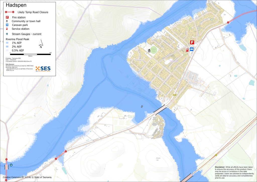
In Hadspen, there are some properties that could flood in the south of town, near where the Meander and the South Esk meet. The Lions Club Reserve will likely flood, along with the boat ramp and playground. Houses and roads near Beams Hollow may also flood. The stormwater systems in this part of Hadspen have been known to back up.
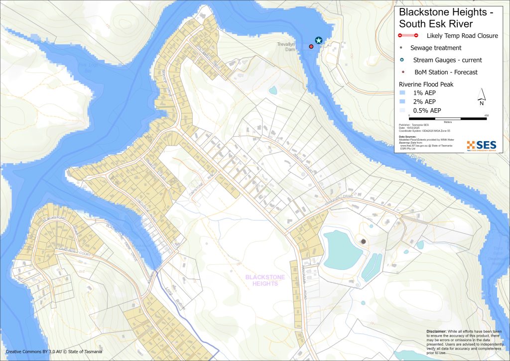
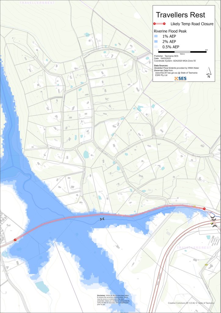
In Blackstone Heights, Blackstone Park will likely flood. Very heavy rain could cause landslips along the river, possibly affecting houses. There may also be flooding on the main access roads, Panorama Rd and Blackstone Rd, causing temporary isolation. It is possible that Meander Valley Rd could flood, isolating Travellers Rest.
Intense rainfall can cause flash flooding or overland flow. This kind of flooding is hard to predict and depends on where the rain falls.
The maps in this guide show the level of flooding that has a 1% chance of happening any year, known as the annual exceedance probability (AEP). You are likely to experience flooding such as that shown in the maps in your lifetime. Tasmanians need to prepare for flood events that may not happen often as well as the minor flooding they may have experienced.
Even if your home is not inundated, you should be prepared for isolation plus potential power and telecommunications outages.
Roads that could be flooded include:
- Meander Valley Rd
- Westwood Rd, at the bridge
- Blackstone Rd
- Panorama Rd
Depending on where the rain falls and how heavy it is, minor roads and driveways throughout this area may also be impassable. Travel in the area is likely to be difficult or impossible until roads are clear.
If you are safe at home or elsewhere, it is usually best you stay where you are until the flooding subsides, unless there is an emergency. If you need to evacuate, you should leave early, before flood waters rise.
Listen to ABC local radio 91.7FM for warnings and advice or check TasALERT.com.
To see the maps in detail, see the Tasmanian Strategic Flood Maps on the SES website.
Are you at risk of flood?
This area has seen large floods in recent years, including 2022 and 2016. Roads, bridges and houses flooded.
What should I do?
- Check the map to see whether your home or business could flood.
- Assess your home or business and prepare it to minimise possible flood damage.
- Check if you can safely get to your home, work, or school during a flood.
- Prepare a Home Emergency Plan. Consider if you need to evacuate before a flood. See Get Ready for Emergencies – A guide for individuals and households to prepare for emergencies.
- If you are a primary producer, the Farm Flood Readiness Kit provides advice on preparing for a flood to help protect your business and stock.
- If you may be isolated and you must have access to services, you may need to evacuate early.
- If you are camping in a flood prone area, make sure you stay informed and move to higher ground early if a flood is likely.
No two floods are the same. Floods like the one shown in the map or worse will occur again.
If you live in a low-lying area you may be at risk of flooding. Even if your home is safe, you may need to detour around flooded areas. Never drive through or enter flood waters.
Knowing what to do can save your life and help protect your property. Preparing a Home Emergency Plan is one of the best ways to prepare.
Include weather and rainfall triggers for action in your Home Emergency Plan.
Bureau of Meteorology Forecasts, Warnings, and Observations
The Bureau issues a Flood Warning, Severe Weather Warning and/or Thunderstorm Warning for heavy rainfall that may lead to flash flooding whenever heavy rain is expected in an area. The time between the warning andheavy rain occurring can vary from an hour to 24 hours or more.
Whenever rain that may lead to flooding along the Jordan River is expected, the Bureau will issue:
- A Flood Watch – a “heads up” early advice of forecast weather that may lead to flooding
- A Flood Warning – giving a prediction of when flooding is likely to develop at gauge locations and possibly forecasting the likely peak river level. Warnings are updated regularly.
SES and the Bureau will issue warnings when the Jordan River reaches the following levels.
Whenever rain that may lead to flooding along the Huon River is expected, the Bureau will issue warnings when the river reaches specific heights.
South Esk River
| River gauges | Alert | Minor | Moderate | Major |
| Fingal | 2.7m | 4.0m | 5.0m | 7.0m |
| Llewellyn | 2.7m | 4.0m | 5.0m | 8.5m |
| Perth | 4.3m | 7.2m | 8.9m | |
| Longford | 3.5m | 5.9m | 7.0m | |
| Trevallyn Pond Height AHD) | 128.2m | 129.9m | 130.9m | |
| Trevallyn Pond (Flow in Cumecs) | 420cu | 1400cu | 2250cu |
Meander River
Whenever rain that may lead to flooding along the Huon River is expected, the Bureau will issue warnings when the river reaches specific heights.
| River gauges | Alert | Minor | Moderate | Major |
| Meander | 1.8m | 2.0m | 3.0m | 3.5m |
| Deloraine Bridge | 2.0m | 2.5m | 3.0m | |
| Strathbridge | 5.0m | 6.5m | 7.0m | |
| Westwood Bridge | 4.0m | 6.0m | 7.0m |
Rainfall Observations at Meander, Deloraine, Launceston, Westwood Bridge and other rain gauges in the upper South Esk River can indicate possible flood risks to Hadspen and surrounds. Given the short warning times, it is best to act on the predictive BoM warnings rather than wait for any flood alerts during rainfall.
The NW Tasmania (West Takone) Radar is useful to be aware in real-time where heavy rainfall is falling. Radar Rainfall estimates can also fill in gaps in areas where there are no rainfall stations.
Understand the warnings and key information
Keep aware of what is happening around you. Check forecasts, observations and warnings regularly.
- TasALERT.com
- your local ABC radio station or
- the Bureau of Meteorology’s website.
 |
Advice (Yellow): an incident has started. There is no immediate danger. Stay up to date in case the situation changes. |
 |
Watch and Act (Orange): There is a heightened level of threat. Conditions are changing and you need to start taking action now to protect you and your family |
 |
Emergency Warning (Red): An Emergency Warning is the highest level of warning. You may be in danger and need to take action immediately. Any delay now puts your life at risk. |
 |
Community update (Blue): Specific information and updates for affected communities regarding a particular event or incident. |
 |
Incident (White): an incident is the initial occurrence of an event before it becomes an emergency warning. As soon as an incident is reported, TasALERT publishes basic information including the type and location of incident. |
For more information see www.ses.tas.gov.au/warnings/ .
Flood levels
While no two floods are the same, the following describes what you can expect at different flood levels around the area. Even if your property is not flooded, you need to think about access. Different levels of rainfall can cause flooding depending on its intensity, duration and how wet the ground is beforehand and where the rain falls.
Minor flooding
A minor flood can inundate parks, riverside areas, low lying paddocks and some yards. Stock should be moved for their safety. There may also be flooding across some minor roads.
Moderate flooding
There is more extensive flooding of agricultural land and some buildings may be impacted to above floor height. Bridges may become flooded and some properties may be isolated for a few hours as minor roads are closed. Properties and businesses in the south of Hadspen may be at risk.
Major flooding
If there is major flooding along the South Esk River there may be flooding in low-lying areas close to the river.
A major flood on the South Esk River means the river height is approaching 7m at Longford. If the major flood is occurring in the Meander, the river height will be 7m at Westwood Bridge.
Depending on where heavy rain falls there may also be flash flooding in the urban areas of Hadspen and Blackstone Heights. This kind of flooding is more difficult to predict and can depend on the stormwater system.
Major flooding could be caused by 30mm in one hour, or 100mm over 24 hours in Hadspen, for example.
Know your risk, get ready, reduce risk where you can, connect with others, stay alert and act safe.
Before a flood
1. Know your risk
Flooding often happens in Tasmania and can cause widespread and significant damage. In the past 200 years there have been 78 flood related deaths in Tasmania. This guide is to help you understand flood risk in your area.
2. Prepare your household
Have an emergency plan that covers storms and floods
Thinking about what you would do in a storm or flood means you are more prepared and everyone is safer. Have an emergency plan that everyone in your household understands. There are checklists to help you think through your plan – see Get Ready for Emergencies – A guide for individuals and households to prepare for emergencies.
Check your plan regularly and test it by everyone in the household thinking through a flooding scenario that may affect your household.
Prepare an Emergency Kit
Ready to Go
- Battery powered radio and torch, spare batteries
- Important information, such as your emergency plan
- A list of emergency numbers
- Food and water
- First aid kit
- Rubber or strong leather gloves
Pack when needed
- Warm clothes, sturdy shoes or boots
- Medicine, glasses or other essential items
- Mobile phone and phone charger
- Pet food and anything else they need
- Photos and special keepsakes
- Money
- Important documents, for example
- insurance papers
- passports and
- birth certificates
Regularly test batteries in radios and torches.
3. Reduce your risk from flooding where you can
- Think about storms, flooding and other hazards when buying, maintaining or developing property.
- Trim or remove trees and branches overhanging your home, business or near powerlines on your property.
- Keep your gutters and drains clear.
4. Connect with others
Know your neighbours and get involved in your community. A connected community is a safer and more resilient community in an emergency and can help everyone recover better afterwards. Check that family and neighbours are safe and aware of what’s happening.
During
5. Keep up to date
Keep aware of what is happening around you. Check forecasts, observations and warnings regularly.
- TasALERT.com
- your local ABC radio station or
- the Bureau of Meteorology’s website.
6. Act Safe
- Supervise children.
- Prepare for possible power, water or internet outages.
- Check your emergency kit is ready to go.
- Keep clear of flooded areas such as drains. NEVER walk, play, ride or drive in floodwater. You can’t always see what is under the water or how deep or fast-moving the water is. It is easy to be swept away and drown in as little as 20cm of fast-moving water. Flood water can be dangerous.
When your home may be flooded
- Put household items up high to minimise possible damage.
- Turn off the electricity and gas if it is safe to do so.
- A great way to stop sewerage flowing back into your home is to place sandbags inside plastic bags and use them to block toilets and cover drains and sinks.
- Leave while you can get out safely.
If you need to evacuate
- Follow the advice from SES / Tasmania Police.
- Take your emergency kit.
- Go to friends or family in a safer place or an evacuation centre.
- Let others know where you have gone.
Look after your animals
You are responsible for your animals in an emergency. If you have pets and other animals it will take you longer to evacuate in a flood or other emergency. Move livestock from flood prone areas well before flood waters may rise. For more information see
- RSPCA’s guidance on preparing for animals in an emergency
- the Primary producer farm flood readiness toolkit.
Avoid travelling during storms and after storms
- Do not go sightseeing. Sightseers delay emergency services and cause accidents.
- Watch out for hazards such as
- water over roads
- damaged powerlines
- landslides
- damaged roads
- falling trees or roofing iron.
- Never drive through flood waters. Most deaths and rescues in floods are from people driving through flood waters.
- Drive slowly and turn your headlights on roads not affected by flood waters.
After
- Keep listening for ABC Local Radio updates, road re-openings, community meetings, etc.
- If you left your home, do not return home until SES or Tasmania Police tell you it is safe to do so.
- Be aware of road hazards, such as mud or debris on the road, damaged roads/bridges and crews working on clean-up and repairs.
If your home has been damaged
- Stay at ground level while checking for damage. Be careful of fallen trees, broken glass, loose roofing or other hazards.
- Wear strong boots, gloves and protective clothes.
- Use a torch, never use matches or candles inside flood affected buildings.
- Boil all drinking water until you are told the tap water is safe again.
- Do not turn on electricity or gas until it is tested by a licensed electrician or gas fitter for safety.
- If your home is damaged and you need to stay somewhere else, take your emergency kit and pets with you
- Take photos of any damage if safe for you to do so and contact your insurance company.
- Supervise children.
- Check neighbours are okay.
For further information go to www.ses.tas.gov.au .
Staying informed and further information
Current warnings (TasALERT) TasALERT.com
Bureau of Meteorology (BoM) bom.gov.au/tas/warnings
Emergency Broadcasters ABC 91.7FM
TASSES Social Media facebook.com/sestasmania
Preparing for Flood Emergencies ses.tas.gov.au/ flood-plan/
Meander Valley Council meander.tas.gov.au 6393 5300
National Relay Service (NRS) relayservice.gov.au