Riverine and flash flooding information for communities between Montrose (Islet Rivulet) and Black Snake Rivulet (Granton), including Glenlusk, Rosetta, Chigwell, Berriedale and Austins Ferry
See also the nearby flood guide for Glenorchy city and suburb (south of Islet Rivulet)
Version 1.0 November 2025

To see map information in detail, go to www.gcc.tas.gov.au/residents/your-home/floods-and-stormwater/

Understand your flood risk and get ready
If there is a severe storm bringing heavy rainfall across the Wellington Range, several waterways from Rosetta to Granton could flood. Roads, schools, businesses and properties may flood and Brooker Highway could be cut in several places. This would mean that large parts of these suburbs may become isolated. Travel and business could be difficult or impossible for short periods.
As well as flooding from creeks and rivulets, heavy rain can directly cause flooding in this area. On the maps in this plan you can see flooding from both rivers and heavy rain.
During and following very heavy rain, there is a risk of landslides in steep areas that could damage roads and properties. Flooding and erosion from tides, storm and flood in the Derwent are also possible along the coastal areas in this plan.
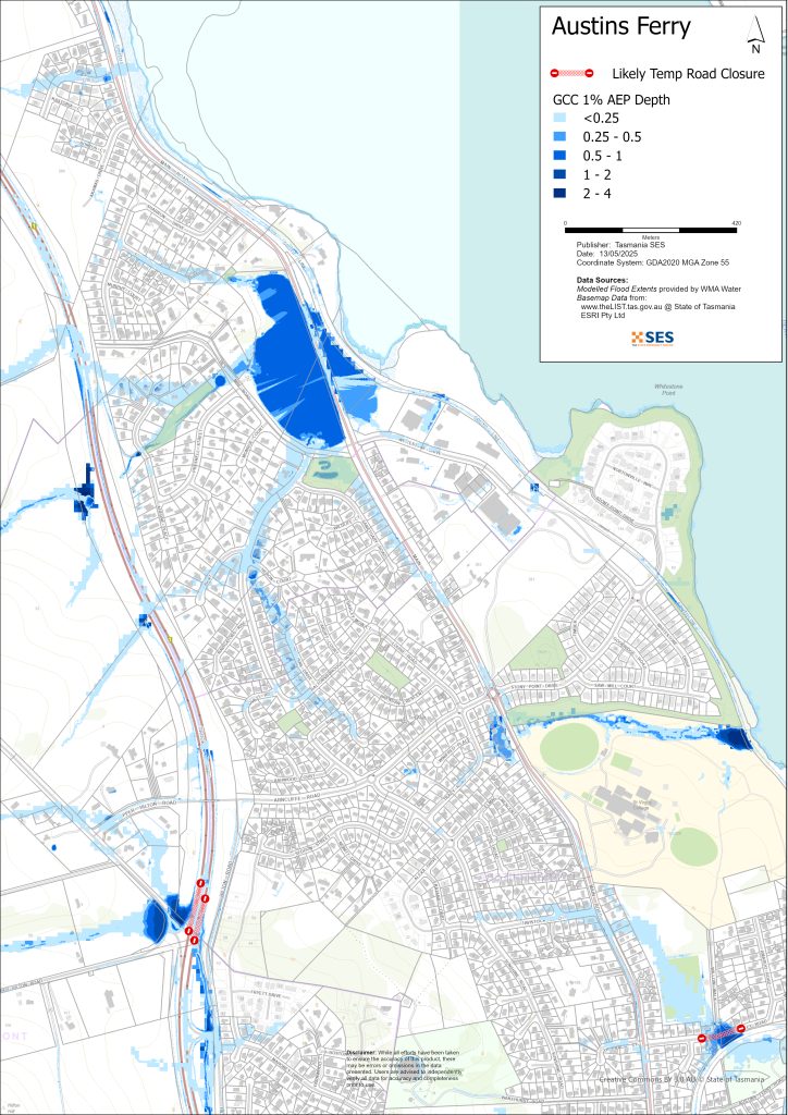
The maps in this guide show the level of flooding that has a 1% chance of happening any year (known as 1% Annual Exceedance Probability, or AEP). You are likely to experience flooding such as that shown in the maps in your lifetime. Tasmanians need to prepare for flood events that may not happen often, as well as the minor flooding they may have experienced.
Even if your home is not flooded, you should be prepared for isolation plus potential power and telecommunications outages. For example:
- The Brooker Highway may be cut at Granton, Austins Ferry, Claremont, Chigwell and at the edge of Montrose.
- Main Rd may be flooded in many places.
- Roads that cross the Brooker Hwy via underpass will likely flood.
Depending on where the rain falls and how heavy it is, many streets in this area may also be impassable. Travel in the area is likely to be difficult or impossible until roads are clear. If you are safe at home or somewhere else, it is usually best you stay where you are until the flooding subsides, unless there is an emergency. If you need to evacuate, you should leave early, before flood waters rise.
Go to TasALERT.com or listen to ABC local radio 936AM for warnings and advice.
Are you at risk of flood?
Heavy rain on kunanyi/ Mount Wellington can cause flash flooding in any of the surrounding waterways, often with little warning. Depending on how the rain falls, creeks, rivulets and stormwater runoff can cause flash flooding that is difficult to predict.
The flooding history of this area is not well recorded.
What should I do?
- Check the maps to see whether your home or business could flood.
- Check your home or business and prepare it, to minimise possible flood damage.
- Check if you can safely get to your home, work, or school during a flood.
- Prepare a Home Emergency Plan. See Get Ready for Emergencies – A guide for individuals and households to prepare for emergencies.
- If you may be isolated and you must have access to services, you may need to evacuate early.
If you live in a low-lying area or near a watercourse, your house may flood. Even if your home is safe, you may need to detour around flooded areas or your road access may be cut. Never drive into or enter flood waters. Roads and bridges may be washed out or unsafe. Avoid travel during floods.
Knowing what to do can save your life and help protect your property. Having a Home Emergency Plan is one of the best ways to prepare. Decide on weather and rainfall triggers for when to act.
Bureau of Meteorology Forecasts, Warnings, and Observations
The Bureau issues a Flood Warning, Severe Weather Warning and/or Thunderstorm Warning for heavy rainfall that may lead to flash flooding whenever heavy rain is expected in an area. The time between the warning andheavy rain occurring can vary from an hour to 24 hours or more.
Glenorchy, Hobart and Kingborough Councils share a flood warning system as areas around kunanyi/ Mount Wellington have similar flash-flooding risks and timeframes. This system allows your local council and SES to judge and monitor the flood risk, and release warnings as needed. There are no formal warning levels for the waterways in this area as the river systems are too short.
Rainfall Observations at Claremont, Bridgewater, Mount Dromedary, Collinsvale and other nearby rain gauges can indicate possible flood risks. Given the very short warning times, it is best to act on the predictive BoM warnings rather than wait for any flood alerts during rainfall.
The Mt Koonya Radar is useful to be aware in real-time where heavy rainfall is falling. Radar Rainfall estimates can also fill in gaps in areas where there are no rainfall stations.
Understand the warnings and key information
Keep aware of what is happening. Check forecasts, observations and warnings regularly.
- TasALERT.com
- your local ABC radio station or
- the Bureau of Meteorology’s website.
 | Advice (Yellow): an incident has started. There is no immediate danger. Stay up to date in case the situation changes. |
 | Watch and Act (Orange): There is a heightened level of threat. Conditions are changing and you need to start taking action now to protect you and your family |
 | Emergency Warning (Red): An Emergency Warning is the highest level of warning. You may be in danger and need to take action immediately. Any delay now puts your life at risk. |
 | Community update (Blue): Specific information and updates for affected communities regarding a particular event or incident. |
 | Incident (White): an incident is the initial occurrence of an event before it becomes an emergency warning. As soon as an incident is reported, TasALERT publishes basic information. |
For more information see www.ses.tas.gov.au/warnings/ .
Flood levels
While no two floods are the same, the following describes what you can expect at different flood levels around the area. Even if your property is not flooded, you need to think about access. Different levels of rainfall can cause flooding depending on its intensity, duration and how wet the ground is beforehand and where the rain falls.
Minor Flooding
Minor flooding can affect low lying areas, parkland, orchards and areas near the creeks and rivulets. Vehicles and livestock should be moved for their safety. Some minor roads may be flooded.
Moderate Flooding
In a moderate flood, more extensive flooding occurs and more land, roads and some buildings may be flooded.
Abbotsfield Rivulet, Hilton Creek, Faulkners Rivulet and Islet Rivulet may flood some properties during a moderate flood. It is unlikely that the flooding will be above the floor height of houses.
Major Flooding
In a major flood, flooding will be widespread across this area but mostly shallow. The most hazardous flooding will likely be on:
- Brooker Highway near Berriedale Road
- Brooker Highway north of Box Hill Road, near Upper Hilton Rd
- Main Road near Goulds Lagoon
- Claremont Link Road near the Claremont College Campus,
- Abbotsfield Road, Strathaven Drive and Marys Hope Road
- Roseneath Rivulet
Properties near the rivulets and creeks in this area may be flooded above floor height during a major flood. Many roads, including major transit routes, will be flooded and impassable.
Glenlusk may be cut off from the coast for a time.


Know your risk, get ready, reduce risk where you can, connect with others, stay alert and act safe.
Before a flood
1. Know your risk
Flooding often happens in Tasmania and can cause widespread and significant damage. In the past 200 years there have been 78 flood related deaths in Tasmania. This guide is to help you understand flood risk in your area.
2. Prepare your household
Have an emergency plan that covers storms and floods
Thinking about what you would do in a storm or flood means you are more prepared and everyone is safer. Have an emergency plan that everyone in your household understands. There are checklists to help you think through your plan – see Get Ready for Emergencies – A guide for individuals and households to prepare for emergencies.
Check your plan regularly and test that everyone in the household understands what would need to happen in a flood.
Prepare an Emergency Kit
Ready to Go
Battery powered radio and torch, spare batteries
Important information, such as your emergency plan
A list of emergency numbers
Food and water
First aid kit
Rubber or strong leather gloves
Pack when needed
Warm clothes, sturdy shoes or boots
Medicine, glasses or other essential items
Mobile phone and phone charger
Pet food and anything else they need
Photos and special keepsakes
Important documents, for example
– insurance papers
– passports and
– birth certificates
Regularly test batteries in radios and torches.
3. Reduce your risk from flooding where you can
- Think about storms, flooding and other hazards when buying, maintaining or developing property.
- Trim or remove trees and branches overhanging your home, business or near powerlines on your property.
- Keep your gutters and drains clear.
4. Connect with others
Know your neighbours and get involved in your community. A connected community is a safer and more resilient community in an emergency and can help everyone recover better afterwards. Check that family and neighbours are safe and aware of what’s happening.
During
5. Keep up to date
Keep aware of what is happening around you. Check forecasts, observations and warnings regularly.
- www.TasALERT.gov.au
- your local ABC radio station or
- the Bureau of Meteorology’s website.
6. Act Safe
- Supervise children.
- Prepare for possible power, water or internet outages.
- Check your emergency kit is ready to go.
- Keep clear of flooded areas such as drains. NEVER walk, play, ride or drive in floodwater. You can’t always see what is under the water or how deep or fast-moving the water is. It is easy to be swept away and drown in as little as 20cm of fast-moving water. Flood water can be dangerous.
When your home may be flooded
- Put household items up high to minimise possible damage.
- Turn off the electricity and gas if it is safe to do so.
- A great way to stop sewerage flowing back into your home is to place sandbags inside plastic bags and use them to block toilets and cover drains and sinks.
- Leave while you can get out safely.
If you need to evacuate
- Follow the advice from SES / Tasmania Police.
- Take your emergency kit.
- Go to friends or family in a safer place or an evacuation centre.
- Let others know where you have gone.
Look after your animals
You are responsible for your animals in an emergency. If you have pets and other animals it will take you longer to evacuate in a flood or other emergency. Move livestock from flood prone areas well before flood waters may rise. For more information see
- RSPCA’s guidance on preparing for animals in an emergency
- Huon Valley Council’s advice on preparing an emergency pet plan
- City of Hobart’s advice on Pet Management and Emergencies
Avoid travelling during and after storms
- Do not go sightseeing. Sightseers delay emergency services and cause accidents.
- Watch out for hazards such as
- water over roads
- damaged powerlines
- landslides
- damaged roads
- falling trees or roofing iron.
- Never drive through flood waters. Most deaths and rescues in floods are from people driving through flood waters.
- Drive slowly and turn your headlights on roads not affected by flood waters.

After
- Keep listening for ABC Local Radio updates, road re-openings, community meetings, etc.
- If you left your home, do not return home until SES or Tasmania Police tell you it is safe to do so.
- Be aware of road hazards, such as mud or debris on the road, damaged roads/bridges and crews working on clean-up and repairs.
If your home has been damaged
- Stay at ground level while checking for damage. Be careful of fallen trees, broken glass, loose roofing or other hazards.
- Wear strong boots, gloves and protective clothes.
- Use a torch, never use matches or candles inside flood affected buildings.
- Boil all drinking water until you are told the tap water is safe again.
- Do not turn on electricity or gas until it is tested by a licensed electrician or gas fitter for safety.
- If your home is damaged and you need to stay somewhere else, take your emergency kit and pets with you.
- Take photos of any damage if safe for you to do so and contact your insurance company.
- Supervise children.
- Check neighbours are okay.
For further information go to www.ses.tas.gov.au
Staying informed and further information
Current warnings (TasAlerts) TasALERT.com
Bureau of Meteorology bom.gov.au/tas/warnings
Emergency Broadcasters ABC 936AM
TAS SES Social Media facebook.com/sestasmania
SES – Preparing for Flood Emergencies
Glenorchy City Council 6216 6800
Disclaimer
The maps show potential flooding risks from consistent levels of rainfall across catchments, such as a 1% Annual Exceedance Probability (AEP). In flooding events, rainfall is likely to be more inconsistent across a catchment, so these flood maps should be considered indicative only. The mapped areas of flood risk show higher probability of inundation. Other areas have lower probability of flooding, but in severe and rare events (rarer than 1%AEP), other lower areas may be also at risk of inundation.
The information in this guide is current at the date of publication. While every effort has been taken to ensure the validity and accuracy of the data presented, the State Emergency Service does not take responsibility for data error or omission. Please see the standard Tasmanian Government’s Copyright and Disclaimer Statement for more details.